

The Golden Cathedral in Neon Canyon
In a previous post, I talked about the Golden Cathedral in Neon Canyon in Grand Staircase-Escalante National Monument. This canyon and the Cathedral are awe-inspiring examples of the beauty of the monument, with pretty desert varnish staining the walls of the “neon” orange/red/yellow-ish canyon, and the golden splendor of the Cathedral with its two unique potholes leading to the upper part of the canyon. My one complaint with the trail to the canyon is that it is quite long (about 12 miles RT), and you have to cross the Escalante River several times before you can even get to the mouth of Neon Canyon. So, I was very excited when I read about a much more direct trail to the canyon, which (I would guess) brings the distance down to around 8 miles RT. Finally, a shorter trail to the Golden Cathedral and Neon Canyon! Actually, there is no real trail, but with a compass and a good sense of direction it would be difficult to get lost. On maps, this way of getting to the canyon is called “The Beeline Route”, although I think we might have followed the edge of Fence Canyon a bit more than if we had really taken the straight Beeline Route.

Desert flowers we found on our way across Egypt
To get to Neon Canyon, you will need to park in the Egypt parking area, located 37°35’36” N 111°13’05” W miles down the Hole in the Rock Road. From the town of Escalante drive 5.0 miles east toHole-in-the-Rock Road. Drive 16.3 miles to the road toEgypt. This road branches off to the left and does have a signpost (road No. 240). Travel 10 miles east down this road to end. There are some other roads that branch off, just follow the signposts toEgyptor, if there are no signpost, follow the more traveled road. (I think that if you stay right you’ll get there, but I’m not sure on this.) Just before the parking area there is a fork in the road. Take the right fork; again there is a signpost to show the way. The parking area is a fairly large sandy area with the trailhead starting at the left-hand side and immediately descending into the canyon. There is a trail register where you can get permits to camp overnight in the Egypt area. The condition of the road to Egypt will depend on a lot of things, including how recently it has rained. The first time we visited, the road was very rough, and 4×4 would have been helpful. The second time, it wasn’t quite as rough (although it was still quite a bit worse than the Hole in the Rock Road). Both times, you couldn’t have made it without high clearance, although 4×4 would have been optional (we made it in a 2-wheel-drive van both times). A few places are slightly sandy, and the road would be impassible when wet.

Looking out towards Neon Canyon from the first slickrock “cliff”. Notice the domed monolith in the very middle of the picture.
The trail begins on the side of the cliff next to the parking area. Just follow the cliff until you see a way to climb down and start descending the slickrock. There are some cairns, but in general you just want to get down to the bottom of the slickrock to the wash below. Here there is a sign that says something about “You are now entering Glen Canyon National Recreation Area” (although I think Neon is in the national monument). While you are still on the slickrock, look out across the view, and note the huge, dome-like monolith sticking up almost directly across the desert from you. You will be heading towards this dome, so if you have a compass, take a reading now. Once you get down to the bottom of the slickrock, you will not be able to see the dome anymore.

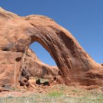
Looking at the entrance to Neon Canyon from the top of the second slickrock “cliff”
Near the sign about Glen Canyon, some footprints lead off into the desert, out of the wash to your right/straight. Follow these footprints. You can follow footprints basically all the way to the mouth of Neon Canyon. You can also use a compass or a GPS to get you to the right place. There is no trail, so you will just have to head in the right direction, and correct your mistake once you can see the dome again. After you have walked 2 or 3 miles from the bottom of the slickrock, you will come to another slickrock “cliff”. From here, you should be able to see the dome again; scramble down the slickrock, and head towards the dome.

Walking up Neon Canyon
After another mile or so, you will come to the edge of the canyon with the Escalante River flowing along the bottom of it. You probably will not be able to see the river, but you will be able to see the trees along the bottom of the canyon. There is a trail down at GPS coordinate 37°36’19” N 111°10’30” W. If you don’t have a GPS, the trail is located across the canyon from the mouth of Neon Canyon, across from the dome you’ve been walking towards. The trail down is very sandy (some people call it a sand dune), but eventually it will drop you at the bottom of the canyon. Walk across the canyon towards the mouth of Neon Canyon. You will need to cross the Escalante River before you can get into Neon. When we crossed it in mid-May, the water was only knee-deep, but the water level will vary depending on how much rain the monument has had recently. After you have cross the Escalante River, head up into Neon Canyon. The entrance to Neon Canyon is at GPS coordinate 37°36’40” N 111°10’03” W.

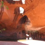
Potholes in the Golden Cathedral in Neon Canyon
The canyon itself is beautiful, with desert varnish striping the walls, and green vegetation setting it all off. Depending on how much water is in the canyon, you may have to do some scrambling to get to the Golden Cathedral, 1 mile up Neon Canyon. However, I did not find it too difficult a walk. You will know you are in the Golden Cathedral when the canyon seems to come to an end at a wall with a large puddle at the bottom of it. Above the puddle are two holes (pot holes) in the wall/roof of the canyon. These lead to the upper part of Neon Canyon. Many people start in Upper Neon, and then repel down through the potholes and land in the puddle. Several did this while we were enjoying the Cathedral.
Return by the way you came. The trail back up out of the Escalante River Valley can be found at GPS coordinate 37°36’21” N 111°10’08” W. I found the hike much more enjoyable with the shorter hike, and the less times crossing the river. It was a bit of an adventure trying to go overland by just following footprints, but it was worth it, and I’m ready to try it again sometime!

Climbers repelling through the potholes
Round Trip Trail Length: About 8 miles. Distance will vary.
Facilities: Trail register at parking area for trailhead.
Fees: None
Trail 
![]()
![]()
![]()
![]()
Road ![]()
![]()
![]()
Signs ![]()
![]()
![]()
Scenery
Would I go 100 miles out of my way for this? ![]()
Overall Rating: ![]()
![]()
This Week’s Featured Product!
With nearly 60 hikes in Grand Staircase-Escalante National Monument, this is a great guide for exploring the region.


Pingback: Anne's Travels » Amazing Golden Cathedral in a Neon Canyon
Great! thanks for the share!
Excellent blog post. Will pay a visit to Anne's Travels » Neon Canyon: The Beeline Route for more information.
Thanks Ann. These are the best directions I’ve found for my trip out there this fall.
Hi Chuck,
Glad it’s helpful! It was so much better than the Fence Canyon route I’d taken before that I wanted to make it easy for anyone who’s up to trying the trek.
Have fun–it’s beautiful!
Anne
Love your site and learned a lot about this Neon Canyon. I will try to go there as soon as I feel there would be no rain or bad weather.
What is the best time to visit it?
Thanks a lot.
William,
I’ve always visited Neon Canyon in the Spring (April & cooler spells in May). It’s been warm, but not so hot as to drive us to higher elevations. October would be another nice time to hike, although September may be cool enough for hiking. Check the weather before you travel; you don’t want to be in Neon or near the Escalante River if there is rain in the area.
Hope that helps.
Anne
Anne,
Thanks for your valuable advice. I will call before visiting the Neon Canyon. Thanks a lot. Best Regards,
Pingback: Anne's Travels » 10 Reasons I Choose Dayhiking over Backpacking
Pingback: 10 Best (and worst) Day Hikes in Grand Staircase-Escalante
Pingback: 12 Trails that Require Hands & Knees, River Crossings, and Other Adventures
Pingback: 15 of the Best Day Hikes in Southern Utah - Anne's Travels
Pingback: Hole in the Rock: Scramble to Lake Powell! - Anne's Travels
Pingback: Top 10 Pages on Anne’s Travels in 2014 - Anne's Travels
Pingback: Day-hiking Coyote Gulch: Waterfalls, Arches, and Desert Solitude