Getting to the most rewarding views can be hard. In fact, it can be very difficult. Sometimes we just have to leave the comforts of a defined trail behind to cross the waist-deep rivers, scramble up scree and talus on our hands and knees, or brave the snowfields to get to the best of what the wilderness has to offer. Of course, the good thing about these deterrents is that they keep most of the crowds at bay. And the feeling of accomplishment when we “make it” is ten times greater than if we’d just ambled down a trail to the viewpoint. At any rate, for those of us with an adventurous spirit, these 10 trails that require hands & knees, river crossings, and other adventures will be fun…if a bit daunting at times!
(Affiliate links are present on this page.)
So, without further ado, here they are, in no particular order!
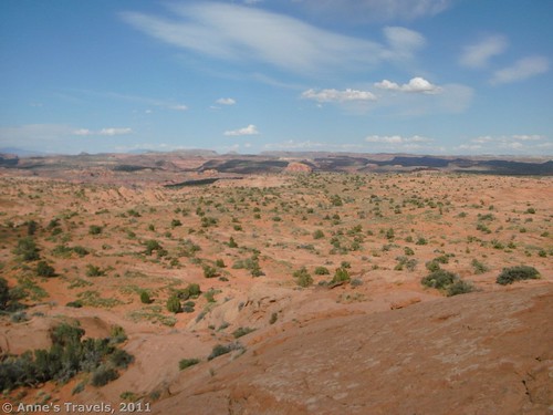
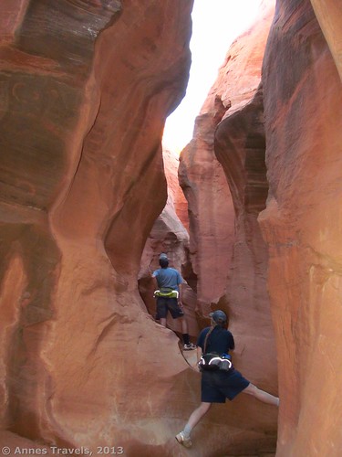
- Neon Canyon – the Beeline Route to Neon Canyon in Grand Staircase-Escalante National Monument, Utah, is a double adventure. First, there is only the vaguest of trails leading across the rolling Utah desert (think: yucca and sage brush in the rolling sandhills). Second, to enter the canyon, you have to cross the Escalante River, which at the very best I’ve seen it, is over my knees. There was no particular danger of being swept away, but it’s still a scary thing to be moving through opaque rushing water of that depth. Your reward? The incredible Golden Cathedral!
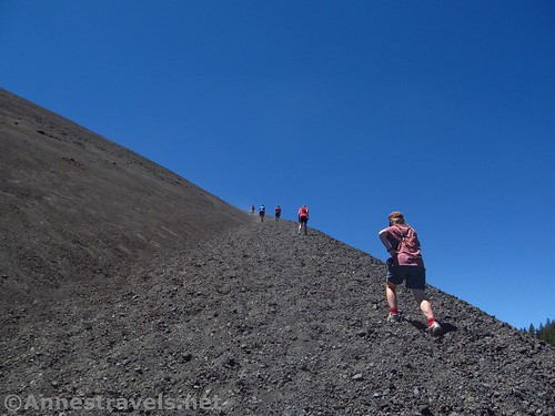
The trail up the Lassen Cinder Cone 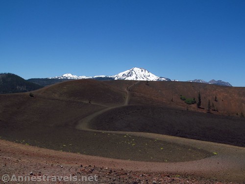
The view across the top of the cinder cone - Lassen Cinder Cone. Ok, so you’d rather have a trail? The cinder cone in Lassen Volcanic National Park in northern California has a trail the entire way up the cone and down into the crater, but just because there is a trail doesn’t mean it’s easy. For every step up the cinder cone, you have the joy of sliding back at least half a step, getting your shoes full of cinders, and risking toppling onto your knees due to the unsteady footing. Fun? Oh, yes!
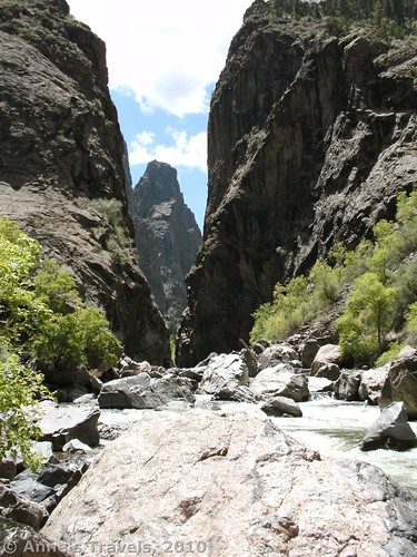
At the bottom of Long Draw 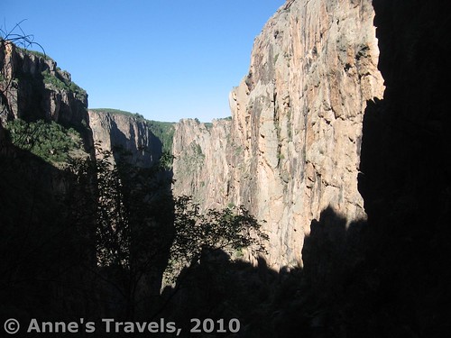
Scrambling down Long Draw - Long Draw. If you think sliding on cinders is fun, you should really try out the Long Draw Route to the bottom of Black Canyon of the Gunnison in Colorado. The route (it can’t be considered a trail) makes its way through brush and over rock slides toward the Gunnison River (which thankfully you won’t have to cross), with a wide strip of Poison Ivy to traverse before reaching your final destination. Utilizing your hands is more than optional here!
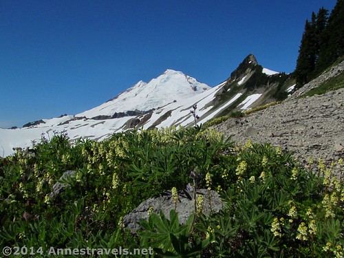
Mt. Baker from the Ptarmigan Ridge Trail 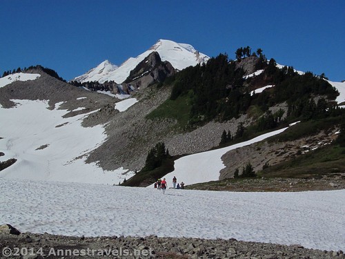
Crossing snowfields on the Ptarmigan Ridge Trail - Ptarmigan Ridge. Meanwhile, in the remote northwestern part of Washington State, one of the premier hikes (in terms of views) is snowed in 100% of the year. Ok, in August and September you generally don’t need crampons or ice axes, and the trail will be well-enough packed across the snow that you can’t get too terribly lost if you know where you’re going. But be ready for the snow, because it’s always there, and you can’t get to the best of the views without walking across it!
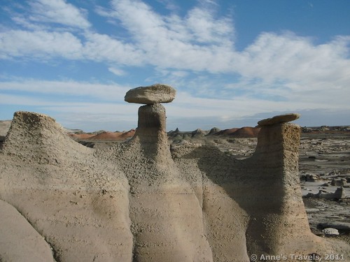
Hoodoos in Bisti 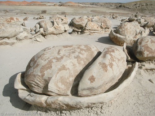
Cracked Eggs formations - Bisti. Now, if you would rather have no trail to snowy or difficult trails, check out the Bisti Wilderness Area of New Mexico. There are literally no trails here – save for the occasional cow trail – but the fantastic rock formations, badlands, and hoodoos are a photographer’s dream and an adventurer’s paradise. When can I go back?
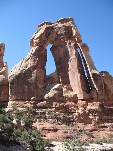
Druid Arch 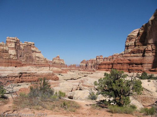
Looking back down the canyon, away from Druid Arch - Druid Arch. Some national parks have trails, and others have “trails”. The one to Druid Arch in the Needles District of Canyonlands National Park, Utah, is one of those “trails”. To Elephant Canyon the trail is ok, then it turns down a sandy wash (where, again, you lose half a step for every one step you take), which eventually turns into a scramble as the wash climbs up 4 to 6ft. dryfalls (or we hope they’re dry) and slickrock to the amazingly crazy arch. And the view back down the wash? Stunning!
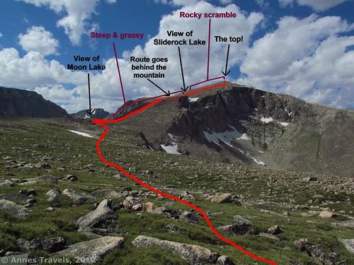
The non-existent trail up Mt. Rearguard 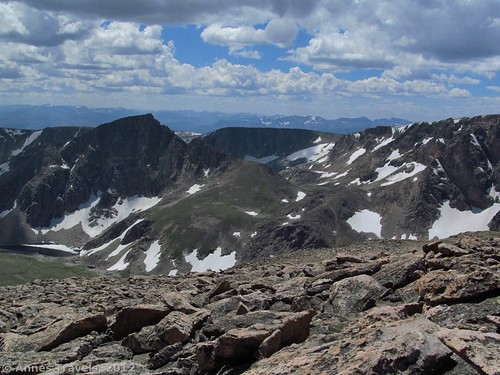
Part of the view from the top of Mt. Rearguard - Mount Rearguard. Of course, this list couldn’t be complete without at least one mountaintop in it. Mount Rearguard is one of those hikes that offers stunning scenery – and stunning solitude – for those with an adventurous side to them, steady ankles, and a high-clearance, 4×4 vehicle. Because the price to pay is a high one…the road to the trailhead (at the treeline) is long and rough, the trail, such as it is, disappears about halfway to the mountain, and the mountain climb itself is exceedingly steep and rocky at the top – bouldering skills required! But the reward of views over massive cliffs, idyllic lakes, and grassy tundra is more than worth the effort!
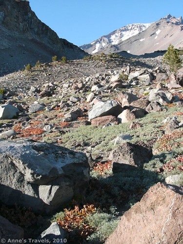
Hiking the easy part of the Green Butte Trail 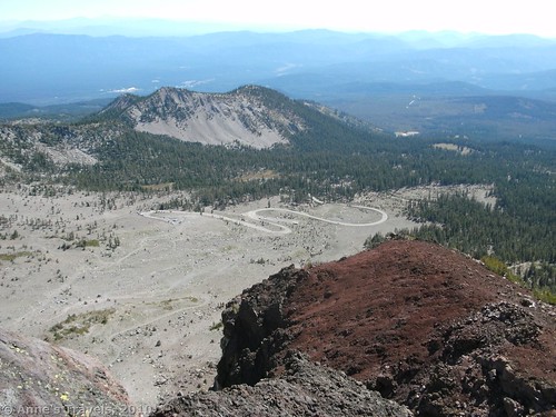
Looking down at the parking area from Green Butte - Green Butte. Did the description of Mt. Rearguard sound amazing, but you only have a Chevy Prizm? Not to worry! High on the side of Mt. Shasta in California, a paved road leads to a parking area from which you can climb up to Green Butte which (so I hear) is the highest point you can go on Mt. Shasta without technical climbing gear. The view maybe isn’t quite as good – and you’ll definitely have company on the lower sections of the trail – but once you reach the Ski Bowl and begin, on hands and knees, to climb the scree slopes toward Green Butte, you’ll be alone in this wild and rugged landscape.
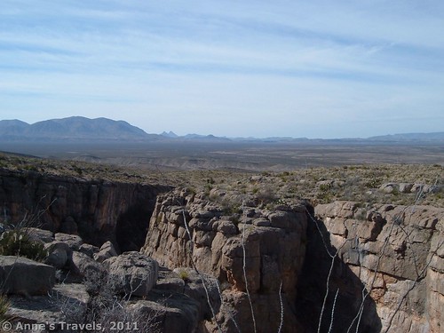
Views over the top of the Den 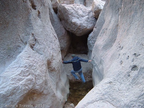
Trying to circumvent puddles…without getting our feet wet! - The Den. Exploring The Den in Big Bend National Park, Texas, isn’t so hard, it’s avoiding the water that’s difficult. Potholes have filled with water from the last storm, and chimneying your way over them so you can scramble up a 5ft. dryfall to the next level of the slot canyon is a sure way to make a hike more interesting! Add to this that the trail is, um, sort of followable will make for a hike you won’t forget too soon.
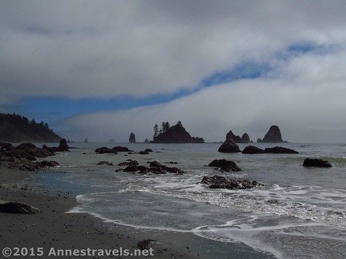
Views from the Third Beach to Strawberry Point hike 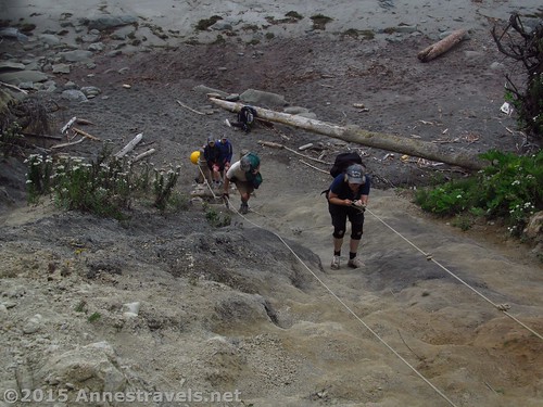
…And that’s the trail! - Third Beach to Strawberry Point. Ever scrambled up a steep slope and wished you had a rope to help you climb up? Along the Pacific Coast in Olympic National Park, the park service has conveniently left the ropes there for you so you can cross headlands in safety if not comfort. The section from Third Beach to Strawberry Point has two such headlands, which might or might not be scalable without the rope, along with ladders, tree trunks, and other more “natural” aids to help you navigate the steep slopes of the headlands and the deep mud along the tops of the highlands. Is there a reason this one came out near the top of our “favorites” list the last time we hiked it?
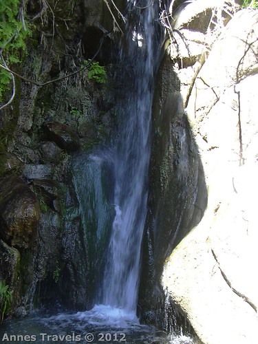
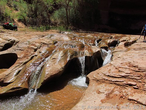
Maidenhair Falls 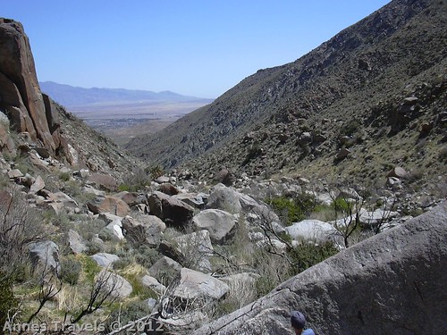
The canyon you’ll have to hike up to get there! - Maidenhair Falls. Deep in the desert of Anza-Borrego Desert State Park in southern California is a little waterfall. Really, it can’t be much more than 10 ft. tall – which I suppose is rather impressive in the desert – but the trail gives ample opportunity to the adventurer. The trail peters out less than halfway to the falls, with multiple social trails to lead you maybe-to-the-falls-someday, or maybe-just-to-end-at-a-cliff-face. You probably will have to scramble up and over boulders and rocks – again, hands and knees are helpful – but to dunk you head under the falls on a hot day is at nice reward before scrambling back down all those rocks to the parking area.
Waterfalls in Coyote Gulch 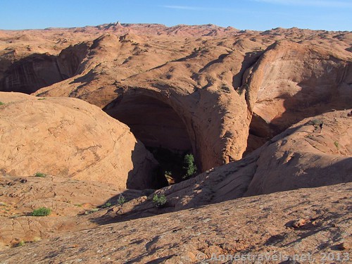
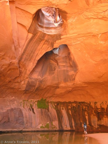
…but to get there, you’ll have to climb down from here into the canyon…no, ropes aren’t required 🙂 - Coyote Gulch. And now for a hike where the trail is the water-filled streambed. Yep, you heard that right. After crossing a wild and rugged space of the Utah desert and slickrock (no trail at all), and scrambling down a 45 degree angled cliff face (no ropes required, though) you’ll find yourself in a canyon with a little stream running through it. Around the corner is a huge, towering arch – worth the hike in itself! But for an even greater adventure, walk downstream in the ankle-deep river for a mile or more to waterfalls and another natural bridge!
What’s your favorite adventurous hike?
Zoom map in to browse individual hikes
This Week’s Featured Product!
Looking for even more trails off the beaten path? Check out this guide to Wyoming that covers both well-known and some rather unknown hikes.