

Hiking any trail can have its frightful aspects – walking away from civilization and the comfort of your car and into the unknown wilds of who-knows-where (not to mention scary stuff like spiders, snakes, bears, wolves, and sheer drop-offs). But some trails are over-the-top; the risk worth the danger to see or experience something truly unique. For your own set of my favorite – i.e, some of the most scenic – terrifying trails, check out these below – they’re not necessarily your average hikes.
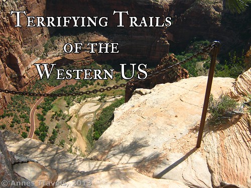
15 Terrifying Trails of the Western US
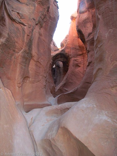
Peek-a-Boo Slot / Spooky Slot Loop, Grand Staircase-Escalante National Monument, Utah. The name enough should say that this isn’t for the faint of heart. But let’s start by saying that the #1 reason to avoid slot canyons altogether is that, should a flash flood come along, you’re toast. Add to this that to get between the two slots and complete the trail as a loop, you have to follow a vaguely marked trail across the barren desert, then descend through an ever-more-dangerous choke stone. Still, the uniquely shaped arches of Peek-a-Boo and the colorful, claustrophobic walls of Spooky are enough to make hundreds of visitors return year after year to experience its beauty… and risks. 3.5 miles RT.

Kootenai Swing Bridge, Kootenai County Park, Montana. There’s nothing really dangerous about the swing bridge, but just try telling yourself that while gingerly tiptoeing across its swaying 210ft. length at over 100ft. above the raging waters of the Kootenai River. This isn’t for anyone with a fear of heights, or the faint of heart, for sure. For a slightly less terrifying option, check out the nearby Kootenai Falls, one of the largest free-flowing waterfalls in the Northwest. About 1.5 miles RT.
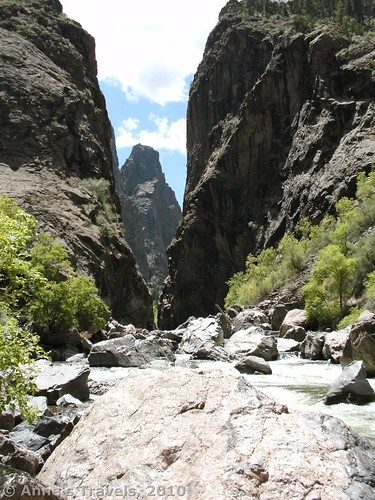
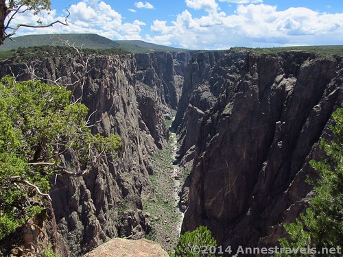
Long Draw, Black Canyon of the Gunnison National Park, Colorado. Imagine yourself scrambling down a rocky chute, towering cliffs on either side, just enough vegetation to hamper your climb, with the rapids of the Colorado River below, and hikers above sending showers of rocks and debris down on you. Such is Long Draw, though the views at the bottom make the trailless scramble make up for some of the danger of bruises and tumbles. Its conditions still wouldn’t be the first place I’d want to hike. About 3 miles RT.
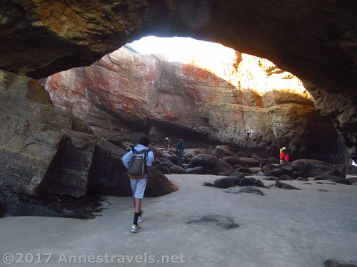
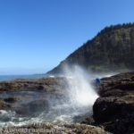
The Punchbowl, Devil’s Punchbowl State Park, Oregon. It has been said that time and tide wait for no man, and The Punchbowl is one place you wouldn’t want to be caught by the tide. At low tide, the rocky bowl with two sea-arch entrances is filled with tide pools and tourists scrambling around for a better look. At high tide, the bowl fills with several feet of water, crashing, churning, and icily cold, and even the nearby beach is under the sea. No, you definitely don’t want to be caught here. About 2 miles RT.
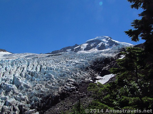
Heliotrope Divide Trail, Mt. Baker Wilderness, Washington. With four rushing stream crossings up to thigh deep – or deeper during spring snowmelt – this trail is a force to be reckoned with. The views of the glacier at the end are other-worldly; something you’d expect to see on the Discovery Channel. But don’t try to actually walk out on the snow and ice: If the razor-sharp rocks don’t send you back before you get there, one false step on the glacier could send you plummeting into a crevasse. 6.5 miles RT.
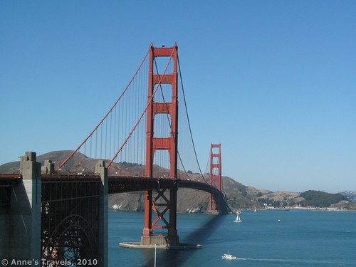
Golden Gate Bridge, San Francisco, California. While certain safety railings have been put in place, walking the pedestrian pathway between the stream of racing traffic and the 500ft. drop to San Francisco Bay is terrifying to say the least. Still, the views are pretty good, and the bragging rights to say that you’ve walked the 1.5 mile bridge – each direction – are worth the dizzying sensation from carbon monoxide and vertigo. About 3 miles RT. For a shorter option, check out Washington’s Deception Pass Bridge – a 3-foot-wide walkway and a wire-and-post fence is all that separates you from the waters of Deception Pass and logging trucks. 1.5 miles RT.
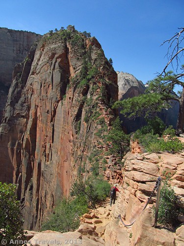
Angel’s Landing, Zion National Park, Utah. By far the most dangerous hike I’ve ever done, Angel’s Landing is enough to give those who love heights a touch of vertigo. A 2-foot-wide ledge on the rock face – and no railings – is the route that will take you to the top of the monolith, soaring 1,500ft. above the canyon floor. Go on a holiday weekend, and you’ll be clinging to the rock face in a “wider” spot, waiting for hordes of other hikers to pass so you can traverse the next section. Considering the danger, it’s surprising just how few deaths have taken place on the monolith’s slopes. 5.0 miles RT.
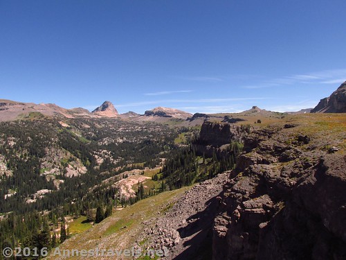
Alaska Basin Overlook, Jedediah Smith Wilderness, Wyoming. The overlook, while it has no guardrails and boasts quite the drop into Alaska Basin proper, isn’t really that terrifying, assuming you stay away from the edge. What makes this trail questionable is the active bear populations – and considering the hikers with their prominent cans of bear spray, even the natives take this peril seriously. Now, I’ve never seen a bear in the area, but that doesn’t mean there wasn’t one behind that bush, or the other one… About 11 miles RT.

Golden Dome Cave, Lava Beds National Monument, California. The first hazard is the roof while climbing down the metal grate stairway into the cave: I won’t say I was the first (or last) visitor with a bruise on my head. Once inside, the cave is a figure eight, adding adventure and uncertainty to experienced cavers and confusion and trepidation to those without a terrific sense of direction – I’ve watched people walk in circles, totally lost until one of us offered them helpful advice as to which fork to take. About 0.5 miles RT.
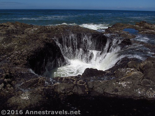
Thor’s Well / Cape Perpetua, Oregon. Thor’s Well is the remnants of an old sea cave, part of which collapsed. At high tide, the water rushes in from below, spouting up in gushing waves in the middle of an ancient lava flow filled with tide pools. Don’t get too close to the Well – those waves will take you away if given a chance, especially in stormy weather – but also don’t get too close to the edge of the lava flow: “sneaker waves” are a far too common way to ruin a vacation. Less than 3 miles RT.
Exclamation Point, Black Canyon of the Gunnison, Colorado. You won’t be tempted to get too near the edge of Exclamation Point. You might be too busy exclaiming, or you might just be at a loss for words at the sheer drop into the canyon without any form of guardrail. Still, the views rival all others in the park and many in other national parks across the US, even if you are breathless from vertigo. About 1 mile RT.
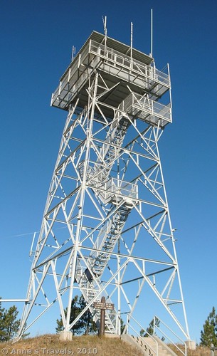
Warren Peak Fire Lookout, Wyoming. Situated next to the world’s only nuclear radar station, the lookout is only 50ft. high, but its metal grate stairway is nothing to sneeze at: “don’t look down” may be the mantra, but you’ll have to look down – likely all the way to the ground, through the stairs – if you don’t want to lose your footing on the uneven stairway. And believe me, looking through the stairs from 50ft. up, then having to step off your firm footing to another stair, is no joke.
Beacon Rock, Washington. Dozens of tight catwalks switchback wind their way up Beacon Rock, an old volcanic plug along the Columbia River in Washington. Hug the inside of the trail and you’ll be fine – until courtesy would dictate being on the outside, next to the railings overhanging the trail below. Fun… if you happen to like heights. 2.2 miles RT.

Coyote Gulch, Grand Staircase-Escalante National Monument, Utah. Strike off on an unmarked trail – no wait, there is no trail – across the desert and slickrock, then scramble down a near-vertical cliff (sans ropes) into a canyon that could experience a flash flood at any moment (how else do you think the arches and natural bridges were formed?) Sound a little exciting? Now try climbing back up that vertical wall and finding your way back to your vehicle… 4+ miles RT.
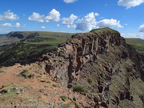
The Causeway, Flat Tops Wilderness, Colorado. If you really want to experience vertigo – or terror – head up the trail by Stillwater Reservoir to cross the Causeway. A 3-foot-rib of uneven crumbling rock connects two sections of rolling grasslands – with 500ft. cliffs on either side. There’s no need for your imagination to come up with the peril of this trail; it’s real enough for even the sanest mind. 6.0 to 9.5+ miles RT.
What are your favorite terrifying trails?
Zoom map in to browse individual hikes
More Related Posts:
 12 Epic Hikes in the Western US, Pt. 2
 Sneak Peak: A California Trip through Desert and Snow
 11 Amazing Trails of the West that are 1 Mile (or Less) in Length
 12 Trails that Require Hands & Knees, River Crossings, and Other Adventures
 10 Places to Go Exploring in the Western US
 Sneak Peak: A Land of Volcanos and Oceans