
Once upon a time, we were driving away from cloudy, rainy weather in Glacier National Park. In that once-upon-a-time world, we stopped at a wayside parking lot along US-2 west of Libby, Montana, to get out lunch and discovered a beautiful waterfall and a really fun swinging bridge across a raging river. That was the first time we visited Kootenai Park, but it’s not the last. In fact, we visited twice on our trip to Montana last summer (it happened to be a convenient place to make supper even if there aren’t much in the way of picnic tables). They have replaced the old swinging bridge from the 1950s, but otherwise, it’s still the same great place to stop if you happen to be traveling US-2!
Quick Stats

It would have been nice if we could have taken our time, but there were places we needed to be. So we were in a bit of a hurry. A couple of us ran down the trail while the others made dinner and/or lazed around the van in the parking area. (Who’d want to do that when they could see a waterfall and go crazily swinging across a gorge? Oh well, they got their chance later.) A paved trail leads to an overlook of the trees (seriously – if it’s ever going to be an overlook again, some brush is going to need to be cleared).

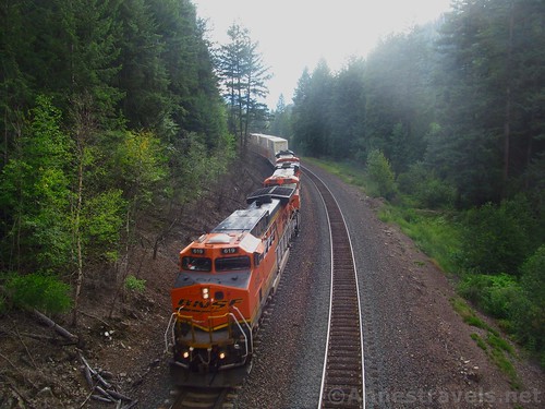
Turn left from the overlook and start down the very, very steep trail. It switchbacks, which is good. Some people have cut one of the switchbacks, but don’t bother taking it – the trail is better and it takes you to the same place. At the bottom of the switchbacks, a sturdy concrete bridge takes you high over the railroad tracks. As we stepped onto the bridge, my companion, who’s partially deaf, said, “I feel something.” A few seconds later, I felt the bridge begin to shake – a train was coming! I hadn’t dared to hope that I’d actually see a train go under the bridge!

As you can see from the photos, the line is owned by the Burlington & Santa Fe Railroad. We even looked up the train data to see when the locomotives had last been serviced, when they were added to the BNSF fleet, and any other interesting information from railfanners. If you happen to be on the bridge, be sure to wave to the engineer (they’ll probably blow their horn for you!) and stand directly over the track so you can feel the diesel exhaust and be dizzied by the cars going under you. So fun!
The train finally disappeared around the bend and we continued across the bridge and down the steep, spiraling stairs to the forest below. You’ve now descended most of the elevation you’ll descend on this trail, so you can look forward to a slightly easier path.

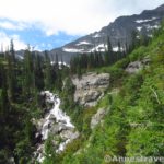
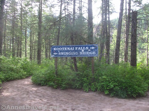
A short distance beyond the bridge, at about mile 0.3, the trail splits: right toward the waterfall and left toward the swinging bridge. We turned right toward the waterfall first – there is a slight scramble necessary to reach the rocks from which you can see the waterfall across the Kootenai River.
I’d forgotten just how nice the waterfall is (childhood memories of swinging bridges being stronger than a juvenile love for waterfalls). Some people take a picnic down here and make a day of it.

We took our photos and went back to the trail split to turn toward the Swinging Bridge. It’s quite a bit further – 0.3 miles – to the swinging bridge vs. 0.15 miles to the waterfalls from the trail split (one way distances). The trail is tangled with twisted roots and it’s very worn, so watch your step. You can also hear (though likely not see) any trains that go along the tracks seemingly above your head.

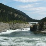
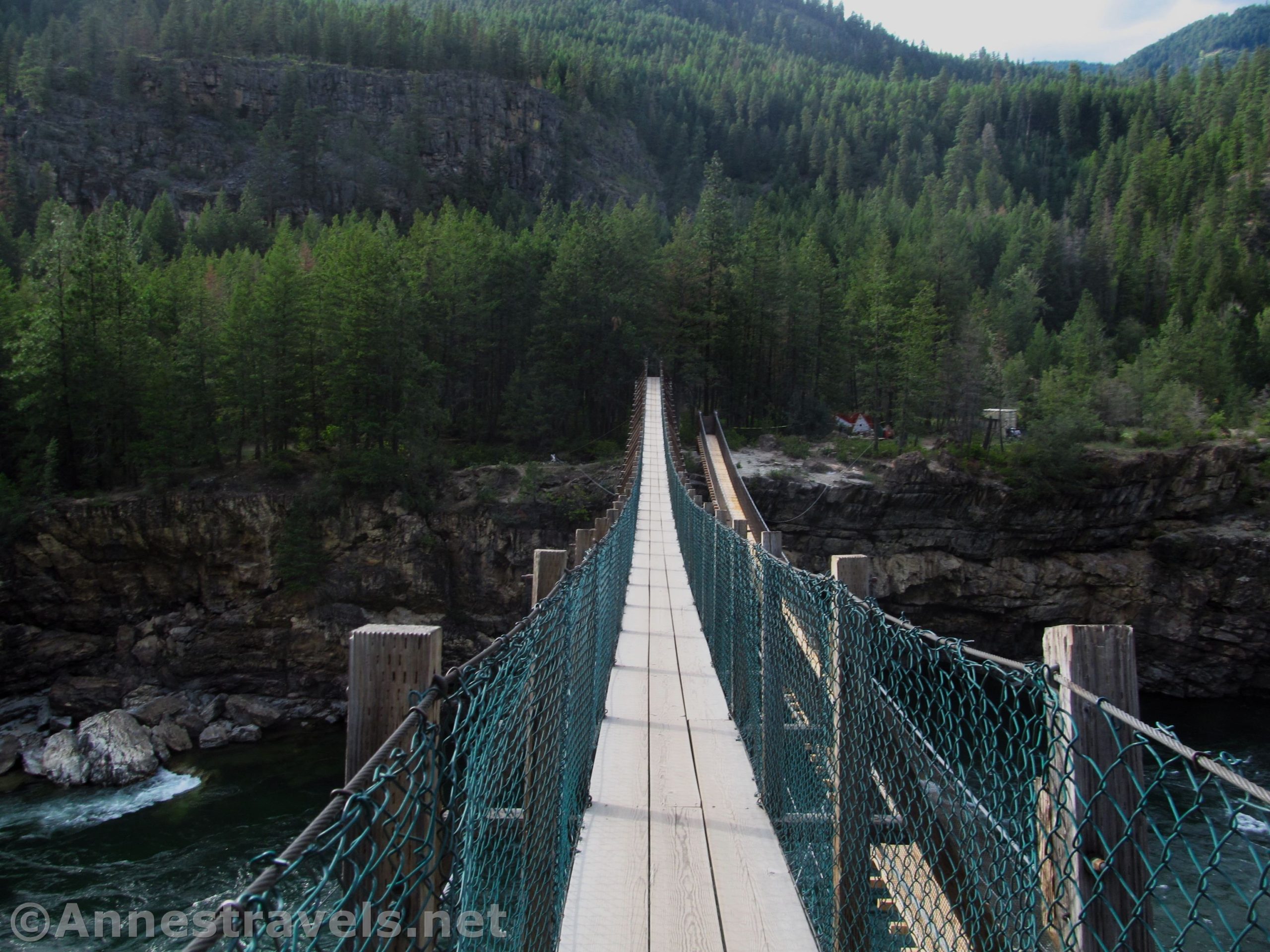
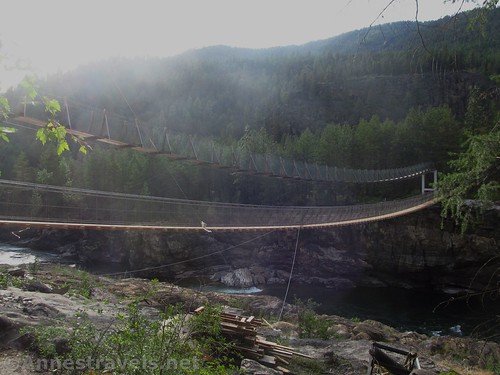
When we arrived at the swinging bridge, we were in for a little bit of a shock: The powers-that-be were in the process of building a new swinging bridge. Usage has increased in recent years and it was cheaper to make a new bridge rather than make the old one safer. However, it wasn’t open yet, so we walked across the old bridge and looked down on the new one.

I’d guess the new bridge won’t swing quite as much as the old one (those are pretty massive cables), but you’ll still get great views over the Kootenai River. The first bridge was constructed in 1937, but it was destroyed by a flood in 1940. The old bridge was built in the 1950s, but constant maintenance has been required. A 5-hiker limit was posted in 1980. Personally? We try to only have one or two hikers on the bridge at a time!

If you go over to the other side, you can walk/scramble down to where a small stream empties into the Kootenai River. The views of the waterfalls from here are very good, but we were in a hurry so we didn’t visit that day.

In fact, we took so much time already that we turned around and there was the rest of the group coming to find out where we’d disappeared to. They’d already made supper and were ready to keep driving. I wasn’t sorry we’d taken so much time – they got to walk across the swinging bridge (which they did enjoy).

We hiked back up to the parking lot (those switchbacks are no picnic!) in time to use the restrooms and continue on our way. But I wasn’t sorry we’d taken the time to hike it once again. The area is beautiful!

Round Trip Trail Length: With the train bridge, waterfalls, and to the end of the swinging bridge and back, I ended at just over 1.5 miles
Elevation Change: About 275ft. (2,153ft. at the trailhead to 1,980ft. at the falls)
Facilities: Pit toilets at the trailhead (can be busy since there’s one stall for ladies and one for men); snack shop at the trailhead (at least sometimes!)
Fees: None
Trail Notes: The trail isn’t difficult for a hiker, but it’s also not a stroll in the park. There are steep switchbacks, stairs, minor scrambling, and roots. I recommend sturdy hiking shoes. Also realize that the swinging bridge is not really for those who are afraid of heights… it does swing a bit when you walk on it!

Trail 
![]()
![]()
Road
Signs ![]()
Scenery ![]()
Would I go 100 miles out of my way for this? ![]()
Overall Rating: ![]()

GPS Coordinates for Kootenai Falls & Swinging Bridge
Trailhead: 48.4527333°, -115.7690000° (N48° 27.164′ W115° 46.140′ / 48°27’09.8400″, -115°46’08.4000″) (2,153ft.) (0.0) (end 1.54)
Overlook Junction: 48.4533833°, -115.7671667° (N48° 27.203′ W115° 46.030′ / 48°27’12.1800″, -115°46’01.8000″) (2,080ft.)
Falls vs. Bridge Trail Junction: 48.4545667°, -115.7681667° (N48° 27.274′ W115° 46.090′ / 48°27’16.4400″, -115°46’05.4000″) (1,997ft.) (0.30) (Return 0.63)
Kootenai Falls Viewing Area: 48.4546833°, -115.7651833° (N48° 27.281′ W115° 45.911′ / 48°27’16.8600″, -115°45’54.6600″) (1,980ft.) (0.46)
Swinging Bridge: 48.4529000°, -115.7713500° (N48° 27.174′ W115° 46.281′ / 48°27’10.4400″, -115°46’16.8600″) (1,977ft.) (0.90)
The gpx file for Kootenai Falls & Swinging Bridge can be downloaded – please note that this and the GPS Coordinates are for reference only and should not be used as a sole resource when hiking this trail.
Download GPX File size: 26.9 KB Downloaded 445 times
(Note: I do my best to ensure that all downloads, the webpage, etc. are virus-free and accurate; however, I cannot be held responsible for any damage that might result, including but not limited to loss of data, damages to hardware, harm to users, from use of files, information, etc. from this website. Thanks!)
Getting to Kootenai Falls & Swinging Bridge
From Libby, Montana, drive west on US-2W. After 11 miles, turn right into the large (but often crowded) parking area for Kootenai County Park. A sign in the parking area points toward Kootenai Falls and the Swinging Bridge.
From Sandpoint, Idaho, drive north on US-2E/US-95N. After 34 miles, turn right to stay on US-2E (US-95N continues to Canada – we missed the turn a few days later and almost ended up having to use our passports!) Drive on US-2 for 36.7 miles to Kootenai County Park, on left. The parking area is large but often crowded (turnover is fairly high). A sign in the parking area points toward Kootenai Falls and the Swinging Bridge.

This Week’s Featured Product!
If you want more hikes in the area around Kootenai Falls, this book is a great resource. It covers the nearby Cabinet Mountain Wilderness as well as several national forests and Glacier National Park.