

While researching trails to hike in the Cabinet Mountains Wilderness in western Montana last spring, I discovered a couple of things: 1) While there are many trails in the Cabinets, you can’t find good information about most of them, and 2) There are a few trails that most people seem to hike and therefore you can find at least a little bit of information about these few. One of the more-informed hikes I found (besides Leigh Lake) was the trail to Wanless Lake. Eighteen miles to see a lake seemed a little excessive as a day hike to me, but at least one blogger mentioned Goat Peak as an alternative side-trek en route to the lake. A peak is almost always more interesting than the lake for a view junkie like me, and since it was only 13 miles RT, it seemed a much better option.
Quick Stats
(Affiliate links are present on this page.)

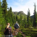
We did Goat Peak as a long day hike. The morning was cool and the dew still on the grass. We were the only people (as far as we could tell) on the trail, which was a bit of a relief after our hikes in Glacier National Park the week before. We eventually saw three or four other people, but most of those were in the parking area.

Sign in at the trailhead kiosk not far from the trailhead. Any important information will be posted here – if you have stock, be sure to follow the guidelines posted. As with any other hike into the wilderness, use common sense and come prepared!

From the first, the trail climbs through the forest, and that’s the trail in a nutshell. The first switchbacks are the steepest, and the lower forest the deepest, but you’re going to be puffing while seeing a lot of trees on this hike. It’s a good thing the view at the end is pretty good, or I wouldn’t consider it a very worthwhile trek.
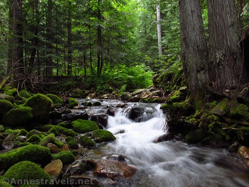
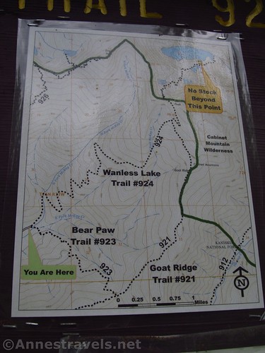
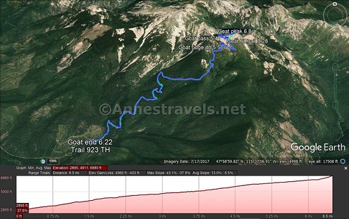
The trail crosses a pretty McKay Creek, then rises out of the valley and up the hillside. By the time the Wanless Lake Trail meets the Goat Ridge Trail at mile 5.5, the forest has thinned to be meadows with pines that block the view.

(The Goat Ridge Trail offers a loop option to return to the parking area – turn onto the Goat Ridge Trail, then turn right on the Bear Paw Trail #923 after 3 or so miles. Take the Bear Paw Trail down to where it crosses the river just before the parking area. It’s slightly longer than the Wanless Lake Trail but probably by no more than a mile or so.)
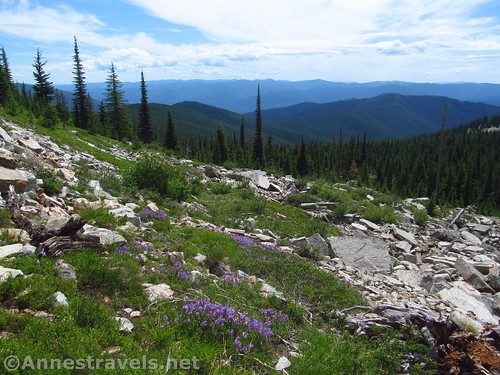
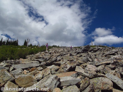
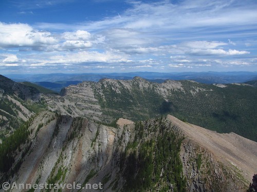
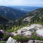
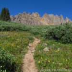
Shortly after the Goat Ridge Trail branches right, the path will break out of the trees into open meadows and scree slopes. It’s the “wow” factor after all that forest to suddenly see the valley spread out below and the mountains beyond!
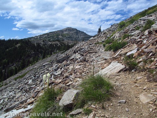
If you want to cut the trail shorter (probably 0.5 miles shorter RT), once you reach the scree slopes, turn right up to the high point (Goat Peak). I wanted to go to the pass, so I continued on the trail to the pass, but returned by scrambling straight down the scree to the trail (more on that later).
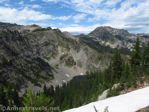
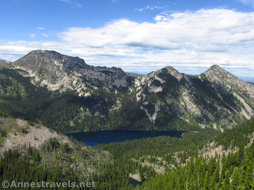
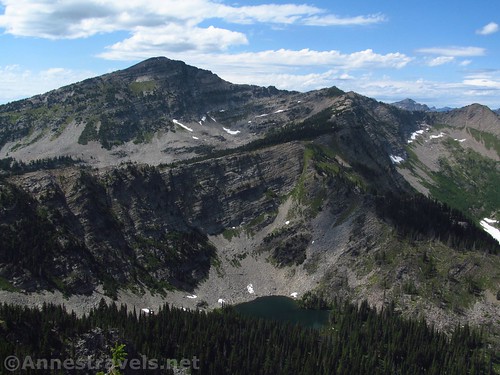
At about 6.4 miles, the trail turns suddenly to go through a pass and descend the other side of Goat Peak (this marks the Cabinet Mountains Wilderness Boundary). I stopped here in the pass (in part because the trail after this crossed a snowfield – and it was mid-July), and some of my group enjoyed the view and then went back down the trail. The view really is good here; it would be worth coming this far even if you don’t plan to hike Goat Peak. On the south (west) side of the pass is the views of the valley, but on the north side, you can see one of the unnamed lakes the Wanless Lake Trail passes (if you hiked down the other side of the pass) and Flat Top Mountain. It’s a beautiful sight.
Here I turned right and began scrambling up the scree. There are a fair number of bushes and trees to avoid on this route, but it’s not a big deal. Just stay right rather than left – there are sheer cliffs on the left (north) side of Goat Peak.

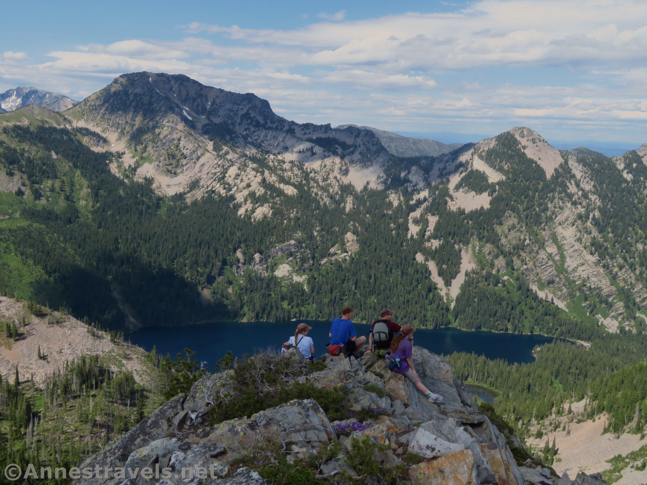
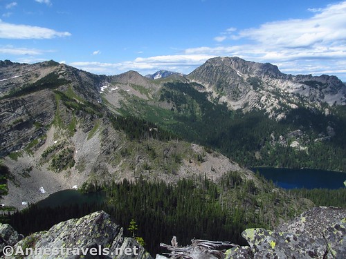
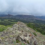
About 0.3 miles from the pass, arrive at the top of Goat Peak. The view is great from here, but we scrambled down the north side of the peak to an outcrop of rock where the view was even better. Engle Peak, Flat Top Mountain, Wanless Lake, Carney Peak, Lost Buck Pass, and views beyond and around to a number of unnamed peaks. So beautiful!
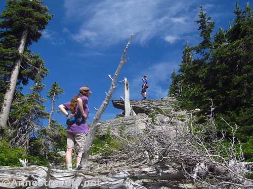
We were running late on time (besides being long, the trail had been steeper than we had anticipated), so we didn’t spend as much time as the view would have warranted. But the day was moving on and clouds were moving in. So instead of going back to the pass, we just scrambled down the scree slopes to the trail.

Overall? A very steep, woodsy hike to some great views. If you lived in the area, this would be a fantastic day hike. This Easterner felt it was a little bit too much pain for gain – but then again, I was also comparing it to Glacier… and it’s really hard to compare with Glacier’s scenery!

Round Trip Trail Length: 13.0 miles to 13.6 miles depending on your route up Goat Peak
Elevation Gain: 4,763ft. (2,895ft. to 6,880ft.)
Facilities: Questionable hitch rail in the parking area
Fees: None
Trail Notes: The stream near the trailhead is beautiful. Be sure not to be up on the exposed peak if thundershowers threaten. You may want to wear long pants as bushes sometimes overhang the trail. This is one of the most popular trails in the Cabinet Mountains, so be ready to share it with a half dozen to a dozen other people on summer weekends.
Trail 
![]()
![]()
![]()
Road ![]()
![]()
Signs ![]()
![]()
Scenery ![]()
Would I go 100 miles out of my way for this? ![]()
Overall Rating: ![]()
![]()
GPS Coordinates for Goat Peak
Wanless Lake/Goat Peak Trailhead: 47.9707667°, -115.6429167° (N47° 58.246′ W115° 38.575′ / 47°58’14.7600″, -115°38’34.5000″) (2,963ft.) (0.0) (end 6.22 add 6.8 from trek out)
Goat Ridge Junction: 47.9950667°, -115.6003167° (N47° 59.704′ W115° 36.019′ / 47°59’42.2400″, -115°36’01.1400″) (6,107ft.) (5.5) (return 0.95; probably meant 0.55)
Pass: 47.9988167°, -115.6004833° (N47° 59.929′ W115° 36.029′ / 47°59’55.7400″, -115°36’01.7400″) (6,412ft.) (5.4 probably meant 6.4)
Goat Peak: 47.9986167°, -115.5946000° (N47° 59.917′ W115° 35.676′ / 47°59’55.0200″, -115°35’40.5600″) (6,869ft.) (6.8)
Regain Trail from Goat Peak: 47.9970667°, -115.5981833° (N47° 59.824′ W115° 35.891′ / 47°59’49.4400″, -115°35’53.4600″) (6,405ft.) (0.28)
(Trail 923 (Bear Paw) Trailhead: 47.9703833°, -115.6427333° (N47° 58.223′ W115° 38.564′ / 47°58’13.3800″, -115°38’33.8400″) (2,966ft.) – Not the TH for Goat Peak)
The gpx file for Goat Peak via the Wanless Lake Trail can be downloaded – please note that this and the GPS Coordinates are for reference only and should not be used as a sole resource when hiking this trail.
Trail out:
Download GPX File size: 118.1 KB Downloaded 414 times
Trail back:
Download GPX File size: 104.7 KB Downloaded 458 times
(Note: I do my best to ensure that all downloads, the webpage, etc. are virus-free and accurate; however, I cannot be held responsible for any damage that might result, including but not limited to loss of data, damages to hardware, harm to users, from use of files, information, etc. from this website. Thanks!)
Getting to the Goat Peak Trailhead/Wanless Lake Trailhead
From Sandpoint, Idaho, take US-2 to the place where US-2 and US-95 merge. Instead of following US-2 and US-95, continue straight on ID-200. Continue 33.2 miles to where the road enters Montana and becomes MT-200E and drive another 18.4 miles. Turn left onto the dirt McKay Creek Road (a sign will point right toward Noxon Rapids Dam). The road is rough but probably passable to passenger cars at least up to the near side of the trailhead, about 4 miles from the main road. (Note: A few roads and “roads” go off of the main road, but it’s pretty easy to tell which one is the maintained road for cars!)
From Thompson Falls, Idaho, take MT-200W 32 miles. Turn right onto the dirt McKay Creek Road (a sign will point right toward Noxon Rapids Dam). The road is rough but probably passable to passenger cars at least up to the near side of the trailhead, about 4 miles from the main road. (Note: A few roads and “roads” go off of the main road, but it’s pretty easy to tell which one is the maintained road for cars!)
Zoom map out to browse nearby hikes & places of interest
This Week’s Featured Product!
If you want to do justice to the trails of the Cabinet Mountains Wilderness, you’ll need to purchase this book. It lists more than 100 hikes within the Wilderness – far more than you’ll find by searching the internet.


2 responses to “Climbing Goat Peak near Wanless Lake”
[…] from Goat Peak in the Cabinet Mountains Wilderness, […]
[…] next day we decided to hike what would be one of the hardest hikes on the trip: Goat Peak (via the Wanless Lake Trail). Yes, the elevation gain was difficult, but really, the strenuousness came from the lack of […]