

Leigh Lake is known as one of the premier hikes of the Cabinet Mountains Wilderness in far western Montana. That’s likely due to the fact that 1) you can get to the trailhead without 4×4, 2) the trail is only 3.1 miles RT, and 3) there’s a lot of beautiful scenery here. Despite all the positives, it does have a couple of drawbacks: 1) it can be crowded as the Cabinets go, and 2) the trail is steep – like extremely steep! So as long as you don’t come out here for a stroll in the park, you should have a great hike!
Quick Stats
(Affiliate links are present on this page.)

The trail begins at the end of the access road (note: GPSes don’t necessarily like this road, so follow the directions, not your GPS, to the trailhead). A table nearby made out of rocks was really neat. Shortly up the trail is the signboard where you are supposed to sign in – I would have signed in, but all the forms were used up and even all the backs of the forms had been used. So much for signing in!

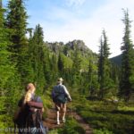
So we headed up the trail, entering the Cabinet Mountains Wilderness about mile 0.3. It looks like a nice, wooded stroll, but that steep section at the beginning is just whetting your appetite. The trail goes up and up and up! Except where it goes down, only to go right back up!
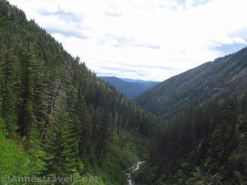
The path rises through the forest for about a mile, then enters a rock slide area. Be careful to follow the trail – if you can’t figure out where it goes, scout and find it because it is definitely there – you just have to locate it. The trail goes up a couple of strange switchbacks but keeps up its promise of steepness.

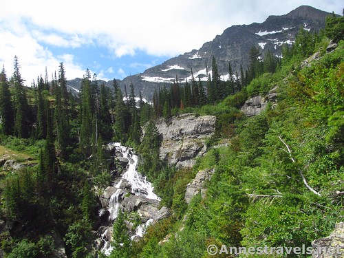
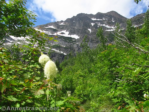
Not long after the rock scramble section (there isn’t too much scrambling involved here), you’ll begin to see the waterfall in the Leigh Lake Outlet. Since I haven’t been able to locate a name for the falls, I’ll call it Leigh Lake Falls.

About 1 mile from the trailhead, you’ll arrive at the base of the falls. It’s stunning! (And that coming from someone who lives in waterfall country!) Honestly, my favorite part of the hike was seeing the waterfall.

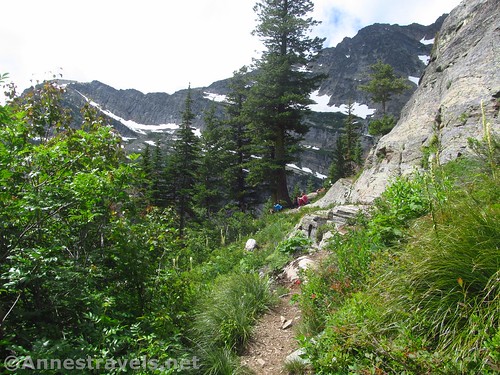
The trail turns here to go up a near-sheer cliff face. There is a trail, but you might find yourself using your hands now and then. Be sure to look back at the falls, which are spectacular from above, too.

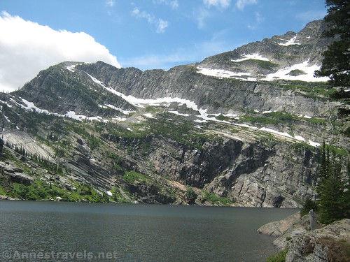
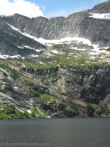
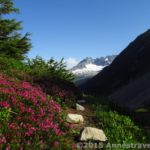
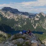
There are a couple more short scrambles (no trouble finding the trail here) before the trail finally begins its gentle descent through the scrub brush to Leigh Lake. Take in the lake from up here, since the views of the peaks and the lake are quite good from above (at least from a camera angle).

Reach the lake’s outlet at mile 1.5. The views aren’t great from here, so turn right to follow the social trails along the lakeshore. They go in multiple directions, including up (I hear you can climb Bockman Peak to the north if you don’t mind making your own trail up the scree). I stayed fairly close to the lakeshore and ended up on a point out into the lake about 0.05 miles from the lake outlet. So beautiful!

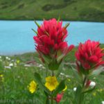
Unfortunately, most of our time at the lake was cloudy. Still, the sun poked its head through enough to get some nice photos.
Retrace your steps back to the parking area. It’s not a long hike, but the waterfall and the views over the lake make it well worth the time and effort to come out here!

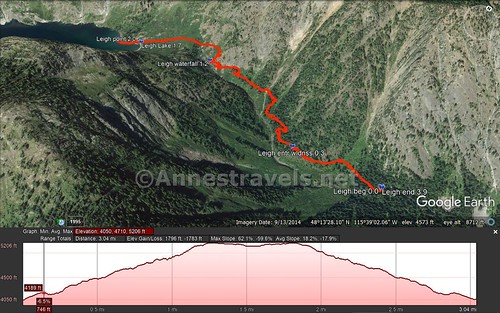
Round Trip Trail Length: 3.1 miles out & back
Vertical Elevation Change: 1,156ft. (4,050ft. at the trailhead to 5,206ft. above the lake)
Facilities: A primitive stone table for four at the trailhead
Fees: None
Trail Notes: The trail is popular with families on weekends. Be prepared to do a little scrambling (like, wear close-toed shoes). No stock is allowed on this trail. People do backpack in the area, though I’m not sure exactly where they camp. Group size is limited to 8 people (we made it – barely!)
Trail 
![]()
![]()
Road ![]()
Signs ![]()
![]()
![]()
Scenery ![]()
Would I go 100 miles out of my way for this? ![]()
Overall Rating: 
![]()

GPS Coordinates for Leigh Lake
Trailhead: 48.2245167°, -115.6411833° (N48° 13.471′ W115° 38.471′ / 48°13’28.2600″, -115°38’28.2600″) (4,004ft.) (0.0)
Enter Cabinet Mountains Wilderness: 48.2241333°, -115.6470000° (N48° 13.448′ W115° 38.820′ / 48°13’26.8800″, -115°38’49.2000″) (4,260ft.) (0.3)
Waterfall: 48.2258667°, -115.6553167° (N48° 13.552′ W115° 39.319′ / 48°13’33.1200″, -115°39’19.1400″) (4,897ft.) (1.2)
Leigh Lake: 48.2247167°, -115.6603500° (N48° 13.483′ W115° 39.621′ / 48°13’28.9800″, -115°39’37.2600″) (5,091ft.) (1.7)
Point: 48.2243667°, -115.6623167° (N48° 13.462′ W115° 39.739′ / 48°13’27.7200″, -115°39’44.3400″) (5,116ft.) (2.0)
End: (48.2245167°, -115.6411333° (N48° 13.471′ W115° 38.468′ / 48°13’28.2600″, -115°38’28.0800″) (4,097ft.) (3.9)
The gpx file for Leigh Lake can be downloaded – please note that this and the GPS Coordinates are for reference only and should not be used as a sole resource when hiking this trail.
Download GPX File size: 121.2 KB Downloaded 395 times
(Note: I do my best to ensure that all downloads, the webpage, etc. are virus-free and accurate; however, I cannot be held responsible for any damage that might result, including but not limited to loss of data, damages to hardware, harm to users, from use of files, information, etc. from this website. Thanks!)
Getting to Leigh Lake
From Libby, MT, head south on US-2E. After almost 8 miles, turn right onto Bear Creek Road (NF-278) for 3.0 miles. Turn right onto NF-867 for 4.5 miles, then turn right tonto NF-4786 and drive up to the parking area a little more than a mile up the road. There should be signs for Leigh Lake at the latter two junctions, though I’m convinced one of the signs was missing, which is part of how ended up on a dead-end dirt road with GPS telling us to drive straight through the forest!
From Kalispell, MT, drive west on US-2W for 80 miles. Turn left onto Bear Creek Road (NF-278) for 3.0 miles. Turn right onto NF-867 for 4.5 miles, then turn right tonto NF-4786 and drive up to the parking area a little more than a mile up the road. There should be signs for Leigh Lake at the latter two junctions; I think one might have been missing, and between that and an unhappy GPS, we ended up on a long detour that had us on one-way roads through the forest that didn’t go anywhere…
Zoom map out to browse nearby hikes & places of interest
This Week’s Featured Product!
This is the premier book about hiking in the Cabinet Mountains! From day hikes to multi-day excursions, this is likely the most complete book on the market for hiking the area.

2 responses to “Hiking the Cabinets’ Leigh Lake and Leigh Lake Falls”
[…] then there were the 3-mile trails, like Leigh Lake in Montana’s Cabinet Mountains […]
[…] to the Cabinet Mountain Wilderness between Glacier and the Idaho border. Our first hike was up to Leigh Lake. The sunshine didn’t cooperate over the lake, but the views of the falls below the lake were […]