
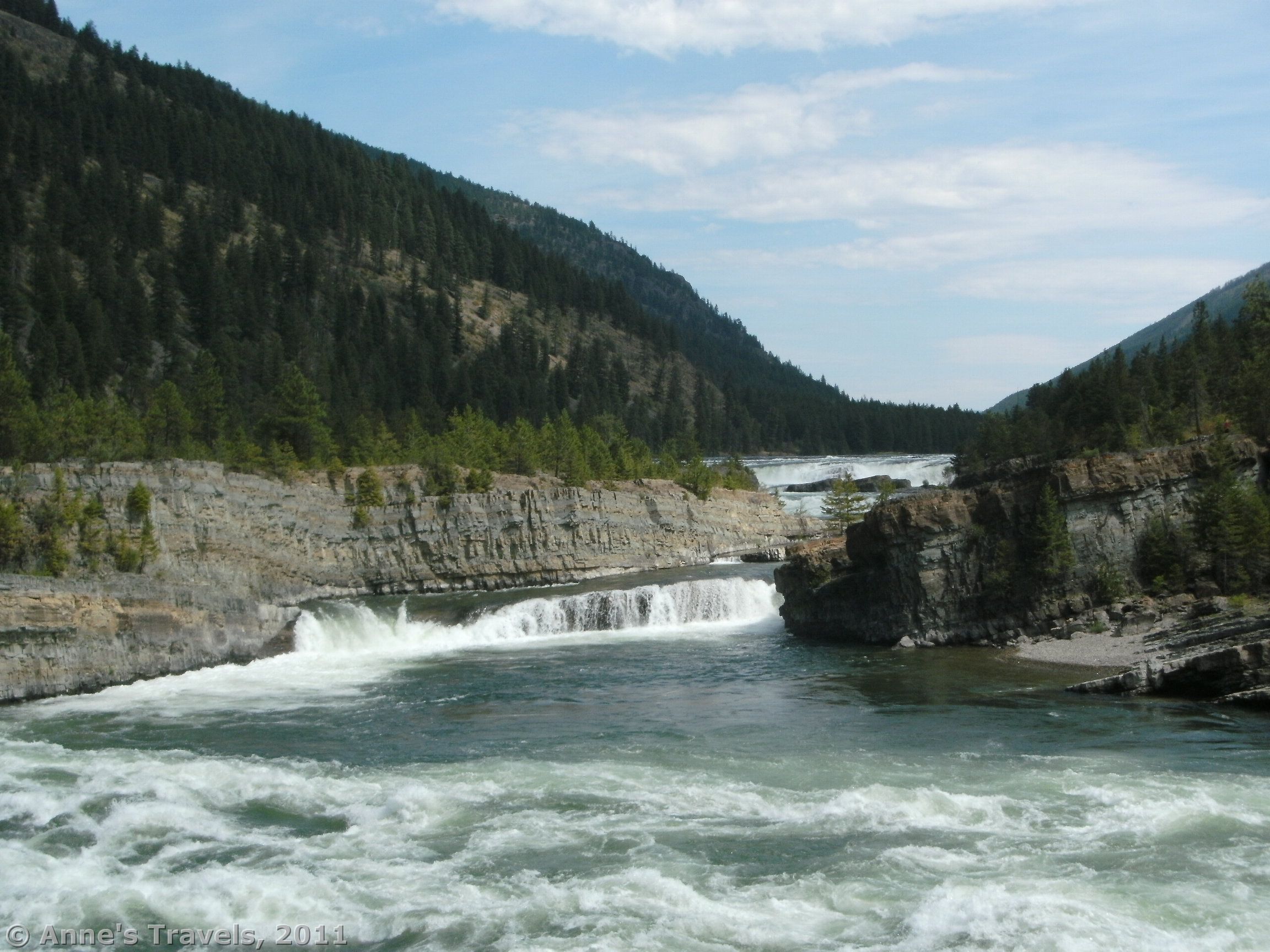

Several years ago, we were driving down a small highway in Montana looking for a place to eat lunch. A roadside sign that said “Kootenai Falls” caught our attention, so we pulled into the parking area. We were rewarded, too: at this tiny park we found a very impressive waterfall, as well as a cool swinging bridge. To get to either of these, though, you have to cross the railroad tracks via a huge concrete bridge. Because the track has trains going along it, it is fairly likely if you wait that you will be able to see one go right underneath your feet! Who knew that you could see something so cool in this section of western Montana? (Note: More accurate information from my more recent trip can be found .)
(Affiliate links are present on this page.)

A large sign at the eastern end of the parking area reads “Kootenai Falls County Park”. It then lists the rules of the park (no skateboarding, littering, fireworks, camping, etc.) and the organizations who helped to create the park. It’s quite the assortment, too: the Burlington Northern Railroad, Montana Department of Transportation, Lincoln County, Montana Department of Fish, Wildlife & Parks, the US Forest Service, and the Kootenai and Salish Indian Tribes! More information is located near this sign; head up the paved trail to get to the large kiosk. Slightly farther up the trail are two primitive restrooms. They worked, but were terribly smelly, so be forewarned! If you keep walking up the trail, you will come to the small picnic area. This area hasn’t been busy either time that we’ve been there.

To get to the falls and swing bridge, walk past the picnic area and down the stairs and gravel trail. Before long, you will come to the bridge over the train tracks (about 0.15 miles from the parking area). Really, this is more than a bridge: it’s an incredible monstrosity! It’s huge and concrete, and has stairs spiraling up to the walkway above the tracks. If you have the patience to wait, it is fairly likely that you will see a train. We saw one go right underneath us the first time we were there, and the second time we heard quite a few, and saw one, although we didn’t make it up onto the bridge itself before it had passed. We timed the trains, and, at least on that Sunday, the trains seemed to come every 45 minutes or so.
Cross the train tracks, and then you will come to a split in the trail with a huge blue sign. Left takes you to the swing bridge, while right takes you to the falls. I’ll take you to the falls first, because they’re easier to write about.

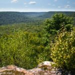
Take the right fork of the trail to get to the falls. The trail is fairly flat, although there are roots and rocks to be aware of. It is also well-worn, so it isn’t hard to follow. Actually, all the official trails in Kootenai Falls County Park look like they’ve seen far more use than they were intended to see. It’s not bad, but don’t expect this park to look like it’s usually deserted. It’s 0.14 miles from the trail junction to the viewing area for the falls, which is just a huge slab of rock that allows you to see the Kootenai River. There are no guard rails, so watch your step! The view of the falls from here is very nice, although an island in the middle of the river keeps you from being able to see the falls the entire way across the river.
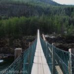
If you’re interested in the swing bridge (originally the only reason we took the trail—some of the members of my group are crazy about swing bridges!), go back to the trail junction. This time take the left fork. The trail here is not as flat, and is really quite rocky in some places. Be ready to walk over large jagged rocks. Again, this trail has obviously seen use. The trail itself wonders downhill from the trail junction, following the train tracks. It is about a quarter of a mile to the swing bridge. Personally, I think all of these mileages are a bit conservative; it’s probably a little longer than they say.

The bridge itself is very long for a swing bridge. I’m not sure how long exactly, but I’d guess that it’s at least 100 ft. You are also fairly high above the Kootenai River, so no jumping off of the bridge is allowed. One member of my group who dislikes swinging bridges wasn’t very happy its length, but even she made it. The younger ones, though, loved it and would have been happy to spend all afternoon romping from one end of the bridge to the other!
At the other end of the bridge, you have a choice. You can either return the way you came, or you can try to find a viewpoint of the falls on this side of the river. I don’t really recommend the second option, although I will tell you what we did. Done right, you can get an incredible view of the falls. Done wrong, you could end up seriously hurt or worse. So recognize, this isn’t a stroll in the park.

There are any number of social trails that you can follow back upriver. Try to keep somewhat close to the river itself as you follow a social trail in that direction. If these things don’t change, pretty soon you will come to a small stream which you will have to cross. At this point, we found a beach. From here you can’t actually see the falls, but some of the younger children had fun playing there. Be careful, though, as the Kootenai River is very swift and it would be easy to drown in it.
Keep walking upstream, scrambling up boulders, across logs, and through the forest until you can get up on a rock and see the falls. In many ways you get a better view here than you do from the falls viewpoint, but that’s up for dispute. You can also keep going up river to get an even better view of the falls, but here the “trail” goes across scree slopes high above the river. These can be quite dangerous and slippery, so be very careful. We decided we weren’t up to it, so we came back down. So, I don’t know how far you have to go to get a really, really good view of the falls from this vantage point.

Return by the way you came. This is a nice place to spend a day or an afternoon if you’re traveling west from Glacier National Park, or if you just in the area. We found we could drive from Glacier in the morning, eat lunch in the Kootenai picnic area, see the falls/bridge/watch a train and then either have supper in the picnic area or continue driving for a while before supper. But, take your time…it’s an awesome place to visit!
Round Trip Trail Length: 1.5 miles (approximate)
Fees: None
Trail 
![]()
Road
Signs
Scenery ![]()
Would I go 100 miles out of my way for this? ![]()
![]()
![]()
Overall Rating: ![]()
This Week’s Featured Product!
It’s hard to find trail guides to the Cabinet Mountains and the local region. But this book covers the area in great detail.
5 responses to “Kootenai Falls: Swing Bridge, Train Bridge, and Waterfalls!”
I’m not that much of a internet reader to be honest but your blogs really nice, keep it up! I’ll go ahead and bookmark your website to come back down the road. All the best
It’s a pity you don’t have a donate button! I’d definitely donate to this brilliant blog! I suppose for now i’ll settle for bookmarking and adding your RSS feed to my Google account. I look forward to brand new updates and will share this blog with my Facebook group. Chat soon!
I just want to say I am just all new to blogging and site-building and seriously enjoyed your web page. Very likely I’m likely to bookmark your blog . You definitely have remarkable article content. Regards for revealing your blog site.
[…] Kootenai Falls, Kootenai Falls County Park, Montana. Now here’s a really nice unknown waterfall. It’s definitely a local haunt, with a viewpoint over the Falls, a swing bridge to the other side of the river, and more social hiking opportunities to other views of the waterfall on the far side of the river. About 1.5 miles RT […]
[…] Kootenai Swing Bridge, Kootenai County Park, Montana. There’s nothing really dangerous about the swing bridge, but just try telling yourself that while gingerly tiptoeing across its swaying 210ft. length at over 100ft. above the raging waters of the Kootenai River. This isn’t for anyone with a fear of heights, or the faint of heart, for sure. For a slightly less terrifying option, check out the nearby Kootenai Falls, one of the largest free-flowing waterfalls in the Northwest. About 1.5 miles RT. […]