
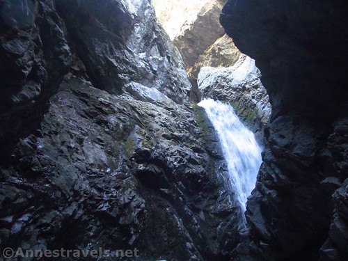
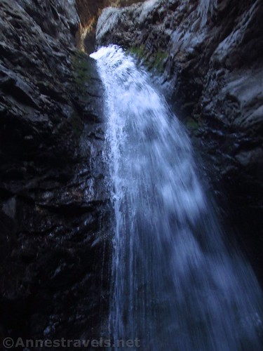
Looking up at the top of Zapata Falls
Zapata Falls is a very cool hike – well, the end is cool, both interesting and cold. It’s not a long hike, which makes it a haven for families, especially on hot summer days, but the trail up to the falls can be very warm on a hot day. The road up is also quite the adventure (I saw enough sedans do it, but I was very thankful for high clearance and wouldn’t have minded more robust tires), so it’s a lot of excitement for not too much pain in hiking. The falls are just outside Great Sand Dunes, making it a perfect afternoon adventure if the dunes get too hot for comfort in the afternoon sun.
Quick Stats
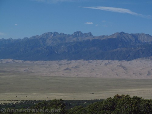
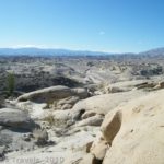
The sand dunes can get pretty hot in the afternoon, but they’re beautiful from above
We arrived in Great Sand Dunes one afternoon in late May, meaning that it was too hot to be out on the dunes (we had hoped the river would be flowing, but due to 25% snowpack the winter before, the river was long gone when it should have been in full force). I vaguely remembered hike a trail to a frigid canyon with a waterfall at the end, so we quick looked it up and then headed up to Zapata Falls.
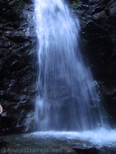
A picture of Zapata Falls that not only is very poor quality, but also gives no sense to the height of the falls
There is a lot of parking at the trailhead, but it’s pretty spread out, so you might have to walk a quarter mile to the trailhead. Still, on that May (weekend) afternoon, we drove around in a couple circles before we saw someone pulling out and took their parking spot (you’re not allowed to park on the edge of the road and the rangers do patrol it).
The view from the concrete viewpoint in the parking area is outstanding!
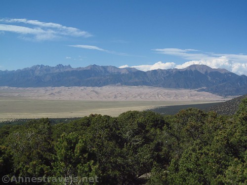
Be sure to check out the viewing platform in the parking area – the views over Great Sand Dunes and the peaks beyond are outstanding!
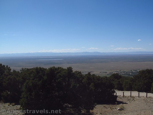
Near the trailhead – the views across the plains are pretty good, too
The trail itself is wide and easy to follow, well worn by previous hiker’s feet. At 0.35 miles, continue left (straight) when the S. Zapata Lake Trail goes off on the right. Otherwise, it’s very straightforward until you get to the stream, less than a tenth of a mile beyond the trail junction.
The lower part of the trail up Zapata Creek
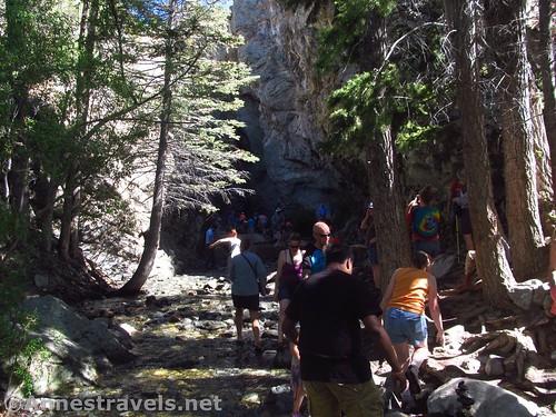
The wide trail ends at the edge of the creek. A few social trails go up the right side for a bit, but eventually, you’ll have to either wade in the stream or rock-hop. When I visited in April, we could rock-hop up to within a dozen feet or so of the falls (a good thing, because the entire canyon was absolutely frigid!) Late May with 25% snowpack and the river across the dunes disappearing the month before, we could rock-hop all the way to the falls (long legs an asset). I would expect most years in May, most of the rocks would be underwater and you would need to use extreme care in the deeper, faster-flowing water. If you don’t feel it’s safe, don’t do it.
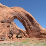
The last stretch to Zapata Falls
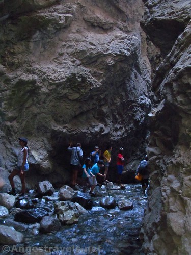
The sides of the canyon get higher over the river, then the canyon turns sharply to the left, looking a bit like a box canyon. At the end of the box, just to the right and out of sight unless you’re just about on top of it, is the waterfall.

Looking up, up, up to the canyon above the falls
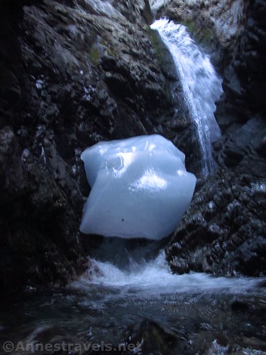
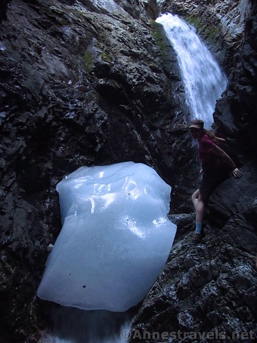
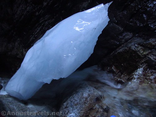
There is a small falls coming down into the canyon from the right; at this point (I don’t recall what it was like in April, and maybe I didn’t get close enough to see, or maybe I was behind three other people all standing on rocks in front of me, so I couldn’t see anyway) there was a huge chunk of ice over this small falls left over from the winter cold. It’s really neat to see, and very, very cold (did I mention freezing in April?)
One of my group pauses to pose while scrambling up to the pool above the lower tier of the falls
A few of us scrambled up the side of the small falls so we could see the larger falls cascading into a pool. It was very wet in there, but we didn’t get our feet wet because we could stand on the (very wet, very slippery) edges of the canyon just above the pool below the falls.
Looking up the upper tier of the falls while standing by the pool
There wasn’t much space, and our bravery seemed to be encouraging others to come up (yikes!), so we very carefully climbed back down to give others a chance at the upper falls.
The pool below the upper tier of the falls
Walking back down the canyon, the air grew warmer and warmer again. It was so cold back in the canyon that we had almost forgotten it was quite so warm in the real, outside world!
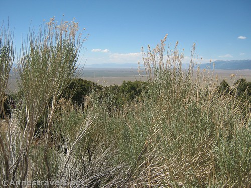
Bushes along the trail
Round Trip Trail Length: About 1 mile
Elevation Change: About 200ft. (My GPS clocked 184ft. between the trailhead and the river; you do go up a little more in the canyon, but my GPS doesn’t like tight spaces)
Facilities: Campground, picnic area, primitive restroom, and a very nice overlook over Great Sand Dunes in the parking area
Fees: None
Trail Notes: Use care on the rocks in the river – some are slippery, and others will turn or shift under your feet. Wear sturdy shoes (I couldn’t quite get over the number of hikers in flip-flops on the rugged trail). The campground is nice because it’s a lot higher than the surrounding area, so it’s a bit cooler than being down on the plain. Remember that the canyon is cold most times of the year and you might want to dress accordingly, especially if you plan on hiking up the river in cool weather.
Looking down on the ice block from above the lower tier of the falls (by the pool)
Trail 
![]()
![]()
Road ![]()
![]()
Signs ![]()
Scenery ![]()
Would I go 100 miles out of my way for this? ![]()
![]()
Overall Rating: 
![]()
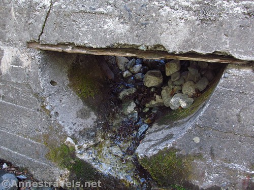
A dam once stretched across the canyon – very likely, a pipe came out of this opening
GPS Coordinates for Zapata Falls
Trailhead: 37.6216167°, -105.5594833° (N37° 37.297′ W105° 33.569′ / 37°37’17.8200″, -105°33’34.1400″) (9,043ft.) (0.0) (end 0.98)
Zapata Lake Junction: 37.6202500°, -105.5544500° (N37° 37.215′ W105° 33.267′ / 37°37’12.9000″, -105°33’16.0200″) (9,228ft.) (0.37)
River: 37.6199667°, -105.5541000° (N37° 37.198′ W105° 33.246′ / 37°37’11.8800″, -105°33’14.7600″) (9,227ft.) (0.40)
The gpx file for Zapata Falls can be downloaded – please note that this and the GPS Coordinates are for reference only and should not be used as a sole resource when hiking this trail.
Download GPX File size: 20.9 KB Downloaded 410 times
(Note: I do my best to ensure that all downloads, the webpage, etc. are virus-free and accurate; however, I cannot be held responsible for any damage that might result, including but not limited to loss of data, damages to hardware, harm to users, from use of files, information, etc. from this website. Thanks!)
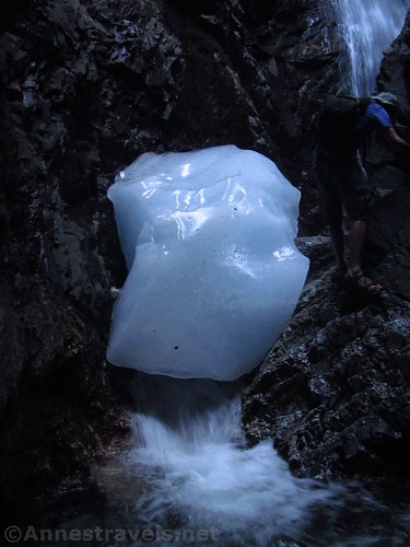
The ice block over the lower tier of Zapata Falls
Getting to Zapata Falls
From the Great Sand Dunes Visitor Center, drive south on the entrance road. After 8.7 miles, turn left on a dirt road, following the sign for “Point of Interest – Zapata Falls”. Take this rock-studded, extremely steep dirt road 3.5 miles to the trailhead.
From Taos, New Mexico, drive north on NM-522 which will become CO-159. After about 75 miles, turn left on US-160 W (you’ll be in the town of Fort Garland) toward Alamosa (the intersection might as well be a T; it’s hard to miss). Drive 10.3 miles, then turn right on CO-150 N following signs for Great Sand Dunes National Park and “Bureau of Land Mgt – Zapata Falls Recreation Area 10 Miles”. After another 10.3 miles, turn right on the rock-studded, extremely steep dirt road 3.5 miles to the trailhead.
From Alamosa – drive 14 miles east on US-160E; turn left on CO-150 toward Great Sand Dunes and follow the directions (above; from Taos) to Zapata Falls.
The turn onto CO-150 is about 70 miles west of Walsenburg (on I-25) via US-160 W.
I was very surprised at the (non) quality of this road, and also the many, many low-clearance vehicles at the trailhead. While there are plenty of rocks, it’s apparently not too dangerous, so it’s just the steepness that may trip you up. If you feel you can’t make it up the road, there is a parking area at the bottom. Trailers are not allowed on the road to Zapata Falls.
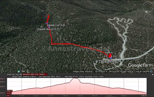
Visual trail map and elevation profile for the Zapata Falls Trail – unlike the elevation profile here, the trail does not go straight up at the end of the trail
Zoom map out to browse nearby hikes & places of interest
This Week’s Featured Product!
There is so much to explore, both in Great Sand Dunes and the surrounding area. This guide offers some of the best nearby hikes in the national park and in the nearby Sangre de Cristos mountains.


Pingback: Expectation, Reality, and Disappointment - Anne's Travels
Pingback: Sneak Peak: Southwestern Variety at its Finest - Anne's Travels