
I just got back from another hiking-adventure trip across the western US! It was different than any before, even as we visited old and new sites across Kansas, Colorado, New Mexico, Arizona, and even Utah and Wyoming. There were high points – the highest point in New Mexico and 12,000ft. Mt. Agassiz to views of the highest point in Utah – and old favorites like Pueblo Bonito in Chaco and trails into the Grand Canyon. In between were desert, Native American culture, the Grand Canyon, and so much more!

We started out in Monument Rocks, Kansas, a national park on private property with monoliths in the middle of the plains.

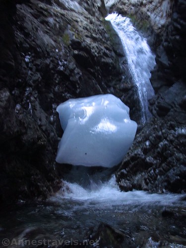
Later that day we pulled into Great Sand Dunes, and because no one wanted to spend the heat of the day on the dunes, we hiked to Zapata Falls. It was nice and cool in the falls’ canyon – there was even still some winter ice at the bottom of the falls!
Because of 25% of average snowpack last winter, the stream wasn’t flowing by the dunes as we had hoped. Still, we had a great time jumping the dunes, and a few of us even made it all the way to the top of Star Dune, the highest in the park!

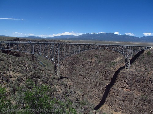
After jumping dunes until the sand started to burn our feet, we drove down toward Taos. There’s a bridge nearby over the Rio Grande that I’ve wanted to visit for about 12 years (literally). So we stopped and walked The Rio Grande Gorge Bridge, not to mention taking a few pictures along the way.
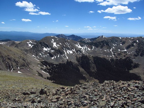
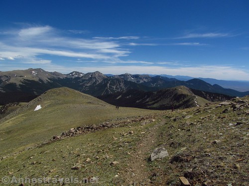
Our biggest destination in New Mexico was to climb Wheeler Peak, the highest point in the state. I was a little worried that it might still be snowed in, but due to the light snow year, we barely saw snow the whole way up. While we were on the trail anyway, we visited Williams Lake…
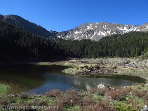

…Mt. Walker (the 2nd highest point in New Mexico)…
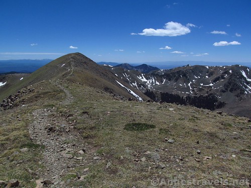
…And then climbed Wheeler Peak, proper.
Everyone was tired the next day, so in the afternoon we took a little stroll/bushwack up to Gavilan Falls.

Before climbing Wheeler, we had chatted with a couple men working for the Forest Service. They told us their favorite hike was Gold Hill, up via Bull-of-the-Woods Pasture, down via Long Canyon. I knew no more about it than that and looking at a map or two, but it looked nice, so we took off to climb the peak. It turned out to be one of our favorite hikes on the entire trip. Those guys definitely knew what they were talking about!
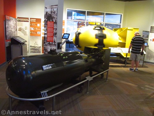
We moved on to Los Alamos. My plan had been to hike up to the Los Alamos Arch, but sitting in the parking area, a very nice woman in the neighborhood told us that all of the trails in the national forest were closed due to fire danger. She recommended a museum in town, so we spent a very enjoyable midday learning about the Manhattan Project at the Bradbury Science Museum.
In the evening (they wouldn’t let us drive in until 3pm) we hiked a couple old favorite trails in Bandelier National Monument – the Main Loop…

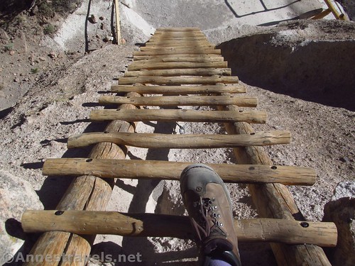
…and the trail to Alcove House (up all those fun ladders!)
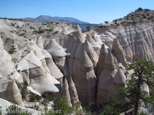
About 13 or 14 years ago, I ran across Kasha-Katuwe Tent Rocks National Monument. I’ve wanted to visit ever since, but it never quite works out. This time, despite all the national forests being closed, Tent Rocks was not, and it was worth waiting 13 years to see!
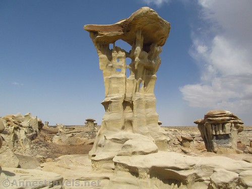
A little more recently – probably only about three or four years ago – I heard of an area of rock formations called the Valley of Dreams. It’s extremely remote, and very difficult to get to, but it’s amazing! First we visited the Valley of Dreams East…
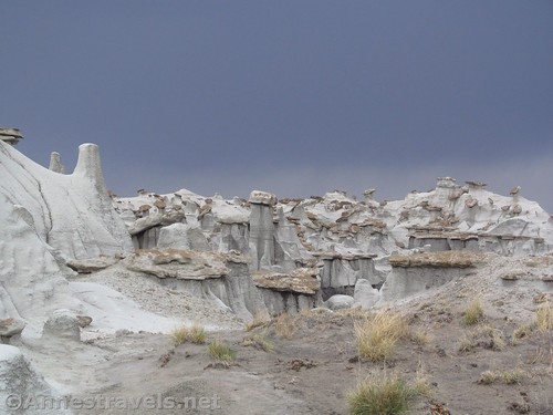
…then the Valley of Dreams, itself, as the sun finally came out!
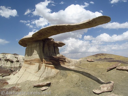
In the afternoon, we hiked over to the King of Wings. All of these would have been nearly impossible to find without the GPS – even if the GPS did get us in trouble by telling us to take roads that didn’t exist and others that went straight through people’s houses.
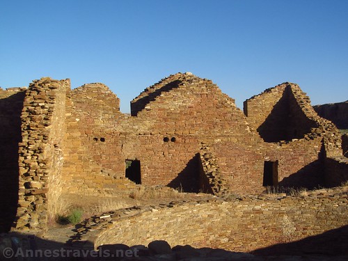
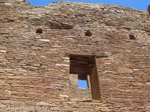
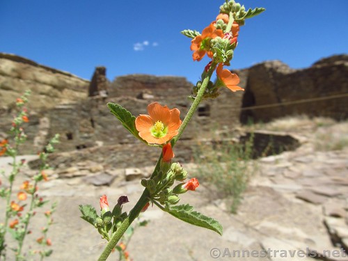
The next day we decided civilization would be nice (just kidding), so we went into Chaco Culture Historical Park. It’s always been our favorite Native American History park, and I was reminded just why. We did Pueblo del Arroyo…
…walked up to Kin Kletso…
…then took the Pueblo Alto Loop, which has been on our “to hike” list for probably close to 20+ years. (We’ve done the first portion a few times, but never the whole thing – I thought it quite nice.)
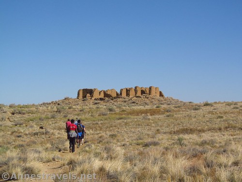
And a visit to Chaco wouldn’t be complete without visiting Pueblo Bonito.
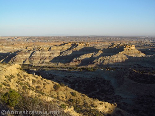
From there, we drove up to Angel Peak for the night. It was downright crowded; I think there were four other campers in the campground! Sunset was a disappointment, but sunrise was a bit better in terms of views.
One of my group members wanted to visit the Grand Canyon very much, so we ended up in the Toroweap area. I had read about the Whitmore Trail, and how it was only a 2 mile round trip trail to the river. That sounded great. But the road was rougher than we anticipated, and we ended up getting only about 4 miles from the parking area. We would have hiked the rest of the road, but it was a bit hot to be out hiking.

So we drove back up the road to the Mt. Trumbull Schoolhouse. The swings and seasaws were a real treat.

On a whim, following an official map I had picked up at the schoolhouse, we walked to the Nampaweap Petroglyph Site. It’s by far one of the best I’ve seen; there are images scratched into the rock everywhere!

We spent the night at the Tuweep Campground (high clearance required, 4×4 recommended, and prior reservations stipulated). Sunset was beautiful.
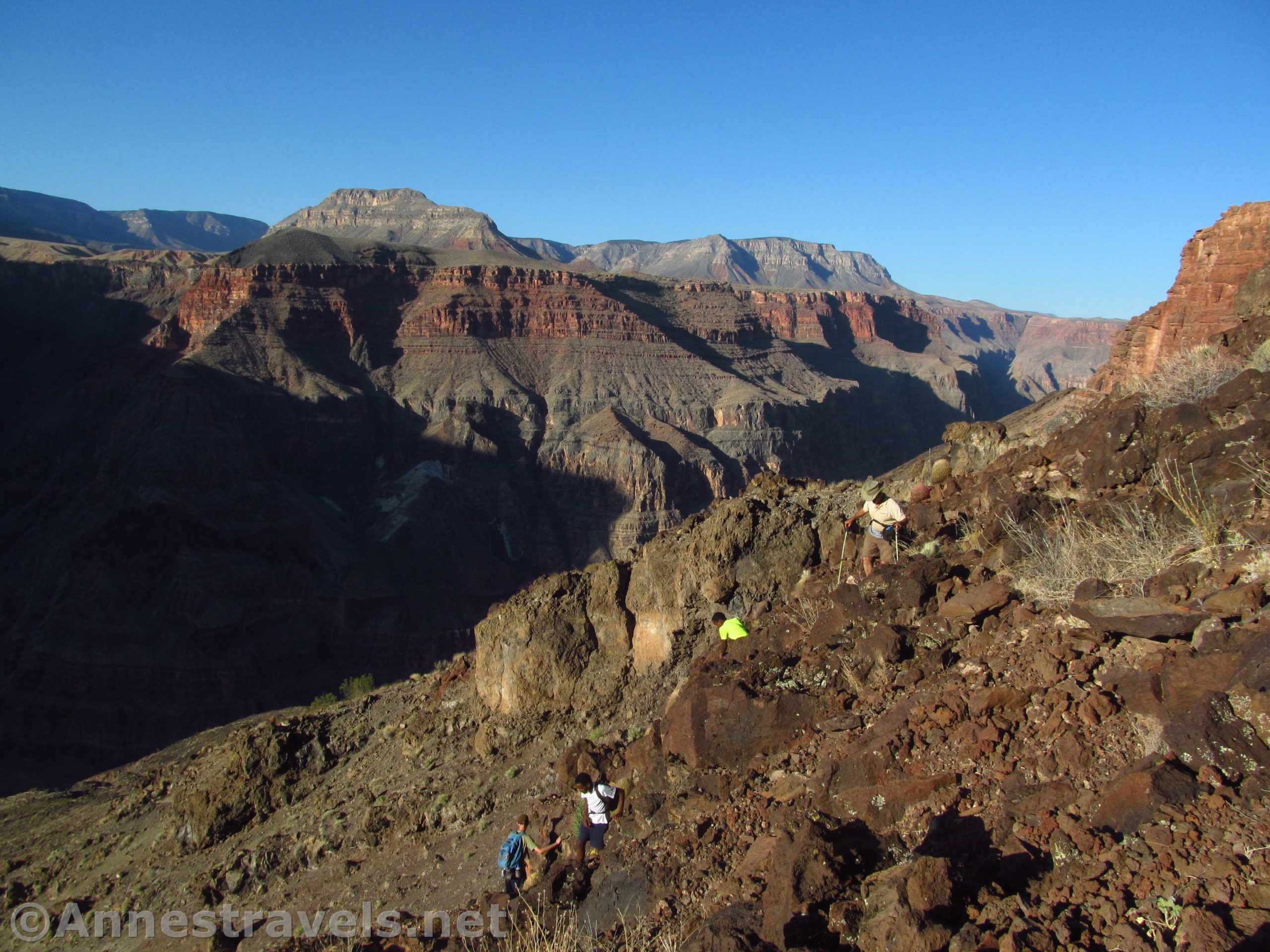
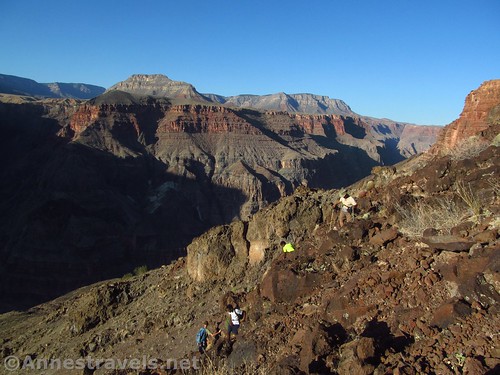
The next morning we got up very early to get on the Lava Falls Route to the bottom of the canyon before sunrise. We didn’t quite make it before sunrise, and we didn’t quite make it to the river, but we hiked most of the route before it got far, far too hot to be out hiking. The trail is a little less obvious than it was when I last hiked it 13 years ago!

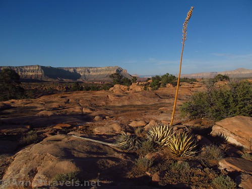
In need of gas and ice, we drove back into town, then down into the official North Rim of the Grand Canyon National Park. A short stroll along the Ken Patrick Trail revealed some great views.
And since we were there, we figured we might as well walk out to the Point Imperial Overlook.
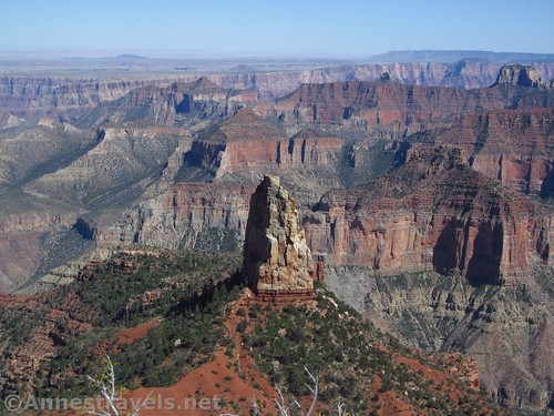
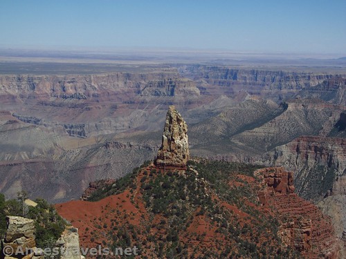
I had read on the internet (on a site we’ve been using for trail ideas since about 2001) about a few points along the North Rim that have great views of the canyon, but that don’t have official trails to them – it’s GPS navigation and bushwacking. We started with the one that looked the most interesting, Honan Point. All I can is that I never knew the North Rim had views like this; it’s absolutely stunning!

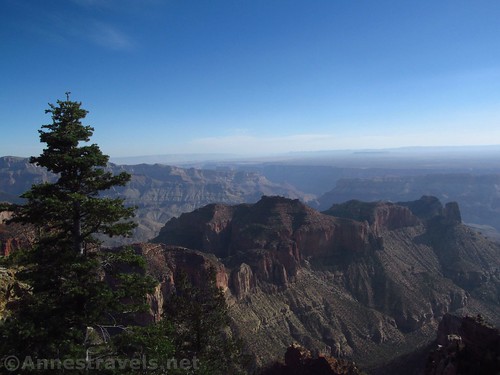
And since we were there, it only made sense to hike out to Cape Royal.

The next day, we did one last hike – another bushwack (this was really whacking bushes!) to Point Atoko. The view wasn’t as good as Honan Point, but it would have been quite nice if it hadn’t been quite so hazy. Oh, well.
A few weeks before we left, I ran across the Uinta Mountains in Utah, three times in one week in three completely, totally unrelated places. That was so odd – I’ve never heard of these mountains before, or since – so I got some trail info before we left, even though we weren’t planning to go to Utah. After Grand Canyon, feeling the heat in the southwest, we figured we would drive up to the Uintas and get out of the heat. We got close, stopped for internet, and discovered that the most recent information (about 2 weeks old) said all the trails I wanted to do were closed due to snow. Without much else we could do, and all the nearby ranger stations closed for employee training, we drove up into the mountains anyway.

The trail up Bald Mountain certainly had a little snow, but it was easily negotiated. And the views. Oh, wow!
The trail to Ibantik Lake was mostly dry, but what little wasn’t was reminiscent of last summer in the High Sierras – “Home, home on the trail! Where the streams and cataracts play! Where seldom is found a piece of dry ground. And the snowmelt increases each day! Everybody now…” The lake itself was lovely, and the views along the trail were stunning.

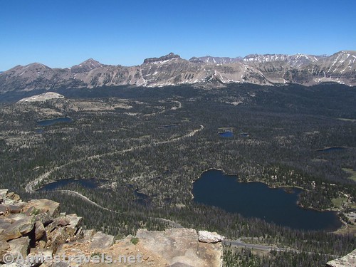
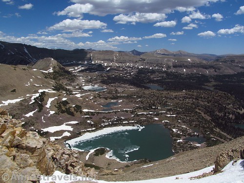
Our final hike was a real challenge: up the trailless Mt. Agassiz overlooking Naturalist Basin, not to mention Kings Peak (highest peak in Utah) and more peaks and lakes than I could count. Oh, wow-wow-wow! This one got on my favorites list for the sheer beauty of the views!
We did stop at Hobo Pool on the way home (we joked we came to the Uintas so we could go home I-80, past Hobo Pool, but really, it was icing on the cake). We also got smoked out by forest fires at the Lincoln Rest Stop as we tried to make and eat dinner dodging the sudden outbursts of raindrops.
But overall, it was a great trip, with so much variety it’s hard to pin down exactly what the trip was about – Deserts? Mountains? History? I think it’s all of the above, and so much more.

I’m looking forward to sharing all these places with you in the upcoming months! Stay tuned!
Browse more hikes here!
Zoom map in to browse individual hikes
This Week’s Featured Product!
I always try to take water purification tablets with me on hikes – I didn’t need them on this trip, but I came close a couple times and was thankful I had them.
More Related Posts:
 Beautiful, Beautiful Bonneville Pass
 Truckhaven Rocks: Views, Scrambles, and Geology!
 Day-hiking Coyote Gulch: Waterfalls, Arches, and Solitude
 Sneak Peak: A California Trip through Desert and Snow
 10 Hikes in New Mexico Kids Love! (And Adults Love, too!)
 Finding Butch Cassidy’s Cabin at Robber’s Roost
One response to “Sneak Peak: Southwestern Variety at its Finest”
[…] past trip, He led us, but it was much more hands-off. One of my group members wanted to visit the Grand […]