

Looking for a fun ramble on the North Rim of the Grand Canyon that actually has some views? Try the Ken Patrick Trail that begins from Point Imperial. The trail is actually a 10 mile shuttle hike between Point Imperial and the North Kaibab Trailhead, but since the 6.75 miles to the west (North Kaibab Trailhead to the road crossing) are forested, it only made sense to me to hike part of the trail that had a view: The 3.25 miles beginning at Point Imperial.
Quick Stats

Actually, I only hiked 2/3 of a mile along the trail, mostly due to the fact that my group was still exhausted from hiking the Lava Falls Trail the previous day, and we wanted to get into camp early to get a good night’s sleep before taking the route to Honan Point the next day. But the views were great, and given different circumstances, this would be a terrific hike with some good views!

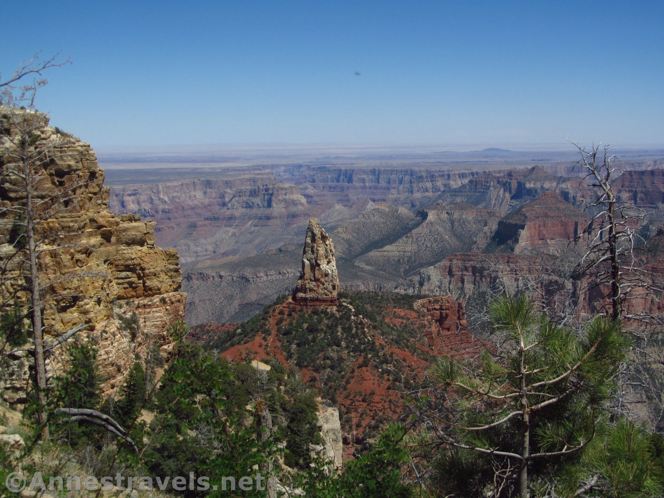
The Ken Patrick Trail begins near the far right end of the parking area (when you’re looking at the canyon) and heads west along the rim. Early views are a bit peek-a-boo through the trees and the nearby rock outcrops, but the further you walk, the better and less obstructed the views become (within reason – there is a lot of variation in view clarity along this trail!) The trail is quite winding, and sometimes it feels like you might be walking away from the canyon as much as seeing views across the canyon!

Be aware that the trail is not flat. In fact, it undulates quite a bit, uphill, downhill, following the contour of the rim. This area has seen a wildfire, and the brush has come back but the trees haven’t (yet). In general, it’s not a bushwack as long as enough people have used the trail to keep the brush back.

After about 0.66 miles, we decided we’d had enough of hiking for the day. There is a very nice viewpoint at this point, and we could see that the trail dipped way down before rising again, so we weren’t going to get another good view for a bit and it was going to be a lot of effort.
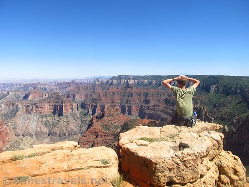
So we stopped on the stone outcrop with a big, flat rock on it and took in the view. It’s pretty obvious that a lot of people do this, and by the time we left, a young couple was sitting on the rock, arms around each other, taking in the view.

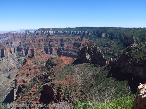
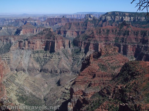
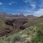
The view itself is dominated by Point Imperial to the left (probably better views of Point Imperial than from the official Point Imperial Viewpoint – different, at the very least), and you can see over to the south rim of the canyon. There are also excellent views down into the side canyon below you.
The trail wasn’t crowded on a Thursday afternoon in June. We saw maybe four or five other groups of maybe 1.5 dozen people total.

To keep going all the way to the road crossing, just keep following the Ken Patrick Trail. It passes through more brush and light forest, often right along the rim, although it twists back toward the road at times because of the contour of the land. There are more good views down into the side canyon and to Point Imperial before reaching the road about mile 3.25.

Round Trip Trail Length: I did 1.3 miles to the unofficial viewpoint; 6.5 miles along the rim to the road crossing (and back); 9.9 mile shuttle from Point Imperial to the North Kaibab Trailhead
Vertical Change: 109ft. (8,699ft. to 8,808ft.) for the first 0.6 miles to the unofficial viewpoint; 338ft. (8,470ft. to 8,808ft.) for the full 3.25 miles to the road; 694ft. (8,114ft. to 8,808ft.) for the 9.9 mile shuttle
Facilities: Primitive restrooms at the trailhead
Fees: $35/vehicle, valid 7 days. National Park & Federal Recreational Lands Passes and Grand Canyon Annual Pass are accepted.
Trail Notes: This is a nice little adventure. Use care at the unofficial viewpoint as there are no guardrails. Be sure to bring water; it’s not a long path, but it’s very dry. You can easily also walk out to the Point Imperial Viewpoint.
Trail 
![]()
![]()
![]()
Road
Signs ![]()
![]()
Scenery ![]()
Would I go 100 miles out of my way for this? ![]()
Overall Rating: 
![]()

GPS Coordinates for the Ken Patrick Trail (East End)
Trailhead: 36.2784833°, -111.9789000° (N36° 16.709′ W111° 58.734′ / 36°16’42.5400″, -111°58’44.0400″) (8,808ft.) (0.0) (end 1.46)
Great Viewpoint: 36.2761500°, -111.9878833° (N36° 16.569′ W111° 59.273′ / 36°16’34.1400″, -111°59’16.3800″) (8,699ft.) (0.66)
The gpx file for my walk along the east end of the Ken Patrick Trail can be downloaded – please note that this and the GPS Coordinates are for reference only and should not be used as a sole resource when hiking this trail.
Download GPX File size: 33.9 KB Downloaded 422 times
(Note: I do my best to ensure that all downloads, the webpage, etc. are virus-free and accurate; however, I cannot be held responsible for any damage that might result, including but not limited to loss of data, damages to hardware, harm to users, from use of files, information, etc. from this website. Thanks!)
Getting to the Ken Patrick Trailhead (Point Imperial)
From the North Rim Entrance Station, continue south for 9.6 miles. Turn left on the road marked for Point Imperial and Cape Royal. After 5.4 miles, turn left toward Point Imperial (not right toward Cape Royal). Drive 2.7 miles to the end of the road at the Point Imperial Viewpoint.
From the North Rim Visitor Center, drive north 3 miles. Turn right on the road marked for Point Imperial and Cape Royal. After 5.4 miles, turn left toward Point Imperial (not right toward Cape Royal). Drive 2.7 miles to the end of the road at the Point Imperial Viewpoint.

Zoom map out to browse nearby hikes & places of interest
This Week’s Featured Product!
For more interesting and scenic trails in Grand Canyon National Park – both north and south rims – check out this book with trails both in the main part of the park and also along the dirt roads to the west.


2 responses to “Hiking the Ken Patrick Trail (East) & Enjoying the Views!”
[…] then down into the official North Rim of the Grand Canyon National Park. A short stroll along the Ken Patrick Trail revealed some great […]
[…] Hiking the Ken Patrick Trail (East) & Enjoying the Views! […]