I’ve always thought the views from the South Rim of the Grand Canyon to be better than the views from the North Rim. Part of it is that the North Rim is more picturesque, so looking at it from the South Rim is more impressive. Part of it also is that the North Rim is further east than the South Rim (mostly; the North Rim is pretty much across from Desert View), so it doesn’t even go to the best of the views you’d see from behind the visitor center on the South Rim. But on my last trip to the North Rim, I found one solitary viewpoint that rivals the South Rim in beauty: Honan Point, well off the beaten path, but still only a 5.25 mile RT hike. And the second best part is that you get to see a number of the South Rim features (Grandview Fire Lookout and South Kaibab Trail, among other sites).
Quick Stats
Note: Some of the links in this post are affiliate links. If you click one and purchase something, I may earn a small commission without an extra cost to you.
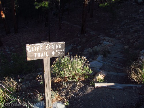
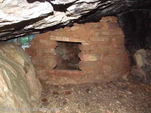
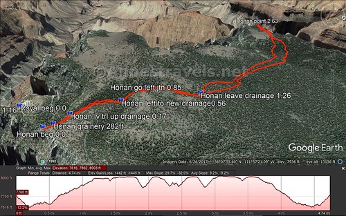
The trail – or route, really; it pretty quickly leaves the trail – begins at the parking area for Cliff Springs, 0.5 miles before the end of the road at Cape Royal. Walk down the trail, passing by the Native American granary.
At the bottom of the side drainage the trail has been following, the trail takes a sharp left to travel along the edge of a larger drainage (this is 0.1 miles from the parking lot). Instead of turning left with the trail, scramble down (more or less straight) into the drainage and turn right up this larger drainage. It’s pretty obvious when you’re there, but takes some words to describe.
Walk up this drainage (no trail from here on out) for 0.4 miles. At this point, a side-drainage enters from the left; it’s not obvious but is marked by a 6 or 8ft. dryfall. Scramble up (or around) the dryfall and walk up this sidedrainage for 0.3 miles.
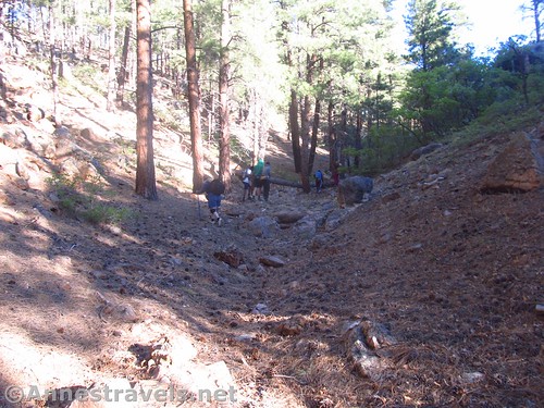
Here the drainage splits (it’s pretty obvious). Take the left fork and continue to walk up the drainage. There are generally social trails around the small snags in the bottom of the drainage, or there is a vague social trail almost along the rim of the drainage in places. You just want to keep following the drainage upward.

At 1.25 miles from the parking area (0.4 miles from the last drainage split), the drainage will begin to climb more steeply, so it will approach the same height as the surrounding land. Here you want to turn left to scramble out of the drainage. If you go too far, the drainage simply becomes pretty much the same height as the surrounding forestland, and you can just turn left at that point. Walk in a generally straight line through the pines so that your back is to the drainage you just exited.
Shortly after leaving the drainage, you may or may not notice that you cross an old logging road. I knew it was there, otherwise, I might have missed it. The great thing is that a forest fire burned through here a few years ago, so there’s pretty much nothing in terms of underbrush. There is some windfall, and do watch for dead trees, but in general, it’s an easy hike.
Keep walking as you cross two more drainages – the first is an obstacle that is fairly easily crossed; the second is steeper, so you might want to walk left or right along the rim and/or the bottom of the drainage to find a slightly less steep way down or up.
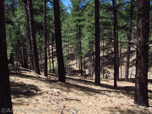
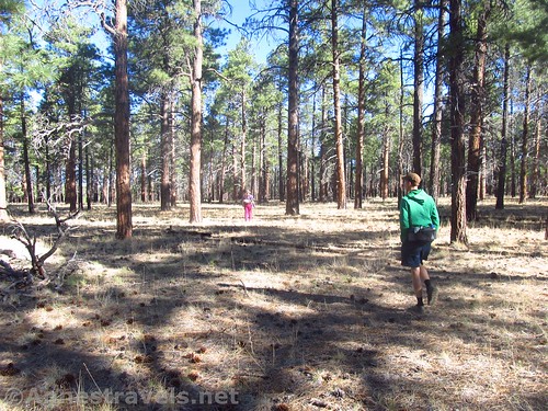
After crossing the second drainage, the forest opens up to more open meadows. Follow your own route or one of many social trails across the meadow heading straight ahead for the canyon rim.

From here, it’s really hard to tell you exactly where to go if you aren’t using a GPS. I was navigating using coordinates I picked up off GoogleMaps before I left, but I didn’t use them for anything but making sure we were generally heading in the right direction until we came to the canyon rim. At that point there are quite a number of social trails. We ended up hitting the canyon too far to the right, so we walked left along the rim (really, just inside the scrubby trees) for a few minutes before coming to the landbridge that led us out onto Honan Point.
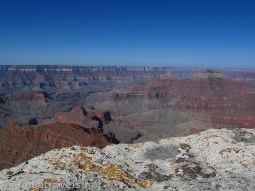
It’s a bit of a tangle on the landbridge (a few too many juniper trees to not have to stoop), but once you’re out on the point, it’s just a slab of rock, and the views are unobstructed.
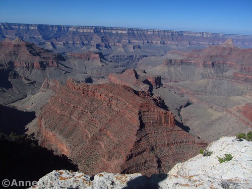
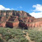
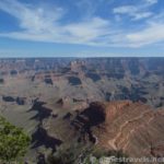
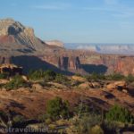
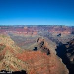
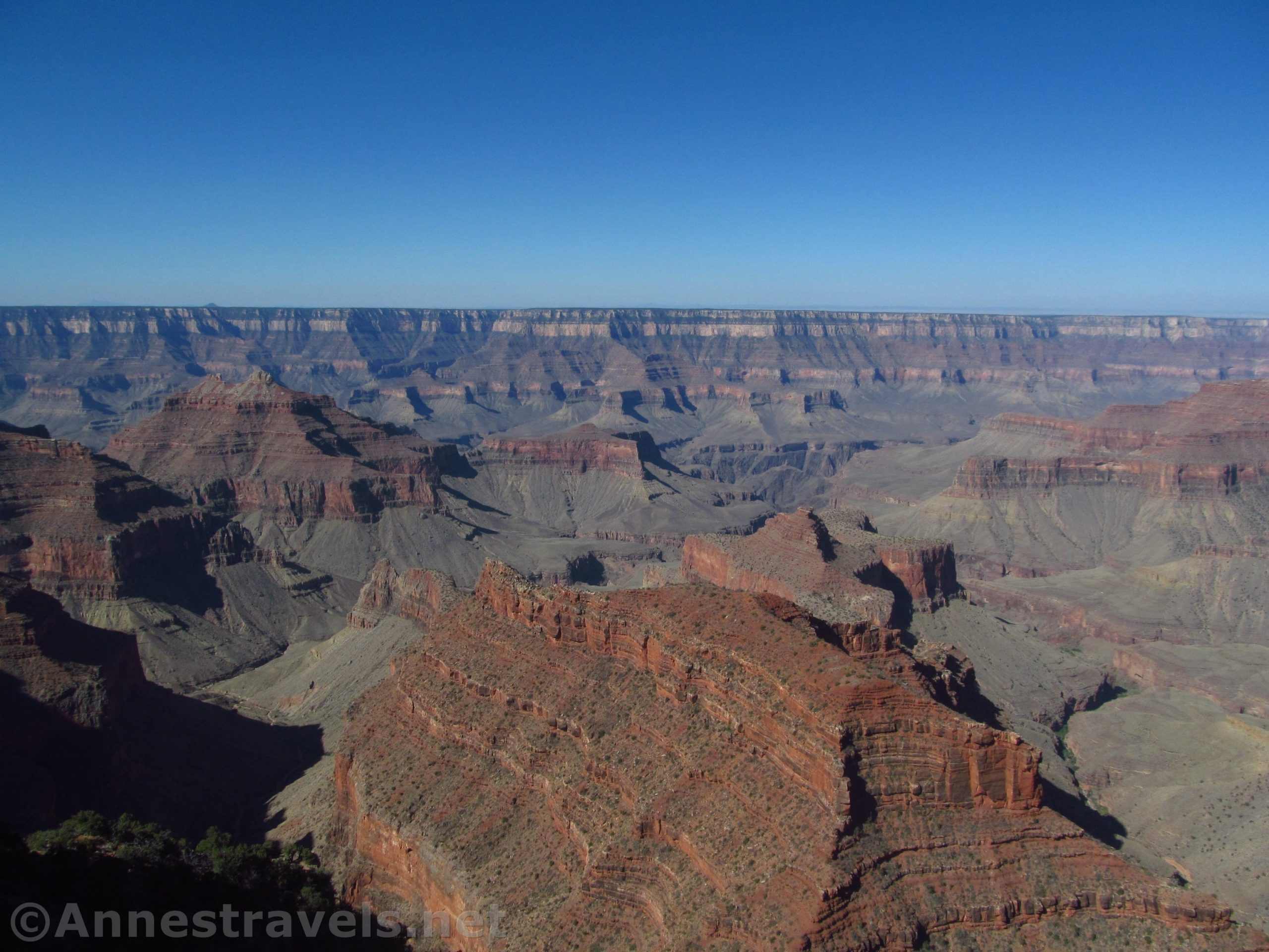
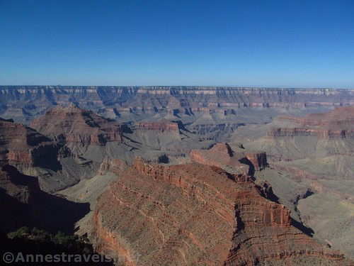
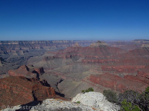
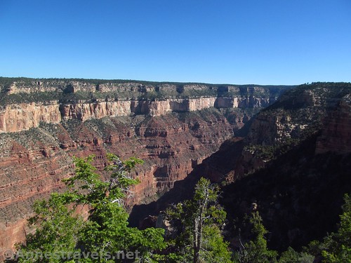
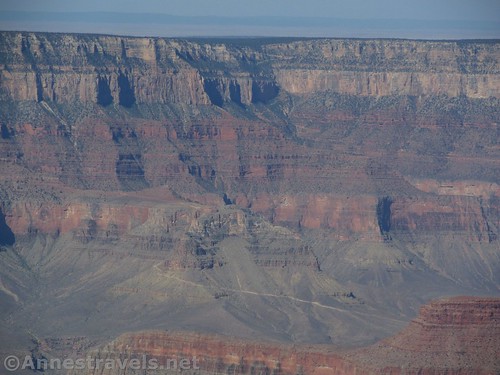
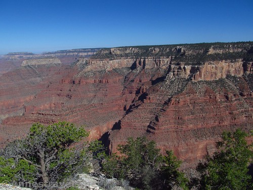
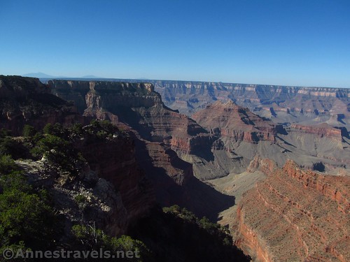
And oh, the views! They’re by far the best I’ve ever seen on the North Rim (or at least, by far the views most like the South Rim). So many “temples”, cliffs, buttes, drainages; all in Grand Canyon red and white and yellow. It’s simply gorgeous!
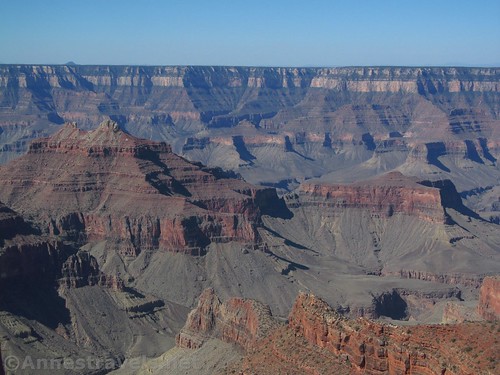
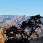
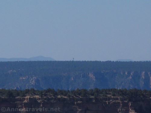
Out across the way is an obvious white trail; This is the South Kaibab Trail on either side of the “Great Whites”. Just to the right of the trail are the upper switchbacks (white) of the Bright Angel Trail. You can also see the Grandview Lookout Tower a bit to the left along the rim (it stands out against the sky on a clear day, and it was quite clear the day I visited). With a little foreknowledge and/or a map, you can also figure out where the Bright Angel Trail goes down.
We hung around for a bit before returning (just slightly different route – no trail means that you just might take different route back). It wasn’t hard to find the correct ravine (stay more right than left) to go back down, and from there it was just a matter of retracing our steps.
Overall, I’m glad I didn’t try to find Honan Point without a GPS, but if you’re good with topo maps, that would probably work, too. Next time, I’d like to come in from a different angle and try for the next outcrop over – Francois Matthes Point!
Round Trip Trail Length: About 5.25 miles
Net Elevation Change: 387ft. (7,616ft. to 8,003ft.) (but you’re going up and down a few times, so total gain is closer to 1,440ft.)
Facilities: None – but do check out the views of Angel’s Window and the Grand Canyon from at and near the parking area. There are restrooms at the Cape Royal Parking Area.
Fees: $35/vehicle, valid 7 days. Federal Lands Passes and Grand Canyon Annual Passes also accepted.
Trail Notes: The majority of this hike is off-trail – be prepared and know what you’re doing before you hike. If you get hopelessly lost, walk east and you’ll hit the park road eventually. I expect the undergrowth-free conditions to continue for a few years, but eventually this may be a harder hike than it is now – a pleasant stroll through the forest. Use care at the viewpoint as there aren’t any railings. You can also walk to Cliff Springs, about 0.4 miles beyond where you leave the trail.
Trail 
![]()
![]()
![]()
Road ![]()
Signs ![]()
![]()
![]()
Scenery
Would I go 100 miles out of my way for this?
Overall Rating: 
![]()
Key GPS Coordinates for Honan Point
Cliff Springs Trailhead: 36.1246333°, -111.9479500° (36°07.47800′, -111°56.87700′ / 36°07’28.6800″, -111°56’52.6200″ / N36° 07.478′ W111° 56.877′) (7,738ft.) (0.0) (end 5.22)
Granary: 36.1251000°, -111.9485833° (36°07.50600′, -111°56.91500′ / 36°07’30.3600″, -111°56’54.9000″ / N36° 07.506′ W111° 56.915′) (7,698ft.) (282ft.)
Leave Trail; turn right up the drainage: 36.1255167°, -111.9503167° (36°07.53100′, -111°57.01900′ / 36°07’31.8600″, -111°57’01.1400″ / N36° 07.531′ W111° 57.019′) (7,617ft.) (0.17)
Drainage Junction – Go Left: 36.1286500°, -111.9528667° (36°07.71900′, -111°57.17200′ / 36°07’43.1400″, -111°57’10.3200″ / N36° 07.719′ W111° 57.172′) (7,640ft.) (0.56)
Drainage Junction – Go Left: 36.1302500°, -111.9547500° (36°07.81500′, -111°57.28500′ / 36°07’48.9000″, -111°57’17.1000″ / N36° 07.815′ W111° 57.285′) (7,763ft.) (0.85)
Leave Drainage: 36.1344333°, -111.9544833° (36°08.06600′, -111°57.26900′ / 36°08’03.9600″, -111°57’16.1400″ / N36° 08.066′ W111° 57.269′) (7,933ft.) (1.26)
Honan Point: 36.1384833°, -111.9710000° (36°08.30900′, -111°58.26000′ / 36°08’18.5400″, -111°58’15.6000″ / N36° 08.309′ W111° 58.260′) (7,894ft.) (2.63)

The gpx file for Honan Point can be downloaded – please note that this and the GPS Coordinates are for reference only and should not be used as a sole resource when hiking this trail.
File size: 101.1 KB Downloaded 0 times
(Note: I do my best to ensure that all downloads, the webpage, etc. are virus-free and accurate; however, I cannot be held responsible for any damage that might result, including but not limited to loss of data, damages to hardware, harm to users, from use of files, information, etc. from this website. Thanks!)
Getting to Honan Point Parking Area
Use Coordinates 36.1246333°, -111.9479500° and park in the pullout across the road.
From the North Rim Visitor Center, drive north (back toward the park entrance). After 3 miles, turn right, following sings for Point Imperial and Cape Royal. After 5.4 miles, turn right again, again following signs for Cape Royal. Drive 13.7 miles and then turn left into a pullout. A sign on the right side of the road marks the Cliff Springs Trailhead.
From the North Rim Entrance Station, continue driving south. After 9.6 miles, turn left, following the sign for Point Imperial and Cape Royal. After 5.4 miles, turn right again, again following signs for Cape Royal. Drive 13.7 miles and then turn left into a pullout. A sign on the right side of the road marks the Cliff Springs Trailhead.
Zoom map out to browse nearby hikes & places of interest
This Week’s Featured Product!
Looking for more trails on the north rim or south rim of the Grand Canyon? Try this guide that offers hiking suggestions on both rims.