

The Tuweep area of Grand Canyon National Park isn’t as overlooked as it once was – but even so, it seems to be settling back into oblivion. The Toroweap Overlook is still a favorite for photographers, and the Lava Falls Trail still draws adventure-seekers, with people staying at the Tuweep Campground so they can experience sunrise or sunset over the Grand Canyon. But unlike 10 or so years ago, the area has fallen off of the “new place you’ve never heard of” lists. And since you need technical 4×4 to reach most of the overlooks and trailheads in the area, it’s beginning to be relegated to the adventurous with special equipment.
Quick Stats
(Affiliate links are present on this page.)
But if you do end up in the area, you’ll want to see sunset from Toroweap Overlook. Or sunrise. Or you’ll want a very early-morning start on any of the trails in the area. The gate at the ranger station is technically locked from about 30 minutes past sundown to sunrise, so the only way to do justice to the Tuweep area is to stay at the Tuweep Campground (currently $10 per permit + $8 per night; it was free back in 2005).
You can get to the ranger station and even to the turnoff for the Lava Falls Trail in a low-clearance vehicle (high clearance is better but usually not required in dry weather). To get to the Tuweep Campground and beyond to the Toroweap Overlook you’ll need 4×4 – and be ready for some technical climbs at that.
I did get to both the campground and the Toroweap Overlook in my high clearance van. Actually, I got to both in two different high clearance vans – a 1998 Dodge Ram 1500 van in 2005 and a 2010 Ford E150 in 2018. The road was much worse in 2018; we had to rebuild it to get up the slickrock to the campground. Don’t be like me; come prepared with 4×4 and high clearance!

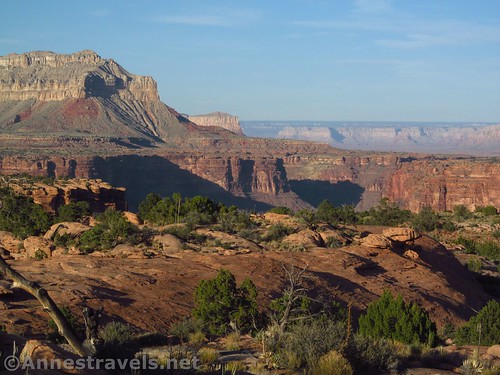
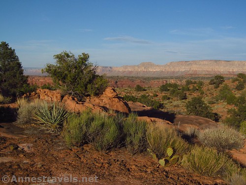
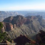
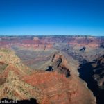
Still, if you get to the campground, I highly recommend that you go wandering across the slickrock beyond the campground around sunset. The views are absolutely fabulous; slickrock, desert plants, buttes and cliffs, and the Grand Canyon nearby.
You probably could walk all the way over to the rim – I did not (in part because I was alone and I was trying not to stray too far with no cell service just before dark). But as the golden glow of evening spread over the landscape, I was out on the slickrock with my camera to try and capture the end of the day.

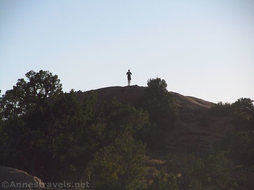
Some of my group was exploring closer to the campground. There are rocks you can scramble up for a higher view over the surrounding area.
The campground itself is primitive – picnic tables are provided in the 10 sites (no fire pits since fires aren’t allowed) and there are composting toilets. No water is available, and all trash must be packed out. The permit to camp must be purchased in advance – no permits are handed out at the ranger station. There were four or five other groups in April on my first visit; there were one or possibly two other groups in the campground on our most recent visit in early June (I wouldn’t want to be there in June either – it’s way too hot!)
But if you end up at the Tuweep Campground, be sure to put on some good shoes, stay on the slickrock to protect the fragile soil, and enjoy sunset by the Grand Canyon!
Round Trip Hiking Length: Varies. Realize that there are no trails and you’ll be scrambling across slickrock. It’s not technical by any means unless you’ve never done it before.
Campground Facilities: Picnic tables, primitive toilets (no water)
Campground Fees: $10 per permit with an additional fee of $8 per group per night. Advance permits are required. It does not appear that the normal Grand Canyon National Park fee is levied for the Tuweep area.
Hiking notes: There are a few trails in the Tuweep Area, but for the most part on this trek you’re on your own. Be sure to have on good footwear and take a map/compass so you can find your way back. (Speaking of which, be sure to get back to the campground before dark!) Stay on slickrock rather than the fragile soil and do not disturb desert plants.
Road 
![]()
![]()
![]()
![]()
Signs ![]()
![]()
![]()
Scenery ![]()
Ease of access / walking ![]()
![]()
![]()
Price for value ![]()
Would I go 100 miles out of my way for this? ![]()
Overall Rating: ![]()
![]()

GPS Coordinates for the Tuweep Campground
Tuweep Campground: 36.223634, -113.060286 (36°13.41804′, -113°03.61716′ / 36°13’25.0824″, -113°03’37.0296″)
Toroweap Overlook Parking Area: 36.214749, -113.056955 (36°12.88494′, -113°03.41730′ / 36°12’53.0964″, -113°03’25.0380″)

Getting to the Tuweep Campground
From St. George, drive south on I-15. Take Exit 2 toward UT-7; stay in the left lane on the exit to stay left to cross the bridge and then continue straight on UT-7 West. After 3.1 miles, take the exit (on right) toward River Road. Turn right at the end of the exit ramp to immediately cross the state line into Arizona. The road becomes dirt. Drive south about 38.5 miles, staying right when a road to a radio tower diverges left after about 14.3 miles. Stay right for another 8.1 miles and stay right again for another 3.1 miles to the Mt. Trumbull Schoolhouse. Turn left toward Toroweap or Tuweep (various signs say different things) and Mount Trumbull. Continue on this road 19 miles as it winds up and across the mountains, then back down into the next valley (stop along the way and see the Nampaweap rock art, if you want). Turn right to drive south on Hwy 115 for 7.6 miles to the ranger station; continue straight another 3.4 miles to the spur road that leads to the Lava Falls Trailhead on the right. Continue straight another 1.9 miles (the road gets much rougher after the spur road) to the turnoff for the Tuweep Campground on the left. Turn left; after about 0.1 miles, turn right on a spur road that will take you down to the campground.

From a more easterly direction – and for a route that is passable by passenger cars – take the road to Toroweap southward (the road is along AZ-389 and is 5.1 miles east of the road to Pipe Springs National Monument and 8.3 miles west from the US-89A / AZ-389 junction in Fredonia). Drive south toward Toroweap about 27 miles (take it slow, about 30mph or less, to avoid flat tires – they say about 25% of visitors have a flat on the road). A “major” road will turn right here with signs for Mount Trumbull, etc. Continue south (straight) toward Toroweap another 7.6 miles to the ranger station; continue straight another 3.4 miles to the spur road that leads to the Lava Falls Trailhead on the right. Continue straight another 1.9 miles (the road gets much rougher after the spur road) to the turnoff for the Tuweep Campground on the left. Turn left; after about 0.1 miles, turn right on a spur road that will take you down to the campground.

For the “easterly direction” driving directions, the driving up to the turnoff for the spur to the Lava Falls Trailhead is challenging but not horrible – chances are you’ll be able to drive the road in a hearty (if not exactly rugged) vehicle. High clearance is much better, but not necessarily required (I’ve heard of several people who drove it in vehicles similar to a Camry, and at least one guy did it in a PT cruiser – but he’s the exception not the rule). After the turnoff, the road requires 4×4 and includes loose rocks and small steps.

This Week’s Featured Product!
Either you love this book or you hate it – but if you’re looking for a guide to remote places to photograph the Grand Canyon, you just might be one of the lovers. You’ll want to be an explorer, though, since it seems more time is spent on the less-visited spots than ones along the road.

One response to “Sunset at the Tuweep Campground”
[…] spent the night at the Tuweep Campground (high clearance required, 4×4 recommended, and prior reservations stipulated). Sunset […]