

If you’re looking for one of the most prolific and best-preserved rock art sites I’ve ever seen in the southwestern US, look no further than the Nampaweap Rock Art Site in the Mt. Trumbull Wilderness (part of Grand Canyon-Parashant National Monument). You have to brave some pretty rough dirt roads (high clearance required; 4×4, not as much if you’re careful), and walk a sandy trail 1.5 trail (RT), but the sheer number and variety of petroglyphs on the volcanic canyon wall make it well worth the trouble.
Quick Stats
(Affiliate links are present on this page.)
We visited Nampaweap on a whim; after failing to finish the drive on the Whitmore Trail, we picked up an official map of Grand Canyon-Parashant National Monument at the Whitmore Schoolhouse (the first was not the reason for the second, btw). Studying the map while we drove back through the Mt. Trumbull Wilderness toward the Toroweap area, I discovered it wouldn’t be that far out of the way to hike to the petroglyphs. I was definitely in the mood to take a hike that actually worked, and it looked as though this would work.
The road to the trailhead was well-marked with a sign for Nampaweap (we had seen the sign on the way into the Mt. Trumbull Wilderness the day before, so we knew it was there) and the road, while rougher than the main road, was still passable in the very dry weather by our high-clearance, no-4×4 van.
We parked in a little shade offered by a few pines at the far end of the make-shift parking area (I’d say not too many people visit, and many who do are 4x4ing on the road that extends beyond the parking area – after the trailhead, the road deteriorates quickly). The trailhead is by the gate. A sign talks about the Nampaweap rock art and the trail ahead.

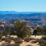
Basically, you just want to follow the dusty old road downhill between the pines. You can’t get lost here. It was very hot on a summer’s afternoon in June, but the elevation made it much more bearable than down at the schoolhouse or Toroweap – I’d say it wasn’t much more than 80F.
After an easy 0.5 miles, a very unobtrusive, unmarked trail goes off left. You’ll know it’s the right one because there are wooden-and-dirt stairs leading down into the ravine, along with (I believe) a trail register. We certainly weren’t the first people on the trail, nor were the visitors only American. I have to hand it to the Germans, especially; they seem able to find the most remote places in the American wilderness!
Descend into the wash; at the bottom, social trails go left and right. Turn left to the best of the rock art.
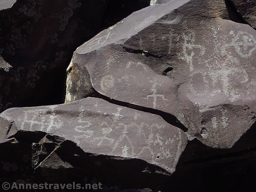
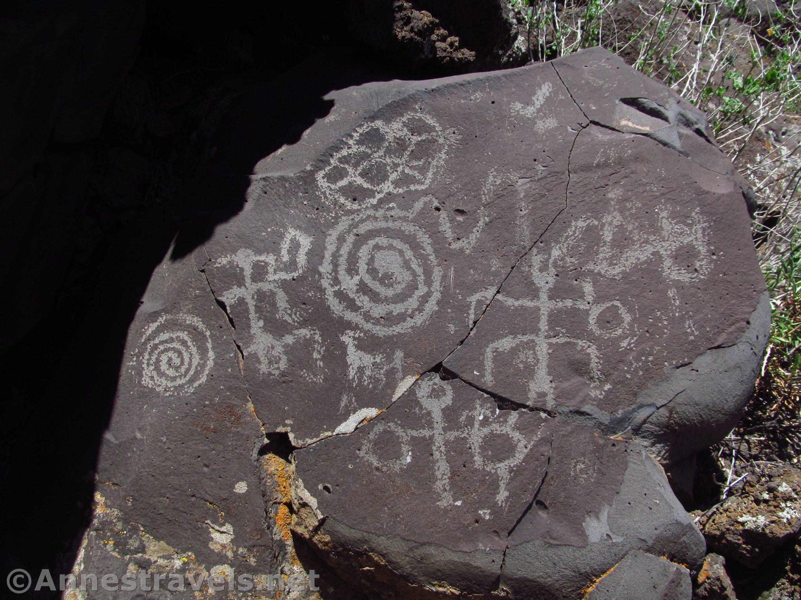
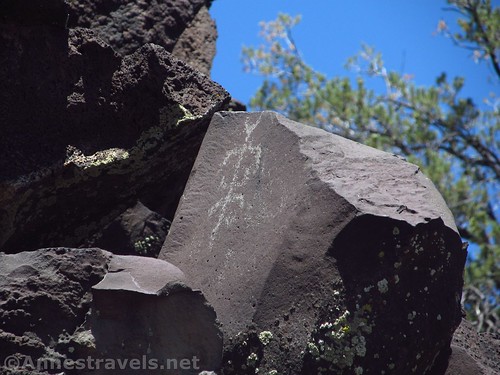
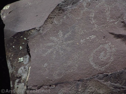
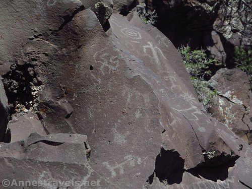
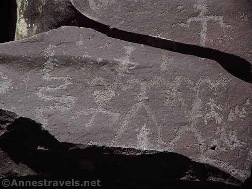
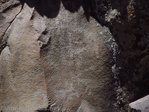
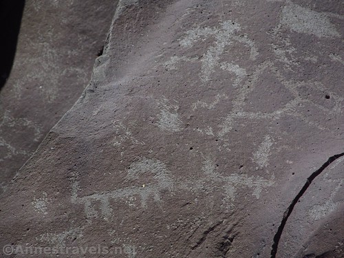
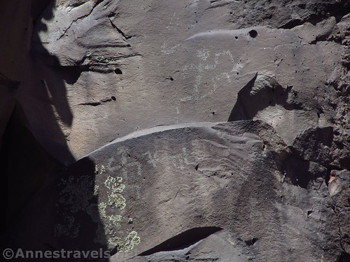
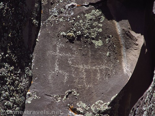
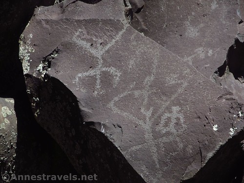
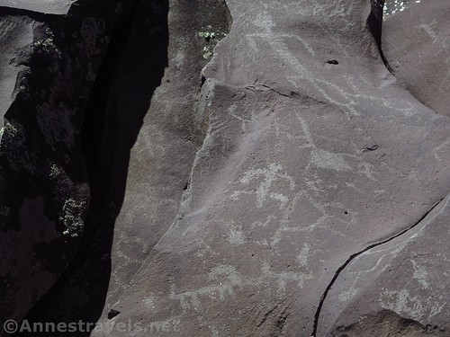
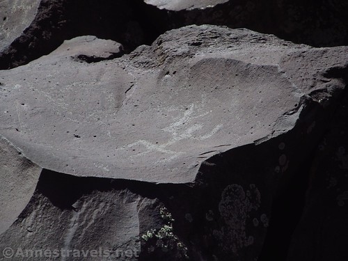
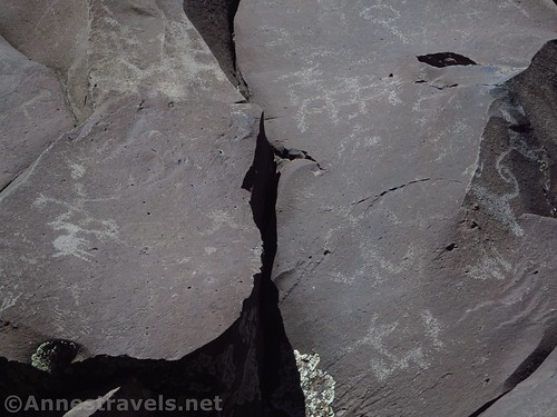
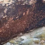
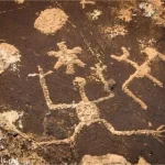
You’ll very quickly see why Nampaweap is special. The basalt rocks, which have fallen off the canyon wall, are literally littered with petroglyphs. There are many images of people and goats (the locals called this “Billy Goat Canyon” for a reason), as well as some geometric designs and I-don’t-know-what-all-else. This is considered the largest rock-art site on the Arizona Strip.
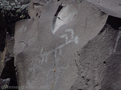
Part of what makes the images so special is that they are virtually untouched, and there are no glass panels protecting the art or fences keeping you away. This means you have to keep yourself away, which I didn’t find particularly hard. It’s easy enough to get close enough to see while not touching the art. A telephoto lens is nice, though, if you want pictures of some of the more distant / higher rock art.
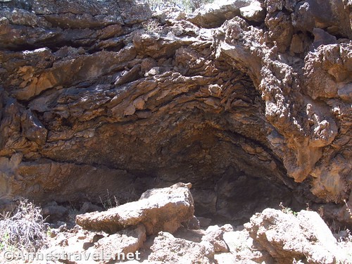
The canyon ends fairly quickly to the left, though it looks as though a lava tube might extend a few feet into the rock. I took the social trail downcanyon a short distance, but not seeing any more art, I turned around. If it had been cooler and we had more time, I probably would have explored further.
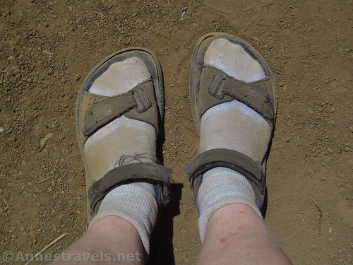
Coming back up to the parking lot, I took a picture of my socks, just to prove how dusty the trail is. Though in truth, the reason I hadn’t worn my hiking boots was because my socks were so dusty to start with, I didn’t want to put that much dust into my boots! The van didn’t look much better than my socks after all of the dusty dirt roads. Even the interior had a thin film of dust over everything.
Overall: This isn’t a place to go for a picnic to hang out, nor is it somewhere you can just drive to on a whim. It’s a place to be careful not to disturb, and you’d better be very prepared with water, gas, food, a good, high-clearance vehicle, a map, and survival skills should something go wrong. Still, if you can make it out there, you’ll be treated to hundreds of petroglyphs and a very pleasant little hike in the middle of nowhere.
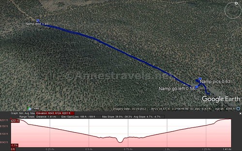
Round Trip Trail Length: About 1.5 miles. I ended at 1.45 miles, but that didn’t include a bit of exploring.
Net Elevation Change: 115ft. (6,136ft. at the trailhead to 6,021ft. at the petroglyphs)
Facilities: None
Fees: None
Trail Notes: Whatever else you do, do not deface, touch, or otherwise harm the petroglyphs! Do not remove anything from the area! Use extreme respect to protect them for future visitors. Also, be prepared for the driving experience to get here: rough roads that require no more than 35mph, extreme remoteness that means it’s highly unlikely you’ll have a cell signal, and bring plenty of gas, food, water, and survival equipment “just in case”.
Trail 
![]()
![]()
Road ![]()
![]()
![]()
Signs ![]()
![]()
Scenery ![]()
![]()
Would I go 100 miles out of my way for this? ![]()
Overall Rating: ![]()
![]()
Key GPS Coordinates for the Nampaweap Rock Art
Trailhead: 36.3556667°, -113.1198500° (N36° 21.340′ W113° 07.191′ / 36°21’20.4000″, -113°07’11.4600″) (6,136ft.) (0.0) (end 1.45)
Turn Left: 36.3547667°, -113.1098000° (N36° 21.286′ W113° 06.588′ / 36°21’17.1600″, -113°06’35.2800″) (6,025ft.) (0.58)
Petroglyphs: 36.3552333°, -113.1097333° (N36° 21.314′ W113° 06.584′ / 36°21’18.8400″, -113°06’35.0400″) (6,021ft.) (0.63)
The gpx file for the Nampaweap Rock Art can be downloaded – please note that this and the GPS Coordinates are for reference only and should not be used as a sole resource when hiking this trail.
Download GPX File size: 27.3 KB Downloaded 472 times
(Note: I do my best to ensure that all downloads, the webpage, etc. are virus-free and accurate; however, I cannot be held responsible for any damage that might result, including but not limited to loss of data, damages to hardware, harm to users, from use of files, information, etc. from this website. Thanks!)
Getting to Nampaweap
From the town Fredonia, head west on AZ-398W toward Hurricane and Pipe Spring National Monument. After 8.3 miles, turn left onto a well-defined dirt road (a brown sign before the road should point toward Toroweap, 61) signed as Antelope Valley Road. A fairly large dirt/gravel parking area along the road allows ORVers to unload their ORVs (must be highway legal, or you will get in trouble). (Alternatively: the road to Toroweap is 5.1 miles east of Pipe Springs National Monument.) From here on, the roads are all dirt and rocks; don’t drive more than about 30mph to keep your tires whole. Follow the road about 56 miles (if in doubt, follow signs for Mt. Trumbull) to about the border of the national monument. Here a road goes off on the right (straight goes to Toroweap; right goes to Mt. Trumbull; the coordinate is approximately 36.388957, -113.059599). Turn right toward Mt. Trumbull. After 3.7 miles of (almost exclusively) uphill driving, turn left on a good side-dirt-road with a sign for Nampaweap. A little over a mile later, a small side-road on left will take you to the parking area.
From St. George, it might be faster to drive to Pipe Springs National Monument and then follow the directions above (Google thinks so!), but you can also come in on a very scenic high clearance, possibly 4×4 route past the Mt. Trumbull Schoolhouse. To do so, drive south on I-15S. Take Exit 2 toward UT-7; stay in the left lane on the exit to stay left to cross the bridge and then continue straight on UT-7W. After 3.1 miles, take the exit (on right) toward River Road. Turn right at the end of the exit ramp to be welcomed to Arizona by the road becoming dirt. After driving south about 49.6 miles (staying right and following the signs for Mt. Trumbull when in doubt), arrive at the Mt. Trumbull Schoolhouse (junction is approx. 36.411836, -113.325387). This is a great place to take a break from driving, eat a picnic lunch, use the pit toilet, and/or check out the schoolhouse, swings, and see-saws. Turn left here, following the signs for Toroweap. After about a mile, stay right to continue up toward Mt. Trumbull for another 14.3 miles. Turn right on the road marked for Nampaweap. A little over a mile later, a small side-road on left will take you to the parking area.
Zoom map out to browse nearby hikes & places of interest
This Week’s Featured Product!
Maps are vital whenever you’re off the grid. This map includes roads and trails in Grand Canyon National Park, Toroweap, the Mt. Trumbull Wilderness, and Grand Canyon-Parashant National Monument.
One response to “Nampaweap Petroglyphs – The Best Rock Art in Arizona!”
[…] a whim, following an official map I had picked up at the schoolhouse, we walked to the Nampaweap Petroglyph Site. It’s by far one of the best I’ve seen; there are images scratched into the rock […]