

It’s long been one of my group member’s dreams to go to the bottom of the Grand Canyon. Even in the days when we were young and couldn’t hike very far, we trekked down as far as we could go (1.5 miles, I believe) on the Bright Angel Trail, and then down to Skeleton Point on the South Kaibab Trail a few years later. Getting close to the goal was definitely a joy – and the views were great, too.
Quick Stats
(Affiliate links are present on this page.)
Back in 2005, one of my group members finally found a way for us to fulfill this long-held dream by hiking the Lava Falls Route. We started out early, packed for the duration, scrambled and helped each other along, and we did it: we hiked to the bottom of the Grand Canyon. And it wasn’t half as hard as everyone said it would be. So when it looked like we were going to be in the vicinity of the Lava Falls Route in 2018, we thought we’d try it again.

Well, we didn’t quite make it to the river – I’m guessing we failed about 0.25 miles short. The biggest problem wasn’t that we weren’t prepared – the reason we got out of the canyon alive was that we were prepared. The problem was that 1) June is the wrong time of year to be hiking a south-facing slope into the Grand Canyon, and 2) the trail has changed remarkably in 13 years!

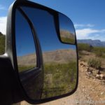
In 2018, we started right about sunrise on a cool morning in early June. Note that if you want to start early, you must stay at the Tuweep campground – which requires advance reservations (and limited group size). The gate into the Tuweep area is locked a little after sunset and doesn’t open again until sunrise, so the campground is your only option for a very early start. The road to the campground is much worse than 13 years ago – we really had no trouble back then in our Dodge Ram 1500 van (high clearance but no 4×4), but now we wished we had 4×4 and ended up rebuilding the road a little bit so our Ford E150 could make it up (and back down) the hill – which coming back out the next morning we were doing in the dark, because the road to the trailhead is before the really bad section of road.

There is a trailhead at the beginning of the access road. You can access this in a robust low clearance car (a Camry would be fine) as long as you take the road slowly. Many people park here and walk the two miles of the spur road down to the Lava Falls Trailhead. Back in 2005, there was space at the trailhead for half a dozen to a dozen vehicles; now it can hold about three or four. But since we were the only people there that day (I wonder why?), space wasn’t an issue.

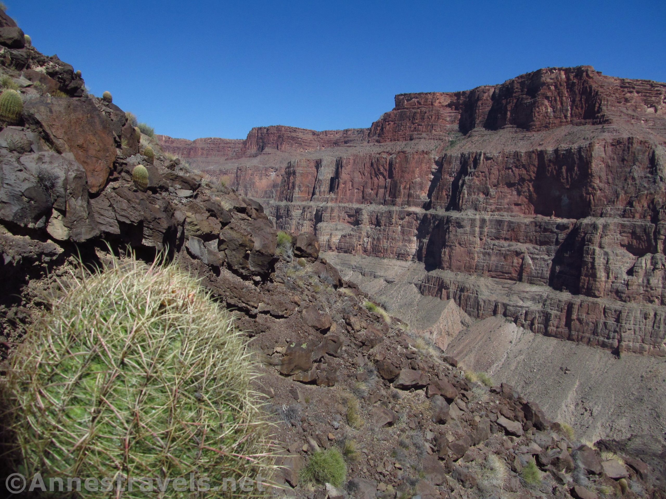
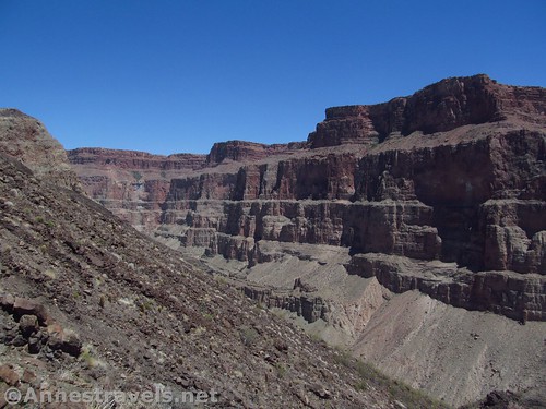
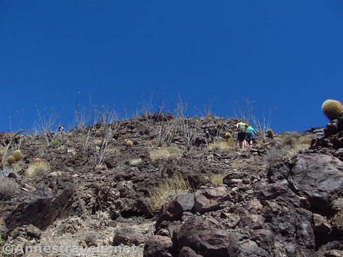
The trail, too, has changed, and at first it was so unfamiliar that we wondered if we were in the right place – there’s no trailhead sign, no permit box, nothing. Just a trail wandering off between the boulders. Follow the trail; it becomes a bit more official before too long. That said, this is a route, not a trail, so be ready to actually have to look for the trail and cairns that sometimes mark it. Also be ready for false trails and even two trails that might take you to the same place, eventually.

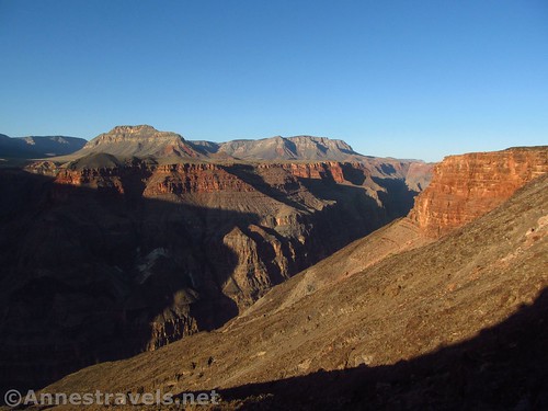
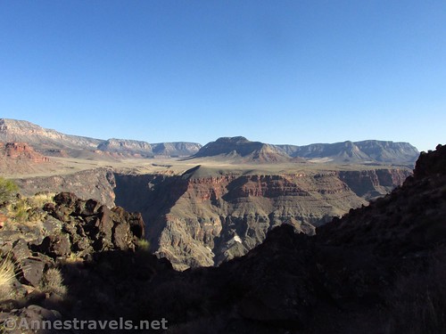
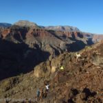
We so enjoyed the sunrise over the canyon. It’s a lovely sight; the rocks glowing with the early morning sunshine. We were still in shade, but the canyon was a web of shadows and light.
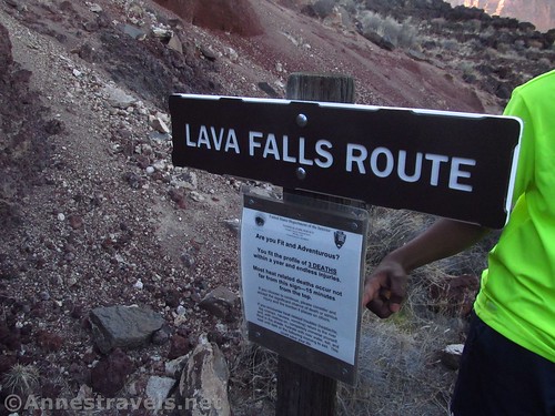
After 0.3 miles, we found the trailhead sign. There is a permit you’re supposed to fill out, and signs warn you about the dangers of the canyon. We did what we had to, and continued down the trail.

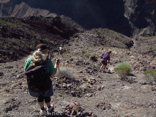
At times, the trail is quite easy to follow; other times, not so much. It’s easy enough when the trail crosses the desert, but at times, it crosses or even follows one of the multiple drainages that tumble down to the Colorado River. After we had hiked for a while, we missed the path rising out of the wash (I’ll blame it on looking for another good way to get my less-flexible group members down the next dryfall rather than looking for the cairns that sometimes exist and sometimes don’t and sometimes are misleading) and we got pretty lost.

I had a GPS track supposedly of the trail, but I don’t know where they got their data from, because it was most definitely wrong (it had us going down the wrong drainage, which, according to one of my group members who went over there, takes you to an impassible dryfall). So we blundered about for a bit and finally came on the trail again. Yay!
This all compared to 2005, when the trail wasn’t hard to follow, had plenty of scrambles that we did with ease, and it was a whole lot cooler! It was getting warm under those June skies!
The trail was slightly easier to follow in this section, which was a nice change of pace. Stopping to find the trail every 50ft. or less was getting old fast!
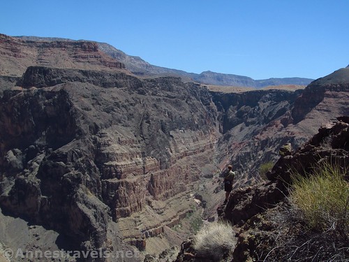
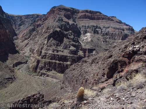
We followed the trail downward, but it eventually ended (more or less) at a sheer dropoff. We could see the cairns and trail where we were, and cairns down below, but we couldn’t easily find a way to get between the two. I think if we had actually tried, we could have done it. But some of my group members were not handling the heat well at all, and we knew we had to get out of there before anything worse than heat exhaustion set in.
So we turned around. But if you want to get down to the river, the section we couldn’t do is called “The Chute”. It’s a drainage full of scree; you’ll have to scramble down the loose scree, find the trail at the bottom, and you’re basically at the Lava Falls Rapids. Unless that’s changed, too, of course. Last time, The Chute was slippery but doable. One of my responsible older group members looked up in time to see one of the kids skateboarding down the scree chute like a pro – using a larger rock as a skateboard. She said it was an accident but that it was a fun way to descend quickly.

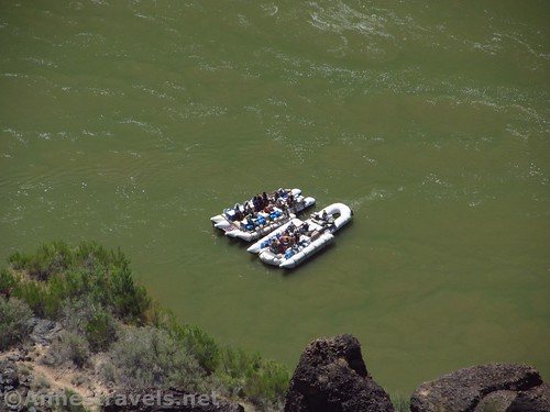
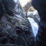
Down by the river are campsites and sandy beaches (no swimming; it’s far too dangerous). You can also watch rafts shoot one of the most exciting rapids in the Grand Canyon.
But we headed back up, stopped in the shade to rest and have something to eat, then continued on. We finally stopped and hid out the hottest part of the day in the shade of lava rocks (there’s not much shade on the trail and it’s a south-facing slope). I ended up sitting on a dead cactus in my shady spot (what can I say, it was in one of the very few places in the shade!), but I ended up none the worse for it.

Honestly, this is the closest we’ve ever come to dying in the desert. It was not a fun place to be, especially since I felt responsible for the rest of my group. We got out at all for two reasons: 1) I had come very well-prepared with water and food, and 2) God. Really, that second one is probably most of it.

We finally struggled for the top, and we arrived back up at the parking area a couple of hours before sunset. We lost the trail multiple more times on our way back up. So as you can see, we either needed to pay more attention or maybe it’s just a hard trail to follow. Add a little dehydration and 100+F temperatures to the mix, and maybe you can understand our distraction!

Overall? You must want an adventure to do the Lava Falls Route down into the Grand Canyon. The first time I said they hyped it, but now I think it’s fallen into enough disrepair that you might want to think twice before attempting it if you’re not used to desert scrambling and adventures – and definitely do it during a cooler season!
Round Trip Trail Length: About 3.0 miles; varies depending on the route
Vertical Change: 2,509ft. (4,181ft. at the parking area to 1,672ft. at the river – this was one of our errors in judgment; we figured we were 4,000ft. above sea level so it would be cooler, but we forgot about the elevation drop!)
Facilities: None at the trailhead. There is a restroom at the ranger station up the road, a restroom at the Toroweap Overlook, and a restroom and picnic tables at the Tuweep campground.
Fees: $35/vehicle/7 days to enter Grand Canyon National Park (National Park & Recreational Lands Passes and Grand Canyon Annual Pass also accepted). Additional fee to camp at the campground.

Trail Notes: Pack plenty of water for his hike – it’s a doozy! Because yes, you really are dropping 2,500ft. in 1.5 miles. And climbing back up the same. Also, realize that there are multiple trails at times (you can see that on my visual map below). Follow the cairns, but follow your better judgment even more. There is virtually no shade on this route, and it’s a south-facing slope, so expect to be in the sun all day long.
Weather Note: Spring and fall are your best bets for reasonable hiking conditions (March, April, October, & November). Summer brings monsoon rains, effectively blocking road access to the trailhead – not to mention it’s so hot that it can scorch lizards. Winter is snowy and icy, which can also cut off-road access.

Trail 
![]()
![]()
![]()
![]()
Road ![]()
![]()
Signs ![]()
![]()
Scenery
Would I go 100 miles out of my way for this?
Overall Rating: 
![]()
GPS Coordinates for the Lava Falls Trail
Beginning of Trail: 36.2114500°, -113.0836667° (N36° 12.687′ W113° 05.020′ / 36°12’41.2200″, -113°05’01.2000″) (4,160ft.) (ended 3.70)
Trailhead sign: 36.2086167°, -113.0834500° (N36° 12.517′ W113° 05.007′ / 36°12’31.0200″, -113°05’00.4200″) (3,863ft.) (0.32)
Turn Around: 36.2022667°, -113.0801833° (N36° 12.136′ W113° 04.811′ / 36°12’08.1600″, -113°04’48.6600″) (2,461ft.) (1.86)
Very approximate “where you might come out” by the river: 36.199526°, -113.077737° (36°11.97156′, -113°04.66422′ / 36°11’58.2936″, -113°04’39.8532″)

The gpx file for (as far as I got down) the Lava Falls Route can be downloaded – please note that this and the GPS Coordinates are for reference only and should not be used as a sole resource when hiking this trail. Also note that while I talked about getting lost in the text, I’ve more or less straightened it out in the GPS (minus a few places where there really are two trails).
Download GPX File size: 58.8 KB Downloaded 486 times
(Note: I do my best to ensure that all downloads, the webpage, etc. are virus-free and accurate; however, I cannot be held responsible for any damage that might result, including but not limited to loss of data, damages to hardware, harm to users, from use of files, information, etc. from this website. Thanks!)

Getting to the Lava Falls Trailhead
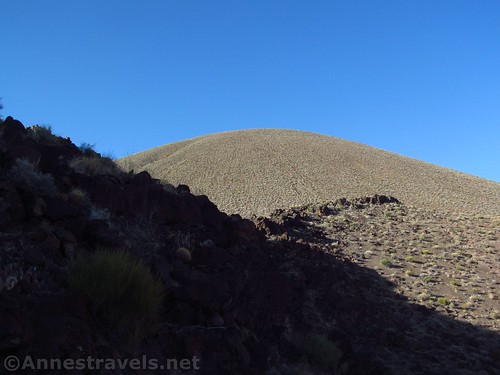
From St. George, drive south on I-15. Take Exit 2 toward UT-7; stay in the left lane on the exit to stay left to cross the bridge and then continue straight on UT-7 West. After 3.1 miles, take the exit (on right) toward River Road. Turn right at the end of the exit ramp to immediately cross the state line into Arizona. The road becomes dirt. Drive south about 38.5 miles, staying right when a road to a radio tower diverges left after about 14.3 miles. Stay right for another 8.1 miles and stay right again for another 3.1 miles to the Mt. Trumbull Schoolhouse. Turn left toward Toroweap or Tuweep (various signs say different things) and Mount Trumbull. Continue on this road 19 miles as it winds up and across the mountains, then back down into the next valley (stop along the way and see the Nampaweap rock art, if you want). Turn right to drive south on Hwy 115 for 7.6 miles to the ranger station; continue straight another 3.4 miles to the spur road that leads to the trailhead. This road is not well-signed, but if you see a sign saying that the road is 4×4 only ahead, you’ve gone too far. Turn right on the spur road and drive 2.4 miles to the trailhead in the shadow of the cinder cone known as Vulcan’s Throne. Note that this route is for 4×4 vehicles only (high clearance may be ok in good weather).
From a more easterly direction – and for a route that is passable by passenger cars – take the road to Toroweap southward (the road is along AZ-389 and is 5.1 miles east of the road to Pipe Springs National Monument and 8.3 miles west from the US-89A / AZ-389 junction in Fredonia). Drive south toward Toroweap about 27 miles (take it slow, about 30mph or less, to avoid flat tires – they say about 25% of visitors have a flat on the road). A “major” road will turn right here with signs for Mount Trumbull, etc. Continue south (straight) toward Toroweap another 7.6 miles to the ranger station; continue straight another 3.4 miles to the spur road that leads to the trailhead. This road is not well-signed, but if you see a sign saying that the road is 4×4 only ahead, you’ve gone too far. If you have low-clearance, park here and walk the 2.4 miles of the spur road to the trailhead. If you have high-clearance and 4×4, turn right on the spur road and drive 2.4 miles to the trailhead in the shadow of the cinder cone known as Vulcan’s Throne.

Spur Road Note: In good weather, the spur road is accessible by high clearance, 4×4 vehicles. We barely made it down with our Ford E150 van (high clearance but no 4×4; we had to rebuild the road in a couple of places beyond the lake bed). In poor weather, the road is impassable by any vehicle. Before driving across the lake bed, be sure it is hard – even 4×4 vehicles can’t make it through the mud if it is soft. When in doubt, walk! Because there’s no place to turn around on the spur road!

Zoom map out to browse nearby hikes & places of interest
This Week’s Featured Product!
The book is tiny – so tiny, the print is the same – but it covers more trails in Grand Canyon National Park than most other books on the market. With both popular and almost unknown routes, it’s a great book for those trying to get an idea of alternate hikes.

2 responses to “The Lava Falls Trail has Changed in 13 Years!”
[…] the Lava Falls Route in Grand Canyon National Park, […]
[…] on the Lava Falls Route, Grand Canyon National Park, […]