
How about a little bit of adventuring? It’s awesome to follow trails, but every once in a while, it’s also really fun to adventure: no trail, no social trail, just a map and a willingness to venture into the unknown.
Quick Stats
(Affiliate links are present on this page.)
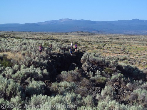
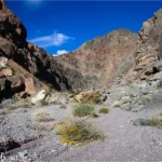
Such is the Big Crack in Lava Beds National Monument in far northern California (so far north, you might just have to sidetrack into Oregon to get there!) I saw a picture of someone exploring it on the Lava Beds Facebook page a couple years back, and immediately knew I wanted to go there. So, very early on a morning in July (who in their right mind would explore the above ground sections of Lava Beds in the heat of the summer? Answer: northerners who have little choice but to travel in July, lol) we set out from the park road directly across from where the East Wildlife Overlook access road meets the main road.
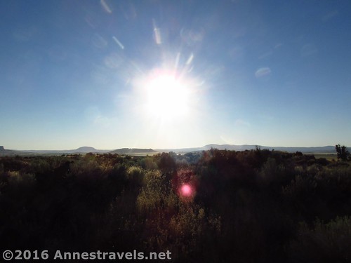
As you can see from the pictures, it was really early morning – we wanted to beat the heat of the noonday sun if we could.
What we should have done was walked slightly further east along the main park road – the Big Crack more or less goes right up to the road (it looks from the road like a bunch of volcanic rock). But as I either didn’t know that or didn’t remember it, we walked parallel to the Big Crack for a bit before heading east enough to discover the Crack.
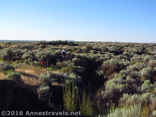
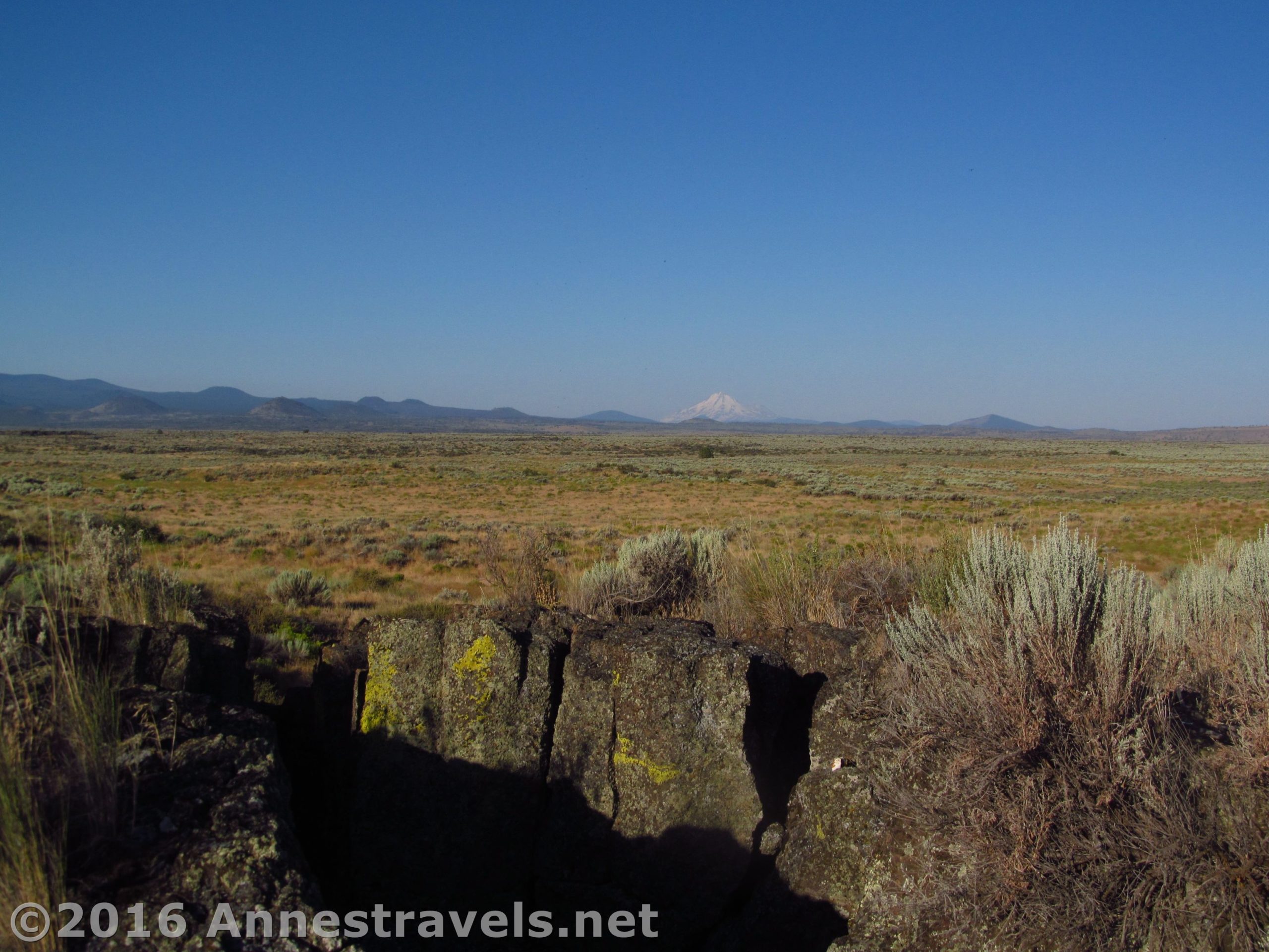
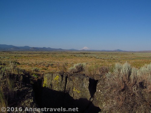
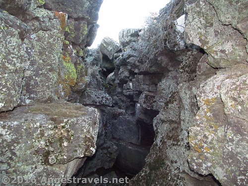
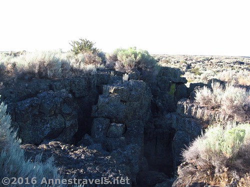
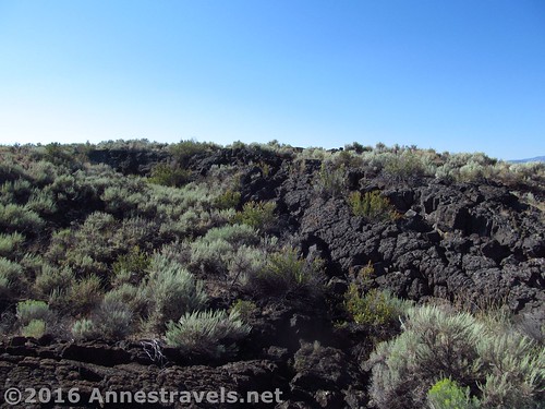
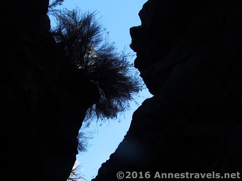
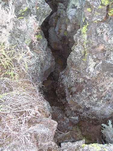
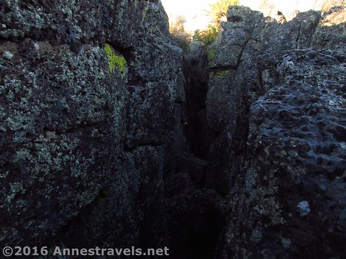
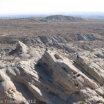
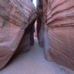
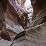
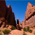
So just what is this Big Crack, and why was I so excited to explore it? The Big Crack was made when lava hardened over a fault line. Later, the plates around the fault shifted (probably during an earthquake) and the rocks split, creating a large “crack” in the earth. It’s interesting today for a couple reasons: 1) the exposed lava has created some pretty cool formations, and 2) the “crack” itself offers slot-canyon-like “caves” to explore. Pretty exciting, right?
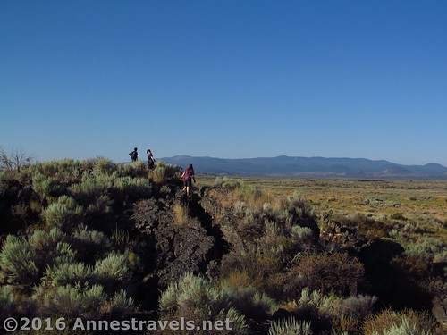
We explored along the Big Crack for a bit, then finally found a place we didn’t mind scrambling down inside. Only three of us descended – the others decided they were very happy to wait up top with the sage brush and fantastic rock formations.
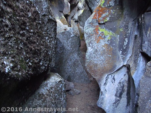
In the right circumstances, I think I could have very much enjoyed strolling along inside the Big Crack. But as it was, I was wearing shorts (no leg protection), there were bugs flying everywhere, and I was a little spooked by what I might find in there (spiders, rodents, etc. – after all, it would be a great place to get out of the summer heat, even if it wasn’t 8am yet). So I didn’t do as much exploring as I would have liked, just a bit of scrambling.
As a side note, you can’t just walk through the Crack. Rocks have fallen inside in a number of places, and other times the rock didn’t split in a straight line. So if you want to literally walk through the Crack, you’ll have to do quite a bit of scrambling. Some scrambling will be required if you want to walk along the rim (watch your step!), but it’s often not too hard to walk around any large obstacles on the rim.
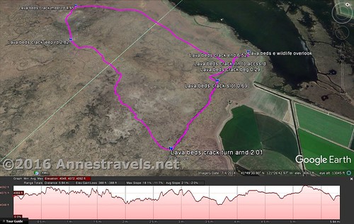
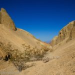
After 2 miles of scrambling along the edge of the Big Crack, right at a place where the lava spreads west as well as north-south, we decided we’d had enough. I could see from my GPS and map that there was a trail (the Lyons Trail) if we struck west.
Looking back, we should have just returned the way we came, albeit a bit to the west for easier walking. It would have been shorter, easier, and have been far less exciting. But since we did decide to find the Lyons Trail, we got to experience the northern Californian desert like never before.
The general idea is that you want to head due west, but a little to the south – the Lyons Trail takes a curve right about here, so heading south as well as west will ensure you don’t end up paralleling the trail while bushwacking through the desert, like we did (reason #1 we should have just gone back up the Big Crack).

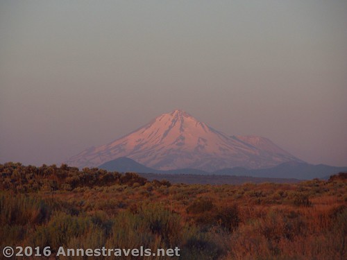
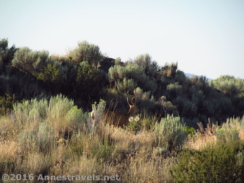
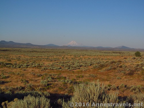
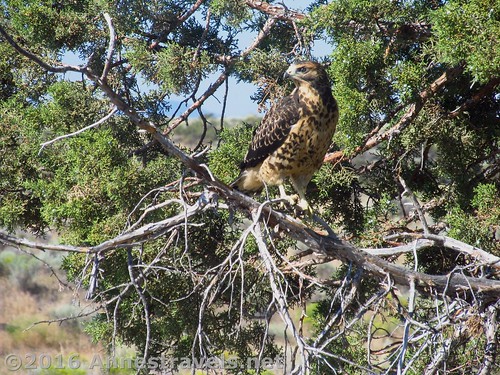
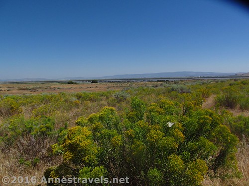
Probably the best part of going through the desert was the views toward Mt. Shasta. The views were pretty good from the Big Crack, but these were even better. The flora and fauna was also interesting – we ran across a rattlesnake (reason #2 we should have gone back via the Big Crack), a hawk in a lone evergreen tree (looking at the rattlesnake, I think – it certainly wasn’t interested in us), several desert bushes in bloom, cacti, and a lot more.
We finally arrived at the Lyons Trail (it looks like an old jeep road) 0.8 miles later (you could make this a bit shorter if you headed further south than I did). Turn right on the road and head north until it T’s at the main park road at mile 4.4. By this time, the sun was well up and it was getting to be very hot and dry. We decided that some of us would hoof it back to the East Wildlife Overlook along the main park road and bring the van back to the others, who would wait at the Hospital Rock viewpoint, which was nearby.
Turn right on the main park road – it’s another 1.8 miles back to the East Wildlife Overlook access road; then turn up the access road a quarter mile back to the parking area.

On the way, a park ranger stopped to make sure we were ok. They ribbed us a bit that we’d left the rest of our group and they were getting thirsty (to which I replied that I doubted it; we’d left them lots – apparently the elderly ranger thought that funny), but they let us go on our way when we explained what we were up to and that we had plenty of food and water with us. That said, I do think they were relieved later to see all of us drive by in the van.
Overall? This isn’t a hike for the faint of heart. But if you’re used to roughing it in the extreme desert wilderness, bring plenty of food and water and a good map, it’s highly unlikely you’ll get lost… and you’ll see a part of the park most visitors don’t know exist.
Make sure you check out Lava Bed’s Caves, too – they’re pretty epic!
Round Trip Trail Length: 4 miles to 6.25 miles depending on how you go – you could easily extend the hike further down the Big Crack (at a cooler time of year, hopefully)
Net Elevation Change: 77ft. (4,006ft. at the East Wildlife Overlook to 4,083ft. where I left the Big Crack)
Facilities: None. There’s not even a restroom at the East Wildlife Overlook.
Fees: $15 per vehicle to enter the park. Lava Beds Annual and Interagency Passes (America the Beautiful, Senior, Golden Age, Access, Golden Access, Volunteer, Military, Every Kid in a Park, etc.) also accepted.
Trail Notes: There is no trail, and the terrain is rocky and uneven. Watch your step!
Trail 
![]()
![]()
![]()
![]()
Road
Signs ![]()
![]()
![]()
![]()
Scenery ![]()
Would I go 100 miles out of my way for this? ![]()
![]()
Overall Rating: ![]()
![]()
Key GPS Coordinates for the Big Crack
East Wildlife Overlook: 41.83479N / -121.43926W (41° 50′ 5.2434″ / -121° 26′ 21.3360″) (4,006ft.) (0.0)
Trail beginning: 41.83149N / -121.44034W (41° 49′ 53.3640″ / -121° 26′ 25.2240″) (4,067ft.) (0.29; ended 6.52)
Slot: 41.82827N / -121.44067W (41° 49′ 41.7720″ / -121° 26′ 26.4114″) (4,078ft.) (0.69)
Turn away from the Big Crack: 41.81818N / -121.44036W (41° 49′ 5.4474″ / -121° 26′ 25.2954″) (4,083ft.) (2.01)
Jeep Road (Lyons Trail): 41.82521N / -121.46661W (41° 49′ 30.7554″ / -121° 27′ 59.7960″) (4,048ft.) (2.82)
Jeep Road (Lyons Trail) meets Park Road: 41.83142N / -121.47352W (41° 49′ 53.1120″ / -121° 28′ 24.6714″) (4,052ft.) (4.45)
Return to the East Wildlife Overlook Access Road: 41.83160N / -121.44043W (41° 49′ 53.7600″ / -121° 26′ 25.5480″) (4,067ft.) (6.25)
The gpx file for my explorations around the Big Crack can be downloaded – please note that this and the GPS Coordinates are for reference only and should not be used as a sole resource when hiking this trail.
Download GPX File size: 163.4 KB Downloaded 500 times
(Note: I do my best to ensure that all downloads, the webpage, etc. are virus-free and accurate; however, I cannot be held responsible for any damage that might result, including but not limited to loss of data, damages to hardware, harm to users, from use of files, information, etc. from this website. Thanks!)
Getting to the East Wildlife Overlook
From I-5, take Exit 748; turn north on US-97N. Take this road 53 miles, then turn right onto CA-161E (the views of Mt. Shasta along US-97 are terrific!) After 19.3 miles, turn right onto CA-139S for 8.0 miles, then turn right on County Road 111 5.7 miles. (You’ll be in Oregon for a short time during this section of road.) Turn right on County Road 120 1.8 and turn right onto the access road for the East Wildlife Overlook.
If you’re coming from the east, drive to Altruas, CA (where US-395 meets CA-299). Turn onto CA-299W for 18.7 miles, then turn right onto CA-139N for 47.0 miles. Turn left onto County Road 111. After 5.7 miles, turn right on County Road 120 for 1.8 miles and turn right onto the access road for the East Wildlife Overlook.
Zoom map out to browse nearby hikes & places of interest
This Week’s Featured Product!
With 125 day hikes of various skill levels and areas in northern California, this book is a great resource. It also includes several trails in Lava Beds National Monument.
One response to “Exploring the Big Crack in Lava Beds”
[…] the next morning we explored the “Big Crack”, a faultline that split, revealing a kind of rock slot canyon (pretty […]