

I only did one real slot canyon in Utah last fall (that doesn’t count Resurrection Canyon and Wiregrass Canyon, which I did earlier in the trip, but which weren’t very slot-y). Round Valley Draw was introduced to me as being “on par with Little Wildhorse Canyon” and “one of the best non-technical canyons in Grand Staircase-Escalante National Monument.” My take is probably not quite so glowing, but it was a very fun way to spend Thanksgiving afternoon last November. As for being non-technical, it’s one of the few slot canyons where I’ve used a rope… though it wouldn’t have been necessary except for lowering my pack down a few drops.
Quick Stats

We started out the hike on the totally wrong foot (which is what I’ll blame for the fact that we arrived back at the trailhead in the dark). My directions told me to “follow the road,” so I did. The only trouble was that we were supposed to drop into the wash and follow what was, at one time, a road and now is just a streambed. Instead, we ended up continuing on the rough dirt road that veers left at the trailhead. And while it had some good views, and we did eventually get back to the right place by descending cow trails on a steep hillside (GPS coordinates for the win!), it’s not exactly how I would recommend hiking Round Valley Draw!

The first adventure is getting to the trailhead. The road in is pretty good for a while, then crosses some sandy washes. We were ok in our high clearance, 2WD van, but I could see how this could be more difficult in other seasons. If you don’t have high clearance, you’ll want to stop at one of the pulloffs before crossing the wash.
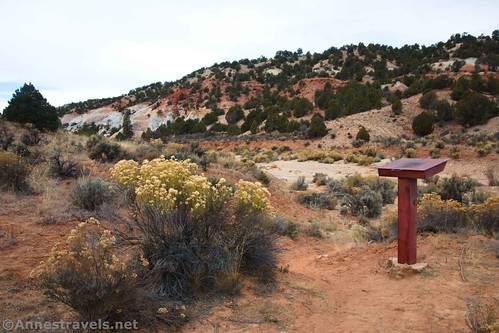
Once at the parking area, head over to the trail register on the side of the wash. Then follow the trail to drop into the wash and turn left (I’m pretending we did this right… which we didn’t, as I described above). The wash here is wide and fairly easy walking as long as you don’t mind hiking on loose rocks.

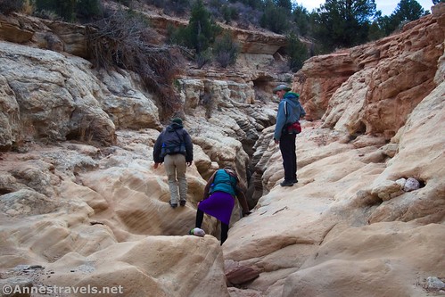
After about 0.7 miles, the wash suddenly goes over the lip of a small dryfall (small, as in short; it pretty much goes the width of the wash). This would have been the end of the old road. Scramble down and continue another quarter mile to where you can drop into Round Valley Draw narrows.

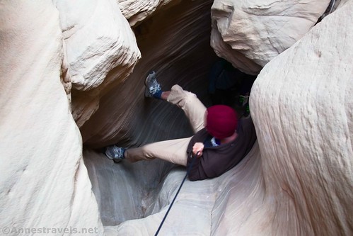
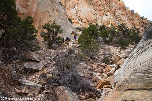
This drop was the most difficult part of the canyon for my group. Small children would probably have issues with it. One of my group members scrambled down and then back up, to show it could be done, and then he helped the rest of us using a lightweight climbing rope that I “just happened” to have in my pack (actually, I’d packed it just in case).
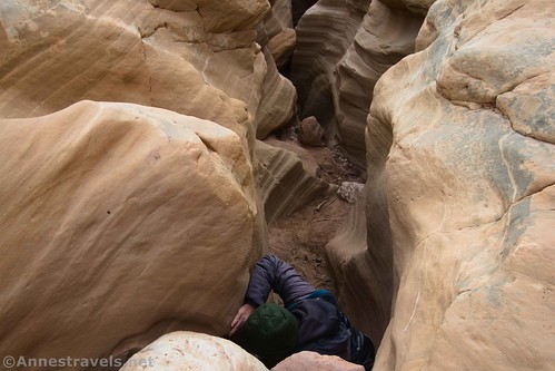
I used the rope to drop my pack over the edge of the drop before going down, myself. There seemed to be two ways down – one at the head of the drop (which presented a couple of complicated moves) and a second one if you walk to the right of the narrow slit in the canyon for a short distance (this was how I dropped my pack down – through this slit).
The real thing is to take stock, make smart choices based on your skill level and what looks easiest to you, and then to go for it! I could totally have done it without a rope, but it seemed like good practice.
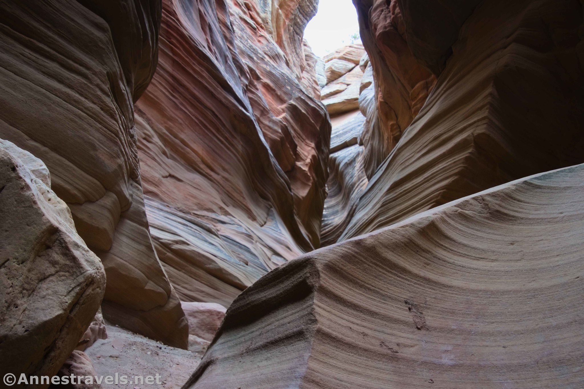
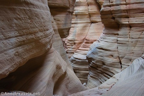
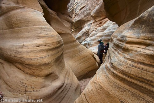
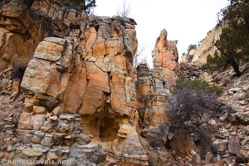
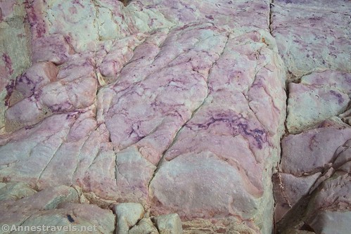
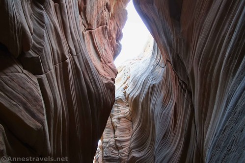
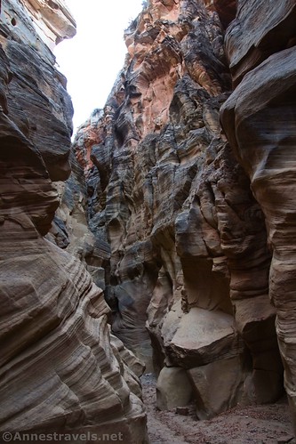
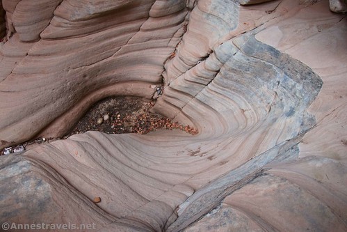
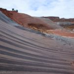
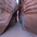
Once down the first drop, the downcanyon route is a mix of easy walking and small dryfalls/choke stones. I didn’t take many notes; just a lot of photos of the canyon walls towering above me and so many swirls and lines in the rocks. This was the best part of Round Valley Draw to me – all of the lines and textures in the walls.

I felt that the first set of narrows was the prettiest, though there were others that were pretty and fun, too.
The canyon descends at a fairly gradual rate with sections of narrows, dryfalls, chokestones, and general fun. One obstacle was exciting enough (there just wasn’t much in the way of handholds!) that I again used the rope to drop my pack about 6 or 8 feet into the next section of canyon.

A tall dryfall on the right (up to the rim of the canyon) was also spectacular about a half a mile beyond where I dropped into the narrows of Round Valley Draw.
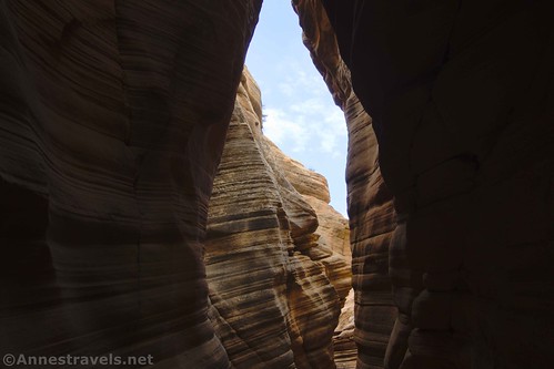
For better or for worse, it wasn’t a sunny afternoon. Nor was there rain anywhere nearby (that night it snowed at least 6 inches in Cedar City, so the storm was moving in). My pictures are a little drab. But then again, the canyon itself wasn’t very colorful. And at least I didn’t have to deal with the dynamic contrast of bright sunlight vs. dark shadows.
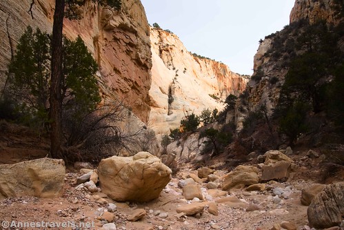
Almost 3 miles after dropping into the narrows of Round Valley Draw (give or take a little – my GPS doesn’t always love slot canyons), the narrows suddenly open up into a broader canyon. This is not the first time the canyon has broadened, but it is the first time there is a side canyon on the right that looks climbable. While I’m sure there’s more to explore, it was also getting on in the afternoon. So we took the traditional route (side canyon) on the right to exit Round Valley Draw.

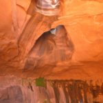
The exit route is little more than a social trail up a side canyon. It’s rocky, sketchy, and not a whole lot of fun. But we did see an arch about a quarter mile up the route!
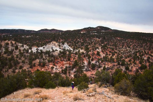
Reach the rim of the canyon about 0.3 miles from the canyon bottom. There was a social trail here heading generally northeast, but it peters out into any number of social and animal trails. Staying nearer to the canyon rim seemed to produce more trails and less grass. We made our way northeast and finally picked up a decent track that took us to where the trail suddenly turned right to descend into the canyon (a little over a mile from where you exited the side canyon).

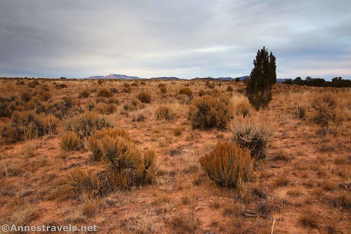
This would be a beautiful area on a sunny day. As it was, we made our way down the steep slope, crossed a wash, and continued to follow the trail as it wound its way over/around another hill before dropping us back into Round Valley Draw near an old gate.
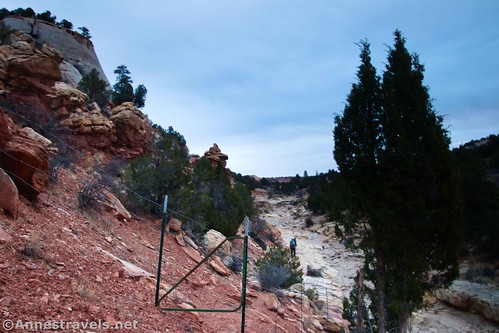
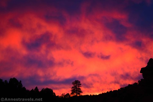
The trail comes out just above where you dropped into the narrows. So it’s a simple matter of turning left (upstream) and hiking back to your vehicle. However, it was getting dark for us – so we enjoyed a glorious sunset at our backs on our way to the trailhead!

Round Trip Trail Length: My GPS says that I did about 6.3 miles without all of my wanderings on dirt roads before dropping into the draw. With my shenanigans, it was 7.4 miles.
Elevation Gain: My GPS got pretty confused in the canyon, and with that and my detours, it’s hard to say for sure. But I’d guess it’s in the realm of 1,160ft. (6,268ft. to 5,825ft.)
Facilities: None
Fees: None
Trail Notes: Be sure to check out Grosvenor Arch while you’re in the area. This is a very technical trail for being non-technical – in other words, you don’t necessarily need a rope, but you’ll want to be up for some good scrambles/chimneying. I was a little disappointed that it wasn’t more colorful and the rocks weren’t more photogenic, but it’s still a great hike. Also, note that you now need a free permit in order to disperse camp in Grand Staircase-Escalante – I don’t know much about it beyond the need since the ranger station was always closed whenever I stopped in (hours and holidays).
Trail 
![]()
![]()
![]()
![]()
Road ![]()
![]()
![]()
Signs ![]()
![]()
![]()
![]()
Scenery ![]()
![]()
Would I go 100 miles out of my way for this? ![]()
![]()
Overall Rating: ![]()
![]()
![]()
GPS Coordinates for Round Valley Draw
Not TH (this is the dirt road – use the “end” coordinates for the TH): 37.4559760°, -111.9010420° (37°27.35856′, -111°54.06252′ / 37°27’21.5136″, -111°54’03.7512″) (6,105ft.) (0.0)
(After this, I followed the dirt road for a while)
Water tank: 37.4541710°, -111.9014710° (37°27.25026′, -111°54.08826′ / 37°27’15.0156″, -111°54’05.2956″) (6,117ft.) (0.13)
Road junction (I went right): 37.4475270°, -111.9022430° (37°26.85162′, -111°54.13458′ / 37°26’51.0972″, -111°54’08.0748″) (6,277ft.) (0.67)
End of road; turn right: 37.4484030°, -111.9062370° (37°26.90418′, -111°54.37422′ / 37°26’54.2508″, -111°54’22.4532″) (4,283ft.) (0.95)
(After this, we headed downhill following animal trails. We eventually landed in Round Valley Draw a short distance above the first dryfall.)

Enter Round Valley Draw: 37.4538770°, -111.9095170° (37°27.23262′, -111°54.57102′ / 37°27’13.9572″, -111°54’34.2612″) (6,048ft.) (1.48)
Dryfalls (go down into the narrows): 37.4526620°, -111.9121370° (37°27.15972′, -111°54.72822′ / 37°27’09.5832″, -111°54’43.6932″) (6,032ft.) (1.72)
Side dryfall: 37.4509760°, -111.9151040° (37°27.05856′, -111°54.90624′ / 37°27’03.5136″, -111°54’54.3744″) (5,993ft.) (2.27)
Side canyon up: 37.4447850°, -111.9260520° (37°26.68710′, -111°55.56312′ / 37°26’41.2260″, -111°55’33.7872″) (5,805ft.) (4.87)
Arch: 37.4461410°, -111.9266980° (37°26.76846′, -111°55.60188′ / 37°26’46.1076″, -111°55’36.1128″) (6,007ft.) (5.08)
Rim: 37.4465730°, -111.9257780° (37°26.79438′, -111°55.54668′ / 37°26’47.6628″, -111°55’32.8008″) (6,199ft.) (5.25)
Plain: 37.4503120°, -111.9211340° (37°27.01872′, -111°55.26804′ / 37°27’01.1232″, -111°55’16.0824″) (6,228ft.) (5.70)
Begin down: 37.4549640°, -111.9150970° (37°27.29784′, -111°54.90582′ / 37°27’17.8704″, -111°54’54.3492″) (6,260ft.) (6.31)
Fork: 37.4538980°, -111.9138470° (37°27.23388′, -111°54.83082′ / 37°27’14.0328″, -111°54’49.8492″) (6,094ft.) (6.44)
Gate: 37.4533850°, -111.9111840° (37°27.20310′, -111°54.67104′ / 37°27’12.1860″, -111°54’40.2624″) (6,046ft.) (6.71)
End: 37.4561210°, -111.9011330° (37°27.36726′, -111°54.06798′ / 37°27’22.0356″, -111°54’04.0788″) (6,099ft.) (7.41)
The gpx file for Round Valley Draw (including my little detour on the dirt roads) can be downloaded – please note that this and the GPS Coordinates are for reference only and should not be used as a sole resource when hiking this trail.
Download GPX File size: 125.3 KB Downloaded 497 times
(Note: I do my best to ensure that all downloads, the webpage, etc. are virus-free and accurate; however, I cannot be held responsible for any damage that might result, including but not limited to loss of data, damages to hardware, harm to users, from use of files, information, etc. from this website. Thanks!)
Getting to the Round Valley Draw Trailhead
There are two basic ways to get to the trailhead road. The first (from the north – definitely the better/easier way to come in) is to turn off of UT-12 in Cannonville, 4.7 miles south of Tropic, Utah or 3.5 miles west of Henrieville. Either way, turn onto Kodachrome Road and drive 7.2 miles; continue straight onto Cottonwood Canyon Road for 6.7 miles. This is a dirt road, but it should be suitable for most vehicles in dry weather. At about 37.4770017, -111.8874769, turn right, following the sign for Round Valley Draw. The road worsens at this point; you may want to park (out of the way of traffic) at some point along the road and walk the final 1.7 miles to the trailhead, especially if you don’t have high clearance. 4×4 is recommended for driving all of the way to the trailhead, but I did it (at least on that visit!) with only 2WD.
The second way in is from the south. It requires high clearance and is a long (if mostly scenic) drive on a dirt road. It begins on US-89 at approximately 37.1049581, -111.8468709, 46 miles east of Kanab/3.1 miles east of the Paria Contact Station and 10.2 miles west of Big Water. Turn north onto the Cottonwood Road, signed for Grosvenor Arch and Kodachrome Basin State Park. The road slowly makes its way north along the Paria River and then through desert, canyons, and rock formations. After 32 miles (2.8 miles after passing the sign to Grosvenor Arch), turn left at the sign for Round Valley Draw (approx. 37.4770017, -111.8874769). The road worsens at this point; you may want to park (out of the way of traffic) at some point along the road and walk the final 1.7 miles to the trailhead, especially if you don’t have high clearance. 4×4 is recommended for driving all of the way to the trailhead, but I did it (at least on that visit!) with only 2WD.

Explore More around Grand Staircase-Escalante National Monument
Nearly 60 different adventures are showcased in this comprehensive guidebook to the region around Grand Staircase-Escalante National Monument. Arches, canyons, views, rock formations, history, and more can be found within its pages. Buy your copy here!


One response to “Exploring Round Valley Draw”
[…] sure there were more things to discover, but we wanted to check out Round Valley Draw before the day was […]