There’s nothing quite like climbing Coffin Peak in the Black Mountains of Death Valley to see the Funeral Mountains. That’s just too much of a single theme if you ask me! But it’s actually a fun off-trail trek, without too much opportunity to get lost and with fantastic views and almost complete solitude. So if you happen to be at Dante’s View and want an extra adventure, it’s a good option.
Quick Stats
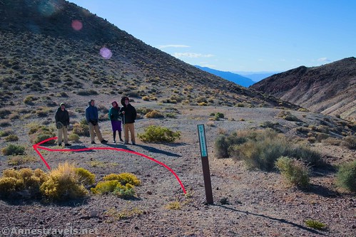
The route begins at the trailer parking (near the restroom) 0.5 miles below Dante’s View (which means that it’s along a paved road). I started near the Wilderness Boundary post. Turn left to walk downhill into the wash (the valley going down to Badwater should be on your right and behind your back). Walk up the wash (it’s really just a desert valley) for almost 0.2 miles.
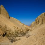
At this point, the flat-ish land that you’ve been walking along on your left dips slightly and then rises in a hill above you. At the same time, the wash you’ve been following turns sharply to the right. You want to leave the wash by scrambling up the hill to the left (heading pretty much due east).

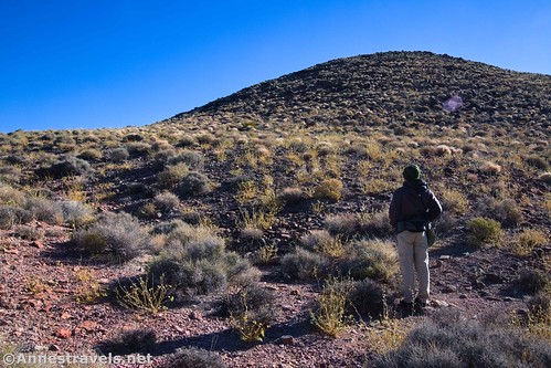
You’ve now completed the most difficult part of route finding on your way up Coffin Peak. You’re also coming to the most difficult section in the way of hiking. On our way back, we found a sparsely-cairned route that would have taken us up the northwestern face of this hill. On our way up, we headed pretty much straight up toward the ridgeline. Remember to try to travel on durable surfaces, like rock and gravel, rather than on the vegetation that is struggling for survival.

The route rises up and then heads south (to the right). We didn’t quite rise up to the ridgeline, but instead stayed lower almost until the ridge veers east again. The rocks in this area were somewhat sketchy, so use caution.
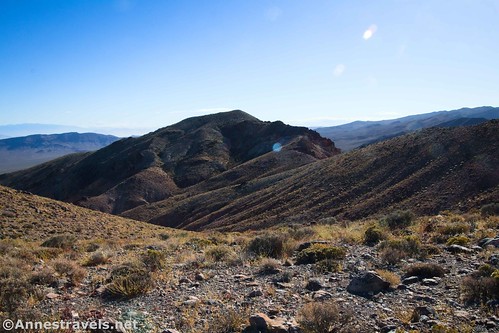
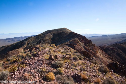
Once on top of the first hill, head slightly south (right) to follow the ridgeline as it turns east again toward Coffin Peak. There is one narrow section of ridge, but the good news is that we picked up a trail here. Yay!
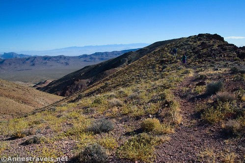
From there it was a quick and easy bit of striding up to the top of Coffin Peak!
I was very surprised when we arrived. I had GPS coordinates, but somewhere along the way, I’d misjudged my mileage and thought it was twice as far as it turned out. I’d rather have it that way than the other!
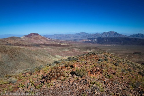
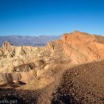
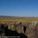
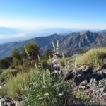
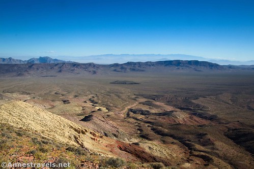
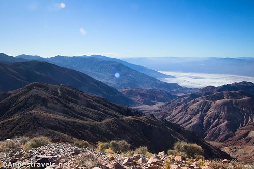
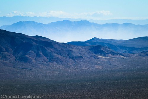
The views from Coffin Peak are spectacular, and they really are different from Dante’s View. The latter mostly gives you views down into Badwater, and while you can see bits of Death Valley from Coffin Peak, you get a better view over the Black Mountains (south). You can also see into Greenwater Valley and the Greenwater Range (east) as well as north to the Funeral Mountains. Because we visited in November, and the sun was very far south, this was the easiest direction to take photos. There is also a good view to the Panamint Mountains (west).
The canyon to the south is aptly-named Coffen Canyon. There is also a very unique rock pillar in this direction – it reminded me of a petrified tree stump, but I’m pretty sure that was just my imagination.

After enjoying the view, retrace your steps back to the parking area. The good news is that it’s even easier to find your way on the trip back – that’s a win for sure!

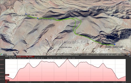
Round Trip Trail Length: I went 2.7 miles
Elevation Gain: 901ft. (5,117ft. to 5,508ft.)
Facilities: Vault toilet at the trailhead
Fees: $30/vehicle to enter Death Valley National Park, valid 7 days. America the Beautiful National Parks & Federal Lands passes and Death Valley Annual Passes are accepted.
Trail Notes: There is very little in the way of a trail on this hike, so be ready to go cross-country and do a bit of way-finding. One area has sketchy rocks underfoot. While it’s certainly not an official route, it is popular enough that the rangers are aware that it’s somewhat frequently visited. That said, chances are that you’ll have the entire hike (after leaving the parking area) to yourself – solitude reigns!

Trail 
![]()
![]()
![]()
![]()
Road ![]()
Signs ![]()
![]()
![]()
![]()
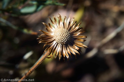
Scenery
Would I go 100 miles out of my way for this? ![]()
Overall Rating: ![]()
![]()
GPS Coordinates for Coffin Peak
TH: 36.2175770°, -116.7224800° (36°13.05462′, -116°43.34880′ / 36°13’03.2772″, -116°43’20.9280″) (5,162ft.) (0.0)
Turn out of wash to ascend to ridge: 36.2173430°, -116.7197750° (36°13.04058′, -116°43.18650′ / 36°13’02.4348″, -116°43’11.1900″) (5,113ft.) (0.17)
Coffin Peak: 36.2144050°, -116.7057900° (36°12.86430′, -116°42.34740′ / 36°12’51.8580″, -116°42’20.8440″) (5,487ft.) (1.37)
End: 36.2175390°, -116.7223470° (36°13.05234′, -116°43.34082′ / 36°13’03.1404″, -116°43’20.4492″) (5,159ft.) (2.66)
The gpx file for Coffin Peak can be downloaded – please note that this and the GPS Coordinates are for reference only and should not be used as a sole resource when hiking this trail.
Download GPX File size: 71.8 KB Downloaded 351 times
(Note: I do my best to ensure that all downloads, the webpage, etc. are virus-free and accurate; however, I cannot be held responsible for any damage that might result, including but not limited to loss of data, damages to hardware, harm to users, from use of files, information, etc. from this website. Thanks!)

Getting to Coffin Peak Trailhead
From Furnace Creek, drive east (toward Badwater Road) on CA-190. About 10.7 miles after the Badwater Road goes off on the right (stay on CA-190 at this junction), the road to Dante’s View will go off on the right. Turn up this road for 12.6 miles to the restroom on the left. Trailers must park here, but there’s nothing stopping others from using the parking area for an hour or two while they hike Coffin Peak.

From Death Valley Junction (near the Amargosa Opera House), turn onto CA-190 toward Death Valley National Park. After 18.1 miles, turn left onto the road up to Dante’s View. The parking area will be on the left after 12.6 miles (it’s beside the restroom). Trailers must park here, but there’s nothing stopping others from using the parking area for an hour or two while they hike Coffin Peak.
Even More Fun Hikes in Death Valley!
If you want some of the less-known Death Valley gems, check out this book. It covers 280 hiking and driving destinations, not to mention history, topo maps, and more. Buy your copy here.