

The number one adventure I wanted to hike when I found myself in Death Valley last fall was the Red Cathedral Canyon Crest. It’s not an official trail, but I personally know people who have hiked it and loved the views (I loved their photos!) We messed around trying to find it for close to half a mile, so hopefully I can help you hike it more easily. While it’s not all that difficult to find, and it’s definitely not hard to follow, there are some sketchy places that require steady feet and an enjoyment of heights – so be ready for an adventure!
Quick Stats
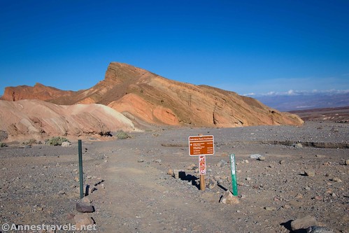
The trailhead for Red Cathedral Canyon Crest is the Zabriskie Point parking area. But instead of hiking up the paved path to the viewpoint (you’re welcome to do that, too!), walk right to the beginning of the Badlands Trail. Hike the Badlands Trail 0.1 mile to where it passes through a “hole” in the badland wall. Instead of hiking through the “hole,” turn right to scramble up the badlands wall.
I got confused here and turned right along the base of the badland wall. It was a nice hike, a little gravely, with good views. I finally turned around and scrambled up a very steep watercourse to the ridgeline. Don’t be like me; follow my directions above!
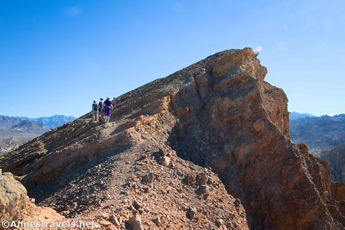
The scramble up the badland wall is a little sketchy, definitely Class 3, especially in one place that looks like a dryfall. But once on top, the views immediately become excellent and the path is easier to hike (no more than mild Class 2 in most places).
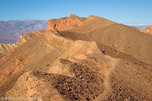
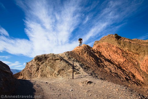
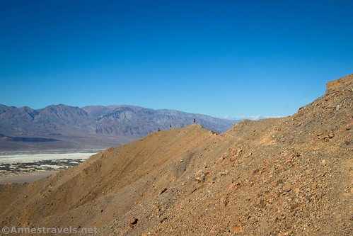
The trail is well-trodden – you’re just hiking along the ridgeline, so it’s hard to get lost. At times, social trails go off on the left to rise up to various high points on the ridgeline. You’re welcome to check out these viewpoints or choose any of them as your turn around point.
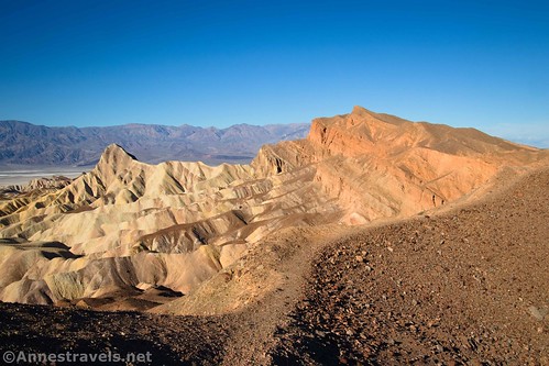
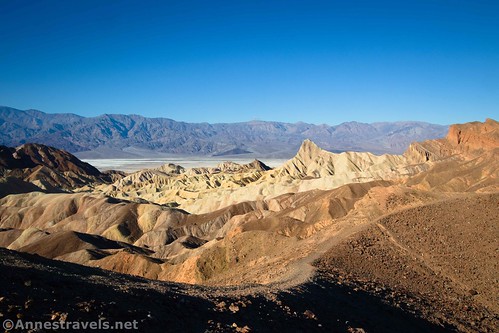
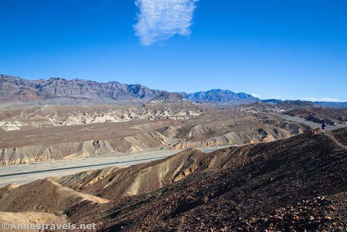
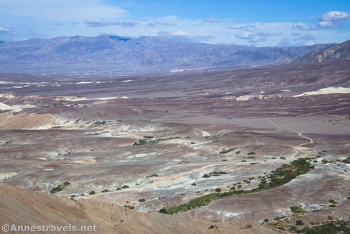
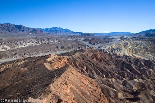
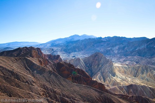
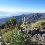
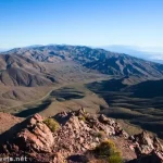
Views from the ridgeline are awesome. To the north are the Funeral Mountains (including Echo Canyon and Hole in the Wall) across the main park road (CA-190).
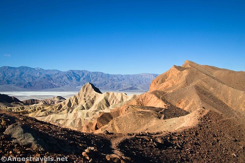
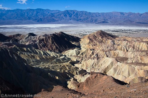
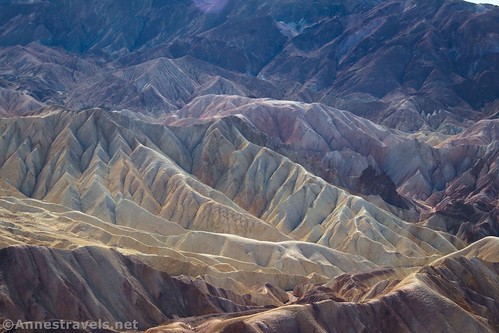
To the south and east are the badlands below Zabriskie Point. Wow!

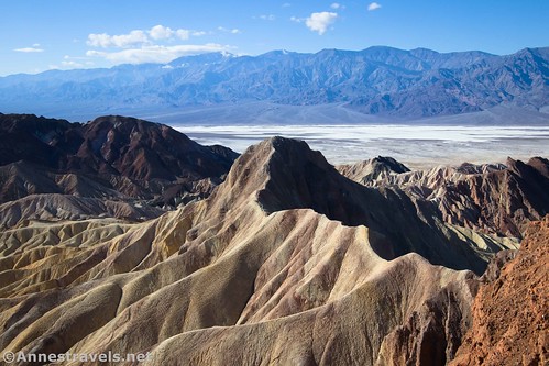
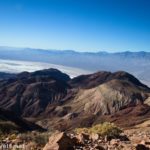
Looking south and west, Badwater Basin comes more and more into view over Golden Canyon. The Panamint Mountains are also very visible, especially on a clear day.

At first, Manly Beacon dominates a lot of the view, but eventually, you’ll pass it by (there is a trail that goes off up to the top of the beacon, but I decided it looked too sketchy for me!)
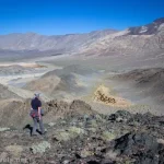
The trail reaches a high point about 1.2 miles from the trailhead. This is a great turn-around spot, as it has fantastic views. But to continue, keep hiking on the social trail along the ridgeline.

The trail after the high point is sketchier; while before you might find narrow places, this has more sections of easy scrambling or loose rocks in narrow places. I helped one or two of my group members across a couple of areas with loose stones.
We finally turned around about 2.0 miles from the parking lot, just after the sketchiest trail yet (it goes along the left side of the hill and is loose and gravelly). It doesn’t sound very long, but there were so many views that it felt like a longer ramble. At this point, the social trail was heading downhill and the views were diminishing. So while you can keep going, it seemed to us like a good place to eat a snack and head back!
Round Trip Trail Length: Up to 4.0 miles
Elevation Gain: Up to 1,223ft. (596ft. to 932ft.)
Facilities: Primitive restrooms and a very nice viewpoint at the trailhead
Fees: $30/vehicle to enter Death Valley National Park, valid 7 days. America the Beautiful National Parks & Federal Lands Passes and Death Valley Annual Passes are accepted.

Trail Notes: You’ll want to be comfortable with scrambling and heights to enjoy this trail. It’s not really that bad, just worse than what I’m used to. The path is not official, so don’t expect to find out about it from the rangers (at least some of whom know about it and have hiked it, themselves). Use common sense to make sure that you don’t slip and fall, especially on the sketchier portions of the route.

Trail 
![]()
![]()
![]()
Road ![]()
Signs ![]()
![]()
![]()
Scenery
Would I go 100 miles out of my way for this? ![]()
Overall Rating: 
![]()
GPS Coordinates for the Red Cathedral Canyon Crest
Note: The mileages include my quarter-mile (or so) blunder before reaching the ridgeline.
TH: 36.4210450°, -116.8103510° (36°25.26270′, -116°48.62106′ / 36°25’15.7620″, -116°48’37.2636″) (654ft.) (0.0)
Leave Trail (don’t!): 36.4218270°, -116.8111740° (36°25.30962′, -116°48.67044′ / 36°25’18.5772″, -116°48’40.2264″) (657ft.) (416ft.)
Start up (all wrong): 36.4234790°, -116.8117400° (36°25.40874′, -116°48.70440′ / 36°25’24.5244″, -116°48’42.2640″) (655ft.) (0.48)
Meet trail (finally!): 36.4226130°, -116.8123110° (36°25.35678′, -116°48.73866′ / 36°25’21.4068″, -116°48’44.3196″) (733ft.) (0.56)
Junction: 36.4275900°, -116.8242940° (36°25.65540′, -116°49.45764′ / 36°25’39.3240″, -116°49’27.4584″) (950ft.) (1.46)
High point: 36.4335110°, -116.8325340° (36°26.01066′, -116°49.95204′ / 36°26’00.6396″, -116°49’57.1224″) (874ft.) (1.51)
Junction: 36.4275900°, -116.8242940° (36°25.65540′, -116°49.45764′ / 36°25’39.3240″, -116°49’27.4584″) (950ft.) (1.56)
Turn around: 36.4335110°, -116.8325340° (36°26.01066′, -116°49.95204′ / 36°26’00.6396″, -116°49’57.1224″) (874ft.) (2.31)
Real trail up: 36.4218540°, -116.8113990° (36°25.31124′, -116°48.68394′ / 36°25’18.6744″, -116°48’41.0364″) (653ft.) (4.21)
End: 36.4210350°, -116.8103570° (36°25.26210′, -116°48.62142′ / 36°25’15.7260″, -116°48’37.2852″) (655ft.) (4.30)
The gpx file for Red Cathedral Canyon Crest can be downloaded – please note that this and the GPS Coordinates are for reference only and should not be used as a sole resource when hiking this trail.
Download GPX File size: 84.4 KB Downloaded 391 times
(Note: I do my best to ensure that all downloads, the webpage, etc. are virus-free and accurate; however, I cannot be held responsible for any damage that might result, including but not limited to loss of data, damages to hardware, harm to users, from use of files, information, etc. from this website. Thanks!)

Getting to the Red Cathedral Canyon Crest Trailhead (Zabriskie Point)
From Furnace Creek, turn onto CA-190E (toward Badwater, though you won’t turn onto the Badwater Road). The Zabriskie Point parking area is on the right 4.8 miles from the visitor center (3.5 miles after the Badwater Road goes off on the right). Park in the large lot.
From Death Valley Junction (near the Amargosa Opera House), take CA-190W 25.4 miles. The Zabriskie Point Parking Area will be on the left. Park in the large lot.

Today’s Featured Product!
Looking for off-the-beaten-path hikes in Death Valley? Check out the 280 destinations in this book! With maps, descriptions, history, and more, it’s a great resource. Buy your copy here.


One response to “Scrambling the Red Cathedral Canyon Crest”
[…] …and then took the gorgeous Red Cathedral Canyon Crest Route. […]