

If you’re looking for a non-traditional hike (or a nice, non-technical 4×4 ride) in the main part of Death Valley National Park, the Hole in the Wall Road is a good option! The scenery is beautiful, there are cool rock formations, and it’s unlikely that you’ll meet a lot of other people (some do drive up, but otherwise, it’s pretty quiet). There are also some off-trail options to further explore the area. Even better (for some), you’re welcome to take your leashed dog on a hike as long as the pup stays on the dirt road.
Quick Stats
I didn’t plan to drive Hole in the Wall Road. In fact, all of my research strongly recommended against trying to attempt the portion beyond Hole in the Wall in a 2WD vehicle. But the road had just been recreated after Hurricane Hillary, so it was in about the best repair it would ever be. And since we were having trouble turning around my long van in the tight campsite in Hole in the Wall (site 6), we decided we’d just go far enough to find an easier place to do an N-point turn… which was the end of the road. As we drove, I was struck by the spectacular scenery and made a mental note that it would be well worth hiking even if I couldn’t drive it!
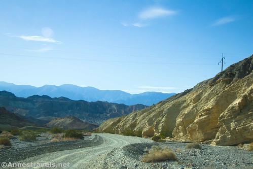
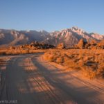
The Hole in the Wall Road begins 1.1 miles east of Zabriskie Point along CA-190 (heading away from Furnace Creek). There is usually space to park near the road entrance if you want to hike or bike the entire thing – just make sure to be out of the way of traffic. At first, the road is fairly benign. The NPS sends even low-clearance vehicles up to the first three campsites. So if you want to drive as far as possible, go for it! (Note that you do need a permit to camp on Hole in the Wall Road.)

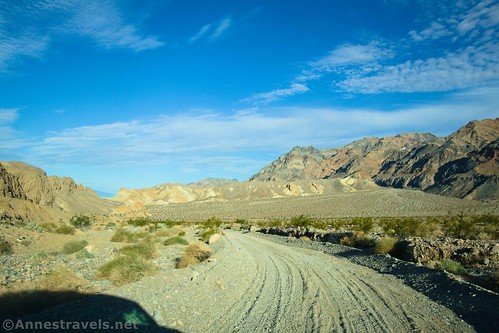
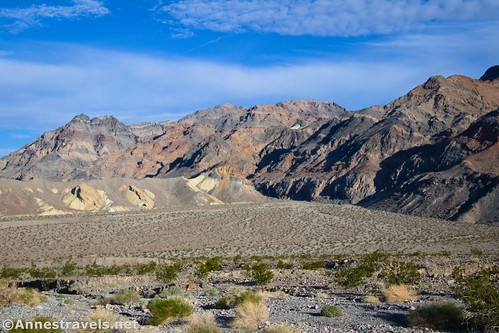
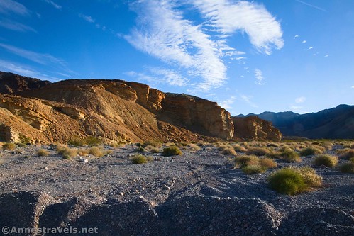
The road climbs from the first, ascending up a wash. The early portion is bordered by pebble-and-dirt walls, but eventually, these recede. Views are good up to the Funeral Mountains and especially to the Hole in the Wall.
Be sure to look back down the alluvial fan – views are spectacular!

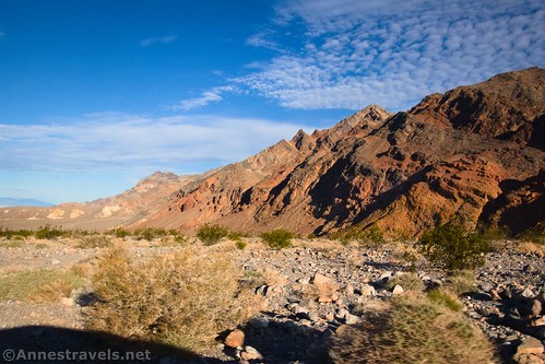
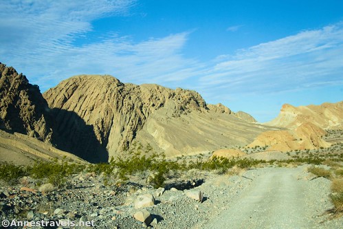
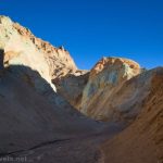
Pass by the first three campsites (usually 2WD, low-clearance accessible) and then two more (usually reserved for high clearance) before reaching Hole in the Wall at mile 3.6. It’s not hard to figure out how this formation received its name – it’s literally a hole in a wall of rock! The rocks around and within the hole are super cool.

The sixth campsite is located inside of the hole. I thought it was a great location. Some would say that, normally, the sixth site is only accessible with 4×4, though the NPS seems to think that it’s typically 2WD, high-clearance accessible.

If you don’t have 4×4, you’ll want to park just before or in the Hole in the Rock, as the road beyond this ascends a wash and can have deep gravel. Parking when I visited would have been limited to the sixth campsite; the road simply wasn’t wide enough to park along it. If the walls of gravel along the road are washed away in another flood, then parking should become easier again.

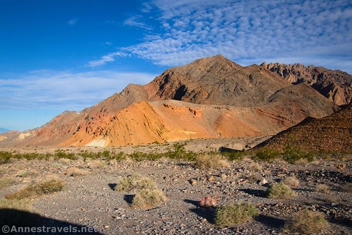
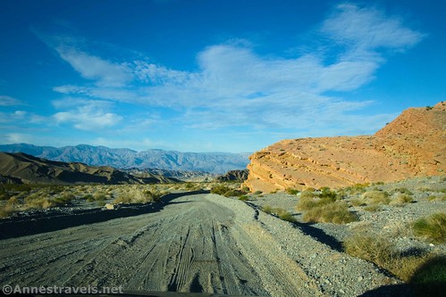
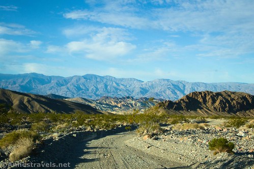
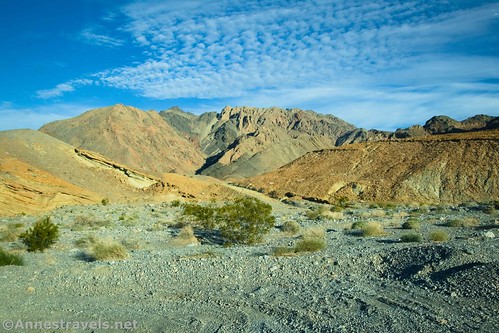
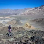
Beyond the Hole in the Wall, the road turns right to work its way up the wash. This is the most beautiful part of the road IMO. The mountains to the left have multiple colors (mostly red and brown) in unique formations.
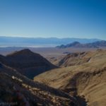
The colorful hills around 20 Mule Team are also visible, set below the Black Mountains.

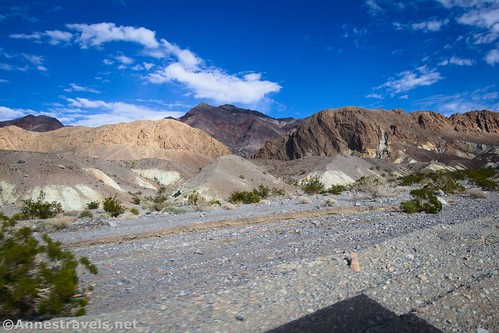
To the west, the badlands are colorful similar to Zabriskie Point. It’s just a great view pretty much anywhere you look!
The road ends in a turn-around area (small loop) 6.0 miles from CA-190. A few prospects are nearby – old topo maps say that this was a quarry, though it looks more like mining to me.
According to old topo maps, you can continue on foot a short distance east, then turn north into the Red Amphitheater and up the canyon deep into the Funeral Mountains – the old road ends about 36.459188°, -116.646497°. It appears to be a fairly wide canyon with one or two short stretches of narrows. But I didn’t take the time to check it out, so you’ll have to let me know if you do!
If you want more exploration opportunities, I drove back down to the sixth site, parked (I did have a permit for the previous night, after all), and headed out to explore Slit Canyon and Undertaker Canyon – but that’s a topic for another post!
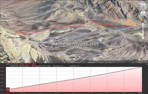
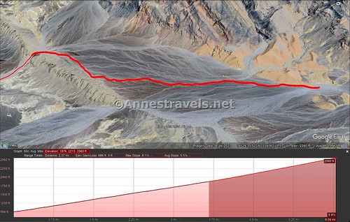
Round Trip Trail Length: 12.0 miles out & back to do the entire road (on foot, bicycle, or 4×4 vehicle); it’s 4.8 miles out & back from Hole in the Wall if you have high clearance.
Elevation Gain: 1,573ft. (992ft. to 2,562ft.) for the entire road; 686ft. for the hiking from Hole in the Wall
Facilities: Primitive campsites (permit required); no restrooms or other facilities
Fees: $30/vehicle, valid 7 days, to enter Death Valley National Park. America the Beautiful National Parks & Federal Lands Passes and Death Valley Annual Passes are accepted.
Trail Notes: Be wary of vehicles driving the road; it can be narrow in places. Technically, this is one of the few hikes in the park that allow pets (must be leashed and must stay on road). Don’t try this hike after rain, as it does experience flash floods.

Trail 
![]()
Road ![]()
![]()
![]()
Signs ![]()
![]()
![]()
Scenery
Would I go 100 miles out of my way for this? ![]()
Overall Rating: 
![]()
GPS Coordinates for the Hole in the Wall Road
Beginning on CA-190: 36.404832°, -116.782823° (36°24.28992′, -116°46.96938′ / 36°24’17.3952″, -116°46’58.1628″) (992ft.) (0.0)
Hole in the Wall: 36.413644°, -116.724262° (36°24.81864′, -116°43.45572′ / 36°24’49.1184″, -116°43’27.3432″) (1,864ft.) (3.6)
“Quarry” (mining) area (end of road): 36.407129°, -116.685890° (36°24.42774′, -116°41.15340′ / 36°24’25.6644″, -116°41’09.2040″) (2,562ft.) (6.0)
The gpx file for Hole in the Wall Road can be downloaded – please note that this and the GPS Coordinates are for reference only and should not be used as a sole resource when hiking this trail.
Download GPX File size: 97.4 KB Downloaded 310 times
(Note: I do my best to ensure that all downloads, the webpage, etc. are virus-free and accurate; however, I cannot be held responsible for any damage that might result, including but not limited to loss of data, damages to hardware, harm to users, from use of files, information, etc. from this website. Thanks!)

Getting to Hole in the Wall Road
From the Furnace Creek Visitor Center, drive east on CA-190 (toward Badwater). Pass by the Badwater Road. After 6.7 miles (0.7 miles beyond the entrance to 20 Mule Team Drive), the Hole in the Wall Road will go off on the left.
From Death Valley Junction, drive CA-190 toward Death Valley National Park. After 23.5 miles (5.3 miles west of the Dante’s View Road), the Hole in the Wall Road will go off on the right.
Today’s Featured Product!
Find the famous, the infamous, and the (almost) totally unknown in this guide to Death Valley National Park. It covers so many adventures, you won’t be able to wait to visit. Buy your copy here!


Pingback: Sneak Peak: Grand Canyon, Southern Utah, and Death Valley! – Anne's Travels