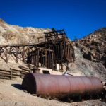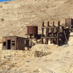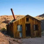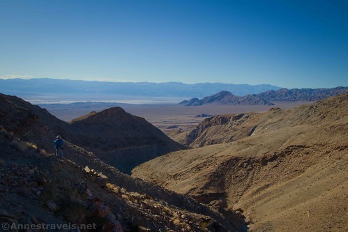
Quite a few weeks ago, I posted about visiting the Keane Wonder Spring and John Cyty’s Mill. Well, that’s a great hike. But for a truly spectacular hike, you can continue up the steep old mining trail behind the mill up toward the Big Bell Extension. The views across Death Valley are spectacular and include Corkscrew Peak and both Mt. Whitney (highest point in the contiguous US) and Badwater Flats (lowest point in North America). There are so many desert flats and mountains in view along this trail that’s breathtaking – pretty literally, since that trail is also very steep!
Quick Stats
Note: Some of the links in this post are affiliate links. If you click one and purchase something, I may earn a small commission without an extra cost to you.

The quick overview of the trail is “a steep, switchbacking hike up to a pass, then a narrow but very stable trail on the very edge of a canyon toward the Big Bell Mine”. We were running out of daylight time (having driven in from the Alabama Hills that morning), so we didn’t make it all the way to the mine (which, though it’s unmarked, is apparently private property, anyway).

To get to the Big Bell Extension Trail, you’ll need to first hike to John Cyty’s Mill (1.8 miles from the trailhead). Scramble up the hillside behind the mill. You’ll pretty quickly pick up a faint trail that heads to the left (northwest). It’s a gentle slope for a bit, then it suddenly reaches a hillside and begins switchbacking upward. From here to the saddle (about 1.25 miles and 1,500ft. of elevation gain) you’ll barely have a flat section of trail.
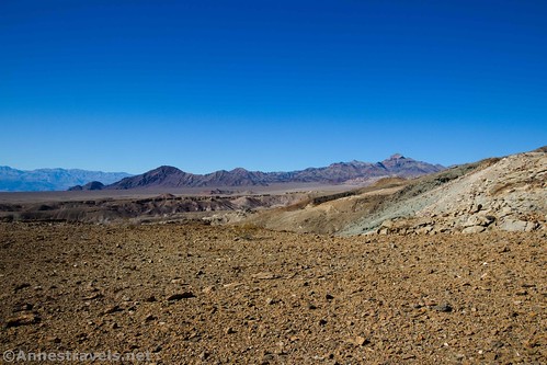
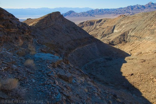
However, the trail is very solid. Despite the steep slopes and faintness of the trail, it’s firm underfoot. It’s also not difficult to follow, even though it’s not well-trod. As you rise higher, the views get better. Early on, the views are mostly over Badwater to the south. As you rise higher, you can see all the way to the High Sierras, including Mt. Whitney, and Corkscrew Peak to the northwest.
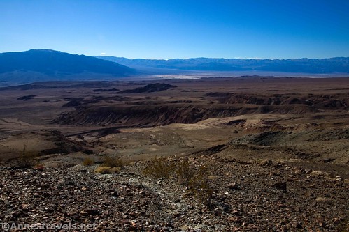
At 1.5 miles above John Cyty’s Mill, the trail finally reaches the saddle. Views are spectacular from the trail just before this. In the saddle, you also get great views down into the canyon to the north.

This is a great turn-around point for a 6.6 mile hike. You’ve seen the best scenery you’ll get on this hike. But if you love history, mines, and all that, continue across the saddle and slightly to the right to pick up the very narrow mining trail that winds along the edge of the canyon.

The trail is very narrow and slightly rough, and the further you go, the narrower and rougher it becomes. However, it’s very stable, and even when I was putting one foot directly in front of the next, I never felt like I was in danger of falling or the trail slipping down into the canyon. Still, it’s not exactly a trail for those with a fear of heights; it gave me pause and I usually don’t mind such things!
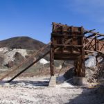
About a half a mile beyond the saddle, you’ll come to a borehole with some old beds in it (there are several beginnings of mines along the trail; this one is deeper than many). I’ve no idea why these are here or what they were used for, but we had all kinds of fun imagining renegade outlaws, miners looking for gold, and boy scouts getting patches.

We continued a short distance beyond this borehole to the ruins of a cabin or other structure that once stood on a wooden platform. While it’s perfectly possible to continue beyond this ruin, the narrow, rough trail becomes even rougher and narrower. We were running against daylight and had other hikers waiting for us back at the trailhead, so we decided we’d better just go back at this point.

If we’d chosen to continue, it’s about a tenth of a mile to a trail junction; go left a quarter mile to a mine shaft and/or right (on what looks to be a better trail) 1.5 miles up to the ruins of the Big Bell Mine. The Big Bell Extension was purchased by the Keane Wonder Mine Company as the original gold mine ran dry in hopes of continuing production. Note: I have been informed that the Big Bell Mine is private property. The owners request that park visitors please not enter their property. I don’t know if it’s signed or not, but the private property is not shown on park maps. Please respect the owners’ privacy!
Retrace your steps back to the trailhead. I truly enjoyed this hike; it’s a great way to see lots of views and some of Death Valley’s mining past without a lot of crowds and with just a touch of adventure!

Round Trip Trail Length: I went 7.1 miles total; this included walking up to the Keane Wonder Spring en route.
Elevation Gain: 2,366ft. (1,182ft. to 2,948ft.)
Facilities: None
Fees: $30/week to enter Death Valley National Park. America the Beautiful Passes and Death Valley Annual Passes are accepted.
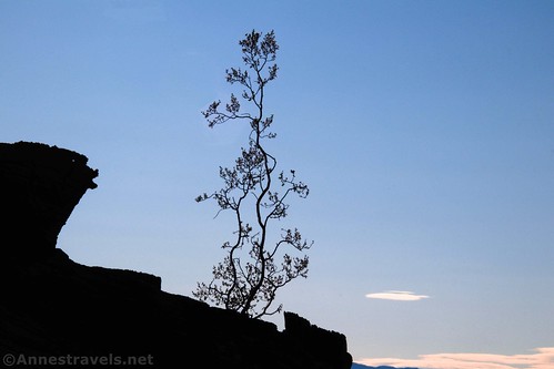
Trail Notes: The trail is quite flat to John Cyty’s Mill and not too strenuous up to the beginning of the switchbacks. After that, it’s very steep. The section beyond the saddle is vertigo-inducing if not steep. The trail is very dry and exposed, so bring plenty of water and hike it in the winter if possible. Remember to stay out of all mines and do not disturb any of the historic remains in any way!

GPS Coordinates for the Big Bell Extension
TH (for the Keane Wonder Mine): 36.6681000°, -116.9104167° (N36° 40.086′ W116° 54.625′ / 36°40’05.1600″, -116°54’37.5000″) (1,267ft.) (0.0)
John Cyty’s Cabin & Mill: 36.6761667°, -116.9268167° (N36° 40.570′ W116° 55.609′ / 36°40’34.2000″, -116°55’36.5400″) (1,252ft.) (1.85)
Saddle: 36.6893000°, -116.9180333° (N36° 41.358′ W116° 55.082′ / 36°41’21.4800″, -116°55’04.9200″) (2,708ft.) (3.33) (return 3.40 -something wrong here)
Mine with beds: 36.6902333°, -116.9130667° (N36° 41.414′ W116° 54.784′ / 36°41’24.8400″, -116°54’47.0400″) (2,851ft.) (3.83)
Cabin Ruin: 36.6904500°, -116.9124500° (N36° 41.427′ W116° 54.747′ / 36°41’25.6200″, -116°54’44.8200″) (2,896ft.) (3.87)
Whitney & Badwater view: 36.6886167°, -116.9186500° (N36° 41.317′ W116° 55.119′ / 36°41’19.0200″, -116°55’07.1400″) (2,638ft.) (4.38)
End: 36.6678000°, -116.9107333° (N36° 40.068′ W116° 54.644′ / 36°40’04.0800″, -116°54’38.6400″) (1,301ft.) (7.07)

The gpx file for the Big Bell Extension (including Keane Wonder Spring and John Cyty’s Mill) can be downloaded – please note that this and the GPS Coordinates are for reference only and should not be used as a sole resource when hiking this trail.
Download GPX File size: 129.3 KB Downloaded 428 times
(Note: I do my best to ensure that all downloads, the webpage, etc. are virus-free and accurate; however, I cannot be held responsible for any damage that might result, including but not limited to loss of data, damages to hardware, harm to users, from use of files, information, etc. from this website. Thanks!)
Getting to the Keane Spring Trailhead
From the Furnace Creek Visitor Center, turn left onto CA-190W. After 10.6 miles, turn right onto the road marked for Beatty. Drive 5.7 miles and turn right onto the well-graded dirt road to Keane Wonder. Park at the end of the road, 2.8 miles later.
The turnoff on the dirt road is 4.3 miles south of Daylight Pass Junction, where the Beatty Road meets the Daylight Pass Road at an information station with a kiosk and restrooms.
Note that the road to the Keane Spring Trailhead is gravel. While it is usually accessible to low-clearance vehicles, floods may temporarily close the road or make it high clearance only.

This Week’s Featured Product!
For more lesser-known trails in Death Valley, check out this book. It covers mountains, canyons, springs, mines, salt flats, and more!