

Many years ago, I visited the Saratoga Springs in the far south of Death Valley National Park. On my last visit, I decided to check it out again and possibly complete the hike (I actually didn’t quite make it, but I saw some interesting things along the way). The Springs themselves are worth the drive out if you happen to be in the area; from there, an old mining road rambles across the desert past several old talc mines and ruins. Most of these are part of the Saratoga Mine. You can also continue along the road to the Superior Mine Road (a branch off of the Ibex Dunes Road) and on a less-used road to the Ponga Mine.
Quick Stats

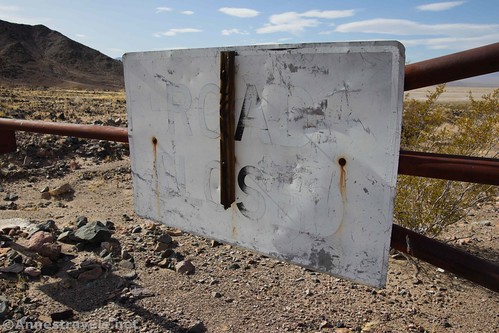
We started out very early one morning in November. You can’t do dispersed camping near the springs (or along the Saratoga Springs Road), so we had spent the night along the Ibex Dunes Road after hiking to the Ibex Dunes (a great cross-country hike in its own right). The hike to the Saratoga Springs begins at the “Road Closed” sign at the end of the Saratoga Springs Road.

The path quickly climbs up to the small ridge where you can look down on the Saratoga Springs. There are some signs that talk about the special features of the area. The bird watching can be quite good from up here. The light was a bit cloudy, but the clouds cleared as the day went on.

The Saratoga Springs were an important watering hole in this part of Death Valley. The 20 Mule Team sometimes stopped here to restock their water supply, and many early prospectors and visitors were saved from thirst by the year-round water flow. Today, do not approach the springs due to the sensitive nature of the wildlife that calls it home. Swimming is not allowed.

If you’re in this for more than a tenth of a mile out-and-back walk, turn right to follow the very obvious old mining road along the hillside. Views of the Saratoga Springs are excellent along the road; you’ll also pass the ruins of a health spa.

Continue along the old mining road to the place where it splits. This is not obvious; the more apparent of the two roads travels up the hillside. The problem with this route is that the road falls off the other side with no easy way down. You can scramble – I’ve done it – but it’s much easier to take the vaguer left fork around the end of the hillside. Either way, you’ll want to continue on the slightly vague but very followable old mining road as it heads north along the base of the hills.

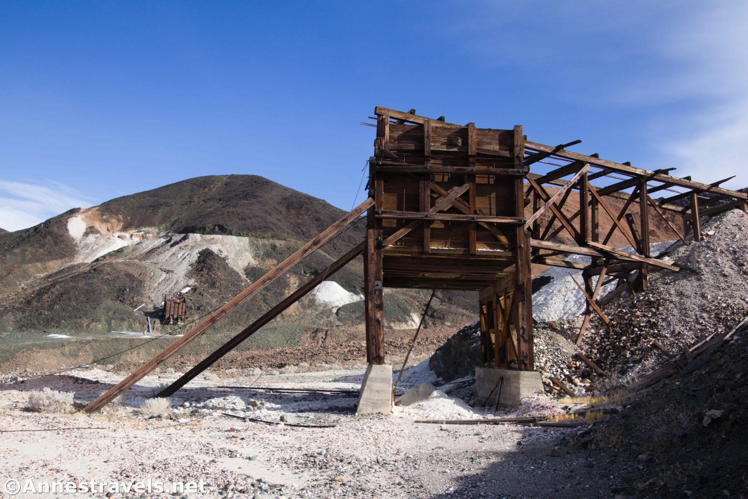
About mile 0.9, look right (east) up the valley and you’ll see an old ore chute. We turned right to scramble, off-trail, up to the chute and other ruins nearby. Be sure to check out the old stove and bedframes on a concrete slab on the way up.

There is a fair amount of junk around the old ore chute. On our first visit, we tried to stay away from the tailings, thinking that this was an old uranium mine. It was actually a talc mine, so the tailings shouldn’t be radioactive. Still, stay out of the old mines (they have the potential for being quite dangerous – talc isn’t exactly the most stable material) and respect the area. It may or may not be private property, so while no signs prohibit you from walking around the area, you should use extreme respect.

Follow the old trail to the right (south) along the hillside. You’ll pretty quickly come to the old dynamite shack – an iron door set into the hillside. It was worse for wear than the last time I saw it (c.2008), but it’s still very cool.

Retrace your steps down to the old mining road. Turn north to continue about a half a mile to more mine ruins on the right (east) up the valley. Again, we turned off-trail to scramble up to the old ore bin.

This is a much more extensive mining area than the last one. An ore bin is down below; by scrambling up to the left (north), you can climb up to a mechanism that once pulled ore out of the mine down below (remember, don’t enter the mine!) It’s a very cool area.

Both this mine and the last one were part of three claims known collectively as the Saratoga Mine. They were first worked in the 1940s and were mined off and on through the mid-1960s, producing talc. If the price of talc went up enough, it’s possible the mines would be worked again – as long as the transportation and modernization were economically worth the trouble of reopening the mines, and the mines produced more talc than in their earlier years of operation.

Across the valley is another ore bin. I wandered over there and took the twisting road up the hillside. The views from the road were fantastic.

Up at the top of the road is a large old mine shaft. As you already guessed I’m going to say, don’t go inside. The views down on the other ore bin and ore retrieval mechanism are good from up here.

We scrambled back down to the old mining road and continued north. Fairly quickly after this, the road takes a sudden sharp turn to the east. You have two options here. First, you can continue straight-ish on a vague old mining road (I didn’t see it in person – but then again, I wasn’t looking – but it shows up on topo maps and I could see it on Google imagery). This will take you (about 2 miles later) to the ruins of the Ponga Mine. Sadly, I missed this turn, so I can’t tell you what that’s like. Instead, I did option No. 2, which was to continue to follow the more obvious of the two roads eastward up to a gate. The sign on the gate says that the road is closed. Just beyond the gate, another old road in non-repair heads north and will also take you to the Ponga Mine.
We walked beyond the gate (but I left my GPS at the gate, so this part of the hike isn’t included in the coordinates, length, etc.) and up the more well-used road on the other side (better known as the Superior Mine Road). The road rises quickly up to the ruins of the Whitecap Mine. This is not terribly impressive, but it was mined for talc.

We turned around here, but if we’d continued up the Superior Mine Road, we would have come to the Superior Mine about a mile beyond the Whitecap Mine. The Superior Mine was the most developed and most profitable of the talc mines in the Ibex Hills, producing about 140,000 tons of ore.

We took the old mining road back to Saratoga Springs, enjoying the views of Death Valley from this vantage point (it’s even more beautiful when the mountains have snow on them, say in December-March), ending our hike at about 6.25 miles total without the hike up to the Whitecap Mine.

If you decide to take this hike, realize that it’s not for the faint of heart or for those unaccustomed to cross-country desert travel. There is no trail, and it’s a very remote area of Death Valley. Should something happen to you, it could easily be days or even weeks before anyone came along, and cell reception is sketchy at best. So all that to say this: Have fun, be respectful of the area and the ruins, and don’t do this alone/without previous experience! But if you are comfortable off-trail, and you love old mining stuff, it’s a great exploration that you’ll probably have to yourself!

Round Trip Trail Length: My GPS said I went 6.25 miles
Elevation Gain: 985ft. (176ft. to 483ft.)
Facilities: None
Fees: $30 to enter Death Valley National Park, valid 7 days. National Park and Recreational Lands Passes and Death Valley Annual Passes are accepted.

Trail Notes: This is a very hot, dry hike without any shade. Bring plenty of food and water. Do not disturb any of the ruins (it’s illegal) and do not enter any of the open (or closed) mine shafts. You should be well-versed in cross-country desert travel before attempting this hike as there is no official trail. 4×4 vehicles are allowed on the Superior Mine Road, but I am not aware of the condition of the road – I do know that the Ibex Dunes Road has sections of deep sand that require 4×4.

Trail 
![]()
![]()
![]()
Road ![]()
![]()
![]()
Signs ![]()
![]()
![]()
![]()
Scenery ![]()
Would I go 100 miles out of my way for this?
Overall Rating: ![]()
![]()

GPS Coordinates for the Saratoga Springs and the Saratoga Mines
Saratoga Springs Trailhead: 35.6807667°, -116.4211000° (N35° 40.846′ W116° 25.266′ / 35°40’50.7600″, -116°25’15.9600″) (381ft.) (0.0)
Saratoga Springs Overlook: 35.6811333°, -116.4217500° (N35° 40.868′ W116° 25.305′ / 35°40’52.0800″, -116°25’18.3000″) (217ft.) (250ft.)
Leave Road: 35.6913333°, -116.4232667° (N35° 41.480′ W116° 25.396′ / 35°41’28.8000″, -116°25’23.7600″) (193ft.) (0.90)

Mine 1: 35.6912167°, -116.4205167° (N35° 41.473′ W116° 25.231′ / 35°41’28.3800″, -116°25’13.8600″) (326ft.) (1.13)
Dynamite Shack: 35.6910500°, -116.4211000° (N35° 41.463′ W116° 25.266′ / 35°41’27.7800″, -116°25’15.9600″) (317ft.) (1.19)
Regain Road: 35.6917167°, -116.4233500° (N35° 41.503′ W116° 25.401′ / 35°41’30.1800″, -116°25’24.0600″) (196ft.) (1.54)
Leave Road: 35.6965667°, -116.4251000° (N35° 41.794′ W116° 25.506′ / 35°41’47.6400″, -116°25’30.3600″) (183ft.) (1.91)
Mine 2: 35.6991167°, -116.4195000° (N35° 41.947′ W116° 25.170′ / 35°41’56.8200″, -116°25’10.2000″) (316ft.) (2.31)

Mine 3 (Saratoga Mine): 35.7014833°, -116.4191667° (N35° 42.089′ W116° 25.150′ / 35°42’05.3400″, -116°25’09.0000″) (447ft.) (2.83)
Gate: 35.7057000°, -116.4208167° (N35° 42.342′ W116° 25.249′ / 35°42’20.5200″, -116°25’14.9400″) (290ft.) (4.15)
End: 35.6807667°, -116.4211333° (N35° 40.846′ W116° 25.268′ / 35°40’50.7600″, -116°25’16.0800″) (214ft.) (6.27)

The gpx file for Saratoga Springs and the Saratoga Mines can be downloaded – please note that this and the GPS Coordinates are for reference only and should not be used as a sole resource when hiking this trail.
Download GPX File size: 102.6 KB Downloaded 348 times
(Note: I do my best to ensure that all downloads, the webpage, etc. are virus-free and accurate; however, I cannot be held responsible for any damage that might result, including but not limited to loss of data, damages to hardware, harm to users, from use of files, information, etc. from this website. Thanks!)
Getting to Saratoga Springs
From CA-127 south and east of Death Valley, turn onto the dirt Saratoga Springs Road. After 5.9 miles of driving west, Saratoga Springs Road turns sharply to the right, while the Harry Wade Road (or whatever this section of road is officially called that connects the Saratoga Springs Road and the Harry Wade Road) goes straight. Keep your eyes open for this junction, as it is most natural to continue straight on the main road. Turn right toward Saratoga Springs to head due north toward the mountains. After 2.7 miles of driving north, and just before running into the mountains, the Saratoga Springs Road takes a sharp turn left to the west while the Ibex Dunes Road turns right. Continue left (west) to drive along the base of the mountains for 1.3 miles to the end of the road (the “Road Closed” sign). This is the trailhead for the Saratoga Springs.

From the Badwater Road, take the gravel Harry Wade Road south from the junction where it connects to the Badwater Road and the Jubilee Pass Road. After 25.7 miles, turn left onto the Saratoga Springs Road. After 2.7 miles of driving north, and just before running into the mountains, the Saratoga Springs Road takes a sharp turn left to the west while the Ibex Dunes Road turns right. Continue left (west) to drive along the base of the mountains for 1.3 miles to the end of the road (the “Road Closed” sign). This is the trailhead for the Saratoga Springs.

Note: When the Amargosa River is flowing, the road along the base of the mountains is 4×4 only or impassible; you’ll need to park near the Ibex Dunes Road junction (I have a story about that…) Ask about current conditions at the Death Valley Visitor Center.

This Week’s Featured Product!
For even more places to explore in Death Valley, check out this book. It includes several hikes in the southern part of Death Valley, which was more recently added to the park.
One response to “Saratoga Springs & the Saratoga Mine Road”
[…] whole reason we were down there was to hike the old mining road by Saratoga Springs the next […]