

On my first visit to Saratoga Springs in southern Death Valley National Park back in 2008, we saw the Ibex Dunes marked on a map, down a road not so very far away from Saratoga Springs. But after we got stuck in the overflow of the Amargosa River on our way back from visiting the springs, we decided the thought of the road with “deep sand” to the dunes was just too much excitement for one trip. It turns out the road to (or as close as you can get to) the dunes isn’t all that bad if you have high clearance (medium clearance might make it ok) and the dunes themselves are spectacular in the early morning or late afternoon/evening. And there is no deep sand between the road split and the route to the dunes!
Quick Stats

On our second trip to Saratoga Springs (more on that in another post), we happened to have a few extra hours before sunset. So three of us set out across the desert to see the Ibex Dunes, leaving the rest of the group to enjoy a restful evening reading and cooking supper.

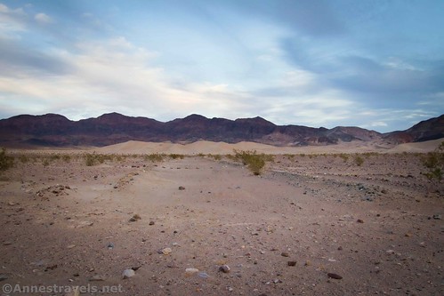
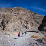
There is an old mining road that will take you close to the Ibex Dunes. It’s marked with a sign that says it’s closed to vehicles; foot and horse traffic only. The odd thing is that where the sign is you can’t tell there used to be a road. The area was ravaged by floods from the nearby wash, so all you can see is the wash beyond the sign. But if you continue across the wide wash (about 0.3 miles wide!), you can pick up the road. It makes for easy and straight walking for 0.9 miles, which is nicer than just walking across the rocky desert, dodging mesquite bushes.

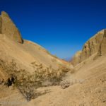
The views from the old road are nice. The light that afternoon was very strange, a mix of angled evening light and clouds. But it made for fantastic photos of the desert, the mountains, and the dunes at a distance.

After about a mile, the road was beginning to turn to the right to skirt the southern end of the dune field. So we turned left, off of the road, and headed in as straight a line as possible for the Ibex Dunes.

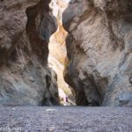
We could see footprints from one or two other groups who had visited the dunes recently. But other than that, the Ibex Dunes were deserted and so very, very quiet. You could stand there on the edge of the dunes and hear nothing except the whisper of the wind in the grease bushes and maybe a bird trilling somewhere. It’s a feeling of being very, very alone in a wonderful and beautiful place of stillness.

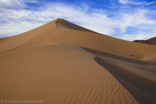
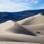
At the edge of the dune field, we paused to plot our course. We knew we wanted to climb the tallest dune as long as it wasn’t impossible. On the other hand, we’ve also hiked enough sand dunes to know that the most direct route up is probably also the most difficult. So we figured a course that would take us up ridgelines and finally to the top of the highest point of the Ibex Dunes.

Climbing up, we could have been the first people to have explored the sand dunes. Footprints are quickly erased by the ever-present wind that sculpts the dunes into new shapes with every hour yet unnoticeable for days or months or years.

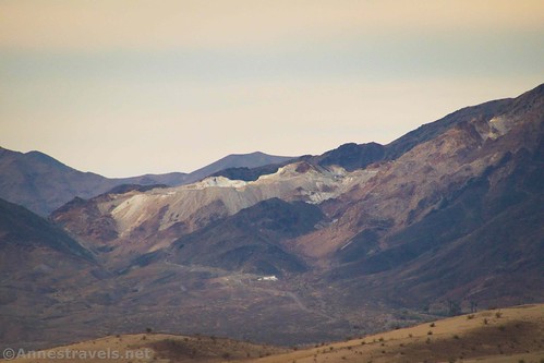
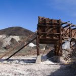
Over to the south, we could see an ore hopper and possibly some other ruins from talc mining operations in the area before it became part of the national park. I’d have loved to get closer to the ruins, but daylight was running out (as it was, we barely made it back before dark). Within the dunes, there were little sheltered bowls with desert plants.

Climbing up the final ridgeline to the top was possibly the most fun. The views are fantastic of the area, and the views of the dunes are so classic that they blew my mind. The pictures I took here are some of my favorites from the entire trip!

We got to the top and briefly considered jumping down the steep western face. But it seemed too steep, and we were wearing shoes (jumping down sand dunes is more fun in bare feet because you don’t have to worry about your shoes getting full of sand). So we retraced our steps back down the ridgelines, running and jumping and having all the fun that sand dunes offer adults who don’t mind pretending they’re little kids again.

From the base of the dunes, we angled back toward the old mining road and from there back to where we’d left our van.

We made it back to the van shortly before dark, in time to finish up supper and eat by lantern-light (how long has it been since we fired up the Coleman lantern to eat?) Overall, the Ibex Dunes were a highlight of the trip for those of us who hiked it. I highly recommend you take a stab at it if you don’t mind some cross-country travel and try it when it’s not too hot to be enjoyable.

Total Length: 3.1 miles (your mileage may vary due to using a different route than the one I took)
Elevation Gain: 327ft. (259ft. to 499ft.)
Facilities: None, not even an official parking area
Fees: $30/vehicle, valid 7 days. America the Beautiful National Park Passes and Death Valley Annual Passes accepted.
Trail Notes: Don’t try this when it’s hot outside – the area is very exposed. Also, don’t hike up the dunes during a thunderstorm (you don’t want to be the highest thing around!) You will need high clearance to get down the Ibex Springs Road to the trailhead, but another option is to park somewhere along the Saratoga Springs Road and walk to the trailhead. That adds 1.8 miles to the overall hike. The views here will be best in the early morning or late afternoon/evening, when the shadows and light are best on the dunes.

Trail 
![]()
![]()
![]()
Road ![]()
![]()
![]()
Signs ![]()
![]()
![]()
Scenery
Would I go 100 miles out of my way for this?
Overall Rating: ![]()
![]()
GPS Coordinates for Ibex Dunes
Sign marking Old Mining Road: 35.6949667°, -116.3932000° (N35° 41.698′ W116° 23.592′ / 35°41’41.8800″, -116°23’35.5200″) (237ft.) (0.0)
Ibex Dunes: 35.6985667°, -116.3716667° (N35° 41.914′ W116° 22.300′ / 35°41’54.8400″, -116°22’18.0000″) (342ft.) (1.35)
Top of big dune: 35.7003000°, -116.3712833° (N35° 42.018′ W116° 22.277′ / 35°42’01.0800″, -116°22’16.6200″) (506ft.) (1.6)
Road on the other side of wash: 35.6963333°, -116.3888500° (N35° 41.780′ W116° 23.331′ / 35°41’46.8000″, -116°23’19.8600″) (275ft.) (2.86)
End: 35.6949500°, -116.3931833° (N35° 41.697′ W116° 23.591′ / 35°41’41.8200″, -116°23’35.4600″) (254ft.) (3.13)
Download GPX File size: 38.6 KB Downloaded 445 times
(Note: I do my best to ensure that all downloads, the webpage, etc. are virus-free and accurate; however, I cannot be held responsible for any damage that might result, including but not limited to loss of data, damages to hardware, harm to users, from use of files, information, etc. from this website. Thanks!)

Getting to Ibex Dunes Trailhead
From CA-127 south and east of Death Valley, turn onto the dirt Saratoga Springs Road. After 5.9 miles of driving west, Saratoga Springs Road turns sharply to the right, while the Harry Wade Road (or whatever this section of road is officially called that connects the Saratoga Springs Road and the Harry Wade Road) goes straight. Keep your eyes open for this junction, as it is most natural to continue straight on the main road. Turn right toward Saratoga Springs to head due north toward the mountains. After 2.7 miles of driving north, and just before running into the mountains, the Saratoga Springs Road takes a sharp turn left to the west. Instead of turning left with the main road, turn right onto the Ibex Road, marked by a sign telling you that there is deep sand a certain distance ahead (I believe it’s 4 miles ahead, but I could be wrong). Drive 0.9 miles on the rough but firm and humped road to the sign marking the old mining road. Park along the road (out of the way, of course!) This route is 2WD, low-clearance friendly until turning onto the Ibex Road, when high clearance is required due to the hump in the middle of the road.
From the Badwater Road, take the gravel Harry Wade Road south from the junction where it connects to the Badwater Road and the Jubilee Pass Road. After 25.7 miles, turn left onto the Saratoga Springs Road. After 2.7 miles of driving north, and just before running into the mountains, the Saratoga Springs Road takes a sharp turn left to the west. Instead of turning left with the main road, turn right onto the Ibex Road, marked by a sign telling you that there is deep sand a certain distance ahead (I believe it’s 4 miles ahead, but I could be wrong). Drive 0.9 miles on the rough but firm and humped road to the sign marking the old mining road. Park along the road (out of the way, of course!) This route is 2WD, high-clearance friendly part of the year; when the Amargosa River is flowing, the route is 4×4 only or impassible. Ask about current conditions at the Death Valley Visitor Center.

This Week’s Featured Product!
Looking for more interesting places in Death Valley? The author of this guide offers routes to see much of what the park has to offer.
One response to “A Beautiful Evening at the Ibex Dunes!”
[…] drove down to the far southern part of Death Valley and got there in time to take the non-trail to Ibex Dunes before […]