

There’s a nice little scenic drive a short distance up CA-190 from Furnace Creek. It’s called 20 Mule Team because it’s the route that the famous “20 Mule Team” used to transport borax out of Death Valley. But I have a definite weakness when it comes to the 20 Mule Team Scenic Drive: I can’t stay in the van. Even the first time we visited, back in 2001, I had to get out and explore the gullies and badlands along the drive.
Quick Stats
(Affiliate links are present on this page.)

The scenic drive is best in the early morning or about an hour or so before sunset. (They do close the scenic drive at night, so be wary of leaving the area before they close the gates. You wouldn’t want to be lost among the badlands after dark, anyway, so I recommend morning over evening.) The good thing about the sun being low in the sky is that the shadows create definition between the hills, making it much more scenic than at high noon.

If you’re a Star Wars fan, be sure to keep your eyes peeled for various shooting areas around 20 Mule Team. Several scenes from Star Wars Episode VI: Return of the Jedi were filmed here, including Jabba the Hutt’s palace and a cave where Luke Skywalker finishes his light saber. (Note that the cave is now closed for safety reasons.) There may be other film sites in the area, as well; I haven’t spent much time looking for film sites there.

One of the most difficult parts of exploring the badlands of 20 Mule Team is finding a safe place to park. Never, ever block the road – other people want to drive it, too. Since it’s narrow and only one-way, you’ll have to find a wash or someplace you can safely pull off without trampling vegetation, etc.
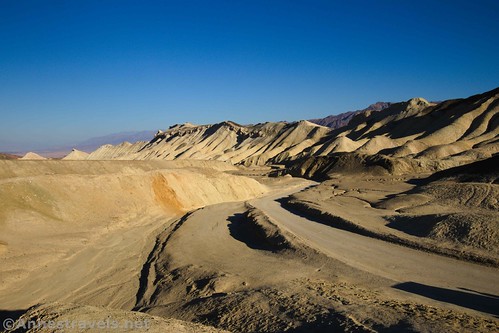
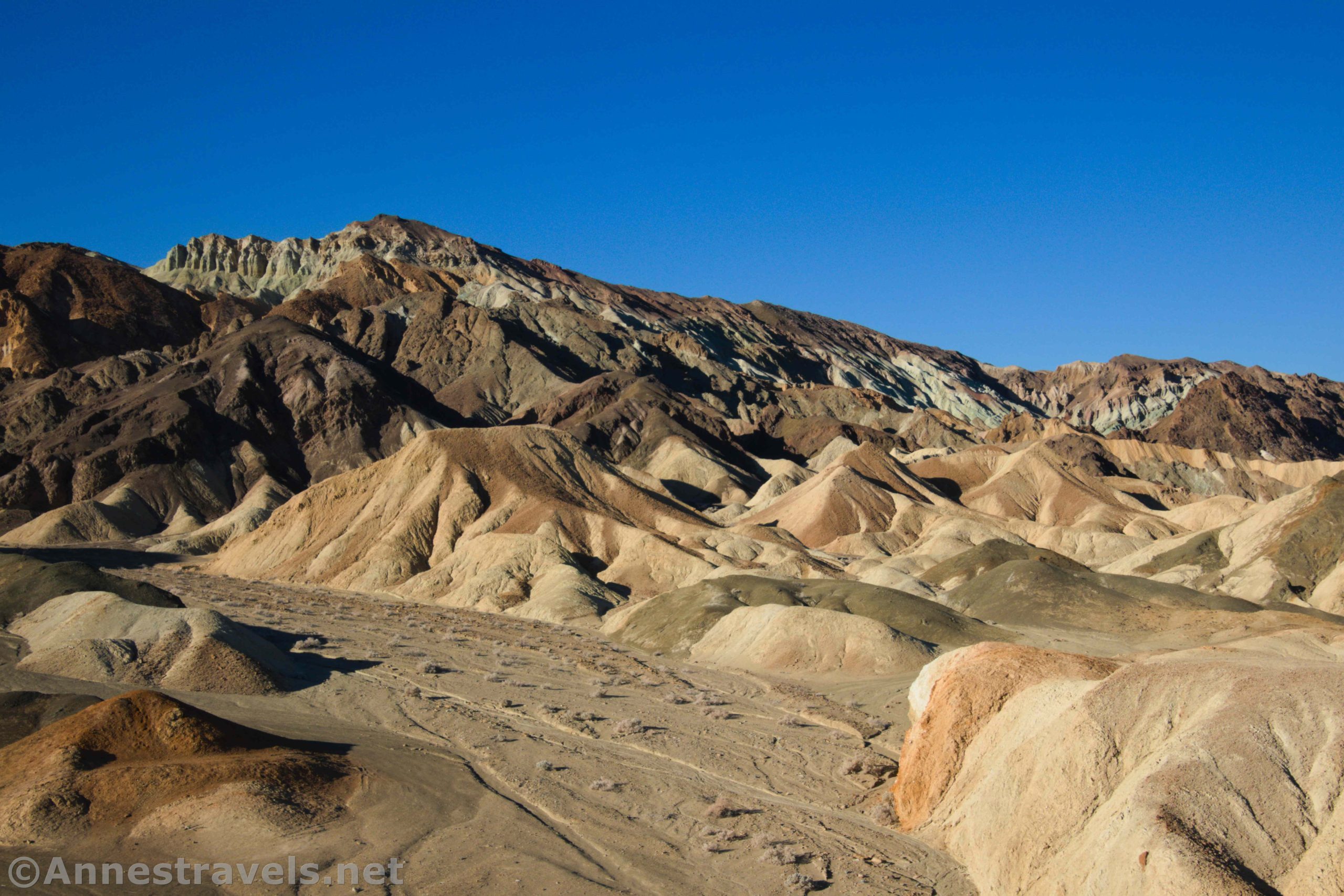
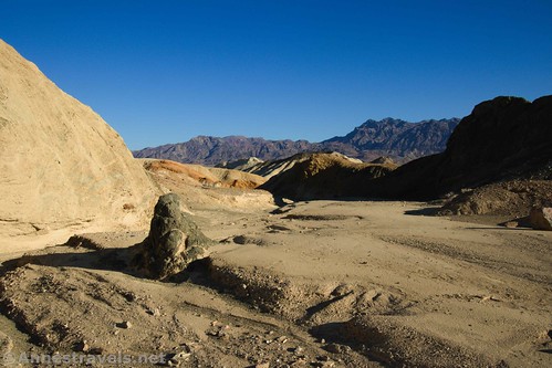
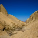
On our most recent visit, I started up the wash that was called 20 Mule Team Canyon on my GPS. (More on 20 Mule Team Canyon later.) It was very early morning, and the shadows were deep amongst the badlands.

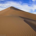
Pretty quickly, I followed a social trail up a ridgeline to the top of a badland hill (about mile 0.5) on the right (west) side of the wash. The views were great, especially to some colorful rocks high in a canyon to the right/west.

Some of my other group members were also exploring. Our general rule at this point is that if we’re exploring alone, then we must keep tabs on each other. I broke that rule later (yikes!), but for the moment we waved to each other from different badland hills.
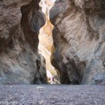
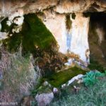
Underneath the hill, I found an old borax mine (there are many old mines in 20 Mule Team). The National Park Service has put in pipes to make the entrances more stable and bars to keep people out of them – these mines are not safe. Never go inside a mine, unless it is specifically labeled as safe to enter.

I weighed the choices: Go up 20 Mule Team Canyon, or take a social trail up the hills on the other side of the wash? I finally decided on the social trail and started up.

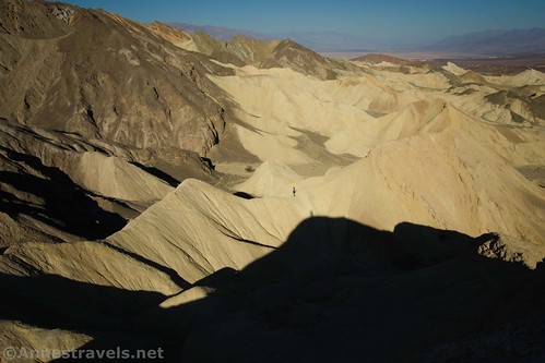
It was not as easy as it looked. The first part was fairly stable, but eventually I found myself on loose rocks on a steep hillside. And it was steep! I thought about giving up, but pressed on. The views were great when I found a place stable enough to stop and rest.

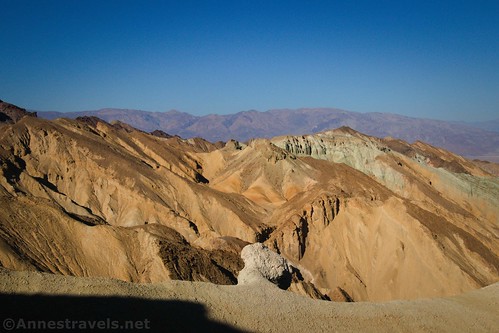
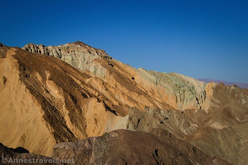
After what felt like at least 20 minutes of climbing, I came suddenly to a pile of rocks that looks like some kind of rocky wind block/lookout about mile 1.25. The views are fantastic up here. Not only can you look down on 20 Mule Team, but you can also look over to the west and see colorful badlands and to the north and see the dry, rugged mountains. Beautiful!

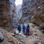
I could see one of my group members on top of one of the taller badland hills, so I took a picture of him.

From here, I had another choice: Did I want to scramble back down, scramble higher on the hillside (not an appealing thought!), or go down another way? I decided, for better or worse, to go south, around the rib of the hill, and to descend via an unstable badland wash. It turned out to be a reasonable way down, and certainly easier than the loose scree I’d scrambled on the way up.
But that took me down in 20 Mule Team Canyon… which is worth a post unto itself, so I won’t detail that here. Be on the lookout for it in early 2021!
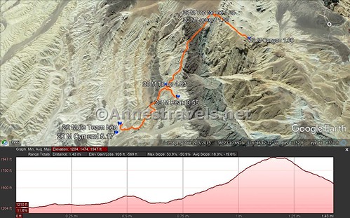
Round Trip Trail Distance: Varies; 1 mile RT will get you some nice scenery up at the top of the first badland peak I climbed. I was at 1.25 miles up at the wind block.
Elevation Gain: Varies; going up one peak, up to the wind block, and down to the wash again was 928ft. elevation gain
Facilities: None; restrooms are available at Zabriskie Point
Fees: $30/7 days; Death Valley Annual and National Park & Federal Recreational Lands Passes accepted.
Trail Notes: Do not attempt to explore this area during the warm summer months – it’s not worth risking heatstroke and dehydration. Since there is no trail, it’s just you and your sense of direction (much better to have a map and compass on you). If you get lost, head north – you’ll run into either the 20 Mule Team Scenic Drive or CA-190 sooner or later, and you can follow the road back to your vehicle. Don’t attempt this hike if you’re prone to getting lost.

Trail 
![]()
![]()
![]()
![]()
Road ![]()
Signs ![]()
![]()
![]()
Scenery ![]()
Would I go 100 miles out of my way for this? ![]()
Overall Rating: ![]()
![]()

GPS Coordinates for 20 Mule Team
Beginning (western end) of the 20 Mule Team Scenic Drive: 36.409644, -116.794734 (36°24.57864′, -116°47.68404’ / 36°24’34.7184″, -116°47’41.0424″)
End (eastern end) of the 20 Mule Team Scenic Drive: 36.397922, -116.770275 (36°23.87532′, -116°46.21650′ / 36°23’52.5192″, -116°46’12.9900″)
Beginning: 36.3911000°, -116.7782000° (N36° 23.466′ W116° 46.692′ / 36°23’27.9600″, -116°46’41.5200″) (1,202ft.) (0.0)
Peak in 20 Mule Team: 36.3878833°, -116.7802833° (N36° 23.273′ W116° 46.817′ / 36°23’16.3800″, -116°46’49.0200″) (1,403ft.) (0.55)
Lookout: 36.3822833°, -116.7781667° (N36° 22.937′ W116° 46.690′ / 36°22’56.2200″, -116°46’41.4000″) (1,852ft.) (1.22)
As high as I went: 36.3816833°, -116.7779667° (N36° 22.901′ W116° 46.678′ / 36°22’54.0600″, -116°46’40.6800″) (1,930ft.) (1.28)
The gpx file for my trek around 20 Mule Team can be downloaded – please note that this and the GPS Coordinates are for reference only and should not be used as a sole resource when hiking this trail.
Download GPX File size: 61.8 KB Downloaded 439 times
(Note: I do my best to ensure that all downloads, the webpage, etc. are virus-free and accurate; however, I cannot be held responsible for any damage that might result, including but not limited to loss of data, damages to hardware, harm to users, from use of files, information, etc. from this website. Thanks!)
Getting to 20 Mule Team
From the Furnace Creek Visitor Center, turn right onto CA-190. Pass by the road to Badwater after 1.3 miles; continue another 4.7 miles (you’ll also pass Zabriskie Point). Turn right onto the 20 mule team for 1.8 miles to the mouth of 20 Mule Team Canyon or wherever you can safely find a place to pull off. Note that the canyon isn’t signed and Google has it in the wrong place, so you’ll be best off using the GPS coordinates above.
The entrance to the 20 Mule Team Scenic Drive is 0.7 miles west of the Echo Canyon road and 6.1 miles west of the road to Dante’s View.
The 20 Mule Team Scenic Drive is dirt/gravel, but it’s usually accessible to passenger cars. Don’t attempt after a heavy rain.
This Week’s Featured Product!
For family hikes and easy strolls (but with a bit of adventure thrown in), check out this guide to day hiking Death Valley National Park. Maps and trail advice help you to discover the best of the easy hikes the park has to offer.
2 responses to “Exploring 20 Mule Team”
[…] few weeks ago, I talked about exploring around 20 Mule Team Scenic Drive in Death Valley National Park. Well, partially by accident, and partially intentionally, I […]
[…] Back in Death Valley, we spent a very happy morning exploring around the 20 Mule Team Road. I trekked up a hillside or two… […]