

A family favorite from our trip to Death Valley last fall was Sidewinder Canyon. There’s something just so fun about exploring multiple slot canyons and discovering arches, caves, rock formations, and so much more. Plus we got some great views of Badwater Flats. Granted, we probably explored more than most people would, but that made it all the more fun!
Quick Stats

There are technically three slot canyons off of the main Sidewinder Canyon. However, if you actually explore all of the side canyons, there are a total of six slot canyons (or more, depending on how you want to count). I ended up exploring four of the six canyons plus I hiked all the way up to the end of the main Sidewinder Canyon. That took me all day. I’d have loved to have also explored Side Canyon 6 (which, along with Side Canyons 4a and 5, is one of the more exciting slots). But daylight fades quickly in November, and given that it rained later, I was just as glad not to be in a canyon too late!

We started out early in the morning, climbing up the trail that ascends the alluvial fan outside of Sidewinder Canyon. The trailhead is actually for both Willow Canyon and Sidewinder Canyon, with the former trail striking north and the later trail (the one we want for this post) striking south. I had hiked Willow Canyon earlier in the trip, and while I’m sure it’s a nice enough canyon, it simply doesn’t compare to Sidewinder Canyon (especially when Willow doesn’t have any water in the waterfall, but I digress). So if you only have time for one of the two canyons, I highly recommend Sidewinder over Willow. In fact, even if you have time, I recommend Sidewinder over Willow.

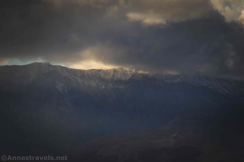
The trail up the alluvial fan is steep but not too bad. It’s also very exposed. But looking back, the views down on Badwater Flats are incredible. The day I was hiking, Telescope Peak had its (I believe) first major snowfall for the year. So we played peek-a-boo with the peaks most of the day, but it was still beautiful.
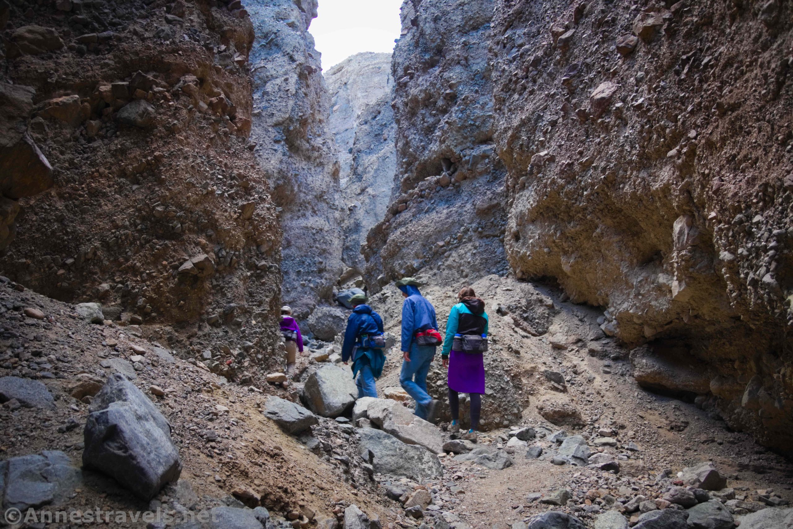
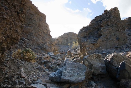
At the top of the alluvial fan, the trail turns left (east) into Sidewinder Canyon. The walls rise up, and while the trail more or less disappears, there’s only one direction to go: up the canyon!

You’ll pass Slot 1 (the only slot on the left (north); sometimes called Slot -2) at about mile 0.6. I did not explore the first slot simply because I didn’t see that it existed! I hear that it’s not very exciting, but you can walk up it for about 0.2 miles if desired.

Slot 2 (sometimes called Slot-1) is about 0.05 miles up Sidewinder Canyon on the right (south) side. This was the first slot that I explored. It’s not very exciting, but you can walk up the slot for about 0.15 miles.
Slot 3 (sometimes called Slot 0) is about a tenth of a mile up Sidewinder Canyon from Slot 2, and, similarly, it is about 0.15 miles long into the south canyon wall. We scrambled (Class 3) up beyond the dryfalls at the end and had a nice view over Badwater Flats and Sidewinder Canyon. Otherwise, it’s not terribly exciting.

Slot 4 (often called Slot 1) is the first of the exciting slot canyons, located about 0.05 miles upcanyon from Slot 3. There are actually two forks to Slot 4, which I’ll call Slot 4a and Slot 4b. Walk up Slot 4 for a hundred feet or so, and then the canyon splits. Honestly, Slot 4b (to the right (west)) isn’t worth scrambling up. You could probably do it in about 5 minutes, and except for a passable view and an interesting dryfall, that’s it.

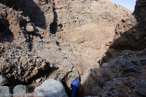
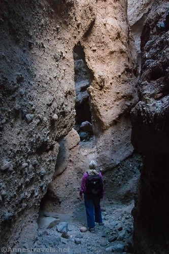
Slot 4a, on the other hand, is well worth checking out. At the split in Slot 4, turn left toward what looks like a massive, impassable choke stone. Some of my group tried climbing up the rocks, but the easiest route into the slot is by crawling (ducking, really) under the rocks on the left (east) side of the pile of rocks.

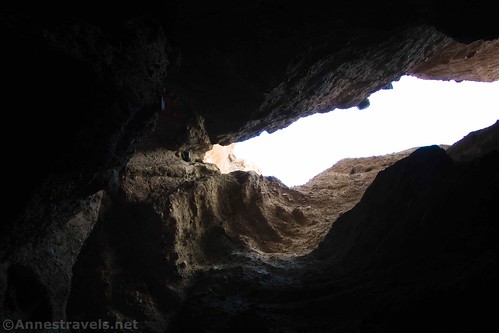
Slot 4a is very narrow, and the walls mostly close in overhead, creating a dark passageway. I almost wished I had a flashlight with me – but it’s pretty fun to do it in the dark. On my way back down, I found one of my group members using her phone flashlight. So there’s always that! The canyon becomes narrower and darker as it winds into the hillside for about 0.4 miles to end in a very dark grotto. So cool!

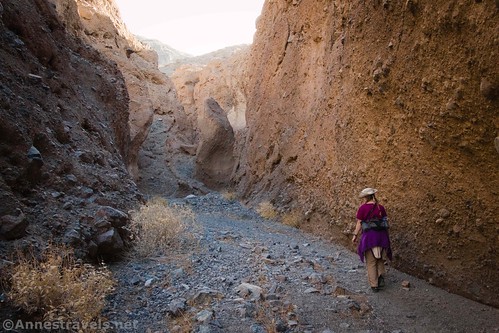
Slot 5 (often called Slot 2) is about a tenth of a mile up the main Sidewinder Canyon from Slot 4. It’s the second of the exciting slots, and it’s the one we explored most completely. Even the entrance looks exciting:
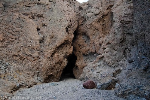
The first 0.15 miles are fairly easy without too many scrambles up dryfalls (there’s one that’s probably mild Class 3). At that point, there is a very cool arch in the slot canyon!
Nearby is the first of the difficult dryfalls. There is at least one if not two more dryfalls (difficult but not impossible to scramble; maybe about Class 3 with an occasional Class 4 move – all of us made it except for one member of my group who doesn’t like scrambling or heights or tight spaces). The canyon winds through the hill in narrow glory for about 0.4 miles total.

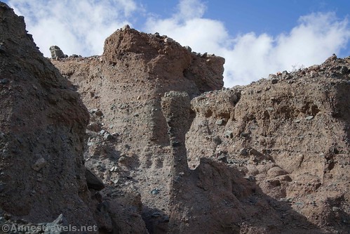
Beyond the 0.4 mark comes a challenge, but it’s rewarding if you have the time, energy, and know-how. A Class 3+ slope/dryfall offers a chance to exit the canyon and scramble up on top of the hillside. Be sure to look to the west (right) as you scramble – there are some very interesting rock formations.
Once on top of the hillside, a social trail leads left (east) up to a high point. Actually, a trail traverses the ridgeline, which is interesting. I’d have liked to have known where it went, but we didn’t have time to check it out. Instead, we walked up to the high point and took in the fantastic views of Death Valley, Badwater Flats, Sidewinder Canyon, the Black Mountains (which Sidewinder Canyon cuts into), and the Panamint Mountains (including Telescope Peak, the highest point in the park). This view is beautiful!

Back down in Sidewinder Canyon, the day was moving on. What we should have done was to sit down and eat lunch but, as you know we’d do, we decided to just keep eating snacks and continue up into the narrows of Sidewinder Canyon (to quote one of my group members, if you pack 20 snacks for a hike, you might as well eat 10 of them). The Narrows are quite visible from near Slot 5. They’re probably eight feet wide, but that’s a lot narrower than down near the mouth of Sidewinder Canyon.

About 0.3 miles beyond the mouth of Slot 5 is the mouth of Slot 6, on the right (south) side of the canyon like most of the other slots in Sidewinder Canyon. I hesitated, then walked past it. We simply didn’t have time to explore Slot 6 (often called Slot 3). I regret that; I’ve seen photos online of an arch or two, lots of narrows, and fun dryfalls to scramble. It’s also about 0.5 miles long (maybe longer, depending on how much you like scrambling), and we definitely didn’t have time for that and to get all the way up to the top of Sidewinder Canyon.
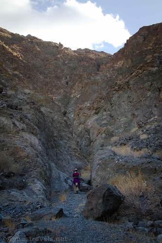
Few people venture beyond Slot 6 up Sidewinder Canyon, which means the upper canyon has a wilder feel to it. The walls stay about 8ft. wide in most places, but the views are great and there are a few small, smooth dryfalls to scramble (Class 2/Class 3) – but most of them are firm footing, unlike the dryfalls in the slots. Shortly before the end of Sidewinder Canyon, the walls narrow briefly – which is both pretty and fun.
Sidewinder Canyon doesn’t end in a sheer wall; it’s more like a giant tumble of rocks 3.2 miles from the parking area (not including any slots). You could scramble up them, but daylight was fading quickly. There’s also a slot canyon on the left (east), but I know very little about it.

We retraced our steps back down Sidewinder Canyon and made it back to the parking area just as the first rain in months sprinkled down on Death Valley. The setting sun and the incoming storm made for some pretty interesting pictures. I’d totally do Sidewinder Canyon again if I was in the area… but preferably on a day when it wasn’t supposed to rain!

Round Trip Trail Length: 6.4-9.1 miles (depending on how many spurs you take)
Elevation Gain: 1,624ft. (-234ft. to 1,113ft.)
Facilities: None
Fees: $30/vehicle, valid 7 days. America the Beautiful National Parks & Federal Lands Passes and Death Valley Annual Passes also accepted.

Trail Notes: Do not try this hike 1) in the heat of summer (May-September), or 2) when rain is predicted – you don’t want to be in the canyon if a flash flood comes along! Several of the slots require scrambling up dryfalls; don’t attempt them unless you’re used to scrambling Class 3 slopes on unstable terrain. The slots are often narrow (down to a couple of feet wide), but even my group member who hates tight spaces made it all right. Note that the elevation gain may be skewed since both my GPS and GoogleEarth tend to get confused in tight spaces like slot canyons. Also note that neither the distance nor the elevation gain takes into consideration climbing to the top of the hill above Slot 5.

Trail 
![]()
![]()
![]()
Road ![]()
Signs ![]()
![]()
![]()
Scenery
Would I go 100 miles out of my way for this?
Overall Rating: 
![]()

GPS Coordinates for Sidewinder Canyon
Sidewinder Trailhead: 36.0648667°, -116.7449667° (N36° 03.892′ W116° 44.698′ / 36°03’53.5200″, -116°44’41.8800″) (-127ft.) (0.0)
Slot 1 (actually Slot 2): 36.0564833°, -116.7436000° (N36° 03.389′ W116° 44.616′ / 36°03’23.3400″, -116°44’36.9600″) (111ft.) (0.71)
End of Slot 1 (actually Slot 2): 36.0554167°, -116.7447000° (N36° 03.325′ W116° 44.682′ / 36°03’19.5000″, -116°44’40.9200″) (252ft.) (1.07)
Slot 2 (actually Slot 3): 36.0552833°, -116.7424500° (N36° 03.317′ W116° 44.547′ / 36°03’19.0200″, -116°44’32.8200″) (179ft.) (1.46)
Top of Slot 2 (actually Slot 3): 36.0539000°, -116.7426333° (N36° 03.234′ W116° 44.558′ / 36°03’14.0400″, -116°44’33.4800″) (353ft.) (1.67)
Slot 3 (actually Slot 4): 36.0537167°, -116.7406667° (N36° 03.223′ W116° 44.440′ / 36°03’13.3800″, -116°44’26.4000″) (272ft.) (2.15)

Slot 3 Split (actually Slot 4): 36.0531167°, -116.7407833° (N36° 03.187′ W116° 44.447′ / 36°03’11.2200″, -116°44’26.8200″) (301ft.) (2.34)
Slot 3 Right Top (actually Slot 4b):36.0521667°, -116.7419833° (N36° 03.130′ W116° 44.519′ / 36°03’07.8000″, -116°44’31.1400″) (435ft.) (2.59)
Slot 4 (actually Slot 5): 36.0529500°, -116.7390833° (N36° 03.177′ W116° 44.345′ / 36°03’10.6200″, -116°44’20.7000″) (344ft.) (3.06)

Ridge (top of hill): 36.0473000°, -116.7377167° (N36° 02.838′ W116° 44.263′ / 36°02’50.2800″, -116°44’15.7800″) (991ft.) (3.93)
Entrance (begin the narrows of Sidewinder Canyon): 36.0529333°, -116.7386333° (N36° 03.176′ W116° 44.318′ / 36°03’10.5600″, -116°44’19.0800″) (331ft.) (5.11)
Enter Slot (in the Sidewinder Narrows): 36.0467000°, -116.7253833° (N36° 02.802′ W116° 43.523′ / 36°02’48.1200″, -116°43’31.3800″) (928ft.) (6.36)
Top (as in, the end of the main Sidewinder Canyon): 36.0449833°, -116.7248667° (N36° 02.699′ W116° 43.492′ / 36°02’41.9400″, -116°43’29.5200″) (1,102ft.) (6.62)
Slot 5 (actually Slot 6 on my way back downcanyon): 36.0516500°, -116.7348500° (N36° 03.099′ W116° 44.091′ / 36°03’05.9400″, -116°44’05.4600″) (415ft.) (7.75)
End: 36.0650500°, -116.7450000° (N36° 03.903′ W116° 44.700′ / 36°03’54.1800″, -116°44’42.0000″) (-243ft.) (9.11)

The gpx file for Sidewinder Canyon can be downloaded – please note that this and the GPS Coordinates are for reference only and should not be used as a sole resource when hiking this trail. Also note that this GPS file includes all six slot canyons plus the trek up to the top of the main Sidewinder Canyon but not the scramble up to the top of the hill.
Download GPX File size: 131.1 KB Downloaded 462 times
(Note: I do my best to ensure that all downloads, the webpage, etc. are virus-free and accurate; however, I cannot be held responsible for any damage that might result, including but not limited to loss of data, damages to hardware, harm to users, from use of files, information, etc. from this website. Thanks!)

Getting to Sidewinder Canyon Trailhead
From Furnace Creek, drive south on CA-190E. After a mile, turn right on the Badwater Road. Pass by many of the famous destinations of Death Valley, including Golden Canyon, Artist Pallet, and Badwater Basin. After 31.3 miles, a sign will indicate the Sidewinder Trailhead on the left (east).

From CA-127 north of Shoshone, turn onto the Jubilee Pass Road. Drive 24.9 miles, then take the paved road as it turns sharply north at the junction for the Harry Wade Road for another 14.5 miles to the Sidewinder Trailhead, on the right (east).

The parking area is gravel, but it should be passable by low-clearance vehicles under most circumstances.

This Week’s Featured Product!
With 57 day hikes and backpacking trips in Death Valley National Park, this book is a great resource for planning your trip to the area. It includes maps, photos, GPS coordinates, and more for a great time exploring Death Valley.