I wouldn’t call Willow Canyon the most spectacular hike in Death Valley. It’s nice, and in many places, it would be awesome and amazing. But Death Valley has so much to offer – even from the same parking area – that Willow Canyon just doesn’t live up to the hype. Of course, if you’re hiking early in the season (say, February-June), then the waterfall would make it worth the hike for sure (just how many waterfalls do you get to see in Death Valley, outside of Darwin Falls?) But in November after 6 months without rain, it made a good starter hike to spend an afternoon while we figured out what we really wanted to visit in the park.
Quick Stats
Willow Canyon shares a parking area with Sidewinder Canyon, and of the two, there’s no question that Sidewinder Canyon is more exciting. (After all, wouldn’t you rather scramble up slot canyons than chase seasonal waterfalls that probably don’t exist?) But Willow Canyon does have some pretty good views and some remarkably pretty rocks on the way up.

The Willow Canyon Trailhead is at the northern end of the parking area. There’s no sign, but there is a registry box. Apparently, dispersed camping is allowed in the canyon after about 1.25 miles (not sure I’d really want to sleep in a canyon, but whatever…)
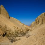
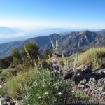
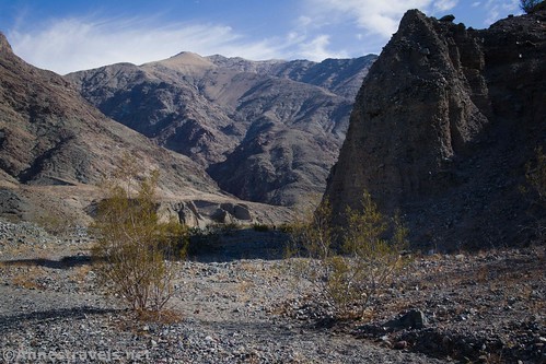
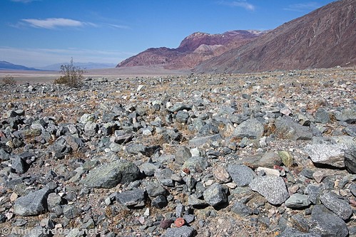
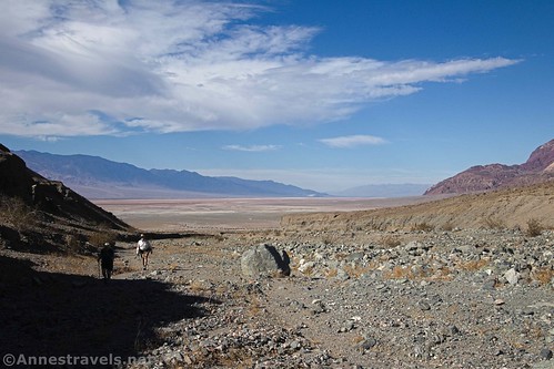
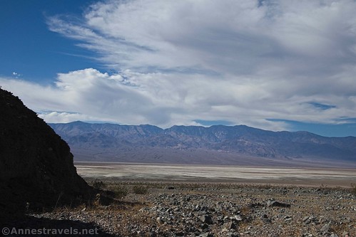
The trail heads north for about a mile over uneven rocky terrain. The trail itself isn’t too bad, but get off of it and it’s a classic, rocky alluvial fan. The rocks are quite pretty, the views across Badwater Salt Flats to the Panamint Mountains are beautiful, and the views to the nearby peaks and fins of the Black Mountains are rugged.
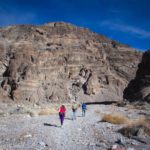
After about a mile, the trail turns right up Willow Canyon proper. At this point, there are multiple trails over gravelly terrain. It’s not too difficult hiking, thankfully; though there’s no question that you’re going uphill!
As you rise, the canyon slowly narrows. The walls aren’t very high, but you’re walking deeper into the Black Mountains.

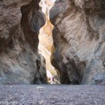
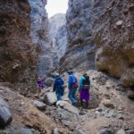
About a half a mile after starting up the canyon, the narrows finally begin. It’s still fairly wide (no claustrophobia here!) but definitely narrowing between sheer cliff walls.

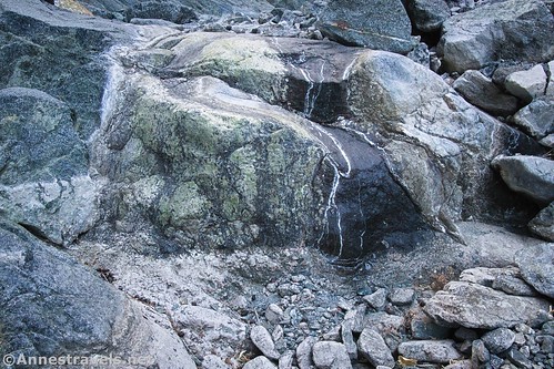
About mile 1.8, the canyon splits. Go left-ish up the main channel (by now, you may begin to see water – that’s a good sign!) A short distance later, a 6-foot dryfall must be negotiated – helpful hikers have piled stones beneath the lip of the dryfall, so it’s an easy Class 3 scramble.

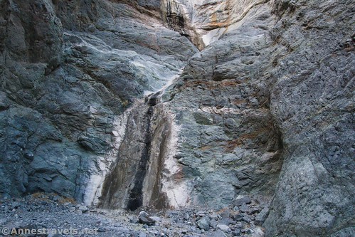
Keep walking upstream on rock that has been stained by the trickle of water. At 2.2 miles, the way up comes to an abrupt end at Willow Falls… or in my case, Willow Dryfall. You can see where the water has stained the rocks.

I’ve never heard of anyone who was able to scale the dryfall and continue upcanyon, though I have heard of hikers coming down from above (you’d need a map for that and possibly some canyoneering skills).

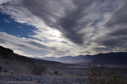
Retrace your steps to the parking area. While it’s not that exciting a hike when the waterfall isn’t flowing, at least you get some great views in the afternoon out on Badwater Flats on your way back down!
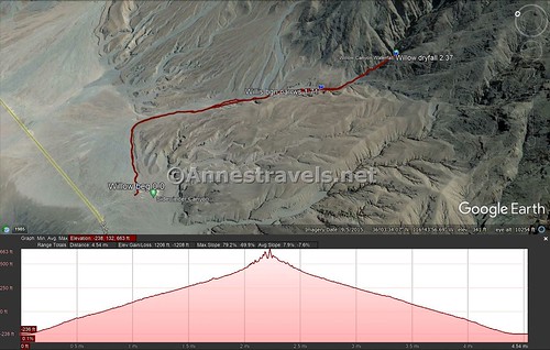
Round Trip Trail Length: About 4.4 miles – it’s a little hard for the GPS to get an accurate reading in a canyon.
Elevation Gain: 1,206ft. elevation gain (-238ft. to 663ft.) – I expect it’s less than this; as I said already, GPSes don’t like canyons very much.
Facilities: None
Fees: $30/vehicle, valid 7 days. National Parks & Federal Lands Passes and Death Valley Annual Passes are also accepted.

Trail Notes: Ask at the visitor center to see if the falls are flowing. They may or may not know, but most will at least give a stab at a guess. The rangers will also be happy to give you a printout of the trail if you ask about it. One of the truly great things about Willow Canyon is that it’s not a terribly popular hike – so while you might see people, you won’t see anywhere near as many as by hiking up Sidewinder Canyon.

Trail 
![]()
![]()
Road ![]()
Signs ![]()
![]()
![]()
Scenery ![]()
Would I go 100 miles out of my way for this? ![]()
Overall Rating: 
![]()

GPS Coordinates for Willow Canyon
Willow Canyon Trailhead: 36.0659167°, -116.7445167° (N36° 03.955′ W116° 44.671′ / 36°03’57.3000″, -116°44’40.2600″) (-239ft.) (0.0)
Begin Narrows: 36.0574000°, -116.7264833° (N36° 03.444′ W116° 43.589′ / 36°03’26.6400″, -116°43’35.3400″) (296ft.) (1.71)
Canyon Junction (go left-ish):36.055402, -116.724270 (393ft.) (1.8)
Dryfall: 36.0527833°, -116.7189667° (N36° 03.167′ W116° 43.138′ / 36°03’10.0200″, -116°43’08.2800″) (533ft.) (2.37)

The gpx file for Willow Canyon can be downloaded – please note that this and the GPS Coordinates are for reference only and should not be used as a sole resource when hiking this trail.
Download GPX File size: 142.5 KB Downloaded 355 times
(Note: I do my best to ensure that all downloads, the webpage, etc. are virus-free and accurate; however, I cannot be held responsible for any damage that might result, including but not limited to loss of data, damages to hardware, harm to users, from use of files, information, etc. from this website. Thanks!)
Getting to Willow Creek
From Furnace Creek, drive south on CA-190E. After a mile, turn right on the Badwater Road. Pass by many of the famous destinations of Death Valley, including Golden Canyon, Artist Pallet, and Badwater Basin. After 31.3 miles, a sign will indicate the Sidewinder Trailhead on the left (east). This is also the parking area for Willow Canyon, though you’ll want to head to the left (north) side of the gravel lot to park.
From CA-127 north of Shoshone, turn onto the Jubilee Pass Road. Drive 24.9 miles, then take the paved road as it turns sharply north at the junction for the Harry Wade Road for another 14.5 miles to the Sidewinder Trailhead, on the right (east). This is also the parking area for Willow Canyon, though you’ll want to head to the left (north) side of the gravel lot to park.

The parking area is gravel, but it should be passable by low-clearance vehicles under most circumstances.
This Week’s Featured Product!
This hiking guide covers almost 60 hikes in Death Valley National Park – from the famous strolls and epic explorations to hikes you’ve probably never heard of before.