

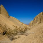
My favorite canyon we did in on our last visit to Death Valley National Park was Fall Canyon in the central part of the park. It even beat out Sidewinder Canyon, which is saying a lot since Sidewinder Canyon was just too much fun! But Fall Canyon has towering, colorful, beautifully formed walls and easier access, which is probably why I enjoyed it so much. I’ll also touch on how to access Upper Fall Canyon – further than most people go, but a slot that’s so beautiful!
Quick Stats
The Fall Canyon Trailhead is also the southern trailhead for Titus Canyon. Because of this, it’s very busy with vehicles coming down Titus Canyon, hikers heading up Titus, and hikers heading up Fall Canyon. Parking can be an issue during busy seasons. We took the second-to-last parking spot at about 9am on a Saturday in late fall.

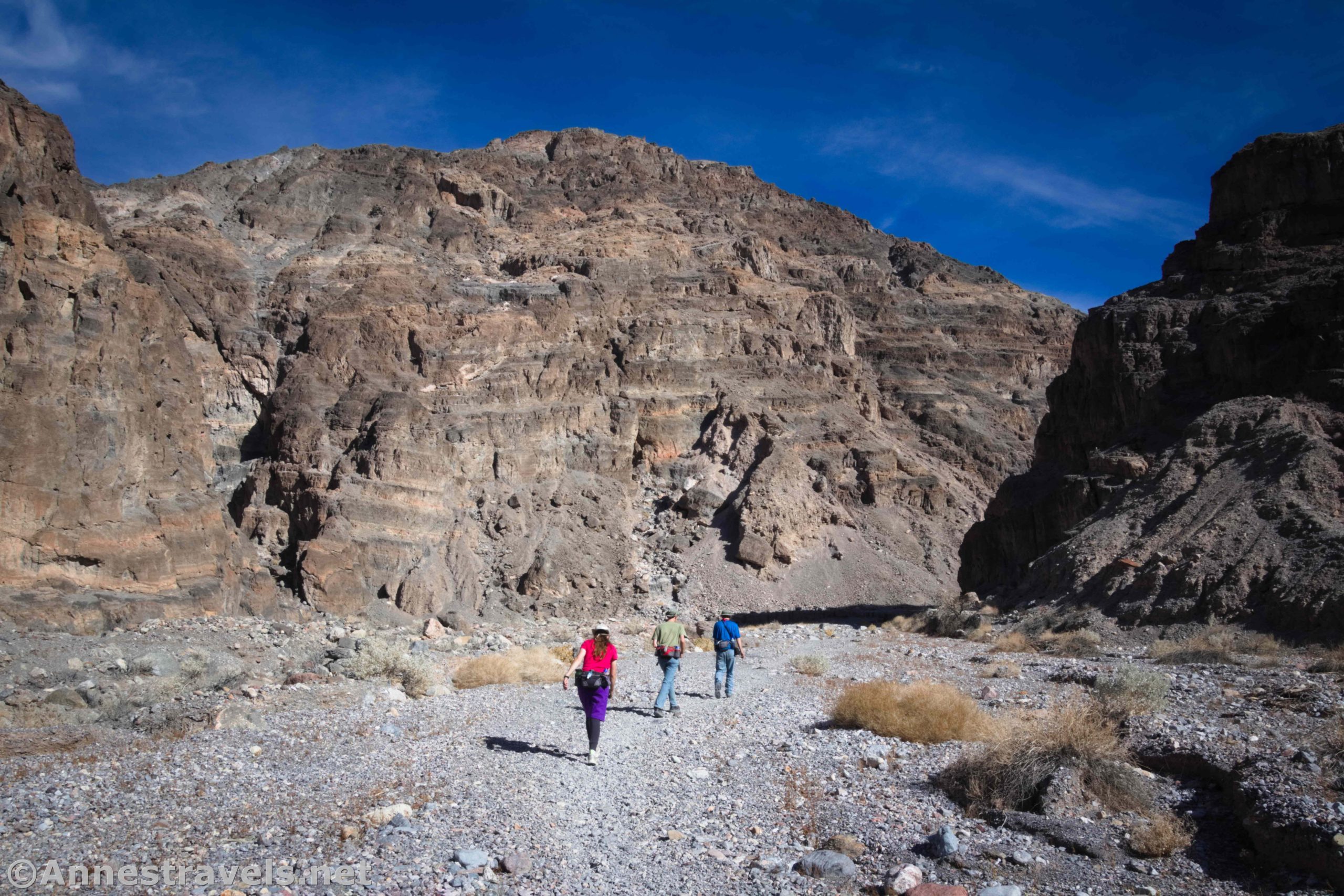
The trail begins behind the restroom (I feel like I say that a lot… I wonder why so many great trails start behind primitive restrooms?) You do not want to walk up the road into Titus Canyon (beautiful in its own right, but not where we’re hiking in this post). The Fall Canyon Trail travels along the base of the hills to drop into a streambed, then partially follows the streambed and partially follows a trail up and over small hills to drop into the Fall Canyon Wash.

There seems to be an old trail that drops into the wash a bit further downstream than the newer trail. Either way, turn right when you drop into the wide wash and you’ll soon come to where the hills rise and the walls of the canyon rise to form Fall Canyon. I dropped into the wash about mile 0.7 by following the newer trail.
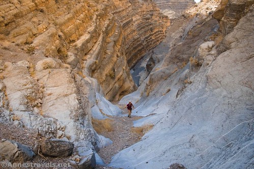
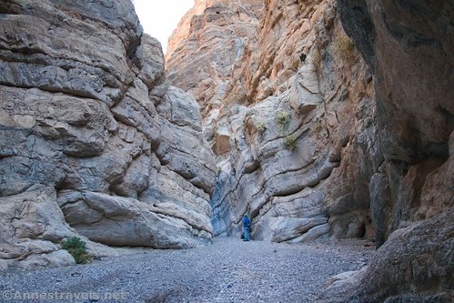
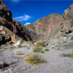
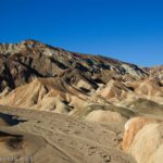
Fall Canyon is spectacular almost from the first. The streambed is gravelly with a slight upward slope. It’s not easy hiking, but it’s also not too hard, especially if you stick to the social trails. While you might have to walk around large rocks or other obstacles from time to time, there is no scrambling involved until after the canyon narrows about mile 3.2.

About mile 2, a side-canyon goes off on left. I’ve heard that there is an impressive dryfall a tenth of a mile up the side-canyon. However, while I saw people exploring the canyon, I did not explore it myself, so I’ll leave that discovery up to you.

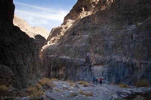
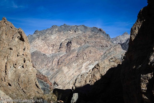
The canyon after the side-canyon is even more spectacular than before. The layers on the canyon walls take sheer cliffs to a whole new level. Some of the walls are multi-colored. It’s so easy to feel dwarfed here!
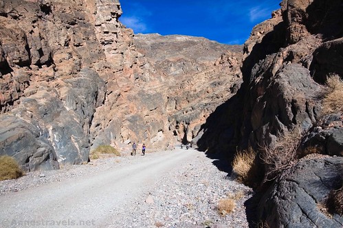
About mile 3.2, the canyon narrows. This is a new side of Fall Canyon. A few short scrambles (Class 2 or mild Class 3) lead upcanyon through this section.

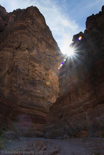
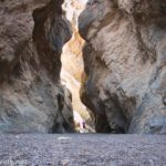
At 3.9 miles from the trailhead, the canyon suddenly ends in a small grotto at a 20ft. dryfall. (I measured the height of the dryfall using my GPS and ended up with 21ft.) It’s sheer and pretty much impassible without technical equipment.

This dryfall is where most people end their hike, retracing their steps to the trailhead. Granted, it makes for a fantastic hike. But if you don’t mind a bit of scrambling (Class 3 bordering on Class 4) there is more to see. And I loved it!

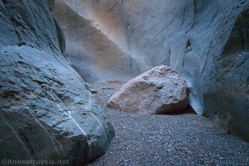
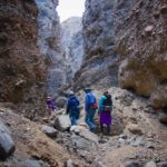
To access Upper Fall Canyon, from the dryfall, retrace your steps about 0.05 miles to a rock on the left (south; right when coming upcanyon) side of the canyon. It is uniquely shaped in that it has folds that rise into small bowls. The rock itself is white, with yellow/gray rocks above it. When I visited, someone had piled rocks in one of the bowls to give access to the next shelf up. This is the route to bypass the dryfall.

I found the first scramble to be by far the worst. It’s hardest for shorter people (like myself and another group member who is 5’2”), but the guys gave us a boost up. With good, grippy hiking boots and a lot of experience scrambling, I made it up the first stretch. From there, it was a Class 2 scramble into a drainage, up the drainage, then across the drainage (careful – it’s slippery) that felt a bit Class 4 due to the exposure, and finally onto solid ground of rocks. Head upcanyon and a rock shelf will drop you like a ramp down a few feet above the dryfall about 0.3 miles from where you headed up.

Sound complicated? We found cairns and followed them. And it’s not exactly easy. But if you’re good at scrambling, you won’t have too much trouble.
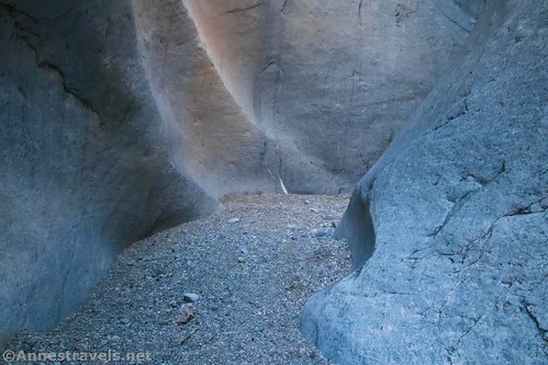
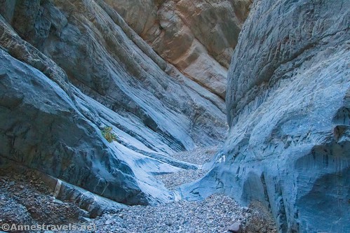
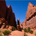
Upper Fall Canyon almost immediately treats you to a spectacular set of narrows. This isn’t like Sidewinder Canyon, where the narrows are tight and shallow. These are granite walls that close in in polished perfection. It’s not the narrowest canyon I’ve ever been in (by far), but it’s awesome.
The narrows come to an end after about 0.4 miles (mind you, my GPS may be exaggerating things – it’s claustrophobic even if I’m not). We sat down here for a snack and then retraced our steps downcanyon.

I’ve since read that if you go 0.1 miles further, you’ll come to the second (and probably last) set of narrows in Fall Canyon. If I’d realized that, I’d definitely have checked them out. But as it is, it’s up to your discovery!
Round Trip Length: Per my GPS, I went 9.0 miles. That’s 7.8 miles to the first dryfall and back. According to more accurate data, it’s 6.8 miles RT to the first dryfall and 8 miles RT to the end of the second narrows in Upper Fall Canyon.
Elevation Gain: About 2,652ft. (924ft. to 2,361ft. or 2,477ft.)
Facilities: Primitive restroom at the trailhead
Fees: $30/week to enter Death Valley National Park. America the Beautiful National Park passes and Death Valley Annual Passes also accepted.

Trail Notes: Much of this trek has no defined trail. But since you’re in a canyon, it’s sort of hard to get lost. Don’t hike this area if thunderstorms or rain are predicted or have happened recently. You can continue up beyond the last slot if you want – there is a (somewhat) passable 20ft. dryfall at mile 7.2 and a more difficult (potentially impassable) dryfall a tenth of a mile later. The canyon continues after this, but I have little or no information on where it leads.

Trail 
![]()
![]()
![]()
Road ![]()
Signs ![]()
![]()
![]()
Scenery
Would I go 100 miles out of my way for this?
Overall Rating: 
![]()
GPS Coordinates for Fall Canyon
Fall Canyon TH: 36.8221167°, -117.1740667° (N36° 49.327′ W117° 10.444′ / 36°49’19.6200″, -117°10’26.6400″) (718ft.) (0.0)
Streambed: 36.8279000°, -117.1757167° (N36° 49.674′ W117° 10.543′ / 36°49’40.4400″, -117°10’32.5800″) (1,126ft.) (0.48)
Enter streambed: 36.8305167°, -117.1743500° (N36° 49.831′ W117° 10.461′ / 36°49’49.8600″, -117°10’27.6600″) (1,186ft.) (0.70)
Narrows: 36.8469000°, -117.1548167° (N36° 50.814′ W117° 09.289′ / 36°50’48.8400″, -117°09’17.3400″) (1,982ft.) (3.17)
Dryfall: 36.8453333°, -117.1473167° (N36° 50.720′ W117° 08.839′ / 36°50’43.2000″, -117°08’50.3400″) (2,163ft.) (3.91)
Route Up: 36.8446667°, -117.1481833° (N36° 50.680′ W117° 08.891′ / 36°50’40.8000″, -117°08’53.4600″) (2,138ft.) (4.13)
Top of Dryfall: 36.8458833°, -117.1467833° (N36° 50.753′ W117° 08.807′ / 36°50’45.1800″, -117°08’48.4200″) (2,184ft.) (4.42)
Turn around: 36.8476167°, -117.1435167 (N36° 50.857′ W117° 08.611′ / 36°50’51.4200″, -117°08’36.6600″) (2,325ft.) (4.87)
End: 36.8221000°, -117.1739667° (N36° 49.326′ W117° 10.438′ / 36°49’19.5600″, -117°10’26.2800″) (978ft.) (8.99)
The gpx file for Fall Canyon can be downloaded – please note that this and the GPS Coordinates are for reference only and should not be used as a sole resource when hiking this trail.
Download GPX File size: 123.5 KB Downloaded 429 times
(Note: I do my best to ensure that all downloads, the webpage, etc. are virus-free and accurate; however, I cannot be held responsible for any damage that might result, including but not limited to loss of data, damages to hardware, harm to users, from use of files, information, etc. from this website. Thanks!)

Getting to Fall Canyon
From the Furnace Creek Visitor Center, drive north on CA-190W for 17.1 miles. At the sign marking it as such, turn right on Scotty’s Castle Road for 14.9 miles. Turn right on the dirt road marked for Titus Canyon. The trailhead for Titus Canyon and Fall Canyon is about 2.6 miles up the road.
From Stovepipe Wells, take CA-190E for 7.2 miles. Turn left on the road signed for Scotty’s Castle. After 14.9 miles, turn right on the dirt road marked for Titus Canyon. The trailhead for Titus Canyon and Fall Canyon is about 2.6 miles up the road.
Note that the parking area marks the end of two-way traffic. If you want to drive through Titus Canyon, you’ll need to take the Daylight Pass Road up to the northern end of the Titus Canyon Road.

You can also come down the one-way Titus Canyon Road to the trailhead. The Titus Canyon Road is high-clearance only; 4×4 required (or the road may be closed) when muddy, snowy, or washed out. Check with the visitor center for current road conditions.

This Week’s Featured Product!
With almost 60 hikes to choose from, there’s sure to be trails for everyone in this guide. It offers both famous trails and trail-less explorations to choose from.
One response to “The Lower and Upper Reaches of Fall Canyon”
[…] last day in Death Valley, we checked out Fall Canyon, near Titus Canyon. I loved that hike. The towering walls were beautiful, and we found […]