

I returned a few weeks ago from a fantastic trip to the American southwest! We hiked over 100 miles (despite the short days of November), laughed a lot, stargazed almost every night, and just had a wonderful time hanging out as adults in the slower-paced world of the desert. Oh – and we saw some amazing scenery, too! I’m sharing photos from each hike here… so you can look forward to what I’ll be blogging about for the next year or so!
(Affiliate links are present on this page.)
We drove straight to Death Valley, which would be our center of operations for 2 weeks. Our first hike (which was probably the most boring hike of the trip) was up into Willow Canyon:
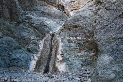
The next day, we took a gamble and tried for Grotto Canyon. We had to haul some of the group up the dryfalls via our clothesline (it doubles as a climbing rope from time to time), but what an awesome adventure!

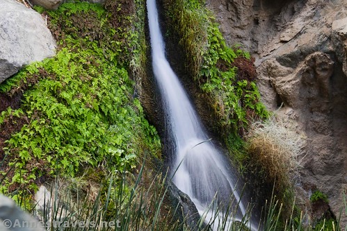
In the afternoon, we hiked to Darwin Falls. Who’d have thought Death Valley would have a year-round waterfall like this?
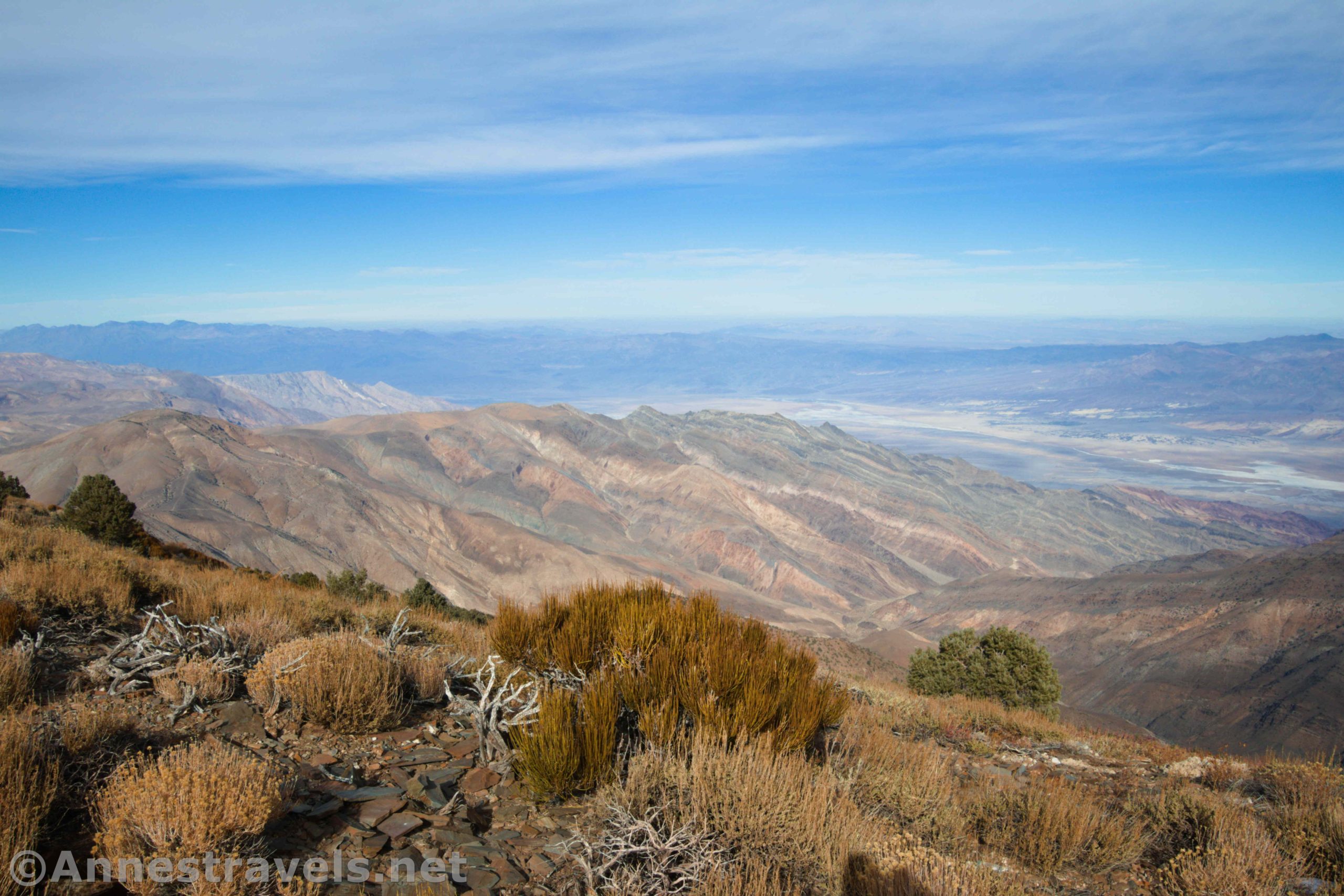
The next morning, we ate breakfast up at Father Crowley Vista overlooking Rainbow Canyon.

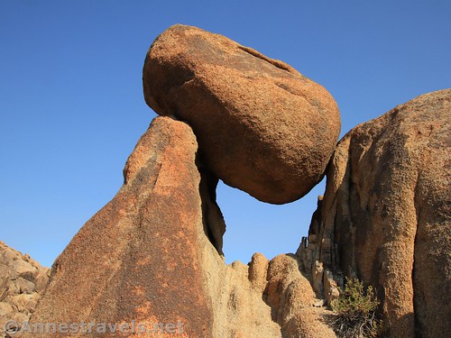
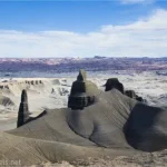
We arrived at the Alabama Hills (between Lone Pine and the Sierras) in time to hike the Arch Loop before lunch.
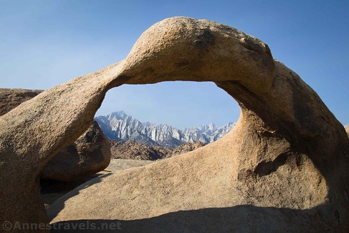
In the afternoon, we scrambled around to find arches, rock formations, balancing rocks, and great views!
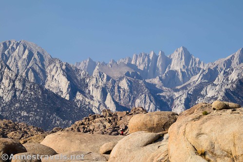
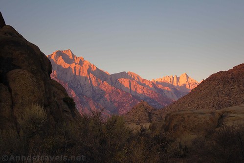
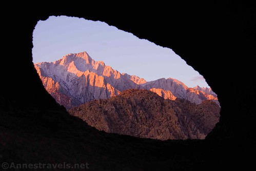
I got up early(ish) in the morning to catch sunrise over Mt. Whitney. Beautiful!
On our way back to Death Valley, we stopped at the Trona Pinnacles National Natural Landmark. The spires stick up out of an old lakebed.

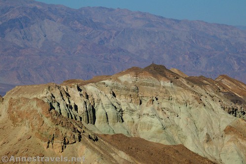
Back in Death Valley, we spent a very happy morning exploring around the 20 Mule Team Road. I trekked up a hillside or two…
…then explored 20 Mule Team Canyon. It’s pretty cool, with only one really sketchy dryfall to overcome.

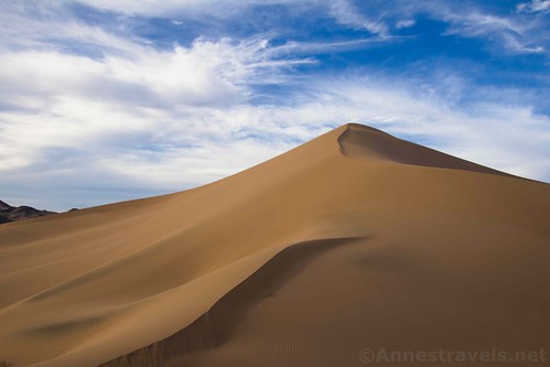
We drove down to the far southern part of Death Valley and got there in time to take the non-trail to Ibex Dunes before sunset.
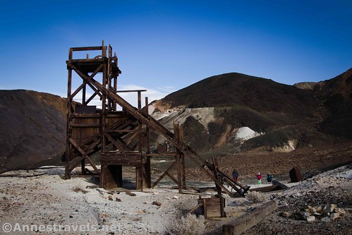
The whole reason we were down there was to hike the old mining road by Saratoga Springs the next day.

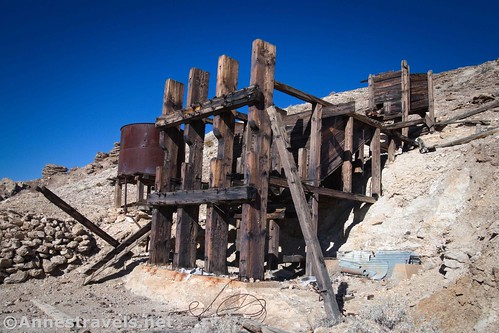
We found at least two mining areas with old structures. Very cool!
Our next adventure in Death Valley was to try to hike up Corkscrew Canyon, per instructions I’d found on the internet. Unfortunately, it’s apparently private property (even the rangers can’t tell you where the private property begins and ends), so we did our best to obey the signs and still managed to see some nice views. Sadly, we couldn’t get to the old mining stuff or the slot canyon.

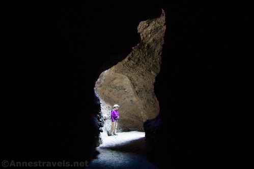
The next day might have been one of the most fun hikes we did on the entire trip: Sidewinder Canyon. We explored three out of five slot canyons, saw an arch, whispered within a dark part of slots, and climbed up and down more dryfalls than I can count.
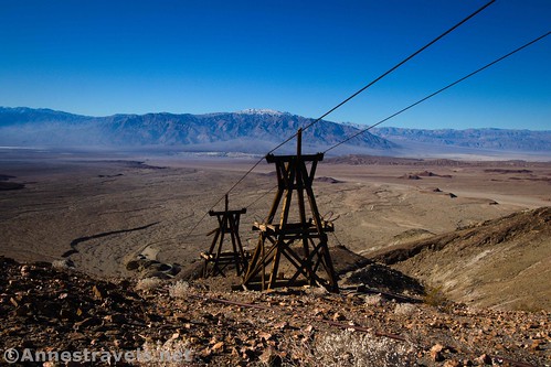
When I learned that the Keane Wonder Mine was once again open to visitors, I insisted we needed to visit one more time. The amazing thing is that it really hasn’t changed much except for the road in (which seems to have been washed out and then moved).
On the top of the list of “must-do” hikes for several of my group members was to hike across Death Valley. A first for about half of my group, the rest of us had only ever hiked it one way, never as an out-and-back. It was a hot, blinding 13 miles, but oh, the salt flats were beautiful!

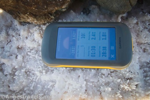
Along the way, we sought out the cairn marking the lowest place in North America – 282 feet below sea level!
We went back to the Alabama Hills for a day…
…then returned to Death Valley to hike up to John Cyty’s Mill.
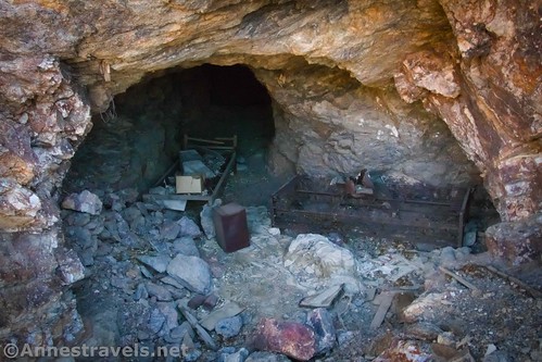
Feeling adventurous (well, I was anyway), we hiked up the old mine trail behind the mill. We didn’t make it all the way to the Big Bell Extension, but we did see several potential mine shafts and some fabulous views. Did you know that you can see both the lowest point in North America (Badwater) and the tallest peak in the contiguous US (Mount Whitney) from that trail?
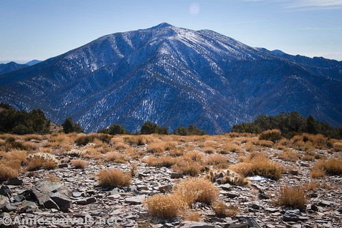
The steep climb up above the mill got us in shape to hike up Wildrose Peak (below Telescope Peak) the next day. What views! Snow on the trail didn’t keep us from the climb.
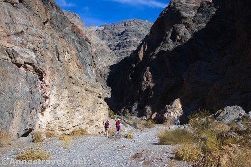
Our last day in Death Valley, we checked out Fall Canyon, near Titus Canyon. I loved that hike. The towering walls were beautiful, and we found a way around the dryfall that stops most hikers.
Above the dryfall, the canyon narrows down to a true slot with beautiful curving walls.

It was high time to be heading toward home, so we decided to take a side-trek to Moab. But first, we stopped at the snowy Sand Bench Vista on I-70.

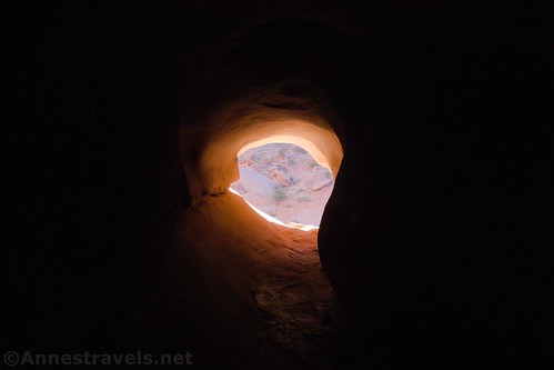
In Arches National Park, we took the mostly-trailless trek up Courthouse Wash to The Tunnel…
…and beyond to Ring Arch.

We had a few more hours of daylight, so we visited another off-trail area: Christmas Tree Arch.
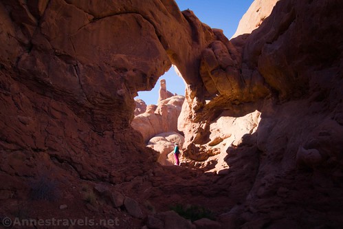
We were right on the Windows Loop, so we finished out the day by visiting the North and South Windows. It’s amazing how few people are on these trails when there aren’t any tour buses running!

The next day we hiked out to Murphy Point Overlook in Island in the Sky District of Canyonlands National Park. It was a beautiful morning view. We hung out and watched vehicles on the White Rim Road far below.
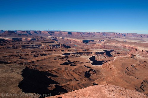
Then in the later afternoon, we hiked out to the White Rim Overlook. Talk about fabulous views!

I also caught sunrise the next morning from our campsite outside of the park.

Our last hike of the trip was to take the Lathrop Trail down toward the White Rim Road. None of us really wanted to hike all the way back up all of those switchbacks, so we only did part of the trail. But the views – oh, the views! It was totally worth the hike to see those views!

On the way, we stopped to see the Lathrop Overlook (it’s not official). You could stop right there and have seen glorious views.

I also got some pretty good star photos along the way. Short days mean lots of time hanging out stargazing (can’t complain about that!) My technique isn’t great yet, but I’m still pretty proud of this one.

And that was our trip! I’ll be posting more pictures and blog posts over the next many weeks!
This Week’s Featured Product!
Want even more trails in Death Valley? The authors cover more than 50 hikes within the park, from canyons to mountains and everything in between.
More Related Posts:
 Epic Day Hiking Road Trip to Southern Utah
 15 of the Best Day Hikes in Southern Utah
 The 6 Best Day Hikes in Arches National Park
 The top 15 Pages on Anne’s Travels in 2018!
 Best Hikes for Kids in Utah’s Big 5 National Parks + Grand Staircase-Escalante
 Trip Itinerary: Bryce Canyon, Capitol Reef, Hanksville, and more!