


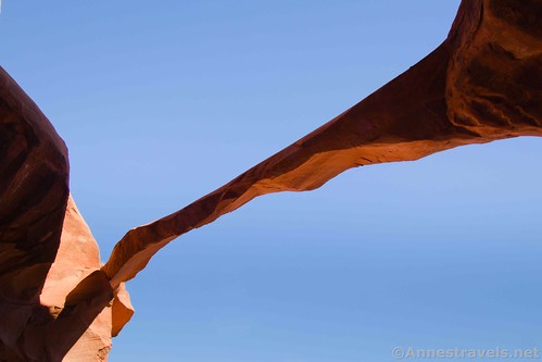
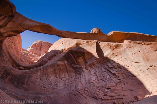
Ring Arch is a lesser-known arch near Courthouse Wash in Arches National Park. No official trail leads to it, but it’s often combined with (and is easier to find than) The Tunnel. The span is very thin and narrow, so I expect someday it will come crashing down. However, while it stands, it’s a beautiful, amazing arch that is a small adventure to discover.
Quick Stats
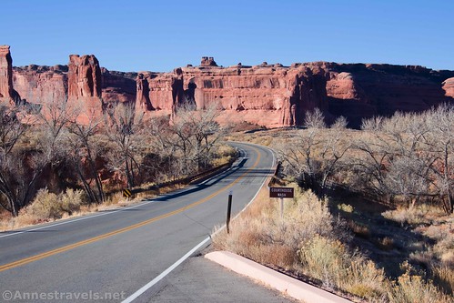
The trailhead is the same as for Lower Courthouse Wash – just after crossing the bridge over Courthouse Wash on the main road, park in a small pulloff on the west (left) side of the road. Instead of following the trails down Lower Courthouse Wash, take the trail on the west side of the bridge down to the wash, turn right, and hike up Upper Courthouse Wash.

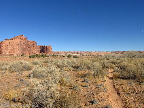
There are two ways to get to Ring Arch. The fastest way (which I took on the way back) is to follow social trails cross-country (you’d leave Courthouse Wash almost as soon as you entered it). The second route (the one I took on the way to the arch) is to follow Courthouse Wash for about 1.25 miles then turn up a side-wash and from there take an easy cross-country route to Ring Arch.
We were coming from The Tunnel, so we took the Courthouse Wash route on our way to Ring Arch. From The Tunnel, walk back down the wash to Courthouse Wash and turned right (west). Walk west about a quarter-mile to where a wash empties into Courthouse Wash from the south.

What we should have done here was to ascend the wash. There are a few dryfalls, but it should be passable. After about a quarter-mile, you’ll come to a place where the wash crosses (or at least runs next to) slickrock. One or more trails or sets of cairns should take you west from here to Ring Arch, which is quite visible and therefore easy-ish to find.

What we did instead was to follow a trail up (south) out of Courthouse Wash, then head generally in the direction of Ring Arch. While many social trails are visible on aerial imagery, they’re not so easy to find in real life. We ended up tramping across the desert in the midst of sticky desert grass, bushes, and rock-hopping to avoid cryptobiotic soil. It was seriously not fun! Thankfully, it was only about half a mile from Courthouse Wash to Ring Arch.

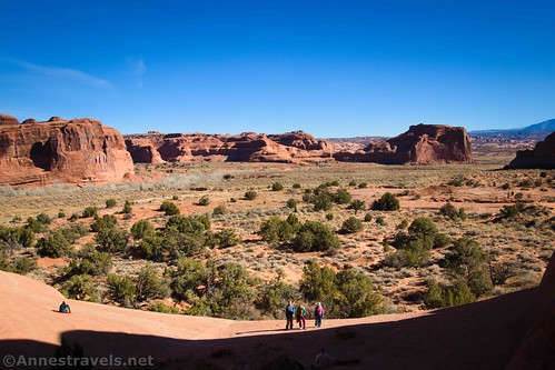
It’s not too difficult to locate where Ring Arch is, especially once you know where to look. Head for the left (near) side of the fin and you’ll see it eventually.

Ring Arch is best in the early morning; well before noon (at least in November) the arch is in shadow. So we took shadowed pictures of it and enjoyed the near-noon-time views across the meadow below the arch.
We tried to scramble up underneath Ring Arch, but the slickrock is so steep I had to give it up (in fact, I might or might not have stood where I was for about three minutes trying to figure out how to get down without falling flat on my face in the attempt). The view from underneath is cool, too, even if you don’t climb too far up the slickrock.
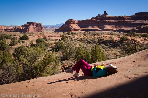
The views out over the meadow between here and Courthouse Wash and Park Avenue are also very scenic. The La Sal Mountains are pretty, too, though they are nicer in the afternoon than the morning.

We took the first route (cross-country) on the way back – there were social trails the entire way, so that made walking easy. There were occasionally cairns to mark the way.

Be sure to look over at Park Avenue along the way – the entire area is really gorgeous and quiet no matter which way you look!

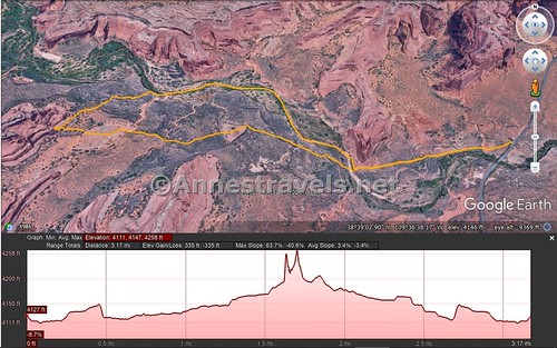
Round Trip Trail Length: I did 3.2 miles just to Ring Arch and back; with The Tunnel add about 1.6 miles.
Elevation gain: 335ft. (4,111ft. to 4,258ft.)
Facilities: None
Fees: $30/vehicle to enter Arches National Park; valid 7 days. America the Beautiful and Southeast Utah Park Passes are accepted.
Trail Notes: There is no trail, so be ready to way-find. In the summer, this trail is too hot to try, except possibly in the very early morning. Ring Arch is best in the morning light; in the mid-morning and afternoon, it is shaded by the rocks around it. For more adventures, you can continue up Courthouse Wash.

Trail 
![]()
![]()
![]()
Road ![]()
Signs ![]()
![]()
![]()
![]()
Scenery
Would I go 100 miles out of my way for this? ![]()
Overall Rating: ![]()
![]()

GPS Coordinates for Ring Arch
Ring Arch beginning: 38.6492833°, -109.5982833° (N38° 38.957′ W109° 35.897′ / 38°38’57.4200″, -109°35’53.8200″) (4,089ft.) (0.0)
Enter Wash: 38.6478333°, -109.6068000° (N38° 38.870′ W109° 36.408′ / 38°38’52.2000″, -109°36’24.4800″) (4,088ft.) (0.50)
Return to Courthouse Wash: 38.6528500°, -109.6128333° (N38° 39.171′ W109° 36.770′ / 38°39’10.2600″, -109°36’46.2000″) (4,225ft.) (2.75)
Where you should turn: 38.65234665300604, -109.6172444801724
Trail up: 38.6522667°, -109.6173833° (N38° 39.136′ W109° 37.043′ / 38°39’08.1600″, -109°37’02.5800″) (4,202ft.) (3.04)
Ring Arch: 38.6498833°, -109.6226167° (N38° 38.993′ W109° 37.357′ / 38°38’59.5800″, -109°37’21.4200″) (4,268ft.) (3.51)
Wash: 38.6498667°, -109.6188167° (N38° 38.992′ W109° 37.129′ / 38°38’59.5200″, -109°37’07.7400″) (4,146ft.) (3.78)
Courthouse Wash: 38.6484500°, -109.6080333° (N38° 38.907′ W109° 36.482′ / 38°38’54.4200″, -109°36’28.9200″) (4,100ft.) (4.49)
End: 38.6492667°, -109.5982833° (N38° 38.956′ W109° 35.897′ / 38°38’57.3600″, -109°35’53.8200″) (4,107ft.) (5.09)

The gpx file for Ring Arch can be downloaded – please note that this and the GPS Coordinates are for reference only and should not be used as a sole resource when hiking this trail.
Download GPX File size: 35.6 KB Downloaded 420 times
(Note: I do my best to ensure that all downloads, the webpage, etc. are virus-free and accurate; however, I cannot be held responsible for any damage that might result, including but not limited to loss of data, damages to hardware, harm to users, from use of files, information, etc. from this website. Thanks!)
Getting to Ring Arch Trailhead
From the entrance to Arches National Park at US-191, drive 5.4 miles through the entrance station, past the visitor center, up the hill, and past the two parking areas for Park Avenue. Just after crossing Courthouse Wash, park in the pulloff on the west (left) side of the road. Note that the pulloff 1) is unmarked, and 2) fills up quickly during warmer times of the year, when Lower Courthouse Wash is a popular hike. You’ll probably want to arrive early to secure a parking spot.
This Week’s Featured Product!
If you want a guide to the best hikes in Arches National Park, check out this book. It covers the author’s favorite hikes with detail trail descriptions, photos, and more.