

Last fall, en route back across the country, we took an unexpected side-trek to Arches National Park. I’d been reading about off-the-beaten-path arches in Arches, so our first hike was off-trail down Courthouse Wash to The Tunnel. As features in Arches go, this one was discovered fairly recently – it was first reported in 1979. It’s unique in that the feature is too long to be a typical “arch,” yet what else can you call a natural tunnel through the slickrock?
Quick Stats
The trailhead for The Tunnel is on the north side of Courthouse Wash. There is a small pulloff on the west side of the road. On a warm day, the pulloff will be filled to capacity and beyond with hikers heading down Lower Courthouse Wash. While I’m sure it’s a great hike, that wasn’t our destination on a chilly morning in November. Instead of taking the social trails on the east side of the road and downstream down Courthouse Wash, we took a social trail on the west side of the road that led down to Courthouse Wash and headed upstream.

Upper Courthouse Wash heads around a sandstone fin (on some maps called “The Great Wall”). Here social trails strike right out of the wash to head north. You probably don’t want to take these quite yet, though the social trails that parallel the wash may be easier to hike than the sandy wash bottom.

You have two routes to choose from when getting to The Tunnel. First, you can walk up Upper Courthouse Wash to the place where a major side-wash enters from the right (north) in a profusion of cottonwood trees. Follow this side-wash up and you’ll eventually run across The Tunnel. This was how we exited The Tunnel area, intent on other adventures. The way we walked to The Tunnel was cross-country, picking up one of the many social trails that headed north around one or two stone fins. This eventually dropped us into the side-wash a short distance below The Tunnel.

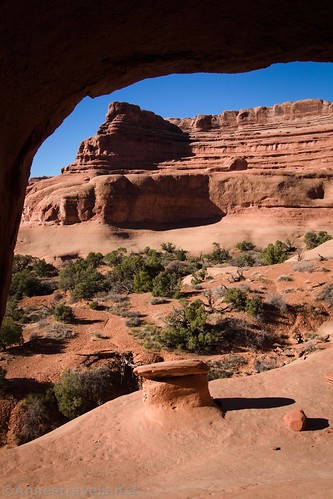
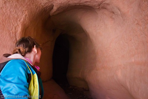
From a distance, The Tunnel is difficult or impossible to pick out. It’s just an innocent-looking pock in one of several sandstone fins. It’s easier to see the sandstone hoodoo on the slickrock directly below The Tunnel. So when you see the hoodoo, you know you’ve arrived!

Getting up to the hoodoo is easy enough; just a slickrock scramble. Getting up to the Tunnel is a bit more complicated. With good boots, plenty of slickrock-scrambling experience, and a hand to pull me up from above, I was able to scramble up to it. But that slickrock is steep! I’ve seen pictures online of people pulling up their companions using a rope. That would have been useful for a few members of the group with less-grippy shoes and/or shortness of stature. Taller people have an easier time with this… which is why the 5’5” and 6’ member of my group got up and I didn’t without a helping hand.

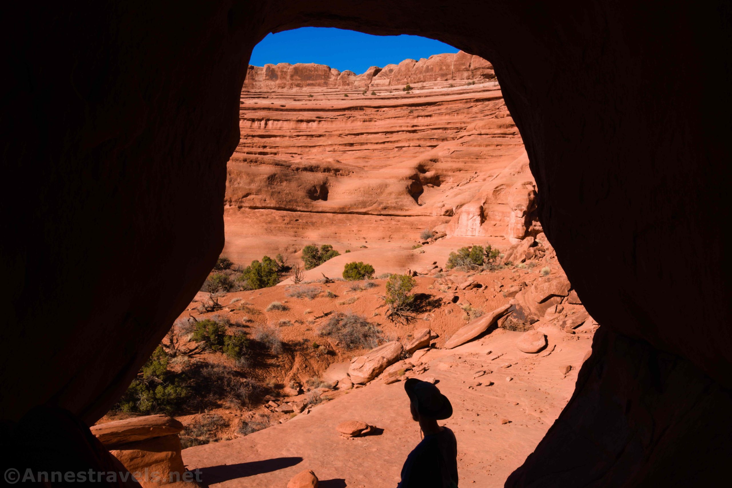
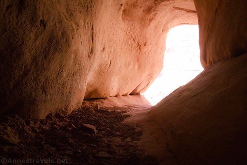
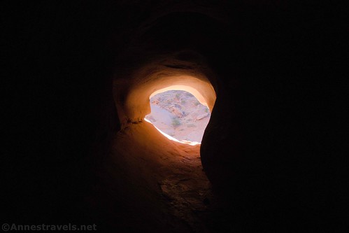
Inside of the tunnel is just fascinating. It’s about 4ft. wide, less than 5ft. wide in most places, and 53ft. long. You’re literally bent over walking through a sandstone fin. How cool is that?
We explored both ends of The Tunnel, but my favorite was taking photos of the nearby sandstone cliffs framed in the south exit to The Tunnel. The hoodoo looks pretty cool from up here, too.
When we tired of scrambling through The Tunnel, we hiked back down the side-wash to Upper Courthouse Wash. Our next destination was Ring Arch on the south side of Upper Courthouse Wash… but more on that in another post!

Round Trip Length: About 3.5 miles, depending on your route
Elevation Gain: About 348ft. (4,111ft. to 4,242ft.)
Facilities: None
Fees: $30/vehicle to enter Arches National Park; valid 7 days. America the Beautiful and Southeast Utah Park Passes are accepted.
Trail Notes: The entirety of this hike is off-trail. You should be very used to hiking in washes and across the desert backcountry before attempting to hike it. A rope might be helpful to haul children/small adults up into The Tunnel. Don’t try this in the summer, when it’s blazing hot out. Courthouse Wash may have water in it after rains. Use caution after rain, as Courthouse Wash is susceptible to flash flooding.
Trail 
![]()
![]()
![]()
![]()
Road ![]()
Signs ![]()
![]()
![]()
![]()
Scenery
Would I go 100 miles out of my way for this?
Overall Rating: ![]()
![]()

GPS Coordinates for The Tunnel
Ring Arch beginning: 38.6492833°, -109.5982833° (N38° 38.957′ W109° 35.897′ / 38°38’57.4200″, -109°35’53.8200″) (4,089ft.) (0.0)
Enter Wash: 38.6478333°, -109.6068000° (N38° 38.870′ W109° 36.408′ / 38°38’52.2000″, -109°36’24.4800″) (4,088ft.) (0.50)
The Tunnel: 38.6592667°, -109.6071667° (N38° 39.556′ W109° 36.430′ / 38°39’33.3600″, -109°36’25.8000″) (4,246ft.) (1.84)
Wash to The Tunnel/Courthouse Wash Junction: 38.6528500°, -109.6128333° (N38° 39.171′ W109° 36.770′ / 38°39’10.2600″, -109°36’46.2000″) (4,225ft.) (2.75)
End: 38.6492667°, -109.5982833° (N38° 38.956′ W109° 35.897′ / 38°38’57.3600″, -109°35’53.8200″) (4,107ft.) (5.09)

Due to the sensitive nature of the area, I am not uploading a GPX file to the Tunnel. My apologies for any inconvenience this might cause.

Getting to The Tunnel Trailhead
From the entrance to Arches National Park at US-191, drive 5.4 miles through the entrance station, past the visitor center, up the hill, and past the two parking areas for Park Avenue. Just after crossing Courthouse Wash, park in the pulloff on the west (left) side of the road.

This Week’s Featured Product!
If you’re interested in more trails in Arches, check out this book. Tristan calls himself an “opinionated” hiking book author, but he also makes sure you have all of the info you need to hike each and every trail.


3 responses to “The Tunnel in Arches”
This is a fun hike. I think I enjoyed Ring more than this one. Would love to hear about more “unknown” Arches arches hikes.
I can’t wait to post about Ring Arch; it’s spectacular. Our problem was that we got on the wrong trail (aka no trail) on our way to Ring Arch, so the hike wasn’t as enjoyable as it should have been! Here’s a link to a few lesser-known (and well-known) arches: https://www.gjhikes.com/2013/12/arches-national-park.html
[…] In Arches National Park, we took the mostly-trailless trek up Courthouse Wash to The Tunnel… […]