

Last November, while I was visiting Death Valley National Park, I decided to take a trip over the mountains to check out the Alabama Hills National Scenic Area. One of my favorite EPs from 2020 (actually late 2019, but who’s counting?) had its cover photography done there, so it seemed like the perfect time to check out the park.
Quick Stats

We did the Mobius Arch Loop – one of the very few trails in the area, and the only trail that seems to be well enough marked to follow – but that only took a half-hour or so, and we took our time. So we drove down one of the many dirt roads that loop through the Alabama Hills, found a place to park, and set off to explore the rock formations heading north and east.

We’re pretty used to hiking around without a trail, though most of the time dirt paths are appreciated. So setting off into the maze of rock formations – not to mention the labyrinth of dirt roads – wasn’t as crazy for us as it sounds. I had my GPS, and I figured if all else failed, I’d either 1) follow my GPS back to the van, or 2) head toward the Sierras and I’d hit Movie Road (the main road into the Alabama Hills) sooner or later.

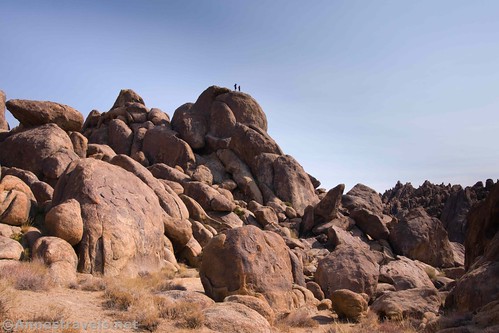
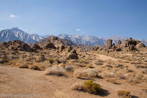
We headed up into the rocks, walking wherever we found a place to go and stopping to snap pictures of various arches, rock formations, the Sierras (better in the morning), and the general area. It’s a beautiful place!
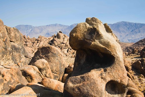
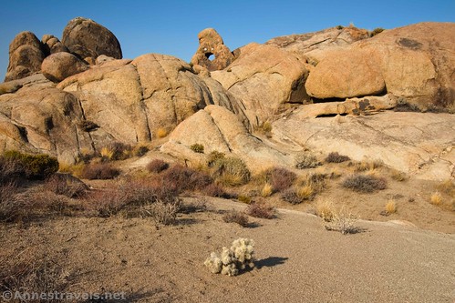
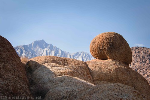
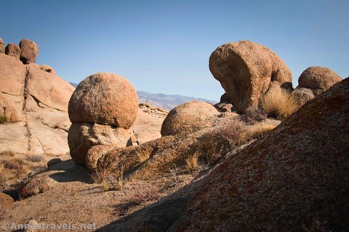
Mostly, I found rock formations. Some were carved into crazy shapes, others were just monoliths. I scrambled up more than one of the monoliths, and the views over the Alabama Hills and to the Sierras are spectacular.
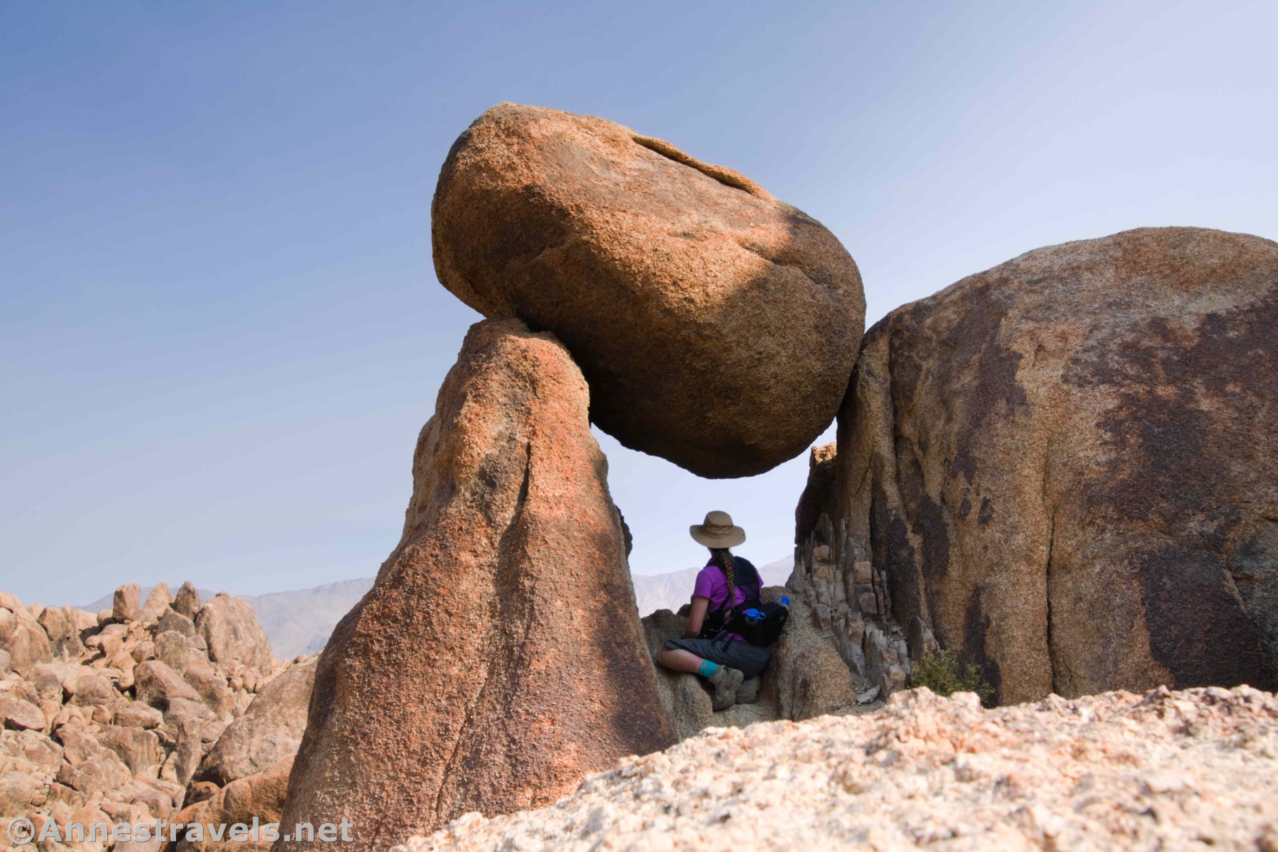
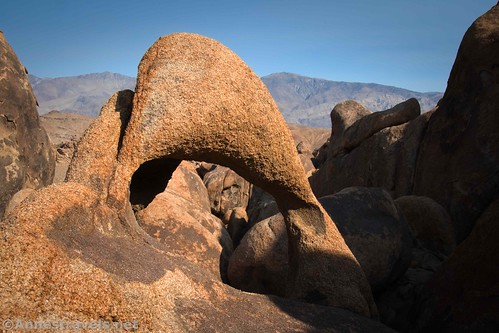
One of my favorite formations was a really cool balancing rock arch. It reminded me of the Balancing Rock in Big Bend (only smaller). I don’t know whether or not it has an official name.

Because it was November, there were only a few dozen people camping in the Alabama Hills. I’d say some of them were locals hanging out and others were just boondocking either for the night or for the duration.

In more popular times of year – Spring Break, for example – I’ve heard that there are so many people camping that exploring is almost impossible. You’ll finally get away from it all, go around a random rock formation – and oops, there’s a camper. I don’t know why some people expect complete privacy when they’re in a free unofficial campsite on public land, but I do understand not wanting to wander through someone else’s campsite. So all that to say, you’re better off doing exploration of the Alabama Hills on the off-season, probably non-holidays from late October to early March.

You’ll also not want to do this kind of exploration in the summer. It was hot enough in November (probably mid-80s), and there isn’t much of a breeze down among the rocks. The rocks also radiate the heat of the sun, so it can be pretty warm in there even in the shoulder season. (Wear sunscreen!)
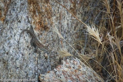
Another reason to hike in the Alabama Hills in the winter is that you’re less likely to run across, um, less-than-welcome wildlife. I saw a few lizards and a few birds, plus evidence of kangaroo rates and/or other rodents, but thankfully no snakes, scorpions, or poisonous spiders. Still, don’t stick your hand or foot into a crevice without looking first…!
No matter what time of year you explore, you’ll want to make sure you have food and water with you. Even a “short stroll” can become a desperate situation if you lose your way (not so very hard here) or chase “just one more arch.” Besides, it’s a lot more fun to see the sights when you’re not famished or dehydrated.

The roads and paths in the Alabama Hills have been the site for hundreds of movies and television shows over the years. There’s even a “Gene Autry Rock” and “Gary Cooper Rock,” named for famous movie stars. You may recognize rocks, arches, or scenery from various Westerns and TV shows as you wander through the rock formations.

Sadly, I don’t know most of the names of the arches I saw. I hear there is a book on Amazon that has the names of most of the arches and rock formations, so you can pick that up if it interests you. You can also visit this site that has a ton of information on the arches in the Alabama Hills.

Late in the afternoon, we decided that we should probably meet up with the rest of the group who we’d left back at the van. We returned to find that most of them had left on an adventure of their own on the west side of the road (still on the east side of Movie Road).

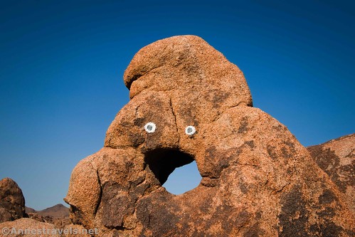
We followed the vague directions given us by those still at the van, and sure enough, we found the rest of our group by an arch with painted eyes. I’m not a fan of graffiti (to say the least!) but if it had to be done, at least this was tasteful and amusing. (I believe its official name is Old Tom Arch.)
I rambled my way back, visiting more rock formations. In general, the easterly portion of my hike was more scenic than the part nearer to Movie Road, but it’s possible that my desire for supper made it less scenic than if I’d just eaten lunch. Even so, it’s pretty cool, and it was easier walking than the more easterly portion.
Overall, it was a fantastic way to spend an afternoon! I did it again in a slightly different area a few days later, but I took so many photos that I figure that’s a topic for another post! (And be sure to check out sunrise, too!)
Round Trip Route Length: I hiked about 2.4 miles overall (it felt like more because of all of the scrambling)
Elevation Gain: 612ft. (4,551ft. to 4,711ft.)
Facilities: None
Fees: None

Trail Notes: Don’t try to explore the Alabama Hills unless you’re very used to hiking off-trail in the desert. Bring food and water, even for a short walk. You’ll probably cross the Alabama Hills Trail several times – from what I hear, it’s very difficult to follow, and you’re very likely to wander through campsites along its length.
Trail 
![]()
![]()
![]()
![]()
Road ![]()
![]()
Signs ![]()
![]()
![]()
![]()
Scenery
Would I go 100 miles out of my way for this?
Overall Rating: ![]()
![]()
GPS Coordinates for my Ramble in the Alabama Hills
Arch 1 (City of Arches; Silly Arch): 36.605210,-118.114979 (N36° 36.313′ W118° 06.899′ / 36°36’18.7800″, -118°06’53.9400″) (4,668ft.)
Arch 2: 36.6055000°, -118.1147667° (N36° 36.330′ W118° 06.886′ / 36°36’19.8000″, -118°06’53.1600″) (4,638ft.)
Balancing Rock: 36.6035500°, -118.1141667° (N36° 36.213′ W118° 06.850′ / 36°36’12.7800″, -118°06’51.0000″) (4,642ft.)

Balancing Rock 2: 36.6052833°, -118.1145833° (N36° 36.317′ W118° 06.875′ / 36°36’19.0200″, -118°06’52.5000″) (4,650ft.)
Arch 3: 36.6056833°, -118.1135500° (N36° 36.341′ W118° 06.813′ / 36°36’20.4600″, -118°06’48.7800″) (4,688ft.)
Arch 4 (probably Bucktooth Arch): 36.6056000°, -118.1132167° (N36° 36.336′ W118° 06.793′ / 36°36’20.1600″, -118°06’47.5800″) (4,700ft.)
Arch 5 (Old Tom Arch): 36.6015167°, -118.1184167° (N36° 36.091′ W118° 07.105′ / 36°36’05.4600″, -118°07’06.3000″) (4,600ft.)
The gpx file for my ramble in the Alabama Hills can be downloaded – please note that this and the GPS Coordinates are for reference only and should not be used as a sole resource when hiking this trail.
Download GPX File size: 90.0 KB Downloaded 430 times
(Note: I do my best to ensure that all downloads, the webpage, etc. are virus-free and accurate; however, I cannot be held responsible for any damage that might result, including but not limited to loss of data, damages to hardware, harm to users, from use of files, information, etc. from this website. Thanks!)

Getting to the Alabama Hills
In the town of Lone Pine, locate Whitney Portal Road (yes, this is the road that climbers use to access the trailhead for climbing Mt. Whitney). Whitney Portal Road begins in Lone Pine 1.9 miles north of the US-395 junction with CA-136 (which is the route you’d be taking if you’re coming from Death Valley National Park) or about 80 miles north of Ridgecrest or about 45 miles south of Big Pine.

Drive 2.7 miles west on Whitney Portal Road; you’ll pass a few signs for the Alabama Hills (including an information station with kiosks) and some rocks that have been painted. This area is owned by the City of Los Angeles, not the BLM, so camping and most other things aren’t allowed. Turn right onto Movie Road (there is a road sign) – it’s a dirt road, but it’s just fine for most vehicles in dry weather. After about 0.8 miles, turn right on a dirt road (high clearance is preferred). After about a tenth of a mile (or a little more), park your vehicle and begin exploring!

This Week’s Featured Product!
If you want to really get the best-of-the-best out of visiting the Alabama Hills, you need this book! It covers 72 arches plus guides to other points of interest.
One response to “A Ramble Through the Alabama Hills”
[…] the afternoon, we scrambled around to find arches, rock formations, balancing rocks, and great […]