Quite a while ago, I posted about rambling through the rocks in the Alabama Hills of southern California. I discovered fantastic views, cool arches, and lots of fun rock formations. Well, a few days later, I did it again – but as of yet, I haven’t posted most of those photos. So you’ll just have to enjoy this second attempt at discovery of as much as possible in a small area of the Alabama Hills.
Quick Stats
Note: Some of the links in this post are affiliate links. If you click one and purchase something, I may earn a small commission without an extra cost to you.

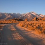
I started off from a campsite a short distance off the main road (Movie Road). At this time (January 2022), per the official BLM website, permits are not required for camping in the Alabama Hills (I’ve also read that they’re required from March-October, so just follow whatever guidelines are currently in place). When the permit system is implemented, camping will still be free.

You can only camp in established campsites. The good news is that there are a whole lot of campsites! In busier times of the year, the sites do fill up (to the point where exploring like I did becomes difficult, if not impossible), but in November, we felt we had quite a bit of privacy.

But back to my exploration: We scrambled up into the rocks. I’d explored this part of the Alabama Hills earlier, so I intentionally headed south and then looped east, north, and then back to where we’d parked the van.

Several group members explored nearby. They had their own adventures, and I’m not sure which of us had more fun discovering arches, great views, and much more.

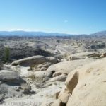
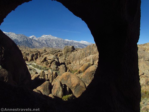
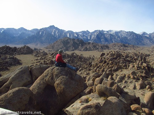
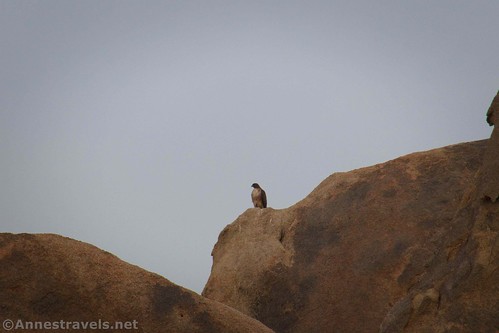
My first order of operation was to take some pictures of Mt. Whitney and the nearby Sierras. The views are better in the morning, though sunset is also pretty impressive.

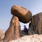
Some cool fins caught my attention.
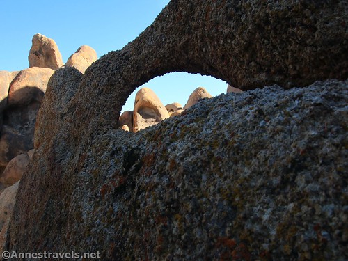
Then there was a fun arch.
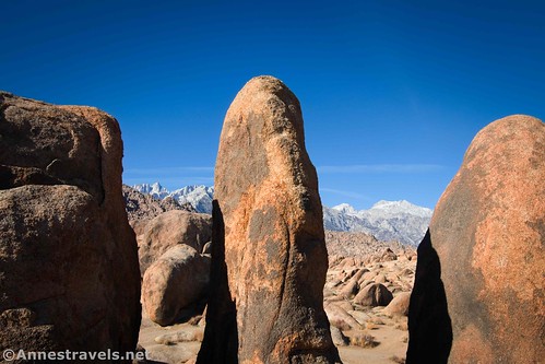
And an arch, fins, and a view of Lone Pine Peak!

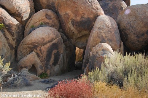
I also found an arch made up of boulders.
I continued to ramble around. There are fewer dirt roads in this area, so it’s a little wilder than the areas with more campsites. I wasn’t too worried about getting lost. First, I had my GPS with me, but second (and much more important to me) I knew I could always get high enough to see the Sierras, head in the direction of the mountains, and I’d hit Movie Road (the main road through the area) sooner or later.
Because this area is more remote than some parts of the Alabama Hills, fewer movies and television shows were filmed in this area. However, you might still find scenes that are similar to popular movies like Iron Man, Star Trek: Generations (and The Final Frontier), and many John Wayne films.

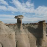
I photographed at least 6 different arches along the way. If they have names, I haven’t been able to identify them (yet!) I hear there’s a good book on Amazon that has the names of most of the arches. You can also visit this site for some of the arch names.

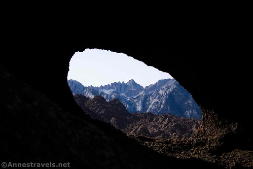
Eventually, I stumbled across Window Arch. It had a perfect view to frame both Mt. Whitney and Lone Pine Peak (though not at the same time). I marked it well so I could return to it to capture sunrise on the peaks the next morning!
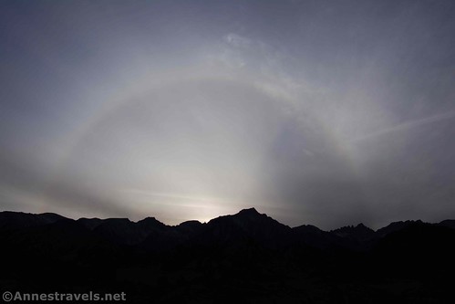
From there, it was a simple thing to hike cross-country back to where I’d parked. Most of the others had also finished exploring for the day, so we just had to set up camp, make supper, and enjoy the sunset!
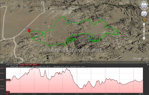
Round Trip Route Length: My ramblings took me 2.4 miles that day. You can easily make it shorter or longer depending on your current time constraints, interest, energy level, etc.
Elevation Gain: Varies. I supposedly did 761ft., but I’m not sure how accurate that is. Remember that much of it was scrambling up and over boulders, so it’s not an easy 700ft. of elevation gain!
Facilities: Primitive restrooms are located at six locations in the Alabama Hills. The BLM requests that you use these for solid waste and that you not bury your toilet paper.
Fees: None

Trail Notes: Don’t try this in the summer – it would be life-threateningly hot. Morning is best for views of the Sierras, but afternoon is good, too. Both sunrise and sunset are pretty awesome. Don’t try rambling very far if you’re not accustomed to wayfinding, off-trail travel, and have a pretty good sense of direction. Use care, as it would be pretty easy to get injured back in the rocks. Don’t forget food and water – it’s easy to lose track of time out here!

Trail 
![]()
![]()
![]()
![]()
Road ![]()
![]()
Signs ![]()
![]()
![]()
![]()
Scenery
Would I go 100 miles out of my way for this?
Overall Rating: ![]()
![]()

GPS Coordinates for Some Arches in the Alabama Hills
Arch 2: 36.6055000°, -118.1147667° (N36° 36.330′ W118° 06.886′ / 36°36’19.8000″, -118°06’53.1600″) (4,638ft.)
Arch 6: 36.6057833°, -118.1127833° (N36° 36.347′ W118° 06.767′ / 36°36’20.8200″, -118°06’46.0200″) (4,657ft.)
Arch 8: 36.6083000°, -118.1115500° (N36° 36.498′ W118° 06.693′ / 36°36’29.8800″, -118°06’41.5800″) (4,608ft.)
Arch 8a: 36.6078500°, -118.1143667° (N36° 36.471′ W118° 06.862′ / 36°36’28.2600″, -118°06’51.7200″) (4,605ft.)
Arch 9 (Window Arch): 36.6080000°, -118.1147333° (N36° 36.480′ W118° 06.884′ / 36°36’28.8000″, -118°06’53.0400″) (4,587ft.)
The gpx file for my ramble in the Alabama Hills can be downloaded – please note that this and the GPS Coordinates are for reference only and should not be used as a sole resource when hiking this trail.
Download GPX File size: 89.1 KB Downloaded 361 times
(Note: I do my best to ensure that all downloads, the webpage, etc. are virus-free and accurate; however, I cannot be held responsible for any damage that might result, including but not limited to loss of data, damages to hardware, harm to users, from use of files, information, etc. from this website. Thanks!)
Getting to the Alabama Hills
In the town of Lone Pine, locate Whitney Portal Road (yes, this is the road that climbers use to access the trailhead for climbing Mt. Whitney). Whitney Portal Road begins in Lone Pine 1.9 miles north of the US-395 junction with CA-136 (which is the route you’d be taking if you’re coming from Death Valley National Park) or about 80 miles north of Ridgecrest or about 45 miles south of Big Pine.

Drive 2.7 miles west on Whitney Portal Road; you’ll pass a few signs for the Alabama Hills (including an information station with kiosks) and some rocks that have been painted. This area is owned by the City of Los Angeles, not the BLM, so camping and most other things aren’t allowed. Turn right onto Movie Road (there is a road sign) – it’s a dirt road, but it’s just fine for most vehicles in dry weather. After about 0.8 miles, turn right on a dirt road (high clearance is preferred). After about a tenth of a mile (or a little more), park your vehicle and begin exploring!
This Week’s Featured Product!
If you want to really get the best-of-the-best out of visiting the Alabama Hills, you need this book! It covers 72 arches plus guides to other points of interest. Buy it here.