
Before I left for Utah last year, I was browsing one of my favorite websites about hiking in Utah. The author mentioned a nice exploration trek he took along the Kokopelli Trail east of Moab near Dewey Bridge to find two arches – Porthole Arch and Squaw Window. We took a gamble and followed his directions up the road. We did miss one turn, but otherwise it was a pretty easy hike along a dirt road to two fun little arches, not to mention fantastic views of the Colorado River, the La Sal Mountains, and more!
Quick Stats
Note: Some of the links in this post are affiliate links. If you click one and purchase something, I may earn a small commission without an extra cost to you.

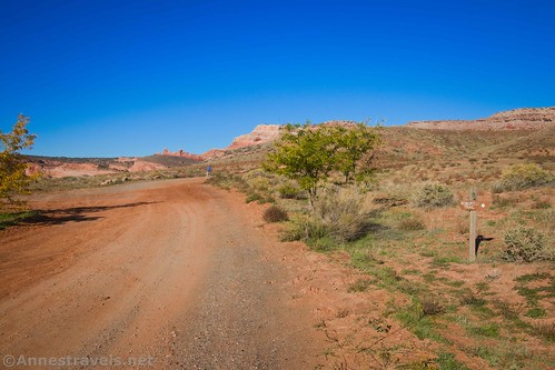
We started out by driving up the Kokopelli Trail (a marked dirt road located just on the east/north side of the Dewey Bridge). (Note: GoogleMaps calls this Owl Draw Upland, but the sign a short distance up the road says Kokopelli Trail.)
There is a parking area near the highway. We parked here, but if you have high clearance, you can continue a quarter of a mile up the road to a second parking area to cut off a little mileage.
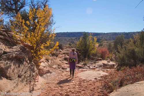
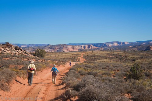
Walk up the road. (You can also drive if you have a good 4×4 vehicle; I hear the road was built for mountain biking, so you can also bike much of this route.) Views are almost immediately good back down on the Colorado River. You can also see Dewey Bridge.

As we walked along, the first of several groups of Ford Broncos came up behind us. The local Bronco Ranch takes guests up here to teach them how to drive off-road.
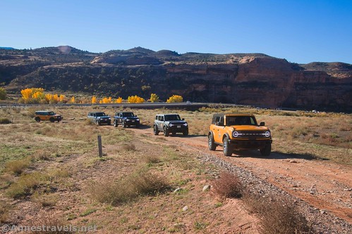
The staff couldn’t have been nicer and more respectful of us, making sure that we were able to walk where we needed to go without being in danger. The guests were also very nice – I’m used to some 4×4 enthusiasts resenting hikers on their routes, so it was great to find people who were just enjoying themselves and were happy to let us give way as well as give us safe passage up the hill.

The road winds its way up to the first real 4×4 hazard a short distance before mile 1.1. Just above the hazard is a wire gate. It wasn’t hard for hikers to get through, though if you open it, there is a sign requesting you to close the gate. We saw free-range cattle later on, so I’m guessing that’s why the gate is necessary.
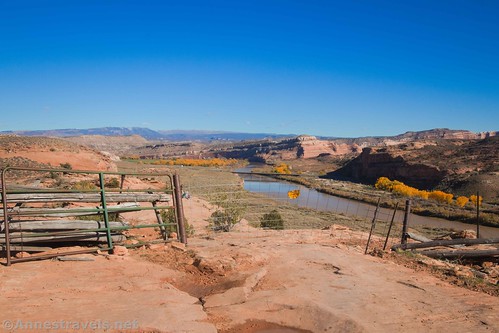
Be sure to take a good look around you up by the gate. The views down on the Colorado River are spectacular!

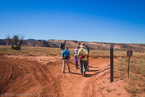
Keep walking along the road as it turns north around the outcropping of rock. About half a mile later, you’ll come to a spur road that goes off on the right, heading for an alcove. While it’s not a required side-trek, it was pretty cool. The entirety of our spur was 0.4 miles.

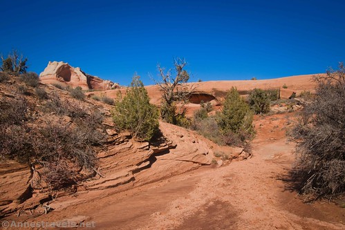
Walk another tenth of a mile along the main dirt road to the place where it crosses a wash. This is where you want to turn right, up the wash, to find Porthole Arch.

The arch itself is invisible from this angle. Just keep following the wash and social trails (don’t crush the fragile soil or leave footprints) into an alcove that looks like it has at least three minor alcoves in it.

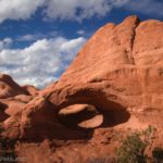
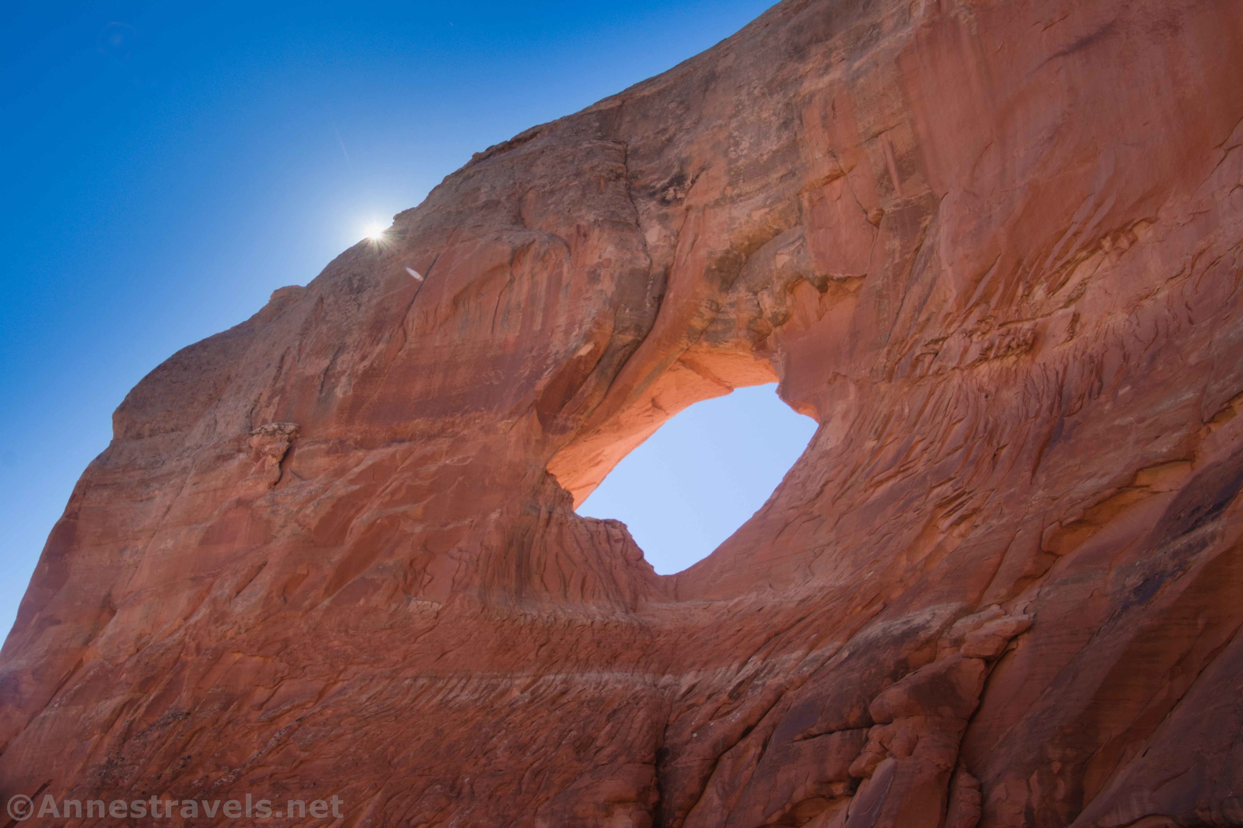
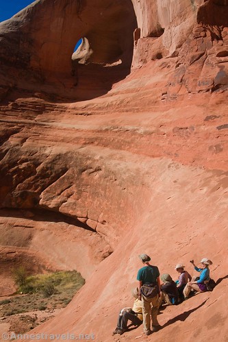
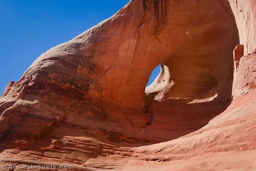
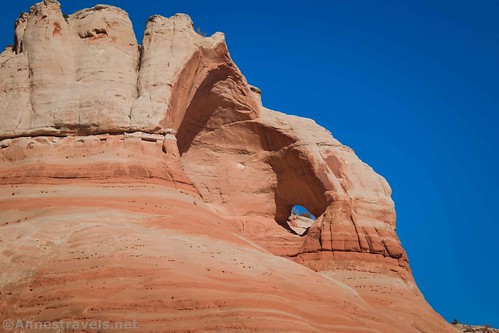
Once in the alcove (about 0.4 miles from the road), look up to the left and you’ll see Porthole Arch!

Unable to leave well enough alone, we scramble up the slickrock for a better view. You can’t climb up to the arch (it’s far too steep) but I did enjoy the views from higher up.
From here, we scrambled back down and took a cross-country shortcut back to the Kokopelli Trail. You can see the arch from the road if you know where to look: it’s also pretty obvious how the arch received its name!
Keep walking along the road as it rises to the top of a hill. About mile 3.4 (or about 0.9 miles from Porthole Arch), the road splits. You want to turn right (straight) following the sign for the Kokopelli Trail. (It seems the left road takes you down to a couple of overlooks of the Colorado River.)
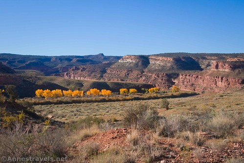
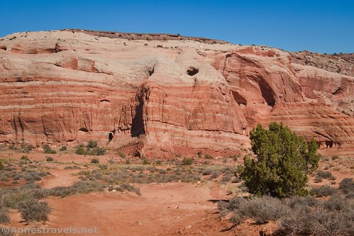
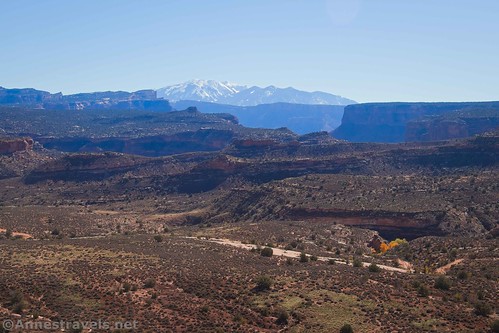
The road after this junction is incredibly scenic. To the left are cliffs with peek-a-boo views of the La Sal Mountains, while to the right are great views of red and white slickrock cliffs/formations. It’s beautiful!

We met a couple of people out in jeeps. Again, they were so very courteous. We moved over to let them pass.

What we should have done was, 0.9 miles after the junction, to turn right up a wash (the road crosses the wash, so it’s pretty obvious).

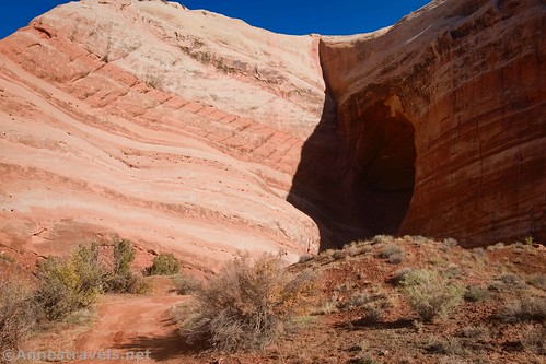
Unfortunately, my directions didn’t cover this very well, so we kept walking another 0.2 miles along the road until we could see the back side of Squaw Window.

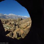
Realizing our mistake, we set off cross-country (being careful to stay on social trails, washes, or rocks to minimize our impact) to walk around and into the alcove where we could scramble up under the window.

We also scrambled around on the rock formations in the alcove.

The views were incredible from up here toward the La Sal Mountains. It was about noon, so the mountains were still a bit hazy.
On our way back to the road, we followed the wash we should have taken up to the arch. There are a few dryfalls, but nothing that can’t be easily scrambled. Interestingly, after the last waterfall (maybe 3-4ft. tall), the wash became full of cows’ hoof prints. Apparently, the cattle walk up the wash to the puddle below the last dryfall to find water.
Walking back, the views were even more spectacular to the rock formations, cliffs, and mountains to the east.

While I’m not usually fond of walking roads, the Kokopelli Trail is definitely worth the trek if you happen to be in the area! I’m sure it would be just as scenic from a bike seat or a jeep, too, though you’ll have to take to your feet to get up to the arches.
Round Trip Trail Length: 9.4 miles out & back to include both arches and the alcove
Elevation Gain: 2,860ft. (4,129ft. to 4,802ft.) (Actually, it’s probably slightly less than this since my GPS/GoogleEarth gets a little bit confused in the alcoves when it comes to just how high I’m hiking…)
Facilities: None
Fees: None
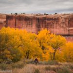
Trail Notes: Be wary and considerate of 4×4 vehicles that also use the road. Try not to trample the fragile soil by staying on the road/in washes/on slickrock whenever possible. You don’t need a GPS for this route but you do need to understand how to look for arches and find them without signs. This route would be extremely hot in the summer. If you can, hike in the area in mid-October, when the cottonwood trees are showing forth their golden leaves… it’s spectacular!

Trail 
![]()
![]()
Road ![]()
Signs ![]()
![]()
![]()
Scenery
Would I go 100 miles out of my way for this? ![]()
Overall Rating: 
![]()

GPS Coordinates for Porthole Arch & Squaw Window
TH: 38.813515, -109.303515 (38°48.81090′, -109°18.21090′ / 38°48’48.6540″, -109°18’12.6540″) (4,142ft.) (0.0)
Gate: 38.812770, -109.316962 (38°48.76620′, -109°19.01772′ / 38°48’45.9720″, -109°19’01.0632″) (4,297ft.) (1.10)
Road junction to alcove: 38.817921, -109.320173 (38°49.07526′, -109°19.21038′ / 38°49’04.5156″, -109°19’12.6228″) (4,261ft.) (1.58)

Alcove: 38.818913, -109.319597 (38°49.13478′, -109°19.17582′ / 38°49’08.0868″, -109°19’10.5492″) (4,318ft.) (1.78)
Leave road: 38.818181, -109.321587 (38°49.09086′, -109°19.29522′ / 38°49’05.4516″, -109°19’17.7132″) (4,250ft.) (2.12)
Porthole Arch Viewpoint: 38.819136, -109.323920 (38°49.14816′, -109°19.43520′ / 38°49’08.8896″, -109°19’26.1120″) (4,320ft.) (2.50)

Road Junction: 38.813080, -109.328159 (38°48.78480′, -109°19.68954′ / 38°48’47.0880″, -109°19’41.3724″) (4,489ft.) (3.43)
Leave road: 38.817655, -109.345423 (38°49.05930′, -109°20.72538′ / 38°49’03.5580″, -109°20’43.5228″) (4,500ft.) (4.52)
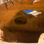
Squaw Window Viewpoint: 38.823405, -109.342795 (38°49.40430′, -109°20.56770′ / 38°49’24.2580″, -109°20’34.0620″) (4,564ft.) (5.10)

Squaw Window: 38.823530, -109.341419 (38°49.41180′, -109°20.48514′ / 38°49’24.7080″, -109°20’29.1084″) (4,594ft.) (5.14)
Return to road: 38.817976, -109.342918 (38°49.07856′, -109°20.57508′ / 38°49’04.7136″, -109°20’34.5048″) (4,437ft.) (6.28)
End: 38.813504, -109.303508 (38°48.81024′, -109°18.21048′ / 38°48’48.6144″, -109°18’12.6288″) (4,143ft.) (9.44)
The gpx file for my trek to Porthole Arch and Squaw Window can be downloaded – please note that this and the GPS Coordinates are for reference only and should not be used as a sole resource when hiking this trail.
Download GPX File size: 149.0 KB Downloaded 471 times
(Note: I do my best to ensure that all downloads, the webpage, etc. are virus-free and accurate; however, I cannot be held responsible for any damage that might result, including but not limited to loss of data, damages to hardware, harm to users, from use of files, information, etc. from this website. Thanks!)
Getting to the Kokopelli Trail
From Moab, Utah, drive north on US-191 (toward Arches National Park). Turn right on UT-128E at the traffic light just before crossing the Colorado River. (A sign will point right toward the Lions Park and Trail Hub.) Drive exactly 30 miles on UT-128, enjoying very scenic views along the river and of nearby red slickrock cliffs. Just after crossing the bridge over the Colorado River near the marker for Dewey Bridge, take a left onto a dirt road. A wide dirt area nearby can be used for parking.
From I-70, take Exit 214 toward Cisco. After 0.4 miles, turn left onto UT-128W; stay on the road for 11.5 miles. Just before the bridge over the Colorado River, turn right onto a dirt road. A wide dirt area nearby can be used for parking.

This Week’s Featured Product!
Discover the best of the dirt roads around Moab, Utah with this spiral-bound guide! Featuring 90 trails of varying difficulties, it’s a great resource for 4×4 enthusiasts, mountain bikers, and hikers who want to explore the dirt roads of the Beehive State. Buy your copy here!