


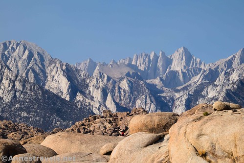
On our last trip to California, we mostly stuck to famous parks. But one of our few excursions outside of national parks was to the Alabama Hills to hike the Mobius Arch Loop. I’d read about it online, and it sounded so cool: Rock formations, arches, movie set locals, views to Mt. Whitney and nearby peaks… what could be better?
It was just as good as it promised to be (in fact, in some ways better than I’d hoped). The mountains are best in the morning, but the rock formations are good at any time of day. The roads are all dirt, so I wouldn’t recommend driving them in wet conditions… but otherwise it’s a great place to be!
Quick Stats

Our first experience of the Alabama Hills was to take the Arch Loop (more commonly known as the Mobius Arch Loop, but somehow the signs didn’t get the memo about the official trail name and call it the “Arch Loop”). This is the only reasonably findable hiking trail in the Alabama Hills. There are other trails, but we kept meeting people who were trying to find said trails in the maze of rock formations. At only 0.7 miles RT, the Arch Loop isn’t a long hike, but the views make it well worth the small amount of effort required to hike.

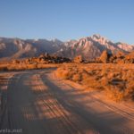
Note: The Alabama Hills are very hot in the summer. If you must hike in the area during the summer, do so in the very early morning (like, right after sunrise – the views are best then, anyway – or in the evening.) Also note that free-range camping is allowed in the area (check out sunrise photo here!), so chances are you’ll see a good number of small RVs set up here and there among the formations near the Movie Flats Road.
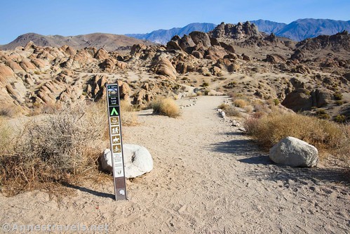
There are two trailheads for the Mobius Arch Loop since the trail is a loop. I started at the eastern trailhead (with your back to Mt. Whitney) so that I could hike the loop counter-clockwise, but it really doesn’t matter which direction you hike.
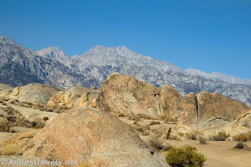
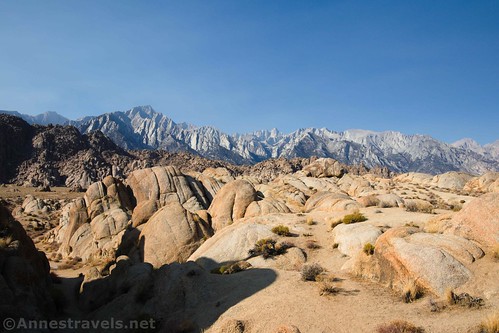
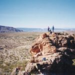
Almost immediately, the trail descends down into the rock formations. It twists and turns through the rocks, past strange spires and views to small arches (including Heart Arch). The views toward the Sierras along this section of the trail is stunning.

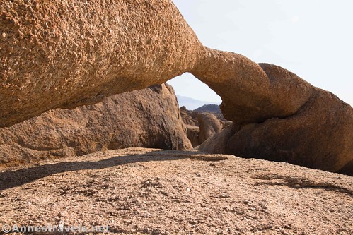
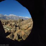
At mile 0.4, you’ll come to the main feature of the hike: Mobius Arch. It’s a favorite with sunrise photographers, who like to frame Mt. Whitney or Lone Pine Peak in the arch. Even in the morning well after sunrise, the views through it are stunning.

I’m sure Mobius Arch has shown up in many films, TV shows, and album art covers. But the only one I’m aware of at this time is a music video for a song from one of my favorite albums in 2020. You can view that video here. Actually, I didn’t know the artist (Kalley) had used the Alabama Hills as her filming location until after I’d already decided to visit the area. But it was super cool to try and find her filming locations!

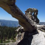
Right beyond Mobius Arch is Lathe Arch. It’s hard to get a good photo of it, but it’s long enough to be interesting.
The trail loops back around to the parking area through a few more rock formations and lots of expansive views. I reached the western trailhead at just less than 0.7 miles.
It’s not a long hike, but if you’re in the area and it’s not too hot, I highly recommend it – the views and the arches and the rock formations are outstanding!

Round Trip Trail Length: 0.7 mile loop. I’ve seen mileages ranging from 0.3 miles to 1 mile, but 0.7 was what my GPS said.
Elevation Gain: 131ft. (4,618ft. to 4,689ft.)
Facilities: None, not even restrooms. There are facilities (restaurants, gas stations, grocery stores, etc.) in Lone Pine.
Fees: None
Trail Notes: It’s probably best to stay on the trail in this area, more or less. Sometimes you can hike the entire trail without seeing a single person; I saw at least a half dozen other couples/families on the trail. It wasn’t busy by any means, but there were more people than I was expecting. Don’t hike this trail in the heat of summer. Horses, bicycles, and pets are also allowed on the trail.

Camping: This part of the Alabama Hills is administered by the BLM (Bureau of Land Management). Because of BLM regulations, dispersed camping is allowed, and you’re very likely to see more than a few RVs pulled into various sites up various dirt roads that spur off of Movie Flats Road. If you decide to camp, please do so in an already-established site (there are dozens!), respect all “do not drive here” signs, respect the rights and privacy of others, and pack out your toilet paper. Further east, the land is owned by the City of Los Angeles and camping is not allowed.
Trail 
![]()
![]()
Road ![]()
Signs ![]()
![]()
Scenery
Would I go 100 miles out of my way for this?
Overall Rating: ![]()
GPS Coordinates for the Mobius Arch Loop
Arch Loop eastern TH: 36.6113667°, -118.1247333° (N36° 36.682′ W118° 07.484′ / 36°36’40.9200″, -118°07’29.0400″) (4,639ft.) (0.0)
Mobius Arch: 36.6136000°, -118.1257333° (N36° 36.816′ W118° 07.544′ / 36°36’48.9600″, -118°07’32.6400″) (4,663ft.) (0.42)
Arch Loop western TH: 36.6113167°, -118.1250833° (N36° 36.679′ W118° 07.505′ / 36°36’40.7400″, -118°07’30.3000″) (4,638ft.) (0.68)
The gpx file for the Mobius Arch Loop can be downloaded – please note that this and the GPS Coordinates are for reference only and should not be used as a sole resource when hiking this trail.
Download GPX File size: 13.3 KB Downloaded 435 times
(Note: I do my best to ensure that all downloads, the webpage, etc. are virus-free and accurate; however, I cannot be held responsible for any damage that might result, including but not limited to loss of data, damages to hardware, harm to users, from use of files, information, etc. from this website. Thanks!)

Getting to the Mobius Arch Loop Trailhead
About the only logical way to access the Alabama Hills area is from Lone Pine, California, along US-395. Once in the town, you’ll want to locate Whitney Portal Road (yes, this is the road that climbers use to access the trailhead for climbing Mt. Whitney). Whitney Portal Road begins in Lone Pine 1.9 miles north of the US-395 junction with CA-136 (which is the route you’d be taking if you’re coming from Death Valley National Park) or about 80 miles north of Ridgecrest or about 45 miles south of Big Pine.
Drive 2.7 miles west on Whitney Portal Road; you’ll pass a few signs for the Alabama Hills (including an information station with kiosks) and some rocks that have been painted. This area is owned by the City of Los Angeles, not the BLM, so camping and most other things aren’t allowed. Turn right onto Movie Road (there is a road sign) – it’s a dirt road, but it’s just fine for most vehicles at least as far as the parking area for Mobius Arch Loop in dry weather.
The road passes a BLM sign welcoming you to the Alabama Hills and then enters fields with piles of rock formations. Keep your eyes open for arches; there are a fair number visible from the road. The road then crosses a wide, grassy area ringed with rock piles – this is Movie Flat, named for the sheer number of movies that have been filmed in the Alabama Hills (Wikipedia claims that 150 films have been shot here). Only 1.6 miles from the paved road, the dirt road will fork. Drive straight-ish right-ish into the unmarked parking area for the Arch Loop (brown survey-marker-type signs at the two trailheads tell you you’re on the right trail).
This Week’s Featured Product!
If you’re really looking for the arches that the Alabama Hills has to offer, this book is one-of-a-kind. With 72 arches and 23 other features detailed within its pages, you’re sure to find more than a few arches to identify along your hike – and possibly explore beyond the trail to find more.

One response to “The Alabama Hills’ Mobius Arch Loop”
[…] Whitney – the highest point in the contiguous US – from the Alabama Hills National Scenic Area, […]