

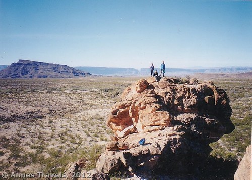
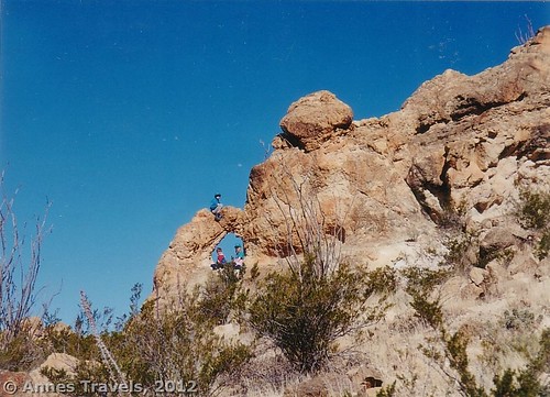
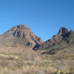
The Chimneys. They’re just rocks sticking out of the ground – nothing grand in the southern area of Big Bend National Park. Yet it’s quite an interesting destination. For one thing, there are petroglyphs on one of the Chimneys. I’m not personally fond of petroglyphs, but some people will walk miles to see the Indian pictures. Secondly, there’s also some Indian ruins at the base of another Chimney. Third, there’s an arch to be seen – it’s not huge, but it’s big enough to be memorable. (It’s also memorable to me because my dad took one of his favorite pictures of me through the arch the first time we visited Big Bend – now that was a long time ago!) Fourth, the Chimneys just fun to climb. The children in our group had a wonderful time scrambling on the surrounding rocks and even onto the tops of the Chimneys themselves. (At 6 miles (9.7 km) RT, the trail is short enough to be a nice dayhike with children who know how to hike.) Fifth, the Chimneys is typically a good place to find peace and quiet – every time I’ve hiked the trail I’ve been alone, even if there were other cars at the trailhead.
Key GPS Coordinates for The Chimneys:
The Chimneys Parking Area: 29.205792N / -103.423453 W (29N 12’ 20.8506”/-103W 25’ 24.4302”)
The Chimneys: 29.212532N / -103.459521W (29N 12’ 45.1146”/-103W 27’ 34.275”)
(Affiliate links are present on this page.)
Getting to The Chimneys:
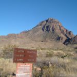
From the Panther Junction Visitor Center, drive 3 miles (4.8 km) west (left out of the visitor center parking area) past the road up to Chisos Basin, then another 10 miles (16 km) to the turnoff for Castolon/Santa Elena Canyon (also known as the Ross Maxwell Scenic Drive). Drive 12.8 miles (20.5 km) down this road; after the Burro Mesa Pouroff start looking for a small parking area on the right side of the road – I believe that the parking area is 1.2 miles (1.9 km) after the road for Burro Mesa Pouroff. There should be a metal sign (one that’s impossible to read unless you’re in front of it) that states that this is the Chimneys Trail. This parking area is about 14.5 miles north of Castolon.
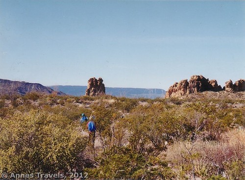
The trail isn’t hard to follow if you know what you’re looking for, especially since you can see the Chimneys from the parking area. (Though be forewarned that from here the Chimneys look a lot closer than they actually are.) A metal sign marks the beginning of the trail near the middle of the parking area, but that’s the last sign you’ll see until you return. However, you can easily follow the U-shaped path through the mesquite bushes. Actually, you’ll find a lot of desert fauna along this route; we discovered a blooming Christmas cactus one time we visited, as well as other desert plants – I hear that after a rain this part of the desert blooms profusely. Also, be on the lookout for animals. I’ve heard of several rattlesnake sightings along the trail, though with the noise my group made it’s no wonder we didn’t see much in terms of fauna.
My main memory of the trail, however, was the peaceful quite. If you stop, all you can hear is the wind in the mesquite bushes and perhaps an insect (cicada or something similar) buzzing nearby. Even car sounds can’t be heard. Wonderful!
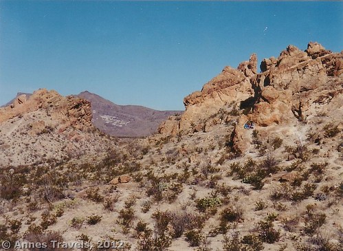
The trail is very flat and very exposed – it can be extremely hot in the middle of the day (I was freezing when we left in the early morning in December and frying by the time we came back around noon!). It rambles its way in a fairly straight line across the desert and, after not quite 3 miles (4.8 km), comes to the chimneys themselves. A short side trail leads to the Chimneys themselves. The petroglyphs are on one of the lone Chimneys, low down close to its base. Board cowboys shot it up a bit, but the petroglyphs are still very much intact. The Indian ruin is at the base of another Chimney. The arch is around the back of some of the Chimneys that are closer together on the northern side of the trail. The view from this area is also quite good; you can see the Santa Elena Canyon, Bee Mountain and Kit Mountain (over on your left), the Chisos Mountains, and Carosel Mountain and Elephant Tusk (to the right of the Chisos). It’s quite pretty, especially on a clear day.
Enjoy yourself scrambling around the Chimneys, and then return the way you came. If you have a shuttle vehicle, you could also keep walking another 6 miles (9.7 km) to the Old Maverick Road and Luna’s Jacal.
Round Trip Trail Length: 6 miles (9.7 km)
Facilities: None
Fees: $20 to enter Big Bend National Park; valid 7 days. America the Beautiful (Interagency), Senior (Golden Age), Access (Golden Access), Volunteer, Military, and Big Bend Annual Passes also accepted.
Trail 
![]()
![]()
Road
Signs ![]()
![]()
![]()
Scenery ![]()
Would I go 100 miles out of my way for this? ![]()
![]()
Overall Rating: 
![]()
This Week’s Featured Product!
Planning on hiking Big Bend? This little book offers maps and trail descriptions for nearly 50 different trails of varying lengths and difficulties within the park.


One response to “Fun on The Chimneys Trail, Big Bend”
[…] The Chimneys Trail (though this is a bit long with everything else you’re doing at 4.8 miles RT). […]