
Hiking the Oak Springs Trail in Big Bend National Park
After having visited Big Bend numerous times over the past several years, I thought I’d share what I’ve found to be the best hikes in Big Bend National Park, and which trails are overrated. Then, I thought, What if someone had a limited time in the park? Face it, even those who have all the time in the world are sometimes on a schedule for how long they can spend in a park. So, after the five “best” and five “worst” trails I’ve also broken down the “bests” by what to do if you have a limited time in the park (1 day, 3 days, a week, etc.).
The 5 best hikes in Big Bend National Park:
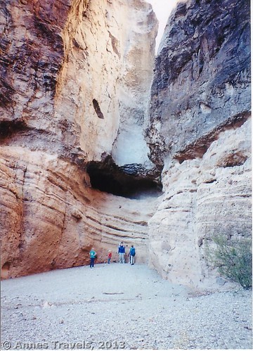
Overlooking The Den
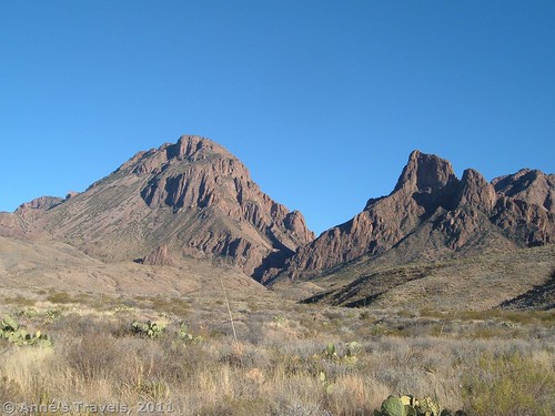
#5 The Den – If you love slot canyons or bouldering, this is the trail for you. The hike takes you to the beginning of the slot canyon from which you get to scramble up rocks and short dry falls through a pretty canyon. Fun, and usually not crowded (deserted, the day we did it). 5.6 mile RT; trailhead is near the Parsimmon Gap Visitor Center.
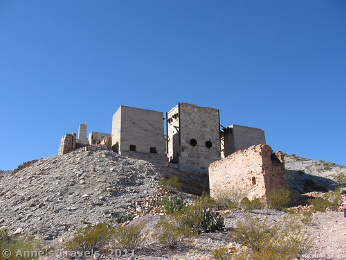
Mariscal Mercury Mine
#4 Mariscal Mine Trail – This short trail takes you to an old mercury mine refinery. The refinery is incredible in itself and offers some really nice photography opportunities, but you can also walk beyond it on an old mining road to views of the surrounding countryside. 0.5+ miles RT (depending on how far you walk); trailhead is along the East River Road. (High clearance may be required to reach the trailhead.)
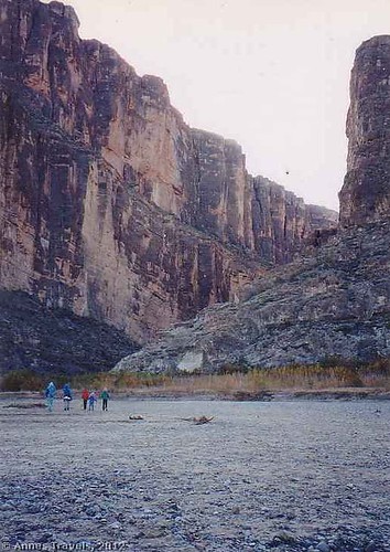
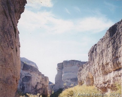
Santa Elena Canyon
#3 Santa Elena Canyon – A beautiful hike into an awesome canyon. You can also enjoy views back across much of Big Bend National Park. 1.6 miles RT; parking area is at the end of the Ross Maxwell Scenic Drive.
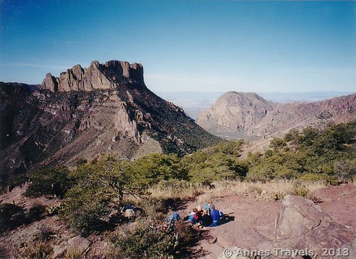
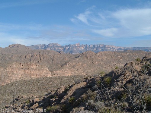
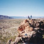
The Window from the Oak Springs Trail
#2 Oak Springs Trail – One of the most forgotten (though still used) trails in Big Bend National Park, this trail will take you up past great views of Big Bend to the famed Window. It’s a much better trail than the Window Trail from Chisos Basin. 5.5 miles RT if you walk the ¼ mile down to the Window itself; the trailhead is along the Ross Maxwell Scenic Drive.
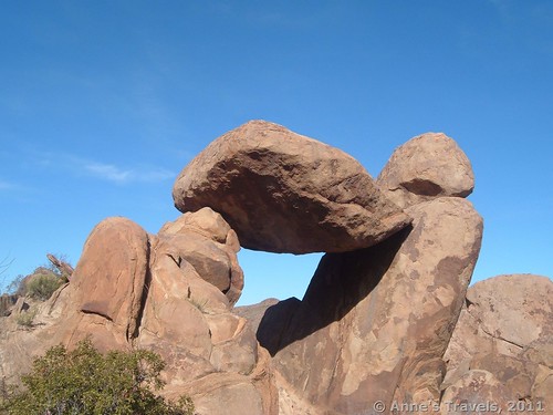
The Big Balancing Rock at Grapevine Hills
#1 Grapevine Hills Trail – The trail itself isn’t so wonderful; it’s what’s at the end of the trail that’s what makes this one of my favorite trails in Big Bend. The Big Balancing Rock seems to defy gravity as it sits atop two other large boulders. The views if you climb up the surrounding hillsides are also beautiful in a rustic sort of way. 2.2 miles RT; trailhead is located along the Grapevine Hills Road (high clearance is an asset).
Bonus – South Rim Trail – I’ve never hiked this trail, but the pictures I’ve seen are incredible. 12 miles RT; trailhead is in the Chisos Basin.
The 5 Most Overrated Trails in Big Bend:
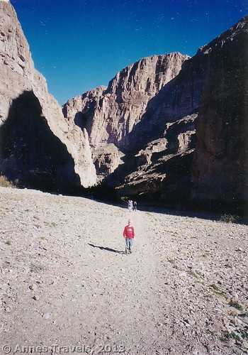
Boquillas Canyon
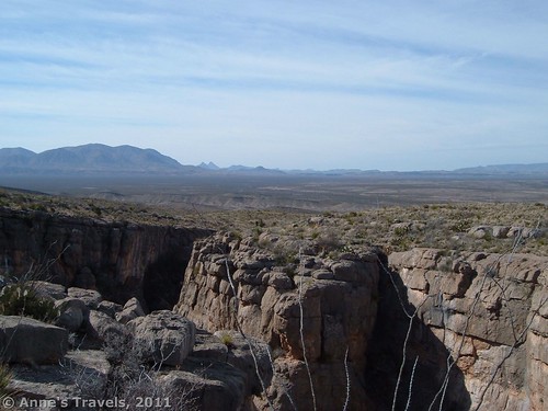
#5 Mariscal Canyon Rim – The views on this trail are ok…but the trail is long enough that I feel it’s overrated. If you’re desperate for a hike from the River Road, Mariscal Canyon Rim will fit the bill. You can even camp in Talley 1, 2, 3, or 4 before setting out. 6.6 miles RT; trailhead is at the Talley Campsites.
#4 Boquillas Canyon Trail – This trail is overrated because it’s a very short hike with very little reward. Yes, the canyon walls are nice, but the trail quickly peters out into nothing. The sand dunes were fun, though their charm was dimmed a bit by the Mexicans hawking wares from the other side of the river. 1.4 miles RT; the trailhead is near Rio Grande Village.
Hiking the Window Trail
#3 Window Trail – Very steep, strenuous, crowded, awkward trail. Once you leave the Chisos Basin, there are no more views until you reach the Window itself. Its only redeeming value is that you get to cross the creek four or five times near the bottom of the trail. 5.6 miles RT; Trailhead is in the Chisos Basin.
#2 Hot Springs Historic Trail – The trail isn’t terribly overrated, but the hot springs are. It sounded fun: you can swim in 105 degree water while the chilling Rio Grande flows only feet away. However, the springs are full of the nastiest, gooey, grey mud…never again! 1 mile RT; Trailhead is at the end of the Hot Springs Road (near Rio Grande Village).
Trying to find a view at the end of the Lost Mine Trail
#1 Lost Mine Trail – This has got to be one of the most overrated trails in the park (maybe in the entire national park system). It’s a fairly long hike that switchbacks forever upward to…nowhere. Ok, there’s a small view. But it certainly isn’t worth the hike. The trail is also very crowded, since if you walk into the visitor center and ask about hiking trails, they’ll tell you the Lost Mine Trail is great. But I say: don’t bother. 4.8 miles RT; trailhead is along the Basin Road. UPDATE: I’ve received numerous comments from other hikers on how much they enjoy the Lost Mine Trail. So while I guess it’s not my cup of tea, it apparently is well-loved! Glad to know that such a popular trail actually might be worth doing! Maybe I’ll even give it another try next time I visit Big Bend…
My Favorite Scenic Drives in Big Bend:
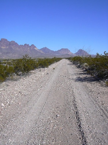
The West River Road
The River Road – This 51 mile dirt/gravel road offers some of the best classic Big Bend Scenery available. You can camp at multiple campsites along the road (see the link), and hike at a few places, but it’s really meant for slowly driving, enjoying the Chisos Mountains and the Rio Grande River. The west end (West River Road) can usually be accessed by low-clearance vehicles; the East River Road and the middle of the road (especially) usually require high clearance; 4×4 may be required at some times of year.
Ross Maxwell Scenic Drive – The 30-mile Ross Maxwell Scenic Drive showcases the geology of Big Bend National Park. The road begins by skirting the western edge of the Chisos Mountain Range, then turns westward, passing historical sights, canyons, and plenty of desert, to end at Santa Elena Canyon. The views of the cliffs along the Mexican border make this road a highlight.
All the roads offer some kind of view, so these are just my favorites!
If You Have 1 Day in Big Bend National Park:
Assuming you’re already in the park in the early morning and you’re great hikers:
Approaching the Chimneys
-
- Stop at the Oak Springs Trail and hike up to the famed Window. (5.5 miles RT; we did it in an afternoon (and we’re not the fastest hikers in the world; I think we averaged 2 miles/hour).)
- Stop and hike Santa Elena Canyon (1.6 miles RT).
- Use any leftover time to visit other attractions on the Ross Maxwell Scenic Drive:
- Drive the Ross Maxwell Scenic Drive, and see whatever of the following most interest you:
- Sam Neil Ranch – short loop leads around old houses and windmills. 0.5 miles RT.
- Homer Wilson Ranch – short trail to see the old structures of the Homer Wilson Ranch, which are on the National Register of Historic Places. 0.5 miles RT.
Lower Burro Mesa Pouroff
- Sotol Vista Overlook – overlook of classic Big Bend scenery.
- Lower Burro Mesa Pouroff – short trail to a huge dryfall. It’s fun to look up, up, up to the top. 1 mile RT.
- The Chimneys Trail (though this is a bit long with everything else you’re doing at 4.8 miles RT).
- Mule Ears Viewpoint – view of the “Mule Ears”, tuffs of rock that stand out from the otherwise fairly flat desert.
- Tuff Canyon – cool little canyon that’s great for children to play in and for geology buffs.
- Castolon – a small village with a store; interesting for its historical value.
- If you’re a power hiker, visit the Grapevine Hills Trail (2.2 miles RT) and then head down the Ross Maxwell Scenic Drive. (The Big Balancing Rock is best seen in the morning).
Not a grand hiker, or want a more relaxed day?
-
Tuff Canyon
Visit the Grapevine Hills Trail (2.2 miles RT)
- Drive the Ross Maxwell Scenic Drive, enjoying the sights along the way (see above), leaving yourself enough time to take in Santa Elena Canyon. (1.6 miles RT)
If you have 3 days in Big Bend National Park:
The view from Emory Peak
- Hike/drive the areas noted above
- Hike to The Den if you like scrambling (5.6 miles RT)
- Hike the Chimneys Trail for a slightly more relaxed hike (great for children who enjoy scrambling on the Chimneys themselves; there’s also some petroglyphs on the Chimneys) (4.8 miles RT)
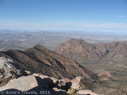
- Hike up Emory Peak (10.5 miles RT)
If you have 1 Week in Big Bend National Park:
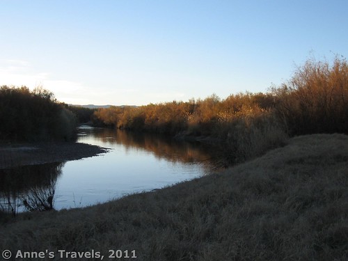
The Rio Grande at the former Woodson’s Campsite
- Spend two days driving the River Road (51 miles) (I’ve driven the road both from east to west and west to east…I might recommend starting at the west (Castolon) end, though both are very nice).
- At the very least, stop at Mariscal Mine
- If you
camp at Woodson’s orhave 4×4, visit Petite Overlook - Just take your time…this road has plenty of places to simply look!
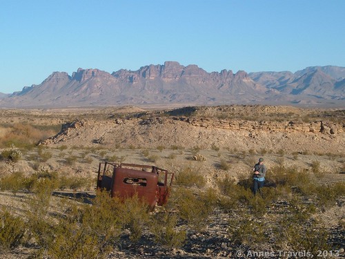
An old car at Petite Overlook
- Hike all of the “5 Best Hikes”
- #5 The Den (5.6 miles RT)
- #4 Mariscal Mine Trail (0.5+ miles RT)
- #3 Santa Elena Canyon (1.6 miles RT)
- #2 Oak Springs Trail (5.5 miles RT)
- #1 Grapevine Hills Trail (2.2 miles RT)
- Spend a day (at least) along the Ross Maxwell Scenic Drive (see above)
- You could also hike:
- The Chimneys Trail (4.8 miles RT)
- Telephone Canyon & the surrounding area (8 miles RT; give or take several miles)
- Emory Peak (10.5 miles RT)
Along the Telephone Canyon Trail
Big Bend National Park is a great place to go in the winter months (November-March)…so enjoy your stay!
Fees: $20 to enter Big Bend National Park; valid 7 days. America the Beautiful (Interagency), Senior (Golden Age), Access (Golden Access), Volunteer, Military, and Big Bend Annual Passes also accepted. $10 per permit fee to backcountry car camp + $10 every time you update the permit…so have your plans laid before you get the permit at the Panther Junction Visitor Center.
Info on backcountry car camping in Big Bend National Park:
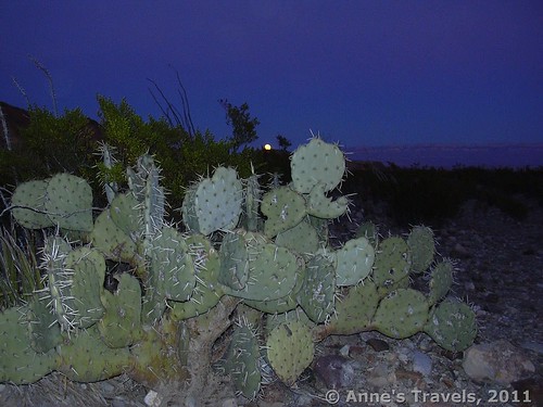
Moonrise in Big Bend
Backcountry Car Camping along main roads in Big Bend
Backcountry Car Camping along primitive roads in the south part of Big Bend
Backcountry Car Camping along primitive roads in the north/west parts of Big Bend
Signs 
![]()
Scenery
Would I go 100 miles out of my way for this?
Overall Rating: 
This Week’s Featured Product!
This little book offers 47 trails that can be hiked in Big Bend National Park. From short strolls to long dayhikes (or even overnight treks), this book is a very comprehensive overview of the trails in the park.


I am new to this, I stumbled upon this. It absolutely useful and it has aided me a lot. Good job.
Great blog, Anne; very interesting! A couple of comments about Big Bend…
Regarding overrated hikes… It’s still Big Bend, and most of those you mentioned would be tagged “can’t miss” in most other parks. Concerning the Windows Trail, I think the view is excellent for practically the entire return hike (make your return in the late afternoon) and that overall, in both directions, it’s a fine desert hike.
Best hikes… In my opinion, the very best is definitely the hike to the South Rim. The Falcon Guide you show above calls it the “classic” Texas hike. In fact, one of the greatest hikes I’ve ever taken anywhere.
And, here’s where we’ll disagree the most… If you can’t hike the South Rim, Lost Mine Trail is the best alternative. While there are not as many views, they are similar to those seen from the South Rim Trail (I hike it up Laguna Meadows, and down Pinnacles), and you’ll spend less time and energy to get them. Plus, if you spend a buck & pick up the trail guide, you’ll learn a lot about the Chihuahuan Desert.
Again, looks like you’ve got a great blog here. I’ve really enjoyed what I’ve seen so far, and I’m looking forward to exploring it further. Big Bend is probably my favorite place on earth, so I started here. Thanks for all of the time & effort you’ve obviously spent on this.
Hi Dick, Thanks for the comments, and glad you like the blog. It’s interesting to hear other hikers’ opinions, especially about hikes I didn’t really enjoy, like the Lost Mine Trail. I have to wonder if I’d like it more if I did it again…
Anne, nice blog and while I don’t agree with everything, I respect anyone willing to put the effort into sharing his/her experience with others.
As Dick says, the South Rim hike is phenomenal. I think it defines Big Bend. But I hesitate to call it a specific Trail, because it has so many great dimensions. As Dick says, Laguna Meadows and Pinnacles are great elements of the SRT. But missed altogether (it seems) is Boot Canyon, which is a gorgeous vista and such a fun hike for many reasons. But if you aren’t doing the South Rim, you have no cause to hit Boot Canyon really…but it’s so worth it.
The other trail I’d recommend (with hesitation because I don’t want it to get overcrowded!) is the Pine Canyon Trail. It gives you Desert + Forest.
Having just returned from Yosemite…the NPS Mecca…I am still extremely proud of our State’s National Park. It has totally earned it.
Thanks for the recommendations! I’ll have to check them out next time I’m in Big Bend…
Planning a day hike this month. Love the blog and now I’m having trouble choosing a hike. We have a 4 year old so that’s our limiting factor. Thought I wanted to do Emory Peak but now I’m considering the South Rim??? Decisions!!!
Hi Macci! Glad you like the blog. Emory Peak is shorter…South Rim is pretty long for a dayhike…but if you’re up to it, I’m sure you’ll enjoy the trail!
Anne
Nice read thanks for sharing. I visited Big Bend on a 1 day visit, a 4 day visit and going back soon for another 3 day visit. The place is beautiful and although I am not really a hiker type, I did do the Lost Mines Trail with my two sons in June 2013. We got up very early and hit the trail around 6am, being the first was the best as we encountered three black bear along the way, really made the trip exciting. The switchbacks were rough and I had spaghetti legs when at the top but it was a great view with a nice cool breeze.
We sat a while, ate our breakfast and then the crowds came, wow, tons of folks came up and going down was a traffic jam. Santa Elena is fun and easy and the way the rock formation is formed it kinda makes the water look like its running up hill imo. This time I do not know what we will hike but am glad I found this blog to help me decide. I was fortunate enough to snag Roosevelt Cabin 3 with a primo view down through the window.
Hi Jeff,
Congrats on the cabin!!! Glad you enjoyed the Lost Mine Trail; now I’m beginning to wonder if I did something wrong last time I hiked it 🙂 Another hiking idea I didn’t really mention in this post is Telephone Canyon – nice views of the cliffs over Boquillas Canyon. I haven’t hiked its entire length (yet!), but it seemed nice from what I was able to do before sunset.
Anne
Just got back this morning from a 4 day visit to Big Bend, weather was great. I took my two son and two nephews. We completed the Santa Elena, 3rd time still a great easy hike, views are outstanding. Mule Ears was nice, straight forward and the desert views were amazing. The chimneys were fun and easy, the boys had loads of fun climbing up and getting photos from the top of the chimneys. We did the window the first day and was nice but our timing was off as we went later in the day so it was hot and the climb back up was a real workout but otherwise a good hike. I wanted to try the South Rim but was out voted and the boys chose The Lost Mines.
I didnt mind as it had been 2 years and we left early at 6:30 am, first on the trail. We took our time, this proved to be great since I was not being ran up the mountain by the young whipper snappers. We stopped along the way and took it all in and this really turned out to be the jewel of the trip. About half way up looking back to the southwest the window and Mexico are easily visible. I had the trail guide and had the boys read about all the plants along the way. As we climbed we saw several beautiful birds, blue, yellow etc. Came across several deer and two foxes. The best was the mother bear and her three cubs as she was foraging for food as we quietly watched and photographed and kept our distance. We made it to the top and walked to the furthest point we could walk. We sat a good hour eating breakfast before other hikers appeared. The view to the east is breathtaking, wide open vistas and the cool morning breeze. I can not compare to the South Rim but I can recommend the hike. I am not a hiker but kept up with the boys and the trail only really gets tough/steep maybe the last 100 yards before coming out of the trees and the trip down is a breeze.
Oh Anne, FYI I had printed this blog out for the trip and made copies for the boys to read to help choose which hikes they wanted to go on. After they had made their decisions and our days were planned I ended up giving the copies away to other folks I talked to that were asking question about what to see, hikes etc. which turned out to help several others visiting. Thanks to you and your blog it sure helped when deciding which hikes to try…I could have easily stayed another week, Big Bend is an amazing place. Thanks, Jeff
Now I wonder if maybe they’ve cleared out the brush on the Lost Mine Trail or something…maybe I’ll have to give it a try next time I visit!
Anne
So glad you found the post useful! And what a great idea to print it out and let everyone read it, then to give it away! May have to try that myself on a future trip…
Pingback: Anne's Travels » Link Roundup: My Favorite Hiking Websites
Have you been to Ernst Tinaja? This is a beautiful little trail. I only found it by accident because my husband and I camped at the site just before the parking area.
Hi Aggie, I haven’t been to Ernst Tinaja; I’ll have to check it out! Anne
You sound like whiner to me. I’ve hiked the lost mine trail 3 time and yes it was crowded the last time. In the 1992 I ran into four bears on that trial one was s mother and two cubs. n
Bears – now that’s exciting. Glad it wasn’t me 🙂
Anne
Anne,
Thank you so much for recommending the Oak Springs trial to the Window. My wife and I hiked it yesterday, and it was fantastic. I never would have found the trail without your guidance. The views were great, and we did not see a single person on the trail until we reached the Window. This hike is now in my top 5 list of hikes in Big Bend. The Grapevine Hills and Santa Elena trails are also in my top 5.
You’re very welcome, Greg! So glad you enjoyed Oak Springs. Would have loved to have visited the waterfall, too, but ran out of time. Well, maybe if I have to take a winter vacation someday…
I agree the windows trail is over rated, although I wouldn’t call it strenuous. The view is limited once you reach the pour off. On the other hand I think Lost Mine trail is the best hike in park. There are two options for Lost Mine trail, first if you don’t want the long hike, the first mile is up and easy incline to the saddle a very nice view to the east and southeast. The rest of the hike gets steeper, but the views are great if you stop several times to look back to the west for views of Casa Grande, the Window & the basin area. I especially like to start the Lost Mine trail just at “civil twilight” in the morning (actually before that when you almost need a flashlight to see the trail) and watch the sun rise from the saddle area of the trail.
A trail I don’t think you mentioned is the Pine Canyon trail. I think this is a great hike. First you hike along an open area with nice views of the Chisos Mtns then through a grove of beautiful Texas Madrone and ending at a usually dry waterfall. This is probably my second favorite hike in the park.
Sounds like a great idea – I’d love to see the sunrise when I try out the Lost Mine Trail again…maybe I hiked the wrong trail? Seems everyone loves it!
Wow, sounds really cool! I’ll have to try that next time I’m in Big Bend!
Pingback: Anne's Travels » The Best of Anne's Travels in 2015
Pingback: Top 10 Pages on Anne’s Travels in 2014 - Anne's Travels
Anne,
Thanks for the tips!
I’m looking forward to my first visit to BBNP, and will definitely use your suggestions.
Great site!
John, You’re welcome! I hope you have a great trip!
Anne
The hikes are great, but you failed to mention that the night skies are almost without peer in the lower 48. The lack of light pollution and low humidity make for star gazing deluxe. Of course cloudless skies are required. Most will wish I think that they had more time than they allotted for their stay. Your rating system is sure to be of help to all new to the park. Too much to do and see and too little time get it all done.
Tom, The skies are truly amazing in Big Bend – only Death Valley rivals the clarity, I think. And the great thing is that it’s so dry you can sleep out on a tarp without fear of dew, so you can stargaze before going to sleep!
I enjoyed reading your descriptions. I would like to spend a day or two hiking in the park with my wife. While I recently climbed Kilimanjaro at age 57 and am considering the Annapurna Trail in Nepal, my wife is much weaker and gets worn out walking city streets after a few hours. Is there a hike or two that you’d recommend for her that would still spectacular for me? Thanks in advance.
That sounds like amazing things to do, John! For you and your wife, I would highly recommend Santa Elena Canyon and Grapevine Hills (both fairly short without tremendous elevation gain – note that the Grapevine Hills Trail is fairly sandy, which makes it more difficult to walk). Both have some unique scenery, too – Santa Elena has sheer canyon walls, while Grapevine Hills has the balancing rock arch. If you want one longer hike, I’d recommend the Oak Springs Trail because of the views of the Chisos and then down onto the plains during the hike (it’s longer, though, and has some elevation gain to get up to the Window – that said, you could make it shorter and have much less elevation gain by going to Cattail Falls (the waterfall that flows out of the Window), though this would also bypass the views out over the plains). If she’d simply rather not hike, check out the River Road (you can ask for current road conditions at the visitor center). It is extremely scenic and you could visit Mariscal Mine if you wanted to just stretch your legs. Hope that helps!
Pingback: Weekend Cruise and Hike on Big Bend National Park – WanderThemes