The Murphy Trail in Canyonlands National Park can be a little bit confusing – not because hiking it is all that difficult (it’s a trail and it’s pretty hard to get off of it), but because the name is actually used for two trails: The Murphy Point Trail and the Murphy Hogback Trail. They share a parking area and the first 0.4 miles of trail, but then they become two different entities altogether. Murphy Point is a fairly flat hike to the rim of Island in the Sky with fantastic views of the Green River, White Rim Road, and Canyonlands. The Murphy Hogback Trail steeply descends off of Island in the Sky, turns onto the White Rim Road near “Murphy’s Hogback”, and then returns back up to the rim via a slightly different route for part of the hike. This post is about Murphy Point, not the Murphy Hogback Trail (which I hear is very nice in its own right, but so far I haven’t had the opportunity to hike it).
Quick Stats
Note: Some of the links in this post are affiliate links. If you click one and purchase something, I may earn a small commission without an extra cost to you.

The trail begins in a small dirt parking area – I gather the parking area can be quite crowded on busy days. Hiking early is a good idea, anyway, since the views are better earlier than later in the day (though late enough that the light can get over Island in the Sky to the canyons below!) since the view is mostly west-facing.

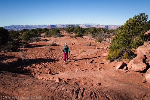
At first, the trail meanders across a grassy plain, passing by some old ranching relics. There isn’t much in the way of views in this section, though I enjoyed the desert meadow effect. At 0.4 miles, the trail forks. A sign points toward Murphy Point and the Murphy Trail to White Rim Road. Turn right, following the arrow toward Murphy Point.

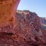
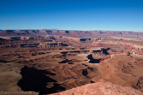
As the trail gently descends, views open up more and more to the Canyonlands. You can almost taste what it’s going to look like when you finally get there! Shortly before the end, the trail becomes rougher, descending slickrock and navigating around some rocks. It looks like this part of the trail was once a road.
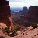
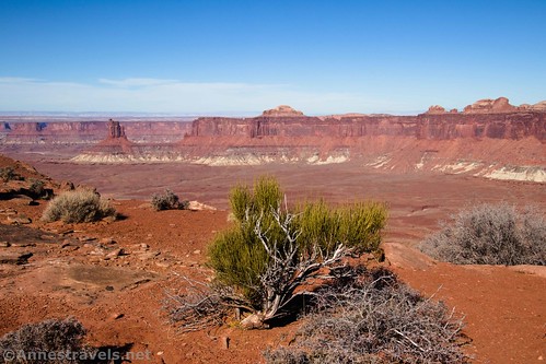
Keep your eyes open for a view out on the right – Candlestick Tower from this vantage point is pretty awesome!
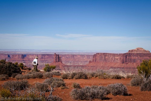
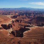
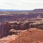
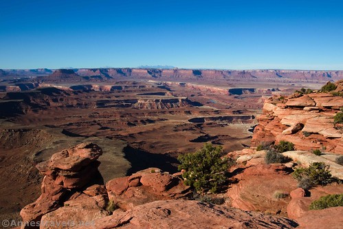
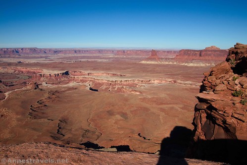
About 1.7 miles from the trailhead, the trail more or less disappears in a lot of slickrock and brush. From here, it’s pretty easy to scramble as close to the rim as you dare – there aren’t any guardrails. If people are congregated here, walk/scramble along the rim for a bit in either direction – there are fantastic views from many points along the rim!

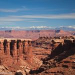
To the southeast is Grand View Point and Junction Butte; Murphy Hogback is very obviously due south (it’s just a stretch of butte that extends out further from the canyon wall than most others – the White Rim Road crosses the Hogback, and I hear it’s quite an infamous stretch of road). Beyond Murphy Hogback on the other side of the river is Ekker Butte with the Henry Mountains in the distance. To the northwest, Candlestick Tower is obvious; the canyon between you and Candlestick Tower is called Soda Springs Basin. The Green River winds through it all.
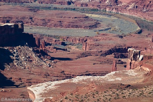
When you’ve picked your jaw up off of the ground at the incredible beauty of the area, be sure to look down at the White Rim Road. Chances are you’ll see vehicles on it – a telephoto lens or binoculars are useful for seeing the road and vehicles close-up.

Actually, a zoom lens or binoculars are useful just for exploring the canyons with your eyes. There’s so much to see here, from strange rock formations to the Green River to slickrock domes to canyons you might not be able to distinguish with the naked eye.
When you’ve finally had your fill of views, return to the Murphy Trailhead. It’s a short and sweet trail, but it packs a punch in terms of views!
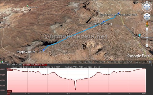
Round Trip Trail Length: 3.5 miles, not including scrambling along the rim
Elevation Gain: 343ft. (6,241ft. to 6,049ft.)
Facilities: None, not even a restroom or picnic table
Fees: $30/vehicle, valid 7 days. America the Beautiful National Park Passes and Southeast Utah Parks Passes are also accepted.
Trail Notes: Try to hike this one in the morning if you can – the views to the west (aka most of the views) will be better. This is not a great trail for children or for those with a fear of heights, since there are no guardrails and it is an exceedingly long way down. (That said, my group member who hates heights did just fine – and the trail doesn’t go to the edge, so you can just approach it as close as you want to.)

Trail 
![]()
![]()
Road ![]()
Signs ![]()
Scenery
Would I go 100 miles out of my way for this?
Overall Rating: ![]()
GPS Coordinates for Murphy Point
Murphy Point Trailhead: 38.3550333°, -109.8638167° (N38° 21.302′ W109° 51.829′ / 38°21’18.1200″, -109°51’49.7400″) (6,038ft.) (0.0)
Point vs. Hogback Junction: 38.3514167°, -109.8701333° (N38° 21.085′ W109° 52.208′ / 38°21’05.1000″, -109°52’12.4800″) (6,165ft.) (0.44)
Murphy Point: 38.3421333°, -109.8890333° (N38° 20.528′ W109° 53.342′ / 38°20’31.6800″, -109°53’20.5200″) (6,049ft.) (1.71)
End: 38.3549500°, -109.8639667° (N38° 21.297′ W109° 51.838′ / 38°21’17.8200″, -109°51’50.2800″) (6,209ft.) (3.48)

The gpx file for the Murphy Point Trail can be downloaded – please note that this and the GPS Coordinates are for reference only and should not be used as a sole resource when hiking this trail.
Download GPX File size: 41.2 KB Downloaded 396 times
(Note: I do my best to ensure that all downloads, the webpage, etc. are virus-free and accurate; however, I cannot be held responsible for any damage that might result, including but not limited to loss of data, damages to hardware, harm to users, from use of files, information, etc. from this website. Thanks!)

Getting to the Murphy Trailhead
From the Island in the Sky Visitor Center, head south 8.7 miles to the Murphy Trailhead, on the right, staying left when the road to Upheaval Dome turns right. The dirt parking lot can be easy to miss, but it’s obvious once you’re there.
This Week’s Featured Product!
For even more hikes in Canyonlands National Park, check out this Falcon Guide to Canyonlands and Arches National Parks – the book covers just about every easily accessible hike in Canyonlands, so you won’t be disappointed.