If you can only visit one overlook for close-to-sunset in Island of the Sky District of Canyonlands National Park, I’ll give you two choices: 1) Grand View Overlook, and 2) White Rim Overlook. Both offer fantastic views of the eastern Canyonlands and Monument Basin, and to be honest, while they’re very different, they offer a similar enough view that it’s hard for me to decide which one I like better. But since Grand View is so popular, White Rim might be a slight preference since it offers a chance at a little more peace and quiet.
Quick Stats
Note: Some of the links in this post are affiliate links. If you click one and purchase something, I may earn a small commission without an extra cost to you.

I started my hike in the not quite mid-afternoon on a weekday in November. Snow and cold temperatures had driven most of the crowds out of Moab a couple of weeks earlier, so the entire area was pretty quiet. There are less than a dozen or so parking spaces at the trailhead and picnic area combined, so come early in regular seasons. That’s a hard one to say since the White Rim Overlook is best in the last few hours before sunset.
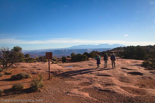
Actually, the Gooseberry Trail (post coming soon!) and the White Rim Overlook share the same trail for the first few hundred feet. Then the Gooseberry Trail turns left to scramble up some slickrock and plunge over the edge into relative oblivion, while the White Rim Overlook Trail goes right to stay on the mesa top. Most of the parking spaces are taken by those hiking the Gooseberry Trail, so they should be finished and leaving about the time you’re looking to hike to the White Rim Overlook for sunset.
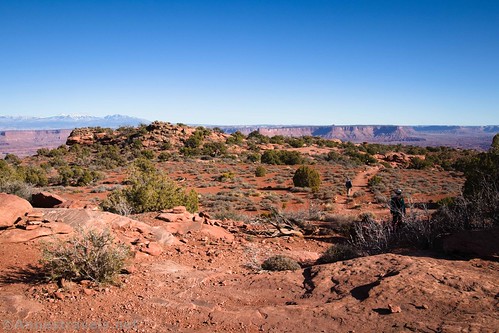
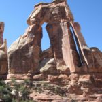
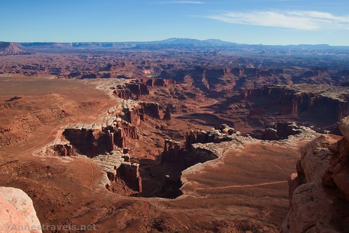
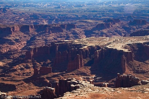
The trail is fairly non-descript; typical sand-and-slickrock-follow-the-cairns tread with peek-a-boo views toward the Canyonlands. Just before the end of the trail, the views open up tremendously down on Monument Basin (to the right). On the left is a large rock formation with a little arch.

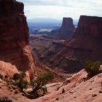
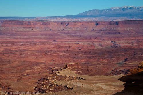
Keep walking down the narrow path to the actual viewpoint. There are no railings, and you’re out on a fin in the canyon, so there are some serious drop-offs!
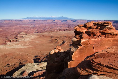
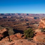
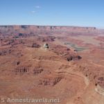
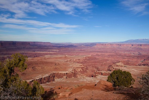
The views from here are spectacular. Monument Basin is the first thing that catches your eye – all of those rock formations!

But the La Sal Mountains are also fantastic!

Then there are the views of Gooseberry Canyon…

And the White Rim Road…

The Potash settling basins…

Off in the distance, you can even see the Needles!

So many amazing views!
When you’ve finally had your fill of views (or when the sun goes down!) retrace your steps to the parking area. It’s a short and sweet trail, but it’s so worth it to see the views!

Round Trip Trail Length: 1.9 miles out & back
Elevation Gain: 528ft. (6,275ft. to 6,105ft.)
Facilities: One-seater primitive restroom in the picnic area; picnic tables
Fees: $30/vehicle, valid 7 days. America the Beautiful National Park & Federal Lands Passes and Southeast Utah Parks Pass are also accepted

Trail Notes: There are no railings. I never felt in danger, but this might not be the best hike for young children. The views are best in the few hours before sunset – too close to sunset and Monument Basin will be too shadowed for good photos, but the La Sals will be great all the way until dark (not that I recommend hiking back in the dark!)
Trail 
![]()
![]()
Road ![]()
Signs ![]()
Scenery
Would I go 100 miles out of my way for this?
Overall Rating: ![]()

GPS Coordinates for the White Rim Overlook
White Rim/Gooseberry Trailhead: 38.3228500°, -109.8494667° (N38° 19.371′ W109° 50.968′ / 38°19’22.2600″, -109°50’58.0800″) (6,271ft.) (0.0)
White Rim/Gooseberry Trail Junction: N38° 19.382′ W109° 50.903′ (6,226ft.) (300ft.)
White Rim Overlook: 38.3200000°, -109.8352667° (N38° 19.200′ W109° 50.116′ / 38°19’12.0000″, -109°50’06.9600″) (6,102ft.) (0.95)
End: 38.3228333°, -109.8494833° (N38° 19.370′ W109° 50.969′ / 38°19’22.2000″, -109°50’58.1400″) (6,232ft.) (1.86)
The gpx file for the White Rim Overlook can be downloaded – please note that this and the GPS Coordinates are for reference only and should not be used as a sole resource when hiking this trail.
Download GPX File size: 32.9 KB Downloaded 370 times
(Note: I do my best to ensure that all downloads, the webpage, etc. are virus-free and accurate; however, I cannot be held responsible for any damage that might result, including but not limited to loss of data, damages to hardware, harm to users, from use of files, information, etc. from this website. Thanks!)

Getting to the White Rim Overlook Trailhead
From the Island in the Sky Visitor Center, drive south on the main road. Continue straight toward Grand View Overlook when the road to Green River Overlook, the Campground, Upheaval Dome, etc., goes off on the right. About 11.3 miles south of the visitor center, turn left, following the sign for the picnic area and restrooms. Halfway around the one-way loop, there will be half a dozen or so parking spaces on the right next to the trailhead.

This Week’s Featured Product!
Check out this book for more trails in Canyonlands and Arches National Parks. The authors have been hiking for decades, with a major emphasis on adventure. Enjoy the photos and trail descriptions within the book even before you go hike the trail.