

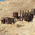
On our last visit to Death Valley National Park, the Keane Wonder Mine Trail was high on my list of “must-do” hikes. I’d hiked it at least three times back in the early 2000s, but then the area was closed for hazardous waste cleanup. As much as I was thankful not to be breathing cyanide dust (and I wondered just how much worse it was when they started cleanup vs. when I’d last hiked it), I also wondered what changes had happened to the trail. There were rumors of a rerouted trail and stabilization of structures, so I put on my hiking boots and we started up the trail not so very early on a bright and sunshiny morning in mid-November.
Quick Stats
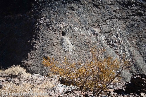
Actually, all was not warm sunshine and Death Valley’s classic heat. A cold front had come through the night before, and the wind was still fierce. The trail itself is quite exposed, so even the warm sunshine couldn’t compete with chilly air and gale-force winds. We just about froze!

The trail begins with a sign warning you of the dangers of the trail. Read them, agree to your conscience that you’ll stay on the trail, and head up. It’s pretty steep from the first.

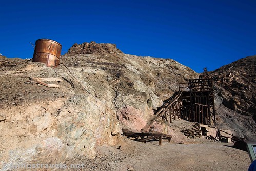
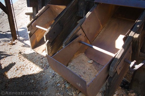
The Mill Site is only 0.2 miles up the trail. Signs talk about the Keane Wonder Mine’s history. This was where the stamp mill processed the ore before it was taken to Rhyolite to be made into gold bars. A cyanide processing plant was once nearby, just down the hill; the chemicals were used to extract gold from the tailings left over from processing the initial ore.
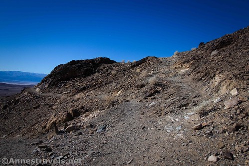
Most people don’t go much further than the mine site. I can’t blame them; the trail is a crazy one. I’d guess it was the old road up to the mine, and apparently vehicles of that day didn’t mind insanely steep grades.
But if you want to continue, go back to where you turned to go down to the mine site and take the right-most main trail that won’t take you back down to the Mill Site. There is another main trail that goes off just to the left of the trail back down to the parking area. This left trail is fairly level and goes off around the rib of the hill. It ends, eventually, at some other ruined buildings, and while interesting, it doesn’t take you up the Keane Wonder Mine Trail. In fact, if your trail isn’t fairly wide and very steep, you’re probably on the wrong trail. You’ll also be more or less following a pipeline up the mountainside.

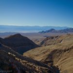
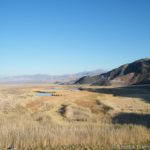
Keep walking upward. Views become excellent down onto the northern part of Death Valley and across to the mountains on the western side.
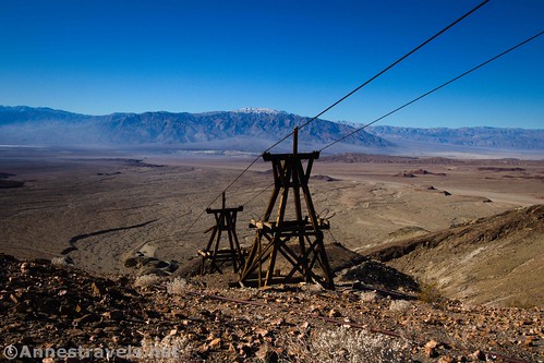
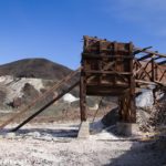
At about mile 0.6, the trail comes up to a couple of the thirteen towers from the aerial tramway. These are very cool to see, and it’s another turn-around point for many people. But the trail after this moderates a bit, which is a good thing – it’s hard to keep going up a trail that steep!

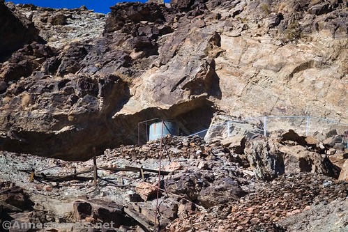
The next interesting feature is a wooden door set into the cliff on the left of the trail about mile 1.3. This is a mine entrance. I have no idea why the wooden door was necessary. And while I’ve found it workable, blocked open, and blocked shut on various treks up the trail, this time the door is official and you can go a short distance into the mine! The shaft is barred off after a few feet, but it’s pretty cool to be inside a real gold mine.

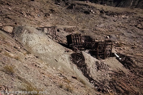
Keep hiking upward. You’re mostly just walking along the side of the hill here, so while there is a grade, it’s nothing like the first part of the trail. About 0.15 miles after the mine with the door, you’ll pass a little rib of rock that protrudes out into the canyon. You can see where people walk out on it to get pictures of the aerial tramway. If you follow the vague social trails down below the rib of rock and slightly to the left, you’ll come to the break over station that helped the ore buckets reach an especially long distance between towers.

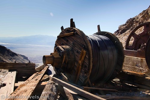
Keep walking upward the last stretch to the top of the aerial tramway at about mile 1.8. A mine is nearby to the left and the top of the tramway is to the right. A path to the left of the mine leads up to spools of wire – I don’t know exactly what these were used for, but they’re pretty interesting to see.
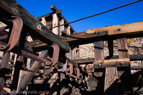
There is no apparent official trail down to the top of the aerial tramway, but if you walk a good distance to the right, you can safely descend a social path (don’t try going straight down, since it’s very steep). Once down at the terminal, you can inspect what’s left of it – including ore buckets and gears and whatnot. Each bucket could carry 600lb. of ore. They were loaded automatically, and the weight of the full buckets coming down the hill was enough force to bring the empty buckets back up without using electricity.

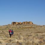
From here, I continued up the old road/trail as it wound east around the hill and then north. I only went about a tenth of a mile, but I found an old wheelbarrow, some old ruins, a few mine shafts, and other historical junk. I don’t necessarily recommend coming up here, and if you do, be sure not to trespass behind the fences that keep people out of the Keane Wonder Mine. The mine itself is very unstable and you should never go inside of it or any other mine in the area unless the park service specifically says it is safe to do so.
Retrace your steps back down to the parking area. The hike isn’t long, but it is steep. But given the historical stuff you get to see along the way, I highly recommend it!

And what about the differences from the early 2000s? The buildings are definitely in better condition, the road has changed course, and some areas feel a bit less “natural.” But in general, the park service has done an excellent job of restoring and making the trail safer without damaging the historic appeal.

*A couple of random facts: It’s estimated the Keane Wonder Mine produced $1,100,000 worth of gold ore (that would be close to $24 million today). The biggest single production month was the month after the cyanide plant began production – Homer Wilson (who owned the mine at that time) brought in a gold bar worth $25,000. Up to that point, it was the largest single-month output of any mine in the area.

Round Trip Trail Length: I ended at 4.0 miles, so without going the extra 0.25 miles RT beyond the main mine area, that would be 3.75 miles
Elevation Gain: 1,926ft. (1,324ft. to 2,867ft.)
Facilities: None. The closest restrooms are up at Daylight Pass Junction.
Fees: $30/vehicle, valid 7 days. Death Valley Annual and National Park Passes also accepted.
Trail Notes: The trail is very exposed. Do not attempt this during hot weather. Even during warm weather, you probably want to do it in the early morning, before it gets hot. Don’t go off-trail, as there are multiple mine hazards and milling hazards (cyanide, anyone?) in the area.

Trail 
![]()
![]()
Road ![]()
Signs ![]()
Scenery
Would I go 100 miles out of my way for this?
Overall Rating: ![]()
GPS Coordinates for the Keane Wonder Mine Trail
Keane Wonder Trailhead: 36.6680000°, -116.9104500° (N36° 40.080′ W116° 54.627′ / 36°40’04.8000″, -116°54’37.6200″) (1,340ft.) (0.0)
Mill Site: 36.6694167°, -116.9089500° (N36° 40.165′ W116° 54.537′ / 36°40’09.9000″, -116°54’32.2200″) (1,411ft.) (0.17)
Towers: 36.6713500°, -116.9078000° (N36° 40.281′ W116° 54.468′ / 36°40’16.8600″, -116°54’28.0800″) (1,743ft.) (0.62)
Mine with door: 36.6781333°, -116.9061667° (N36° 40.688′ W116° 54.370′ / 36°40’41.2800″, -116°54’22.2000″) (2,423ft.) (1.33)
Keane Wonder: 36.6815167°, -116.9013167° (N36° 40.891′ W116° 54.079′ / 36°40’53.4600″, -116°54’04.7400″) (2,704ft.) (1.78)
Mine area: 36.6822667°, -116.9012667° (N36° 40.936′ W116° 54.076′ / 36°40’56.1600″, -116°54’04.5600″) (2,844ft.) (2.21)
End: 36.6680333°, -116.9104667° (N36° 40.082′ W116° 54.628′ / 36°40’04.9200″, -116°54’37.6800″) (1,307ft.) (4.04)

The gpx file for the Keane Wonder Mine Trail can be downloaded – please note that this and the GPS Coordinates are for reference only and should not be used as a sole resource when hiking this trail.
Download GPX File size: 111.3 KB Downloaded 359 times
(Note: I do my best to ensure that all downloads, the webpage, etc. are virus-free and accurate; however, I cannot be held responsible for any damage that might result, including but not limited to loss of data, damages to hardware, harm to users, from use of files, information, etc. from this website. Thanks!)
Getting to the Keane Wonder Mine Trailhead
From the Furnace Creek Visitor Center, turn left onto CA-190W. After 10.6 miles, turn right onto the road marked for Beatty. Drive 5.7 miles and turn right onto the well-graded dirt road to Keane Wonder. Park at the end of the road, 2.8 miles later.
The turnoff on the dirt road is 4.3 miles south of Daylight Pass Junction, where the Beatty Road meets the Daylight Pass Road at an information station with a kiosk and restrooms.

Note that the road to the Keane Wonder Mine is gravel. While it is usually accessible to low-clearance vehicles, floods may temporarily close the road or make it high clearance only.

This Week’s Featured Product!
Looking for even more hikes in Death Valley? This one suggests almost 60 trails in the park.

Pingback: Trip Overview: Death Valley and Beyond - Anne's Travels