


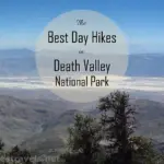
In the far south-east part of Death Valley National Park is a dirt road. That’s no big surprise, as there are lots of dirt roads in this section of the park, but on this particular dirt road is another dirt road that leads to a very interesting and totally overlooked section of the park. Here at Saratoga Springs you can see a view that looks almost like the African Serengeti: and you don’t even have to hike far to get to it! However, if you like hiking, awesome views and old mining structures await you as you hike farther down an old mining road. For an updated post with more photos and GPS coordintes, click here.
(Affiliate links are present on this page.)
To get to Saratoga Springs, from Baker, CA drive north on CA-127 for about 35 miles. Just before you enter Death Valley National Park, there will be a dirt road on your left. Take this dirt road. If you’re coming from the north, from the town of Shoshone, take CA-127 south for approximately 22 miles until you leave Death Valley National Park. At this point you will see a dirt road on your right; this is the road you want. If you want to come from the main part of Death Valley National Park (Badwater area), take the Badwater Road over to CA-127, then drive south for 24 miles to the dirt road on your right (you will go through the town of Shoshone). Or, you can take the Harry Wade Road (if you have 4×4 and don’t mind turning around if the road is flooded) from the Badwater Road and come in from the other direction. My directions will be from CA-127. After you turn onto the dirt road, drive 6 miles. The road is gravel, and in fairly good condition (at least when we were there). A 2-wheel-drive, low-clearance vehicle could have made it down this road. After 6 miles, there will be a sign pointing towards Saratoga Springs up a dirt road on your right. If you are coming from the Harry Wade Road, there is no sign in your direction; you will have to look back to see the sign pointing down the dirt road. This road, although the park service classifies it as “high clearance recommended”, may not be passable without 4×4. We ran into a huge puddle across the road, and nearly didn’t make it through on our way back: we were out pushing our high-clearance, two-wheel-drive van, and even then, almost didn’t get out! Anyway, it’s 4 miles from the turn-off to the parking area for Saratoga Springs. I believe that on the way you will pass another dirt road leading to Ibex Dunes on your right (the junction is marked).

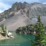
You will know that you are in the parking area for Saratoga Springs when there is a blockade across the road. Park in the wide space in the road just before the blockade, and walk up on top of the blockade. From the top of here you will get a terrific view of the springs and grass that make up Saratoga Springs. I liked the view best in the morning, especially in the very early morning light, although too early the springs would be in the shadow of the hills nearby. It really has a quality like pictures I’ve seen of the African Serengeti, with grass waving in the wind in a very arid place. You almost expect to see a giraffe or zebra suddenly appear! The bird watching here would probably be pretty good, although I don’t recall seeing very many birds when were there a couple hours have sunrise. However, there was some wildlife, including several species of fish in the springs. Near here there are also ruins of some small cabins. It is not a long walk to these; just a little way down the old mining road from the top of the blockade.

From the top of the blockade you can see the remains of an old mining road going along the base of the hills to your right. It may look like just a trail at the moment, but it is actually a very nice hike if you have the time. Climb down the blockade and follow the trail/road as it skirts the springs and climbs up to go over a small hill. At the other side of the hill, the road suddenly drops off into nothing, but you can climb down to the wash below and walk down the wash and around the next hill. Alternatively, you can take a small trail around the hill instead of up the road, across the wash, and around the next hill. This will avoid the climbing and scrambling required if you follow the road. I think we scrambled down the road, then walked down the wash to the trail around the hills.

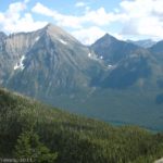
From here, you can follow the trail/road for a very long way. I don’t know how far, but it is a very pretty, flat hike along the base of low hills. You are walking next to a small mountain range on one side and on the other side is the beginning of Death Valley. You can look across this valley and see other mountain ranges (including Telescope Peak) on the other side of the valley, which is really beautiful. In December, these mountains had snow on them, which makes them even more pretty. On the other hand, the part of the hike we enjoyed most was climbing up the washes into the hills themselves to look at some old mines and mining equipment. Please use caution in these areas, as you never know what might have been left behind by the miners. Also, there are open mine shafts (as well as several that have been closed up by bulldozers), so be aware of where you place your feet. Please also tread carefully, and leave what you find here for future visitors.

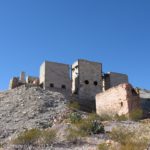
The first mining area that you will come to is on the right side of the trail up in a small valley in the hills. It is the best and most interesting of the ones we visited. This operation has a wooden ore loader that was used to load or sort or bring up ore out of the mines. A mine shaft is nearby, but it has been filled in by a bulldozer. We hypothesized that it was once a uranium mine, and that there was too much uranium left in the mine for it to be left open. However, I’ve since read that it was a talc mine. Who knows—they might have just been trying to keep visitors safe. A side trail leads along the side of a cliff to a small metal box set into the side of the hill. We couldn’t figure out what it was until I suddenly cried, “Hey—I’ll bet it’s a dynamite shack!” Whether it is or not, we’re not sure, but it seems quite likely! If you keep following the trail around the dynamite shack it will take you to a very nice view point. There is also quite a bit of junk left over from the days that the mine was in operation in this area.

As you continue along the main trail/road you will come to several other mining operations, some of which have ore loaders, and one which has a pulley system to pull ore out of the ground. We didn’t explore these as much in depth, although we could have spent hours more in the area and probably not have seen it all. We also wished we could have walked a bit farther on the trail/road, but we hadn’t brought enough food with us, so we had to turn around (after all, when we started down the road we thought we were only walking a little way to see where it went—we didn’t know what were going to find!). I’d guess we walked 3-4 miles on the trail/road before turning around.
Return by the way you came. Saratoga Springs is the perfect place to go if you want to see birds, wildlife that lives in and near the springs, mining equipment, pretty views, or just to find some peace and quiet: it’s not a well-visited part of the park: yet.

Fees: $20 to enter Death Valley National Park, valid 7 days. Interagency, Golden Age (Senior), Golden Access (Access), and Death Valley Annual Passes also accepted.
Trail 
![]()
![]()
Road ![]()
![]()
Signs ![]()
![]()
![]()
Scenery
Overall Rating: 
![]()
This Week’s Featured Product!
Find not only history in this book, but also many remote trails in Death Valley National Park.


2 responses to “The Serengeti in the US: Saratoga Springs”
[…] Saratoga Springs, Death Valley National Park, CA […]
[…] many times did we forget lunch before we learned our lesson? (I’m still waiting to go back to Saratoga Springs and actually bring lunch this time!) And how many hikes did we run out of water before contriving […]