
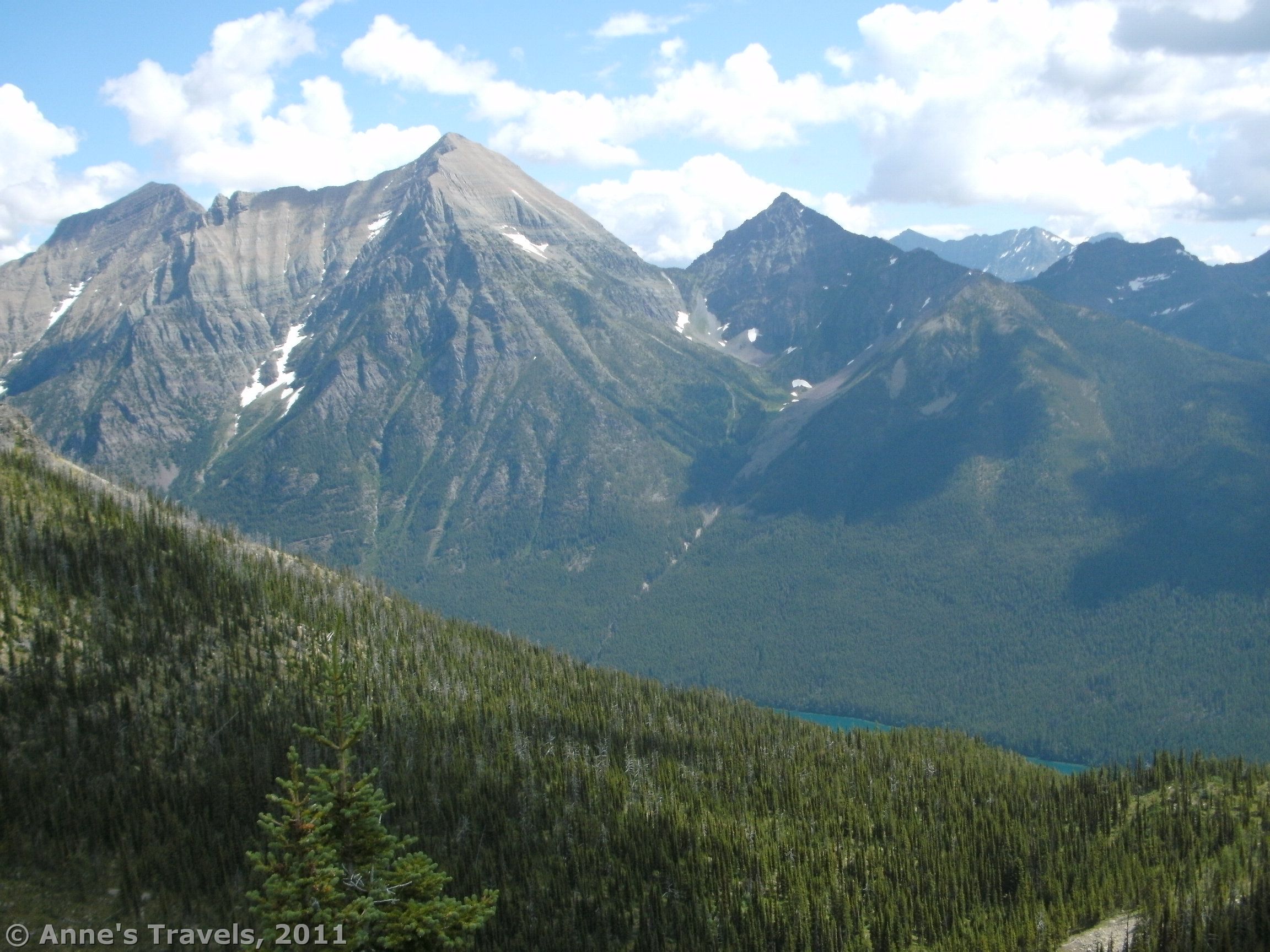

Glacier National Park has always been synonymous in my mind with rain. From my experience, “Partly Cloudy” means “Pouring Rain All Day”. However, on our last trip to the park, Glacier redeemed itself: although it did rain two of the three days we were there, it never downpoured, and we never got soaked while trying to hike. One hike we took—when it didn’t even sprinkle—was to Numa Lookout, a fire lookout with a terrific and pretty view of the surrounding mountains and Bowman Lake, a beautiful lake surrounded by snow-studded mountains. Although the view is gorgeous, I have one complaint: the trail is long (5.7 miles one way), and there aren’t very many views along the way. In other words, you’re hiking a long, steep trail with views only from the top. It’s still worth doing, but realize what you’re getting yourself into. Also, in the summer of 2011 we met the nicest young lady “manning” the lookout for the summer and fall. She invited us into her lookout, and explained how she finds fires and what she does in her job. That was fascinating, and in itself made the hike worth it!
(Affiliate links are present on this page.)
The trail begins at the southwestern end of Bowman Lake near the boat launch. However, you will need to park in the wilderness parking area 0.1 mile or so away from there. To get to Bowman Lake, take the Going to the Sun Highway north from West Glacier for two miles to the Apgar area. However, instead of turning right towards the Going to the Sun Highway, turn left towards Apgar and the Fish Creek Area. Don’t actually turn into these areas, however; keep going straight towards the Camus Creek Entrance Station. This section of road is 11 miles long. After the entrance station you will need to turn right on the dirt road leading north towards Polebridge, 13 miles away. At Polebridge, turn right onto another dirt road. The signs in this area are a bit confusing; follow the big sign for Polebridge. Drive 1 mile up to the Polebridge Entrance Station. Here you will need to show that you have paid your entrance fee, and you can get information about the road ahead (at least in the summer—we came in around 9:30 on a Friday morning). All of these roads, when we traveled them in early August, were easily passable by a low-clearance vehicle.

From the entrance station, turn left towards Bowman Lake and Kintla Lake. Only 0.3 miles later, turn right onto the road up to Bowman Lake. This road, although only 6 miles long, is very curvy and very bumpy. It is can be transversed in a low-clearance vehicle (we followed a Nissan Altima up the road), but be aware that vehicles drive quickly on the road, and you can’t see around the many blind curves. We never came close to having an accident, but be on the lookout for other vehicles. At last you will arrive in the Bowman Area. This is a very confusing place; follow the signs for the picnic area, then take a quick left into the Backcountry Parking Area (to the left of the restroom) instead. This parking lot fills up quickly: on a Friday morning around 10am, there were no more parking spaces. We parked in a non-existent spot next to the restroom, but latecomers had to park in the picnic area instead. I don’t think the park people mind…

From the parking area, a trail leads down towards the lake. This trail will take you down to the boat ramp. From there, head over towards the sign board, and the trail beyond. Signs in this area will tell you which way to go. You are trying to get to Numa Lookout. You will skirt the lakeshore for almost a mile, then head off on another trail (the junction is signed) uphill towards the lookout.
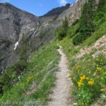
The lakeshore trail is fairly flat, with nice peek-a-boo views of the lake. Go fast while you can; the trail after this is not quite so easy! The trail to the lookout itself, about a mile from the boat ramp, immediately begins to climb, and then relentlessly continues to go up and up and up. There is one section of downhill not too long after you begin climbing, but other than that it is almost entirely uphill. The trail itself is not hiked very much (except by the person who mans the fire lookout, and the supply mule team who comes up every couple weeks). So, the trail, although easy to follow, is quite bushy and grown in. I highly recommend you wear pants in this section, although several members of my group were in shorts and seemed happy enough. The trail is definitely single-file only, and the first person found that they were getting quite wet from the dew on the bushes. I’m not trying to discourage you from hiking it, but realize what condition it’s in.

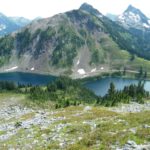
As you ascend higher and higher, you will eventually come to a place where there are fewer bushes and more trees around you. As you keep climbing, you will begin to be able to see peek-a-boo views of the lake and surrounding mountains. I found these views much better on the way down, for some reason, then on the way up. You will come up one huge switchback, hike for quite a ways further, and then start ascending several smaller switchbacks. This means that you are almost to the top. Don’t give up now! Once you are on the smaller switchbacks there will be more and more views of the mountains and Bowman Lake. Finally, you will come out on top of the mountain with the fire lookout right in front of you.

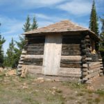
It was at this point that we were hailed by Francis, the young lady who is watching from the lookout this summer (2011). She invited us up onto the deck of the lookout, and the view from up here is much nicer than on the ground. You can see in every direction, from the southwest end of Glacier National Park into the national forest to the west and then to the mountain peaks on the other sides. You can even see into Canada to the northwest! We talked about her job and how she spots fires and what she does when someone else sees a fire. She communicates with several other fire stations via a walkie-talkie-like radio. Actually, while we were there someone called in to say they’d seen one, and that a fire truck was en route to put it out. After a while, Francis invited us into the lookout, so we got to see what it was like inside. She has a propane powered stove, refrigerator, and lights, so she can live fairly comfortably while she’s off duty (her hours are 9am-5:30pm, approximately). The whole experience was fascinating.

Afterwards, we walked over behind the lookout to the heliport (a place where it looks like a bunch of rocks have been piled up along what looks like a trail). It’s amazing to me that a helicopter could land on something so small!
Return by the way you came. Now it’s all downhill! After we got back, we took a quick swim in the lake…so nice after a long hike! 🙂
Round Trip Trail Length: 11.5 miles
Maps: A topo map of the area can be found at http://www.ouachitamaps.com/picture_library/Glacier/Glacier%20Bowman%20Map.jpg
Fees: $25 entrance fee to Glacier National Park, good 7 days. Interagency, Golden Age (Senior), and Golden Access (Access) Passes are also accepted.
Trail 
![]()
![]()
Road ![]()
Signs ![]()
Scenery
Would I go 100 miles out of my way for this? ![]()
Overall Rating: ![]()
This Week’s Featured Product!
This guide takes you to 40 of the very best hikes in Glacier National Park!


2 responses to “Good Views and a Fire Lookout, Too at Numa Lookout”
[…] Numa Peak in Glacier National Park, […]
[…] Bowman Lake in Glacier National Park, Montana […]