

I’m pretty much convinced that the Swiftcurrent Pass Trail to Swiftcurrent Peak is one of the most, if not the most, spectacular hike in Glacier National Park. (And yes, it might very well beat out the Highline Trail – at least in my mind!) The path wanders on a nearly level trail past three lakes and a beautiful waterfall, not to mention towering mountains, then up a rocky cirque in the shadow of tumbling cascades and the Swiftcurrent Glacier. If that wasn’t enough, the trail proceeds past views down on the Many Glacier Valley to Swiftcurrent Pass, then up the Swiftcurrent Peak Trail to views across most of Glacier National Park. There’s also a real fire lookout atop Swiftcurrent Peak.
Quick Stats
(Affiliate links are present on this page.)

There’s only one big problem: To get up to the peak and back is 17.6 miles without a chance to backpack (you’d have to come up from the Granite Park Chalet & Campground if you want to do this as an overnighter). So you’ll sort of have to walk the trail as a day hike. And 17 miles is pretty long. I did do it, so it’s possible. But that day I also completed 100 miles in 12 days, so I was in pretty good physical condition, and I was more or less acclimated to Glacier’s elevation. The people with me were also in excellent physical condition (one was also completing his 100th mile that day), but half the group decided 8.6 miles was enough and let the rest of us go on to the lookout while they stayed in the Swiftcurrent Amphitheater for a bit longer.
Last week, I wrote about the Swiftcurrent Pass Trail from the trailhead to the Swiftcurrent Amphitheater, where the trail takes a dramatic shift to start climbing up to the pass. Going to the Swiftcurrent Amphitheater is a worthy destination in its own right, but if you want even more views, you’ll need to keep walking up the trail.
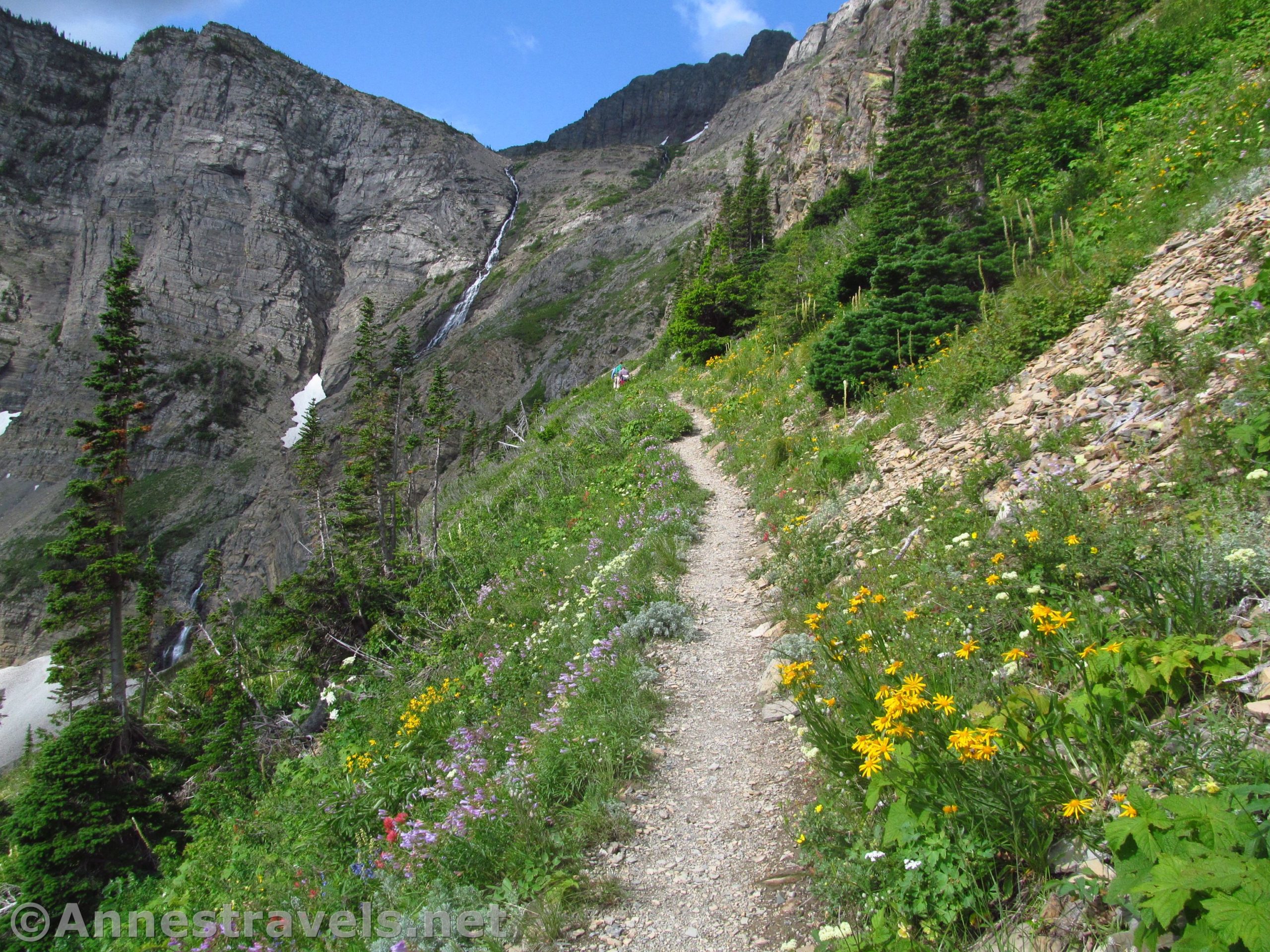
From the bridge in the Swiftcurrent Amphitheater, the trail begins switchbacking relentlessly. Since the trail has been mostly flat or slightly inclined to this point, the switchbacks are a bit of a jar to the legs and lungs. But the views – oh, the views!

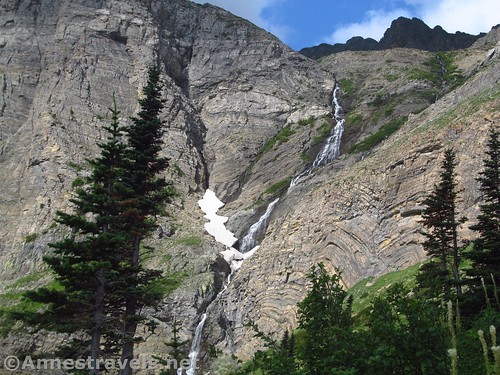
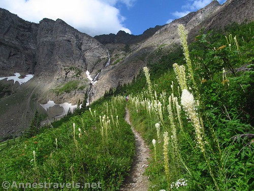
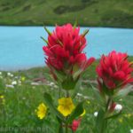
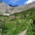
Waterfalls tumble down the sides of the Amphitheater, the craggy peaks rise high above. The Swiftcurrent Glacier rests on the other side of the valley, and the wildflowers in July were beyond belief. If I had thought the trail beautiful to this point, I was totally overwhelmed by this kind of spectacular.

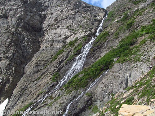
The views get better and better for the next 0.7 miles to the base of an unnamed waterfall (I’ll call it Swiftcurrent Falls, because, why not?)
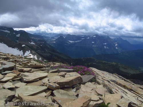
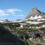
From here, the trail turns up to work its way around a curve cut straight out of the rocky wall (rather scary, really) to enter the next valley over. The views from here down on the Many Glacier Valley are spectacular. Unfortunately, the skies were clouding over, so my photos aren’t the best.

After the curve, the trail works its way across the valley, crosses a stream (fairly easy rock-hop), and then begins ascending up into Swiftcurrent Pass. By now, the clouds were overcasting the sky, and it looked rather stormy.

To me, Swiftcurrent Pass, 7.4 miles from the trailhead, was a bit of a disappointment. The Pass is a wide expanse of flatter land, dusted with trees and shrubs. There really isn’t much in the way of views (except for a view views of Heavens Peak if you go far enough across the pass), although there are the remains of the rock arch that once held a locomotive bell (donated to a scrap drive during WWII).

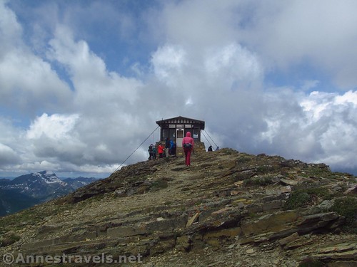
We were so disappointed, in fact, that when we arrived at the Swiftcurrent Lookout Junction at mile 7.5, it was a no-brainer to turn right up to the lookout. The trail itself is well-worn but extremely steep; you’ll be switchbacking upward the entire way, gaining 1,250ft. in 1.5 miles.

By now the wind was whipping with extreme force – so hard one gust almost blew me off my feet – and it was very cold. We were thankful for every layer we hadn’t left at the van, and wished that we had thought to bring another layer or two! But the views – oh, the views – became more impressive with every turn of the trail. I can’t imagine what it would be like on a clear day; with the storms blowing through the valleys below and most of the mountains in the shadow of clouds, it was still spectacular.

Across Swiftcurrent Pass, the clouds swirled constantly around Mount Grinnell, causing my hiking companions to rename it “Mount Head-in-the-Clouds”. Even the next day on the Highline Trail, it lived up to its dubious, if well-earned, name.

By the time we arrived at the fire lookout, we were warm from hiking, windblown, and ready for lunch. But first, we walked behind the lookout for some incredible views.
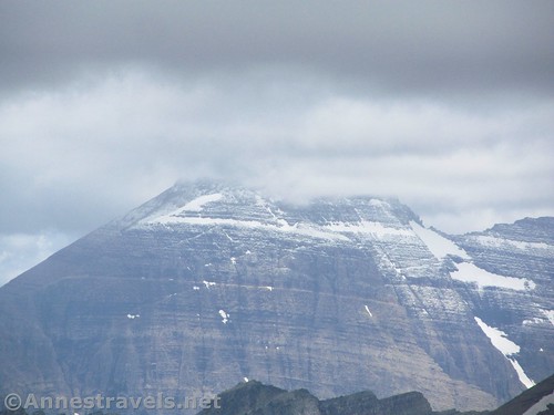
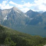
There are basically four different types of views from the Swiftcurrent Lookout: Northeast, the views major on striking rock ridgelines and peaks (take a look down into the valley – yikes!) To the north and northwest, the views are of more distant peaks, some in the US and some in Canada, many still snow-covered in July. Or maybe they had just seen the storm that hit us later and were covered in fresh snow.

To the west and slightly southwest, the mountains look more like hills, except for the beautiful Heavens Peak. To the south-ish-southwest, the mountains around Logan Pass are outstandingly beautiful. Mount Grinnell dominates the view to the south/southeast. And if you look down the Many Glacier valley, you can see the plains of Montana beyond. So you really have to keep turning around to catch all the views.

We took photos, we chatted with the fire lookout attendant (very friendly), and finally settled down to eat lunch. The wind continued to roar across the mountain, and our teeth chattered as numb fingers fumbled with the icy-cold peanut butter knife. But we were starving, and there wasn’t going to be a better place to eat until we got back to Swiftcurrent Pass. Here, at least, we were more or less in the lee of the fire tower.
From our lunchspot, we watched the storms fly across the valley below us, coming closer and closer. It wasn’t thunder and lightning (if that had been the case, I expect we would have spent a short while in the lookout!), but it was rain or hail or something like that.

We headed back down, totally drunk on the views (at least, I was – in fact, I was so drunk on views before I even got to the lookout that it was hard to take in the incredible vistas!) and very ready to be moving again, if for no other reason than to warm up a bit. We ran and skidded down the switchbacks, but long before we reached the bottom, the storm was upon us.

It didn’t really rain; it mostly just poured snow pellets out of the sky. The wind picked up the pellets and whipped them against our faces like tiny stingers. And we laughed. Because yes, it hurt, but this was an adventure, and you might as well enjoy it.
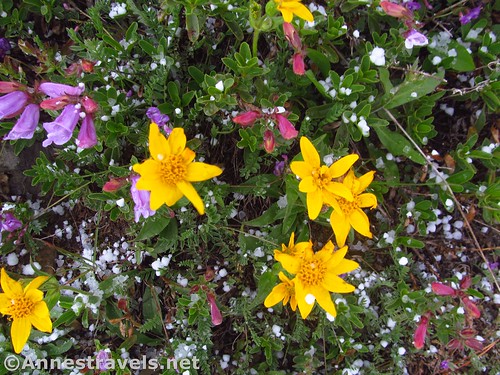
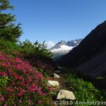
At length, the storm more or less passed, leaving ice pellets melting on the wildflowers and more pellets looking a bit like snow-berries in the stunted pine trees. We were most of the way down to the pass by then, and we enjoyed the new-fallen snow on the mountain peaks around us. And we were thankful we’d spent the money to buy ourselves quick-drying athletic clothing.
Back down on the scary curve cut out of the rock, I waited for a good second to race around the corner – even there, the wind was still so strong that it was trying to push me over the edge!

But the sun came out again, melting the snow and drying the trail. A second storm chased us up the valley back to the van, but by the time it finally came, we were back in the parking area. A bit stiff, more than a little happy, and still totally enthralled with all we had seen on the Swiftcurrent Pass Trail.

Round Trip Trail Length: I ended at 17.6 miles
Total Elevation Gain: 4,370ft. up to the lookout (4,940ft. to 8,397ft.)
Facilities: Campground, snack shop, restrooms (in the campground), cabins, and more at the trailhead. None once you leave the trailhead.
Fees: $35/vehicle/week. National Park & Federal Recreational Lands Passes and Glacier Annual Passes also accepted.
Trail Notes: This is a very, very long trail with significant elevation gain. You’ll want to be in top-notch shape before attempting it (and don’t try it if thunderstorms are predicted). While it may be tempting to only hike to Swiftcurrent Pass, if you’re in this for the views, you’ll want to hike at least partway up to the lookout.

Trail 
![]()
![]()
Road ![]()
Signs ![]()
Scenery
Would I go 100 miles out of my way for this?
Overall Rating: ![]()

GPS Coordinates for the Swiftcurrent Lookout
Trailhead: 48.7977500°, -113.6786167° (N48° 47.865′ W113° 40.717′ / 48°47’51.9000″, -113°40’43.0200″) (4,940ft.) (0.0)
End: 48.7977000°, -113.6785167° (N48° 47.862′ W113° 40.711′ / 48°47’51.7200″, -113°40’42.6600″) (4,945ft.) (17.61)
Trail junction: 48.7979333°, -113.6791667° (N48° 47.876′ W113° 40.750′ / 48°47’52.5600″, -113°40’45.0000″) (4,948ft.) (200ft.)
Fishercap Lake Junction: 48.7987667°, -113.6837333° (N48° 47.926′ W113° 41.024′ / 48°47’55.5600″, -113°41’01.4400″) (4,946ft.) (0.32)

Rockrock Lake: 48.7975333°, -113.7077833° (N48° 47.852′ W113° 42.467′ / 48°47’51.1200″, -113°42’28.0200″) (5,029ft.) (1.62)
Redrock Falls Junction: 48.7955167°, -113.7113000° (N48° 47.731′ W113° 42.678′ / 48°47’43.8600″, -113°42’40.6800″) (5,070ft.) (1.91)
Redrock Falls: 48.7951500°, -113.7108500° (N48° 47.709′ W113° 42.651′ / 48°47’42.5400″, -113°42’39.0600″) (5,054ft.) (1.96)
Regain trail: 48.7951500°, -113.7115333° (N48° 47.709′ W113° 42.692′ / 48°47’42.5400″, -113°42’41.5200″) (5,080ft.) (2.02)

Far end of Bullhead Lake: 48.7858000°, -113.7409000° (N48° 47.148′ W113° 44.454′ / 48°47’08.8800″, -113°44’27.2400″) (5,188ft.) (3.80)
Amphitheatre: 48.7802333°, -113.7432833° (N48° 46.814′ W113° 44.597′ / 48°46’48.8400″, -113°44’35.8200″) (5,271ft.) (4.33) (return 13.41)
Swiftcurrent Pass: 48.7795333°, -113.7609167° (N48° 46.772′ W113° 45.655′ / 48°46’46.3200″, -113°45’39.3000″) (7,104ft.) (7.24)
Swiftcurrent Pass (real): 48.7783500°, -113.7643333° (N48° 46.701′ W113° 45.860′ / 48°46’42.0600″, -113°45’51.6000″) (7,181ft.) (7.43)

Swiftcurrent Lookout Junction: 48.7779500°, -113.7652500° (N48° 46.677′ W113° 45.915′ / 48°46’40.6200″, -113°45’54.9000″) (7,148ft.) (7.49) (return 10.40)
Swiftcurrent Lookout: 48.7856167°, -113.7672167° (N48° 47.137′ W113° 46.033′ / 48°47’08.2200″, -113°46’01.9800″) (8,397ft.) (8.97)
View of Swiftcurrent Falls: 48.7788333°, -113.7535667° (N48° 46.730′ W113° 45.214′ / 48°46’43.8000″, -113°45’12.8400″) (6,187ft.) (12.14)

The gpx file for the Swiftcurrent Amphitheater and Swiftcurrent Lookout can be downloaded – please note that this and the GPS Coordinates are for reference only and should not be used as a sole resource when hiking this trail.
Download GPX File size: 385.1 KB Downloaded 508 times
(Note: I do my best to ensure that all downloads, the webpage, etc. are virus-free and accurate; however, I cannot be held responsible for any damage that might result, including but not limited to loss of data, damages to hardware, harm to users, from use of files, information, etc. from this website. Thanks!)

Getting to the Swiftcurrent Trailhead
From St. Mary, drive north on US-89N for 8.5 miles. Turn left in Babb, following signs for Many Glacier. After 7.5 miles, enter Glacier National Park and the road will improve. Drive another 4.8 miles to the end of the road by the Swiftcurrent Motor Inn (which is actually a gift shop). The parking area is large but usually fills up by 10am or noon during the summer season (weekdays and weekend days similarly).

From the north, drive about 10 miles south of the Canadian border to the town of Babb. Turn right, following the sign for Many Glacier, and follow the directions above to the trailhead.

Road note: As of summer 2019, the road to Many Glacier is one of the worst I’ve seen as a thoroughfare into a national park. It’s literally riddled with potholes. So slow down and use care; the people around you will be swerving to try and avoid the gaping holes in the road.

Zoom map out to browse nearby hikes & places of interest
This Week’s Featured Product!
The cool thing about this book is that while it describes some of the best hikes in Glacier National Park, it also covers the surrounding area. So you have choices for many hikes inside and outside the park.

One response to “Swiftcurrent Lookout – So Long a Hike, So Worth It!”
[…] along the Swiftcurrent Pass Trail in […]