

If there’s one classic hike in the National Parks that’s universally hailed as “don’t miss!”, it just might be the Highline Trail in Glacier National Park. Pain-for-gain, it probably has more spectacular views than most other hikes out there. That’s not to say it’s easy – trail lengths can run upwards of 15 miles, depending on how you do it. There are also sections where you’re creeping along the edge of a sheer cliff. But it’s well worth the effort, so I’ll detail two over-the-top-beautiful options in this post.
Quick Stats
(Affiliate links are present on this page.)

The first time I hiked the Highline Trail, I started at Logan Pass and ended at the Loop, where one of my group members took the free (but usually overcrowded-the-point-where-they-don’t-let-more-people-on) shuttle bus back up to Logan Pass. That ran me at about 11.7 miles. While it was totally beautiful (until the trail down to The Loop, which had no view to speak of), and almost all downhill, I expect I’ll never do it again.

For one thing, the crowed shuttle busses and road construction meant that eight of us sat at The Loop for about two hours waiting for our ride out of the mountains. Secondly, the trail from the Granite Park Chalet down to The Loop is so steep, it’s torture. It’s the worst case of shin splints I’ve ever had, and that’s considering hikes into the Grand Canyon and the Face Trail which climbs 4,100ft. in 4.5 miles. So while the shuttle hike to The Loop sounds great, I don’t recommend it.

The second time I hiked the Highline Trail (which was this past summer), I was on a time crunch, so I hiked from Logan Pass to Haystack Pass, “only” 7.6 miles RT. (Which is pretty good considering I’d hiked 17.6 miles the day before up to the Swiftcurrent Lookout.) While you do lose some great scenery by only hiking to Haystack Pass, you also get some of the best scenery along the trail – namely, looking back at Logan Pass. So if you just can’t do the entire trail, Haystack Pass makes a great place to turn around.

The Highline Trail begins on the opposite side of the Going to the Sun Road from the Logan Pass Visitor Center Parking Lot. Be aware that the parking area is usually full by 8:30am. Shuttles do run from both West Glacier and St. Mary, but they’re overcrowded and securing a spot is more or less impossible in the summer months. In my experience (and per the rangers), weekends and weekdays have similar crowds. So really, if you want to hike the trail, get to the parking area by 8:30am.

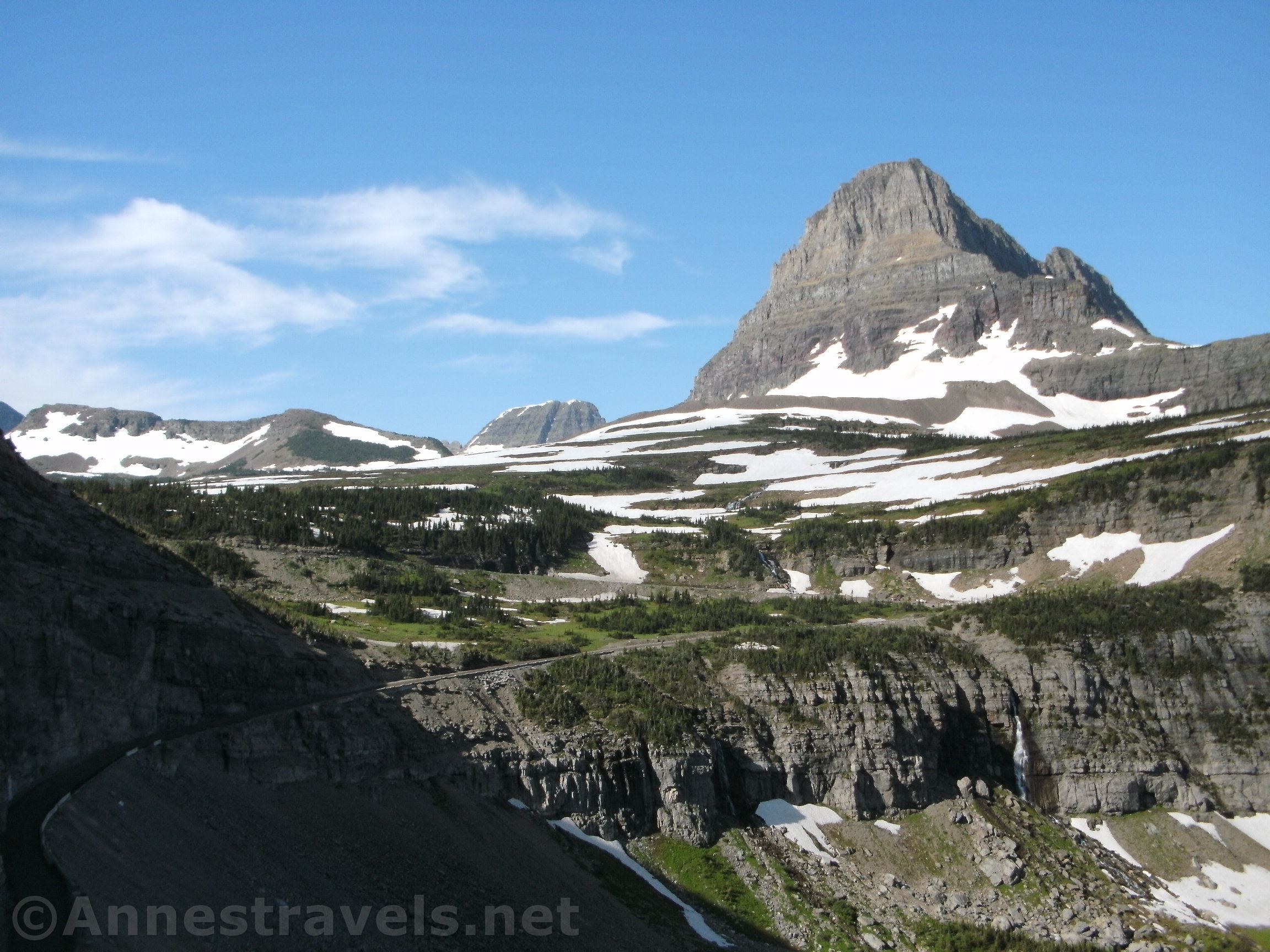
The trail descends through alpine meadows about 0.3 miles to the first section that is cut out of the rock face. Early in the season, the trail is closed until the snow and ice have melted enough for the park to install wire handrails.

The cliff section is definitely exciting, and the views are great down on the Going-to-the-Sun Road. It is wide enough for two hikers to safely pass each other, but most people don’t try passing unless one is pressed up against the cliff wall (I did pass people and didn’t feel too unsafe). If you’re prone to vertigo, the trail here will be a definite challenge. I met a woman creeping along the wall with her hat half over her face so she couldn’t see the edge. Whatever works to get you through, I guess!

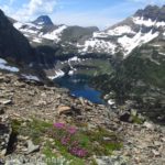
The trail eventually passes back out into meadows. There are stands of trees, meadows, and occasional views back to Logan Pass. After a second cliff section about 2 miles beyond the first, the meadows open up even more for terrific views. Besides the peaks around Logan Pass, you can also see down the valley to Heavens Peak.

Be sure to look to your right and up as you pass below Pollock Mountain, Bishops Cap, and Mt. Gould (above Haystack Pass). It’s spectacular!

Another fun thing is the numerous drainages you cross. A few are perennial creeks; others are seasonal depending on current snow levels and recent rain. The ones with water are lovely little waterfalls.

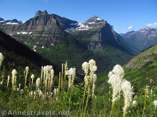
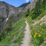
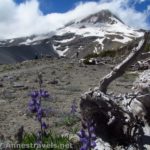
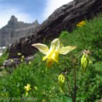
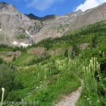
You’ll also be treated to wildflowers near the creeks as well as in the meadows. The beargrass was out in profusion on our second hike, along with several other types of wildflowers. Our first time on the trail, the path had been open for a grand four days that season, so needless to say, there was still a fair amount of snow and the wildflowers were things like glacier lilies, paintbrush, and more.

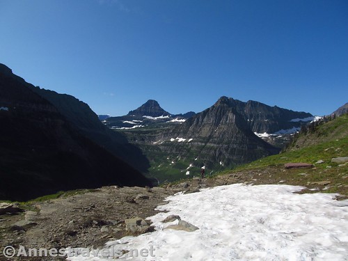
About 3 miles from the trailhead, the trail begins switchbacking upward toward Haystack Pass. You can’t miss the pass – it’s the low point between the Garden Wall and Haystack Butte, which sticks out into the valley. The trail goes through the pass (usually it has snow well into the summer season) and then continues along the Garden Wall.

Haystack Pass makes a good turn-around place if you don’t want to go all the way to the Granite Park Chalet (7.55 miles from the trailhead). You’ve seen all the views you’re going to get back toward Logan Pass (Haystack Butte blocks the views in that direction from now on). Yes, you will get more views toward Heavens Peak and surrounding peaks if you keep hiking, but at least to me, it’s not quite as spectacular as the mountains around Logan Pass.

If you want to keep hiking, continue as the trail passes rocks that (in season) have water flowing out of them and down them, along with a profusion of greenery and wildflowers. Keep walking as the trail slowly slopes downward (through lessening views) to the Garden Wall Trail junction at mile 6.8. This would be a great side-trek if you don’t mind adding another 2 miles (RT) to your hike. The Garden Wall Trail goes steeply upward to look down on Upper Grinnell Lake from above.

Continuing on the Highline Trail, the views continue to diminish as the trail descends 0.7 miles to the Swiftcurrent Pass Trail junction (technically you could turn right here and hike over Swiftcurrent Pass to Swiftcurrent Lookout or all the way to Many Glacier, some 7.75 miles from the junction). To reach the Granite Park Chalet, continue straight another 0.05 miles up the stairs.

Return to Logan Pass via the Highline Trail (all uphill!) or descend (and hope against shin splints) to The Loop 4.2 miles away.

Of course, you could also stop at any point along the Highline Trail and go back to your vehicle – even a short trek is well worth it in terms of spectacular views!

Round Trip Distance: To Haystack Pass and back is 7.6 miles; Highline to the Loop is 11.7 miles; Highline out & back to the Granite Park Chalet is 15.1 miles
Elevation Gain: To Haystack Pass and back is 2,446ft. (6,996ft. to 7,272ft.); Highline to the Loop is 1,183ft. ascent, 3,554ft. descent (7,272ft. to 6,422ft.); Highline out & back is about 4,117ft. (6,559ft. to 7,272ft.)
Facilities: Primitive and flush toilets at the Logan Pass Visitor Center along with visitor services and shuttle service. Snack bar, backcountry campground, and lodging available at the Granite Park Chalet.

Fees: $35/vehicle/week. National Park & Federal Lands Passes and Glacier National Park Annual Passes are accepted.
Trail Notes: Be prepared to share this trail with many other tourists and rugged hikers alike (and use courtesy toward all the photographers standing in the trail trying to get the perfect shot). The trailhead is especially congested. Mountain goats are common along the trail. As I’ve said before, I do not recommend the trail down to The Loop. Nor does any hiker I’ve talked to who has done it.

Trail 
![]()
![]()
Road ![]()
Signs ![]()
Scenery
Would I go 100 miles out of my way for this?
Overall Rating: ![]()

GPS Coordinates for the Highline Trail
Trailhead: 48.6966167°, -113.7181500° (N48° 41.797′ W113° 43.089′ / 48°41’47.8200″, -113°43’05.3400″) (6,575ft.) (0.0) (end 7.63)
Haystack Pass: 48.7369000°, -113.7261667° (N48° 44.214′ W113° 43.570′ / 48°44’12.8400″, -113°43’34.2000″) (6,976ft.) (3.64)
Garden Wall Trail Junction: 48.768036°, -113.758314° (N48°46.08216′, W113°45.49884′) (6,581ft.) (6.8)
Swiftcurrent Pass Junction: 48.771372°, -113.770822° (N48°46.28232′, W113°46.24932′) (6,663ft.) (7.5)
Granite Park Chalet: 48.7709120°, -113.772301° (N48°46.25472′, W113°46.33806′) (6,681ft.) (7.55)
The gpx file for the Highline Trail to Haystack Pass can be downloaded – please note that this and the GPS Coordinates are for reference only and should not be used as a sole resource when hiking this trail.
Download GPX File size: 125.0 KB Downloaded 514 times

The gpx file for the Highline Trail to the Granite Park Chalet can also be downloaded – please note that this and the GPS Coordinates are for reference only and should not be used as a sole resource when hiking this trail.
Download GPX File size: 76.4 KB Downloaded 499 times
(Note: I do my best to ensure that all downloads, the webpage, etc. are virus-free and accurate; however, I cannot be held responsible for any damage that might result, including but not limited to loss of data, damages to hardware, harm to users, from use of files, information, etc. from this website. Thanks!)

Getting to the Highline Trailhead (Logan Pass)
From St. Mary, take the Going-to-the-Sun Road into the park. After passing through the entrance station, drive 17.5 miles up the road to the top of Logan Pass. Turn left into the parking area.
From West Glacier, turn off of US-2 to pass under the railroad bridge, following signs for Glacier National Park. Pass through the entrance station and continue to the four-way stop. Turn right following the sign for the Going-to-the-Sun Road and drive 30.0 miles to the top of Logan Pass. Turn right into the parking area.

Note: The parking area at Logan Pass is usually full by 8:30am in the summer months (weekends and weekdays). People leave, but not half often enough for everyone trying to park. There is a park shuttle, but it is overcrowded and some people wait two hours just to get on the shuttle bus. So my best advice is to get there early!


Zoom map out to browse nearby hikes & places of interest
This Week’s Featured Product!
I really like this trail guide to Glacier National Park. It’s an eBook, but it’s a good one. And you won’t break the bank buying it!

One response to “The Spectacular Wonders of the Highline Trail”
[…] decided to take it a little easier the next day, so we hiked the Highline Trail to Haystack Pass. There had been a bear incident on the trail a few days earlier, but the trail was reopened to […]