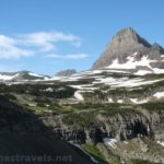

For sheer beauty, it’s hard to beat the Reynolds Mountain Trail in Glacier National Park. The trail is virtually unknown – the signs that do exist don’t help its popularity. But since you get to hike the Hidden Lake Trail, then continue on through meadows, snowfields, and rockslides to a pass overlooking Hidden Lake, then hike along the side of Reynolds Mountain to another pass overlooking another stunningly beautiful valley, it’s well worth the effort it takes to get there. You can also continue up the Dragontail for even more views of Hidden Lake and the surrounding mountains.
Quick Stats
Note: Some of the links in this post are affiliate links. If you click one and purchase something, I may earn a small commission without an extra cost to you.

We heard about the Reynolds Mountain Trail from an old ranger at Logan Pass and hiked the trail that afternoon. (Surprisingly enough, the Reynolds Mountain Trail doesn’t go up Reynolds Mountain.) I also found a PDF of the trail on the National Park Service website, but the trail map had the trail on the wrong side of the mountain (I don’t even know how you could hike on that side of the mountain; there’s certainly no trail). So it’s not well known, but it is an official trail of Glacier National Park.

The trailhead is Logan Pass, and unless you get there before 8:30am (at least during the summer months), parking will be your biggest headache. We tended to arrive about 7am and we had our choice of parking spots.

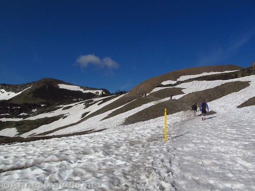
Begin on the Hidden Lake Trail (walk up to the stairs from the parking area and you’ll see the sign). The path often has snow cover well into the summer months, so expect to be walking on snow. The snow has been packed down, melted, refrozen, and trampled by so many feet that it can be quite slick in places.
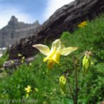
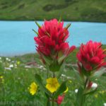
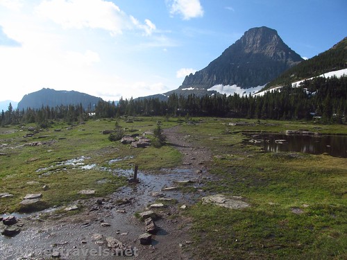
This part of the trail is worth hiking in itself. The views to Reynolds Mountain across the Hanging Gardens are totally spectacular, especially if the wildflowers are blooming!

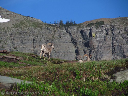
We met a family of mountain goats along the trail, plus we saw several more on our way back. I gather the mountain goats hang out around here, to the delight of visitors.

Continue up the Hidden Lake Trail to the end of the last boardwalk before the Hidden Lake Overlook, 1.2 miles from the trailhead. A trail goes off on the left, right next to a sign telling hikers to stay on official trails. Don’t worry; the Reynolds Mountain Trail is an official trail, and you just need to stay on it to comply with the rules.
I highly recommend continuing on the Hidden Lake Trail another 0.2 miles to the Hidden Lake Overlook. It’s a very different angle than you’ll be seeing later, and it’s just overall a great view.

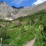
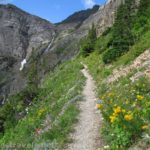
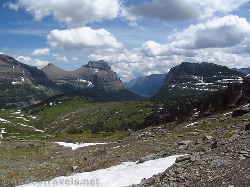
Back at the Reynolds Mountain Trail, strike off on the trail as it travels south-ish through the trees and meadows and across rock fields and snowfields. Views are spectacular back toward Logan Pass and St. Mary Lake, as well as the rapidly approaching Reynolds Mountain.
About the time we had turned onto the Reynolds Mountain Trail, a mountain goat decided that he liked following the trail. He got between me and the rest of my group, trotting along. I didn’t want to get too close to him (they are wild after all!), but he had no intention of letting me past him, either, for quite a while.

A mile from the Hidden Lake Trail, you’ll arrive at the first pass. If you’re short on time, this is a great place to turn around: the views are stunning to Bear Hat Mountain, Hidden Lake, and surrounding peaks and cliffs, not to mention back over the other side toward Logan Pass. It’s jaw-dropping!

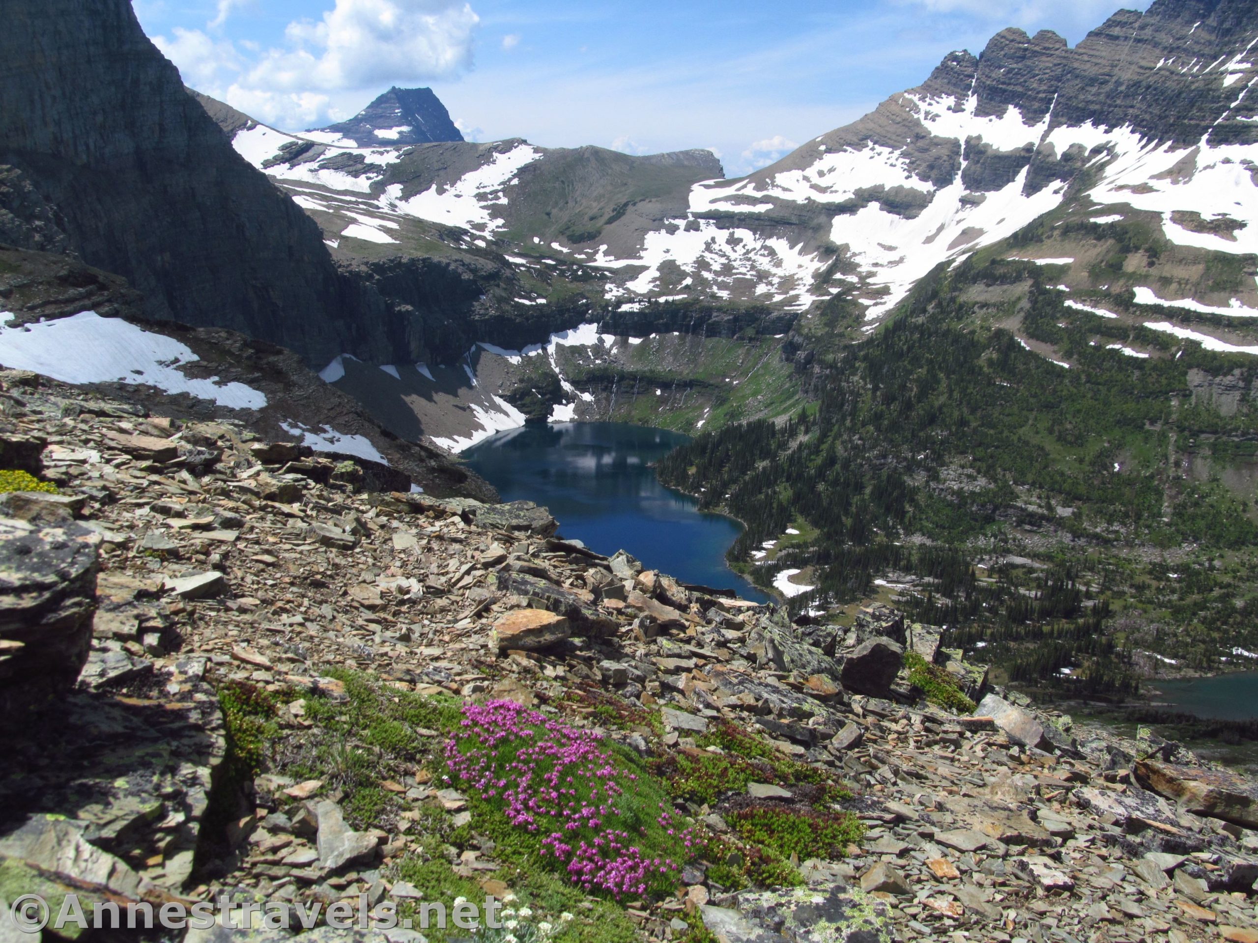
But for even more views – and some of my favorite views of Hidden Lake – turn left to continue up the pass and along the western face of Reynolds Mountain. The trail here looks social, and it might be. But it’s good enough that even my group members who are afraid of heights didn’t have much issue. That said, the exposure is pretty impressive.

The views open up of the far southwestern end of Hidden Lake and the waterfalls that feed it. To me, this is the real beauty of Hidden Lake.
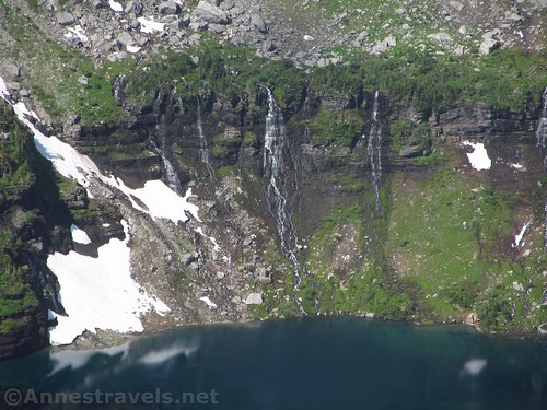
Less than a mile beyond the first pass is a second pass, separating Reynolds Mountain from the Dragontail. Here, if you wanted to hike Reynolds Mountain, you would turn left to begin ascending the very steep talus slopes. Plenty of people do it, but there’s no trail, and you’d better have some pretty good scree-climbing skills (Class 3). For the rest of us, we can sit back and enjoy the fantastic views down into the valley. It’s studded with lakes, and you get a pretty good view of a permanent snowfield – on the other side of the ridge from this snowfield is the Sperry Glacier (actually, you can see part of the glacier through a low spot in the ridge).

You would be perfectly content to sit here for hours – at least, my group was. But several of us scrambled up the Dragontail (to the right of the pass). It’s narrow and rocky – somewhat reminiscent of Cloud’s Rest – but it is hikable (Class 2 and mild Class 3). You can go 0.3 or 0.4 miles before we came to a rift we would rather not cross. Still, the views from here are jaw-gaping of Hidden Lake, Bear Hat Mountain, Logan Pass, and so, so many surrounding mountains. Oh, wow!

And would you know it? That pesky mountain goat followed us up the Dragontail!

The views were so amazing. But the rest of the group was waiting for us, so we reluctantly scrambled back down to the pass and followed the trail back to the Hidden Lake Trail – which is no fun at all on a summer afternoon. “I saw hikers in parkas,” one group member told me, “I saw hikers in bathing suits. I felt like I was swimming upstream against a crowd of people!”

All the more reason to start your hike early and end it late, I guess!

Round Trip Trail Length: Taking in the Hidden Lake Overlook and the Dragontail, I ended at 7.2 miles
Elevation Change: Up to 1,518ft. (6,661ft. at the trailhead to 8,179ft. up on the Dragontail)
Facilities: Primitive restrooms at the trailhead are open 24/7; more civilized restrooms are located outside the visitor center
Fees: $35/vehicle/7 days. National Parks & Federal Lands Passes and Glacier Annual Passes also accepted.
Trail Notes: This is not a stroll in the park. You will be crossing steep snowfields and there are scree areas with some exposure. That said, if you’re a good hiker, you should do just fine.

Trail 
![]()
![]()
Road ![]()
Signs ![]()
![]()
Scenery
Would I go 100 miles out of my way for this?
Overall Rating: ![]()

GPS Coordinates for the Reynolds Mountain Trail
Trailhead: 48.6954000°, -113.7184667° (N48° 41.724′ W113° 43.108′ / 48°41’43.4400″, -113°43’06.4800″) (6,661ft.) (0.0)
Reynolds Mountain Junction: 48.6877833°, -113.7376667° (N48° 41.267′ W113° 44.260′ / 48°41’16.0200″, -113°44’15.6000″) (7,120ft.) (1.19) (return 1.64 and 6.00)
Hidden Lake Overlook: 48.6872167°, -113.7416667° (N48° 41.233′ W113° 44.500′ / 48°41’13.9800″, -113°44’30.0000″) (7,118ft.) (1.41)
1st Pass: 48.6768833°, -113.7320000° (N48° 40.613′ W113° 43.920′ / 48°40’36.7800″, -113°43’55.2000″) (7,549ft.) (2.65) (return 4.86)
2nd Pass: 48.6690000°, -113.7299833° (N48° 40.140′ W113° 43.799′ / 48°40’08.4000″, -113°43’47.9400″) (7,841ft.) (3.47) (return 4.17)
Top of the Dragontail (for me): 48.6665167°, -113.7345833° (N48° 39.991′ W113° 44.075′ / 48°39’59.4600″, -113°44’04.5000″) (8,179ft.) (3.8)
End: 48.6954500°, -113.7183500° (N48° 41.727′ W113° 43.101′ / 48°41’43.6200″, -113°43’06.0600″) (6,690ft.) (7.19)

The gpx file for the Reynolds Mountain Trail can be downloaded – please note that this and the GPS Coordinates are for reference only and should not be used as a sole resource when hiking this trail.
Download GPX File size: 154.5 KB Downloaded 417 times
(Note: I do my best to ensure that all downloads, the webpage, etc. are virus-free and accurate; however, I cannot be held responsible for any damage that might result, including but not limited to loss of data, damages to hardware, harm to users, from use of files, information, etc. from this website. Thanks!)

Getting to the Reynolds Mountain Trail
From St. Mary, take the Going-to-the-Sun Road into the park. After passing through the entrance station, drive 17.5 miles up the road to the top of Logan Pass. Turn left into the parking area.
From West Glacier, turn off of US-2 to pass under the railroad bridge, following signs for Glacier National Park. Pass through the entrance station and continue to the four-way stop. Turn right following the sign for the Going-to-the-Sun Road and drive 30.0 miles to the top of Logan Pass. Turn right into the parking area.

Note: The parking area at Logan Pass is usually full by 8:30am in the summer months (weekends and weekdays). People leave, but not half often enough for everyone trying to park. There is a park shuttle, but it is overcrowded and some people wait two hours just to get on the shuttle bus. So my best advice is to get there early!

This Week’s Featured Product!
If you’re looking for even more trails in Glacier National Park, this highly-rated guide suggests 40 of the best routes in the park.