

As many of you know, I’m not huge into alpine lakes. They’re nice enough if they have a good view around them, but a lake for a lake’s sake is not my idea of fun. (But maybe that’s because I can walk to a huge lake any time I feel like it?) At any rate, on our visit to Glacier National Park last summer, the day was forecasted to be cloudy. So why not spend a cloudy day hiking to a lake? That way, if the mountains were socked in, at least we’d still get the lake. And so, without really deciding to do so, we set off for Iceberg Lake.
Quick Stats
(Affiliate links are present on this page.)

The good news is that Iceberg Lake really is a worthwhile destination. The views along the trail are pretty spectacular and the lake itself is set in a sheer rocky cirque, which adds to the sense of drama. And did I mention that there are icebergs galore in the lake? It’s no wonder this is often cited as one of the best hikes in Glacier!
Our only real mistake was that we didn’t park at the trailhead. There is room for about a dozen cars right next to the Iceberg Lake Trailhead. I didn’t know it was there, so, despite the fact that there were only four or so cars at the trailhead, we parked in the large parking area by the Swiftcurrent Motor Inn not far from the sign for Swiftcurrent Pass. If the trailhead parking is full – and it fills up fairly quickly – there still might be space in the larger parking lot. It will add about 0.5 miles to the hike overall.
To get to the trailhead, and the trailhead parking, follow the Iceberg-Ptarmigan sign toward the cabins (a right turn after passing the Swiftcurrent Motor Inn aka a gift shop). Take an immediate left and stay left to the trailhead, which is signed for Iceberg Lake and Ptarmigan Tunnel.

Almost at once, the trail splits. Turn right toward Iceberg Lake among other destinations. Less than a half mile (but a steep climb) later, the trail will junction a second time; turn left to follow the sign toward Iceberg Lake and Ptarmigan Tunnel.
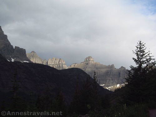
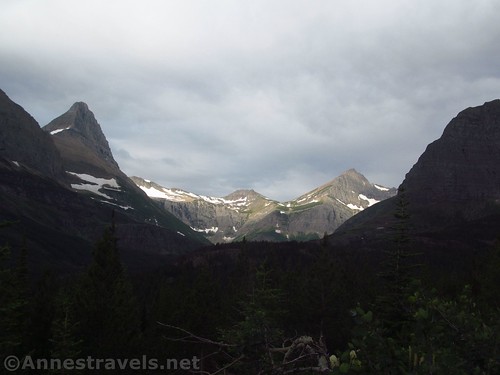
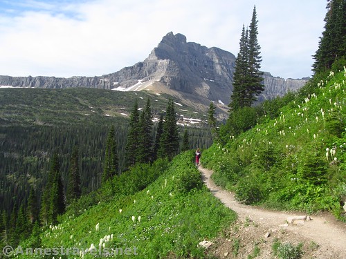
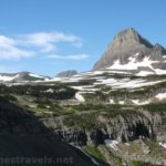
The path levels out in hillside meadows. The views are spectacular of the peaks around Swiftcurrent Pass and the Ice Wall. The day was cloudy where we were, but both the Pass and the Wall were in sunshine – making for some pretty striking photographic opportunities.
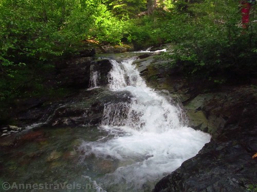
Continue as the trail winds generally upward through the meadows and then through the forest. A short trail to a toilet branches right at mile 2.75 (not the worst toilet I’ve seen, but definitely not the best either). Hiking along the main trail for another 0.1 miles will bring you to Ptarmigan Falls.

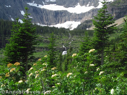
I don’t know why they make such a big deal about Ptarmigan Falls, because to be honest, you can’t see it. You get one peek-a-boo view well before you get to the bridge. Otherwise, all you can do is hear that Ptarmigan Falls exists (well, you can see the brink from a few places, but that’s not seeing the falls to me). Much more exciting is the bridge across Ptarmigan Creek – and that’s not exciting, just pretty with a little waterfall upstream.
Less than a quarter mile beyond the bridge over Ptarmigan Creek, the trail to the Ptarmigan Tunnel forks right (the junction is well-marked). All other things being equal, we would have been hiking to the tunnel. But since it was still iced in per the park rangers, we reluctantly turned left toward Iceberg Lake.

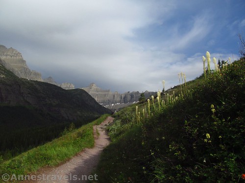
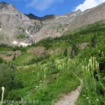
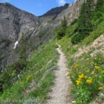
For the next 2 miles, the trail passes through some of the best scenery on the trail (at least in my humble opinion). Once it finally breaks out of the forest, the views open up toward the Ice Wall, the cirque surrounding Iceberg Lake, and the various meadows and mountains near the trail. It was glorious hiking on a somewhat sunlit morning with only a few people on the trail (be prepared for crowds by noon).

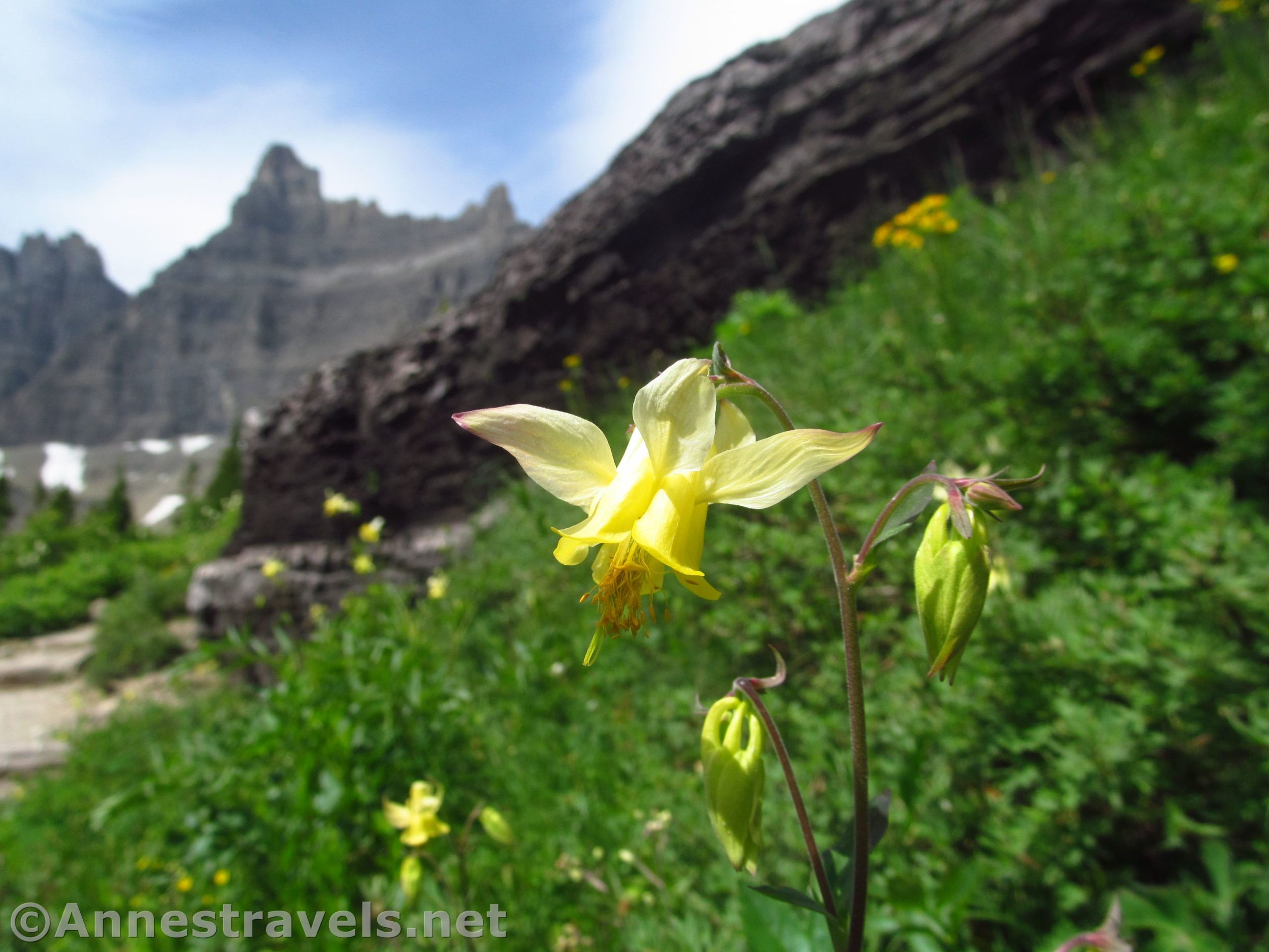
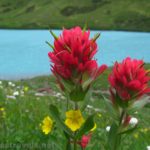
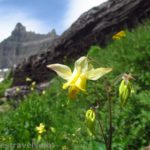
The wildflowers were out in places, making the trail even more special. I especially enjoyed the beargrass and the few Western Columbine flowers, but I also saw paintbrush, subalpine spiraea, arnica, and glacier lilies, among others. The views toward the waterfall in Iceberg Lake’s outlet were also very nice.

Eventually, the trail crosses over Iceberg Lake’s outlet. There are signs everywhere in this area saying to stay on the trail. Use your best judgment as to which is the right trail. The important thing is to not deviate from the trail heading to Iceberg Lake.

About 5.0 miles from the trailhead, a sign will point toward a second pit toilet (much nicer than the one down below). A hitchrack is nearby; horses are not allowed at Iceberg Lake.

The trail crests the hill above the lake right about the junction for the pit toilet, so it’s just a quick 0.25 mile ramble down to the lakeshore. The views are pretty good over the lake during the descent.
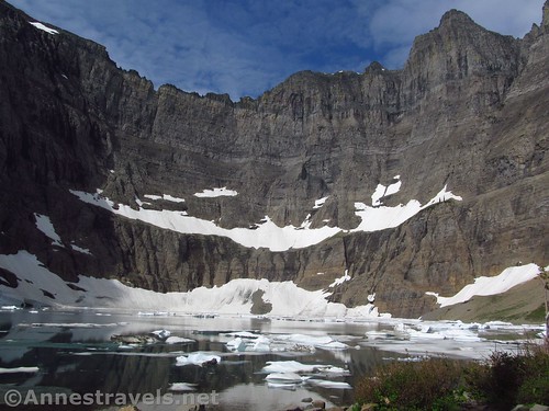
The lakeshore itself is usually overrun. You can probably find a little solitude by walking right or left along the lakeshore and doing a little bushwhacking to a quieter portion of the shoreline. Most people don’t get further than the first rocky beach.

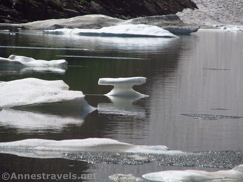
We bushwacked right and had lunch sitting on rocks with icebergs floating a few feet away. How cool is that?
Retrace your steps to return to the parking area. Because we had started are hike about 7am, we had the “joy” of fighting the crowds the whole way back. But really, the views and the icebergs made it so worth it!
Round Trip Trail Length: 10.1 miles from the trailhead (add 0.5 miles if you park in the Swiftcurrent parking lot)
Total Elevation Gain: 2,058ft. (4,927ft. to 6,156ft.)
Facilities: Two pit toilets along the trail. The trailhead also has restrooms (walk into the campground) and the Swiftcurrent Motor Inn (snack bar and gift shop). Visitor services, campground (usually full), lodge, cabins, etc. are located nearby.
Fees: $35/vehicle/week. National Park & Federal Recreational Lands Passes and Glacier Annual Passes also accepted.
Trail Notes: The trail is long enough (10 miles isn’t exactly short) but the lack of significant elevation gain and the lower elevation than the hikes up at Logan Pass make it easier than some other trails. I would highly recommend a side-trek up to Ptarmigan Tunnel (5 mile RT extra) if you have the time – or maybe it would be better to hike it on its own day if you don’t want a 15 mile day hike!

Trail 
![]()
![]()
Road ![]()
Signs
Scenery
Would I go 100 miles out of my way for this?
Overall Rating: 

GPS Coordinates for Iceberg Lake
Trailhead: 48.7978333°, -113.6778167° (N48° 47.870′ W113° 40.669′ / 48°47’52.2000″, -113°40’40.1400″) (4,957ft.) (0.0) (end 10.59)
Trailhead: 48.7995000°, -113.6791667° (N48° 47.970′ W113° 40.750′ / 48°47’58.2000″, -113°40’45.0000″) (4,966ft.) (0.17)
Real Trailhead: 48.7997333°, -113.6793167° (N48° 47.984′ W113° 40.759′ / 48°47’59.0400″, -113°40’45.5400″) (4,969ft.) (0.20) (Return 10.42)
Trail Junction: 48.8000000°, -113.6792333° (N48° 48.000′ W113° 40.754′ / 48°48’00.0000″, -113°40’45.2400″) (4,979ft.) (0.24)
Trail Junction: 48.8025500°, -113.6798833° (N48° 48.153′ W113° 40.793′ / 48°48’09.1800″, -113°40’47.5800″) (5,139ft.) (0.48)
Toilet Junction: 48.8205333°, -113.7116833° (N48° 49.232′ W113° 42.701′ / 48°49’13.9200″, -113°42’42.0600″) (5,669ft.) (2.73)

Ptarmigan Falls: 48.8216500°, -113.7115667° (N48° 49.299′ W113° 42.694′ / 48°49’17.9400″, -113°42’41.6400″) (5,694ft.) (2.84)
Ptarmigan Pass Trail Junction: 48.8223333°, -113.7131833° (N48° 49.340′ W113° 42.791′ / 48°49’20.4000″, -113°42’47.4600″) (3.02)
Toilet Junction: 48.8171000°, -113.7408500° (N48° 49.026′ W113° 44.451′ / 48°49’01.5600″, -113°44’27.0600″) (6,128f.) (5.02)
Iceberg Lake: 48.8156167°, -113.7421333° (N48° 48.937′ W113° 44.528′ / 48°48’56.2200″, -113°44’31.6800″) (6,073ft.) (5.25)

GPS, etc.
The gpx file for Iceberg Lake can be downloaded – please note that this and the GPS Coordinates are for reference only and should not be used as a sole resource when hiking this trail.
Download GPX File size: 178.8 KB Downloaded 470 times
(Note: I do my best to ensure that all downloads, the webpage, etc. are virus-free and accurate; however, I cannot be held responsible for any damage that might result, including but not limited to loss of data, damages to hardware, harm to users, from use of files, information, etc. from this website. Thanks!)

Getting to the Iceberg Lake Trailhead
From St. Mary, drive north on US-89N for 8.5 miles. Turn left in Babb, following signs for Many Glacier. After 7.5 miles, enter Glacier National Park and the road will improve. Drive another 4.8 miles to the end of the road by the Swiftcurrent Motor Inn (which is actually a gift shop). Turn right about halfway down the parking lot, following the sign for Iceberg-Ptarmigan Trailhead. Take an immediate left and drive 0.1 miles to the trailhead. The parking area here is small and can only accommodate about a dozen cars. You can also park by the Swiftcurrent Motor Inn, but despite the fact that the lot is large, it usually fills up by 10am or noon during the summer season (weekdays and weekend days similarly).

From the north, drive about 10 miles south of the Canadian border to the town of Babb. Turn right, following the sign for Many Glacier, and follow the directions above to the trailhead.

Road note: As of summer 2019, the road to Many Glacier is one of the worst I’ve seen as a thoroughfare into a national park. It’s literally riddled with potholes. So slow down and use care; the people around you will be swerving to try and avoid the gaping holes in the road.

Zoom map out to browse nearby hikes & places of interest
This Week’s Featured Product!
Check out some of the best trails in Glacier National Park in this hiking guide! Written by a woman who has been trekking the park for more than 30 years, it’s full of historical and practical information.

One response to “Icebergs & Views at Iceberg Lake”
[…] Columbine along the Iceberg Lake Trail in Glacier National […]