There are a few great things about climbing Wildrose Peak in Death Valley National Park: 1) You get a great view of Death Valley, 2) You don’t need a 4×4 or high clearance vehicle to get to the trailhead, 3) It’s not as long or as hard as the trail to Telescope Peak, and 4) It’s a lot lower than Telescope Peak – which means it’s snow-free more of the year. Wildrose Peak is still up in the mountains, though, so it’s a lot cooler than down in the sweltering valley! And did I mention that the views are fantastic?
Quick Stats
Note: Some of the links in this post are affiliate links. If you click one and purchase something, I may earn a small commission without an extra cost to you.
If you’re on the fence about whether you should climb Telescope Peak (the highest point in Death Valley National Park) or Wildrose Peak, here are a few things to take into consideration. First, the Wildrose Peak Trail is considerably shorter than the trail to Telescope Peak (8.5 miles vs. 13.2 miles) and has less elevation gain (2,728ft. vs. ~4,000ft.). Second, altitude sickness is less of an issue on Wildrose Peak, since it’s about 2,000ft. lower than Telescope Peak. – the lack of elevation also means it’s typically snow-free into December and by May, while Telescope Peak may cling to snow from November to June.

With all of those stats, you may wonder why anyone would choose to hike Telescope Peak. It does come with bragging rights (I’ve done it myself – “I was at -282ft. below sea level and the highest peak in Death Valley – the greatest vertical rise above the local terrain in the continental US – in less than 24 hours”).

Telescope Peak also has better scenery, at least to my eye. While Wildrose has pretty badlands and great views of Death Valley, Telescope Peak has even better views of Death Valley plus great views into China Lake. (Hiking up Bennett Peak, while it’s not quite as impressive at hiking Telescope Peak, is at least similar when it comes to scenery.) So all that to say, the choice is up to you – both Wildrose Peak and Telescope Peak are fantastic hikes, so I can highly recommend both!

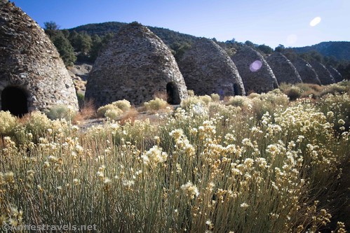
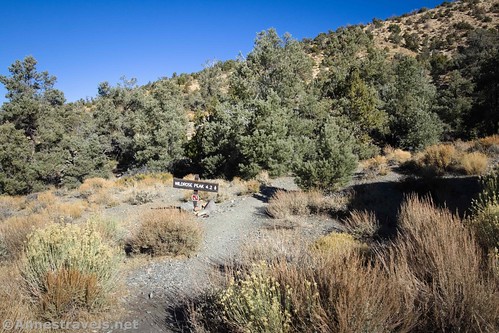
The trailhead for Wildrose Peak is at the Charcoal Kilns high in the Panamint Mountains above the Wildrose Campground (aka the closest water to the trailhead). The trail begins on the far left (west) end of the kilns. It’s well-marked, so you shouldn’t have any trouble finding it.
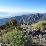
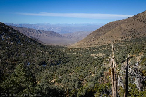
The trail rises through the trees to work its way along the shoulder of the hill. Views are excellent in this section down Wildrose Canyon to the High Sierras and also up Wildrose Canyon.
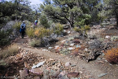
The trail itself really isn’t that interesting. There’s great variety in flora and otherwise, it just sort of works its way up uphill, steeply but not crazy steep, wide most of the time, just totally nondescript. The path reaches the ridgeline about mile 1.75 and turns left (north) to continue upward.
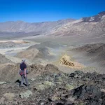
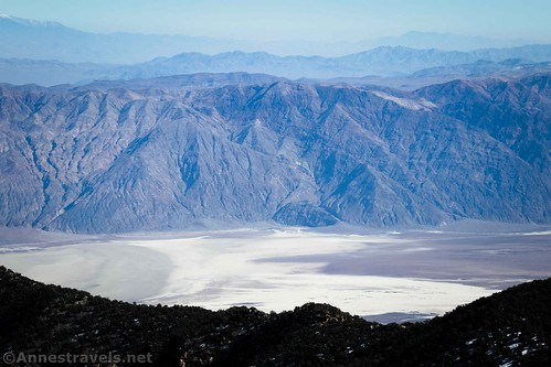
At about 3 miles from the trailhead, the first good view of Death Valley is to be had to the right off of the trail. It’s a foretaste of what’s to come.
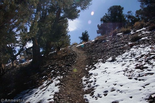
After the viewpoint, the trail keeps heading upward for about 0.4 miles and then begins to switchback up through the thinning trees. This is a great sign – you’re almost there!
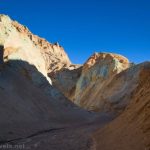
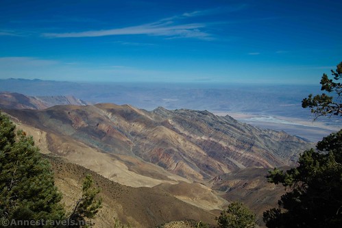
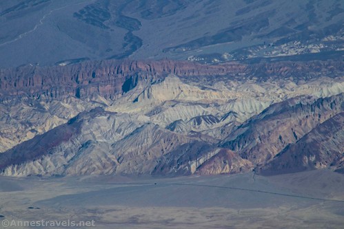
The views across the valley to the Black Mountains – especially the badlands around Golden Canyon and the Red Cathedral – are beautiful as you climb higher.
One final push brings you to the top of the peak. Wow!

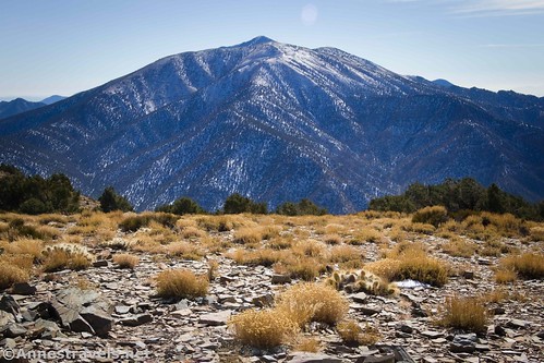
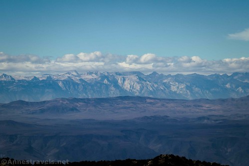
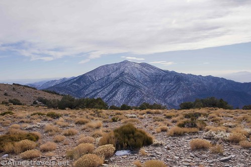
To the northwest are the High Sierras – including Mt. Whitney. The beautiful striped badlands beyond Trail Canyon are to the northeast, with Death Valley and the Black Mountains to the east. To the south is Telescope Peak – all of it is beautiful!
The only problem is that it’s so hard to capture with a camera. It’s so much better in real life than what the photos show!
The fresh snow on the surrounding mountains made it even more special. It was pretty cold up there, though, especially with the wind. We hunkered down on the lee side of the mountain to eat lunch, but it was still cold. We didn’t stay much beyond lunch because we wanted to get moving – and get warm – again.

When you’ve had your fill of views, head back down to the parking area. The trail itself may be nondescript, but the views from the top are great!

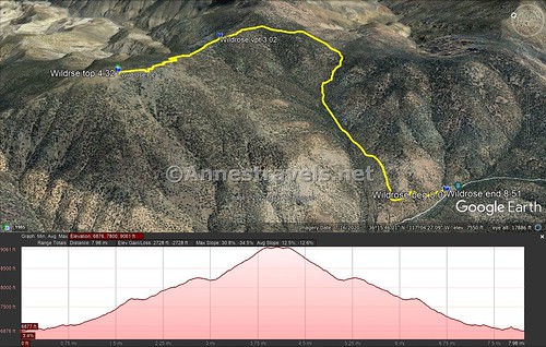
Trail Length: 8.5 miles out & back
Elevation Gain: 2,728ft. (6,876ft. to 9.061ft.)
Facilities: Restroom at the trailhead
Fees: $30/vehicle, valid 7 days. America the Beautiful Federal Public Lands Passes and Death Valley Annual Passes are also accepted.

Trail Notes: The trail is mostly uphill, and it’s a lot higher than the surrounding area. So if you get winded easily or even fall for some altitude sickness don’t worry! Be sure to check out the Charcoal Kilns at the trailhead before you leave. The drive up the Emigrant Canyon Road is beautiful, so you’ll get a scenic drive as well as the hike.

Trail 
![]()
![]()
Road ![]()
Signs ![]()
Scenery
Would I go 100 miles out of my way for this?
Overall Rating: ![]()

GPS Coordinates for Wildrose Peak
Wildrose Peak Trailhead: 36.2472167°, -117.0766333° (N36° 14.833′ W117° 04.598′ / 36°14’49.9800″, -117°04’35.8800″) (6,844ft.) (0.0)
Viewpoint: 36.2713667°, -117.0649667° (N36° 16.282′ W117° 03.898’/ 36°16’16.9200″, -117°03’53.8800″) (8,230ft.) (3.02)
Top of Wildrose Peak: 36.2755333°, -117.0787833° (N36° 16.532′ W117° 04.727′ / 36°16’31.9200″, -117°04’43.6200″) (9,053ft.) (4.32)
End: 36.2472333°, -117.0766167° (N36° 14.834′ W117° 04.597′ / 36°14’50.0400″, -117°04’35.8200″) (6,861ft.) (8.51)
The gpx file for Wildrose Peak can be downloaded – please note that this and the GPS Coordinates are for reference only and should not be used as a sole resource when hiking this trail.
Download GPX File size: 154.2 KB Downloaded Invalid download ID. times
(Note: I do my best to ensure that all downloads, the webpage, etc. are virus-free and accurate; however, I cannot be held responsible for any damage that might result, including but not limited to loss of data, damages to hardware, harm to users, from use of files, information, etc. from this website. Thanks!)

Getting to Wildrose Peak
From Furnace Creek, drive north on CA-190W, the main north-south road through Death Valley (toward Beatty, though you’re not actually going to Beatty). After 33 miles, turn left onto Emigrant Canyon Road (follow the sign for Wildrose). Continue about 30 miles to the trailhead.

From Panamint Springs, head northeast on CA-190E for 21.4 miles. Turn right onto Emigrant Canyon Road; continue about 30 miles to the trailhead.
Note: Emigrant Canyon Road is dirt and quite rough. Most vehicles should be able to access the Charcoal Kilns; beyond this, high clearance may be required, although almost all the cars I’ve seen at the trailhead were low-clearance.
This Week’s Featured Product!
With almost 60 different trails, this book is a great one to have with you when you’re hiking or planning on hiking in Death Valley. It has maps, directions, and more.