

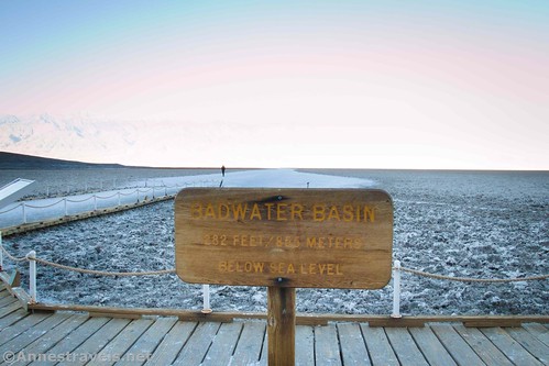
Thousands of tourists and visitors to Death Valley stop at the Badwater Basin Trailhead. They pose with the sign that says it’s the lowest point in North America at -282ft. But that sign is not actually the lowest point. For one thing, it’s up on the boardwalk (maybe a foot off the ground), but for another, that portion of the Badwater Salt Flats is actually only -272ft. – about 10 feet above the lowest point in North America. And so we set out to find the literal lowest point in North America, ‘way out on the salt flats. I had GPS coordinates, so I figured we couldn’t get too lost. And while we were at it, we decided to do an out-and-back walk across Death Valley. Going to the lowest point added about a mile to the overall crossing, but it was worth it to know that I’ve literally stood in the lowest place in North America!
Quick Stats

Note: There are two times that you should NOT attempt this hike: 1) from May to October or any time the heat is oppressive, and 2) when the salt flats are wet – your footprints in the soft mud could last decades before disappearing!

We knew this was an all-day hike, so we started early. Badwater Basin was still in the shadow of the Black Mountains to the east. Five of us had hiked all the way across Death Valley twice before, once in 2006 and again in 2009, and we were thrilled to do it again. The others had only heard us rave about it – and they’d driven the van around from the West Side Road to Badwater Basin to pick us up both times. This time, we parked at Badwater Basin and did an out-and-back trek – a total of 12 miles without adding the lowest point in North America; 13 miles with the side-trek – so we could all enjoy the beauty of the Badwater Salt Flats!
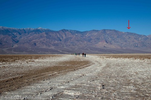
We followed the well-beaten path across the salt flats for about 0.9 miles, then it abruptly ended. From there, we headed in the general direction that my GPS coordinates indicated (RIP panamintcity.com…) For the most part we just shot for two small peaks right next to each other on the ridgeline. They led us almost directly to the Lowest Point.
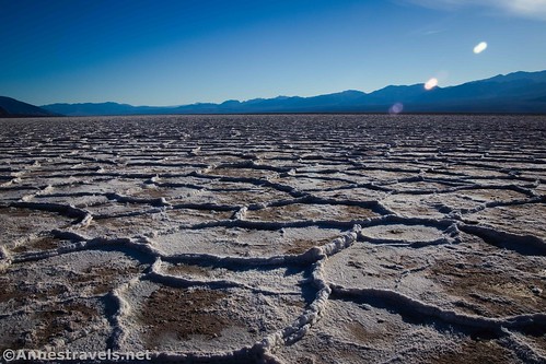
Sometimes the salt flats are brown, other times they are white. Exactly what is white or brown is dependent on current conditions. Walking isn’t all that easy because there are constant small ridges to step over. It’s like trying to walk down the sidewalk and not step on any cracks, only the cracks are 6-12” tall. So it’s a constant game of watching your feet, watching where you’re going, watching your feet, making sure you’re going the right way, so on and so forth, all while squinting into the bright dazzle of the reflecting salt crystals. I’m not trying to paint a dismal picture, but this is not an easy, let’s-go-for-a-stroll kind of hike!

The views of both the salt flat and of the Panamint Mountains to the west (including Telescope Peak) are fantastic! There are rarely crowds this far out on the salt flats, and you’re far enough away that you can’t even see the people. It’s like you’re alone out here in this wild and wacky landscape with all the views to yourself…

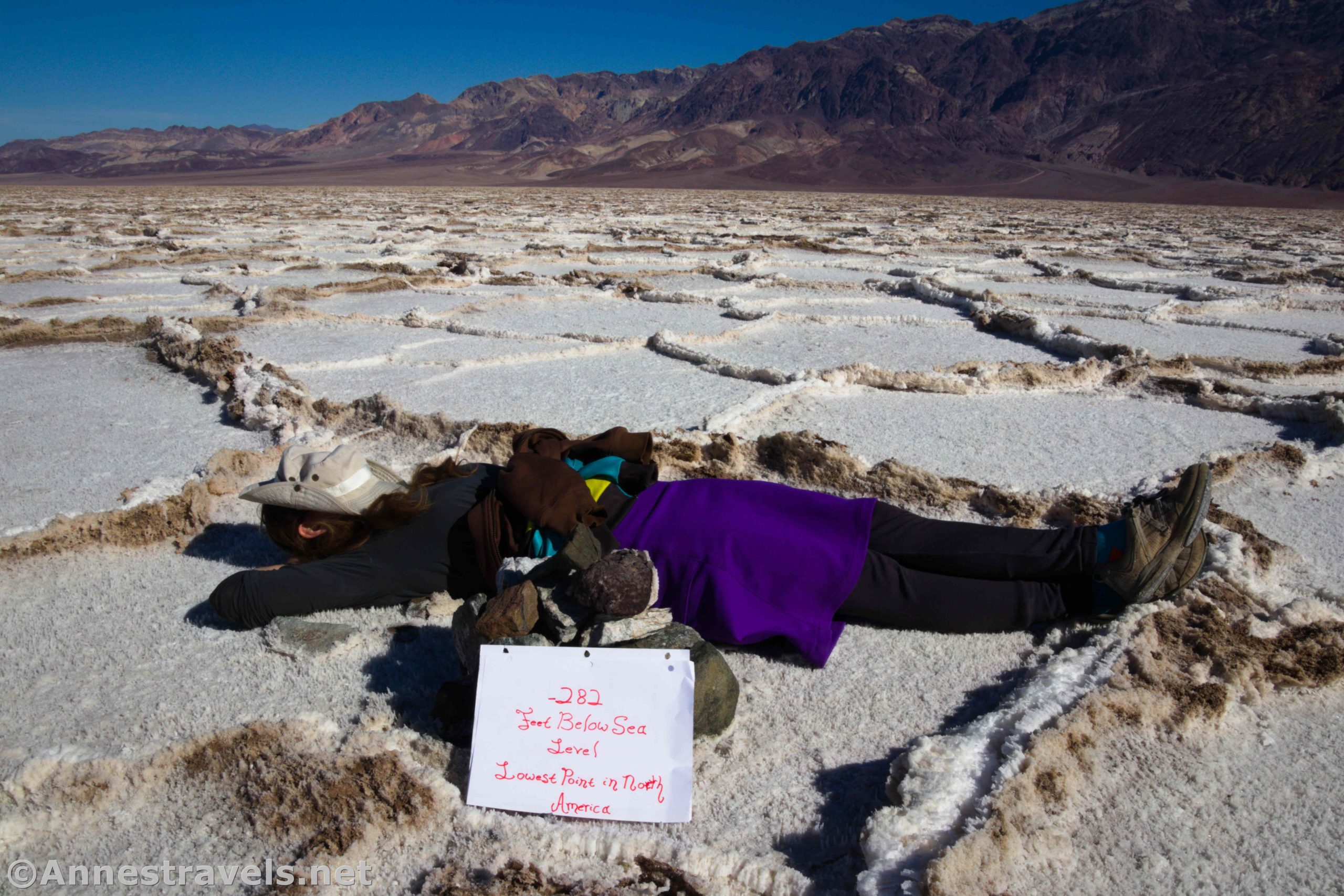
About 3.6 miles from the trailhead, we found the cairn that marks the Lowest Point in North America. My GPS concurred: it really is -282ft.!

Actually, there are several places in Badwater Basin that are -282ft. This is just one of them. But it’s still one of the lowest points in North America!

From there, you can return to your vehicle for a 7.2 mile hike. But we decided to keep walking to the other side. (After all, it’s super cool to be able to say you’ve walked all the way across Death Valley, right?) Thankfully we had a coolish day, so even with the heat rising out of the salt flats, it wasn’t oppressively hot.
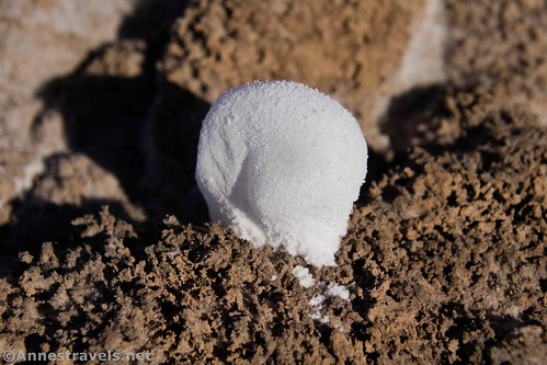
Be sure to look for salt bubbles, salt arches, and other formations in the inverted cracks between the “sidewalk pieces” of salty or brown mud. They’re really cool!

It was another 3 miles to the western edge of the salt flats. By then, we were pretty tired, and we wouldn’t have minded having a shuttle vehicle to pick us up! But we ate lunch and rested in the shade of a desert plant on a hummock of earth, and that gave us the energy to turn around and head back.

Actually, it can be hard to know exactly when you’ve reached the “far side” of Death Valley. There is brown dirt/dried mud with interesting formations, and plain brown hard dirt, then the vegetation begins to creep up, slowly, so you don’t really notice it. Then, before you know it, there are green and yellow Arrow Weed all around, and you’re on the other side of Death Valley!

If you’re just hiking across Death Valley and you want a destination on the West Side Road to shoot for, Shortys Well is a good option. The parking area is approximately 36.226617, -116.880546. You could also leave a shuttle vehicle there.

In some ways, heading back was much more difficult because we were tired. It was endless walking across those inverted sidewalk cracks. But in other ways, the views were just as awesome if not better when we were walking east back toward Badwater Basin. In the winter, Telescope Peak is snowy and spectacular while walking west. But I loved the afternoon light on the salt flats in November. (Telescope Peak had just a little visible snow – it was actually much snowier than it looked, as we found out a few days later when we hiked Wildrose Peak.) While the Black Mountains to the east may not be quite as scenic as the Panamint Mountains to the west, they’re none too shabby in their own right!
We arrived back at Badwater Basin late in the afternoon, 12.9 miles of hiking between our same start and end point… but the views along the way were fantastic!

Round Trip Trail Length: 7.2 miles out & back to the Lowest Point in North America; 11.6 miles out & back across Death Valley; 6.4 mile shuttle between Shortys Well and Badwater Basin; 12.9 miles out & back to cross Death Valley while also visiting the Lowest Point.
Elevation Gain: Badwater Basin to the Lowest Point to the far side of Death Valley and back to Badwater Basin was 338ft. (-272ft. to -282ft.)
Facilities: Primitive restrooms at Badwater Basin

Fees: $30/vehicle/week to enter Death Valley National Park. Death Valley Annual and America the Beautiful National Park & Recreation Passes are also accepted.
Trail Notes: Wear sunglasses – the reflections off of the salt flats are blinding! Don’t try this on a hot day. Take lots of water – it’s dry as dry out there, and the reflected heat is scorching. Do not walk on the salt flats if they’re soft or muddy. Be very careful while hiking – if you fall, that salt is extremely sharp. If it’s a windy day, you just might get blown away out there – that’s fun!

Trail 
![]()
![]()
![]()
Road ![]()
Signs ![]()
![]()
![]()
Scenery
Would I go 100 miles out of my way for this?
Overall Rating: 
![]()

GPS Coordinates for Crossing Badwater Basin/Lowest Point in North America
Badwater TH: 36.2298000°, -116.7673500° (N36° 13.788′ W116° 46.041′ / 36°13’47.2800″, -116°46’02.4600″) (-268ft.) (0.0)
End of the trail-ish path: 36.2310167°, -116.7823000° (N36° 13.861′ W116° 46.938′ / 36°13’51.6600″, -116°46’56.2800″) (-294ft.) (0.88)
Lowest Point in North America: 36.2419167°, -116.8255500° (N36° 14.515′ W116° 49.533′ / 36°14’30.9000″, -116°49’31.9800″) (-281ft.) (3.63)
Western side of Badwater Flats: 36.2387167°, -116.8767000° (N36° 14.323′ W116° 52.602′ / 36°14’19.3800″, -116°52’36.1200″) (-270ft.) (6.59)
End: 36.2298333°, -116.7674000° (N36° 13.790′ W116° 46.044′ / 36°13’47.4000″, -116°46’02.6400″) (-284ft.) (12.92)

The gpx file for the Lowest Point in North America and Crossing Death Valley can be downloaded – please note that this and the GPS Coordinates are for reference only and should not be used as a sole resource when hiking this trail.
Download GPX File size: 186.2 KB Downloaded 505 times
(Note: I do my best to ensure that all downloads, the webpage, etc. are virus-free and accurate; however, I cannot be held responsible for any damage that might result, including but not limited to loss of data, damages to hardware, harm to users, from use of files, information, etc. from this website. Thanks!)

Getting to Badwater Basin Trailhead
From the Furnace Creek Visitor Center, head south on CA-190E. After 1.3 miles, turn right onto the Badwater Road, following signs for Badwater. Drive 16.5 miles to the parking area for Badwater Basin, on right.

Badwater Basin is also on left about 30 miles north of Ashford Junction, where the Harry Wade Road joints the Jubilee Pass Road to become the Badwater Road.

This Week’s Featured Product!
From short strolls and famous sights to long treks and out-of-the-way destinations, this book covers almost 60 trails in Death Valley National Park. Detailed trail descriptions, maps, and more help you find the best hikes in the park.
One response to “Walk Across Death Valley & Lowest Point in North America!”
[…] the top of the list of “must-do” hikes for several of my group members was to hike across Death Valley. A first for about half of my group, the rest of us had only ever hiked it one way, never as […]