
Island in the Sky has some amazing trails. Murphy Point, Grand View, White Rim Overlook, Mesa Arch, and others offer fantastic views without a whole lot of vertical-gain effort. Others – like the Gooseberry Trail, Wilhite Trail, or Murphy Hogback Trail – are a lot of views and a lot of vertical-gain effort as they climb from the mesa-top down to the White Rim Road and back up again. Last time I was in Canyonlands, I had the fantastic opportunity to hike the Lathrop Trail, which is a combination of the two types of trails: you can hike down to the Lathrop Point Overlook with not too much elevation loss, or else you can hike the Lathrop Trail all the way down to the White Rim Road (which is, well, a whole lot of elevation loss). The views along the way are simply fantastic, so I’ll detail the Lathrop Point Overlook this post and we’ll explore further down the Lathrop Trail in another post.
Quick Stats

The Lathrop Trail to the Lathrop Point Overlook is 2.15 miles down the trail from the trailhead and 1,000ft. below the trailhead. So this is still not an easy hike. But along the way, you’ll get to see some pretty fun rock formations (colorful!), a desert meadow, and various views to canyons, rock formations, potash settling basins, the La Sal Mountains, and the Needles if you know where to look for them.

Our morning was not the nicest, but we didn’t have a whole lot of choice in terms of what day we wanted to hike. The views are also better along the trail in the afternoon, but again, we didn’t have a lot of choice in the time of day we could hike. So we took the opportunity that came and did our best. It looked like it was going to rain as we started out from the trailhead across the grassland. The trail is very well-defined and easy to follow.

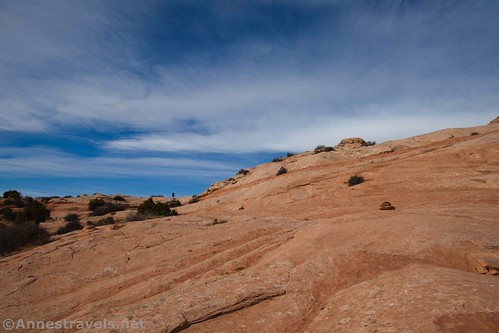
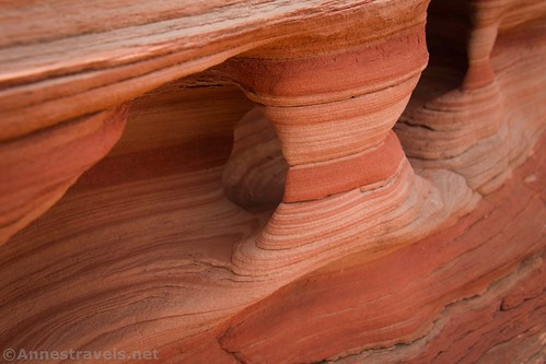
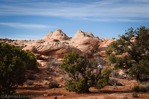
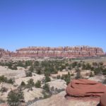
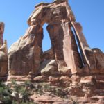
After almost a mile and a half, the trail transitions from dirt to slickrock. Following the trail through this section is a little tricky; cairns (piles of rocks) mark the correct path. It’s made harder by the fact that instead of looking for cairns, my eyes were busy feasting on the white-and-red rock formations. They’re really worth seeing!
Thankfully about this point the sun came out. It played peek-a-boo for the rest of our hike, giving us both beautiful views and relief from the heat of the sun.

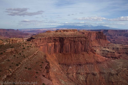
Be sure to look around as you cross the slickrock – views begin to open up to canyons, cliffs, and (if you know where to look) the Needles.

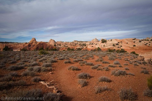
The route begins its descent at this point, plunging down between the formations to a lower bench of red dirt. After winding through some more rock formations (be sure to look back at the red swirls in the white rock!) the trail emerges to wander across a red-dirt-and-green-sagebrush bench.
At very nearly 2.0 miles from the trailhead, the path will veer left off of the bench to descend over white rock down to a lower bench. A vague social trail continues straight along the red-dirt bench, heading for the point at the end of the bench. Turn right-ish to follow this social trail – it’s the path to the overlook.

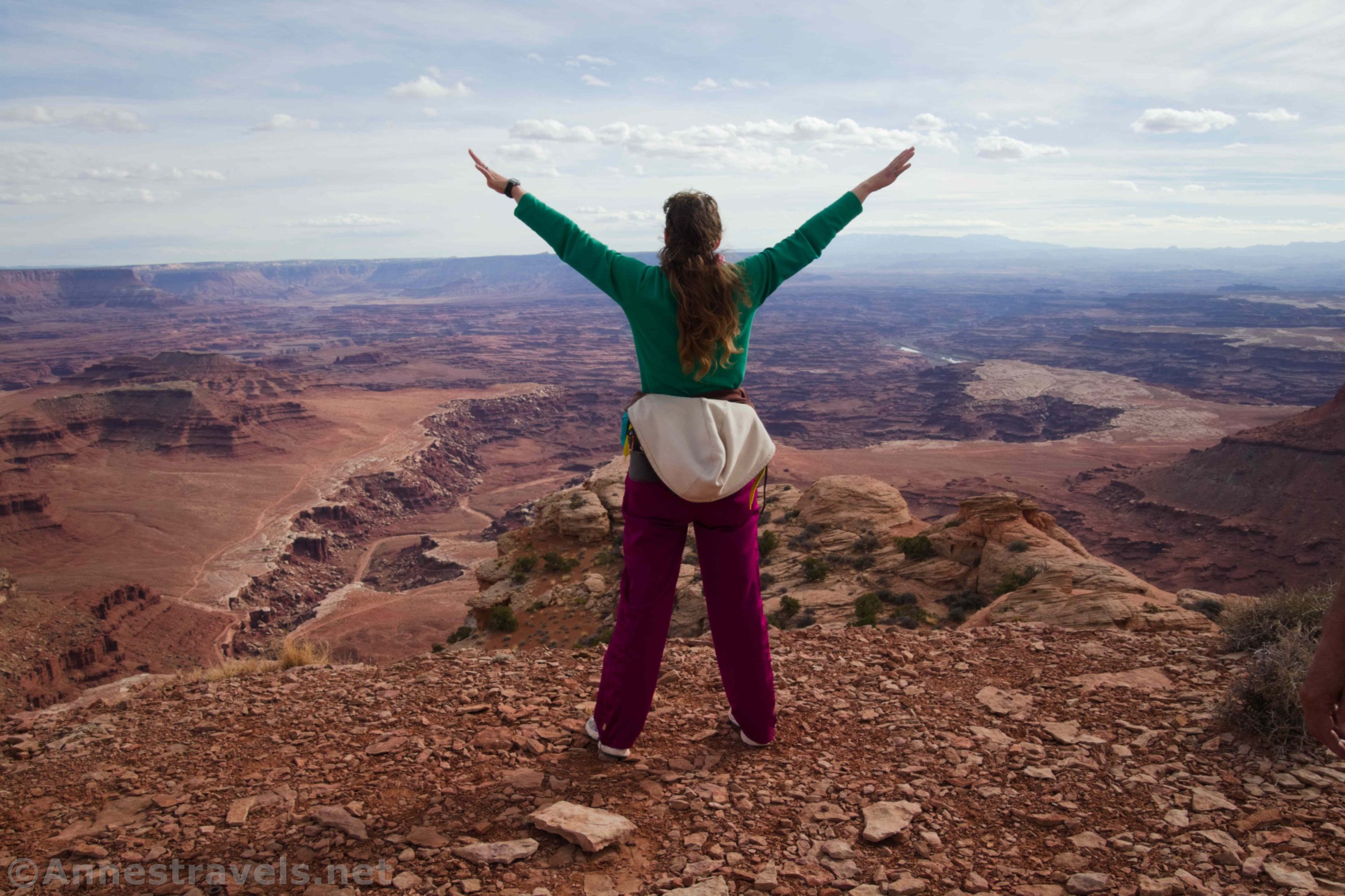
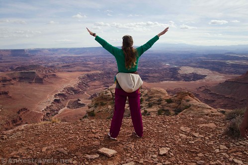
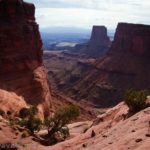
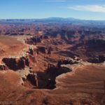
As you walk out toward the end of the bench, the views open up more and more down into the canyons and to the rock formations that point skyward. It’s only 0.15 miles to the first overlook on the end of the red-dirt bench, marked (as of 11/20) with a small rock cairn. The views are stunning!

Once I picked up my jaw off of the ground, I remembered to look left and right. The views are fantastic in those directions, too!

The canyon below the point that seems to descend all the way to the Colorado River is Lower Lathrop Canyon. There’s a road that spurs off of the White Rim Road that goes down to the river.
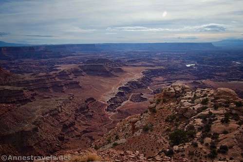
The La Sal Mountains are pretty cool, too. Unfortunately, it was morning – the views would be better in the afternoon. As it was, the views were pretty hazy all day. Most of the views in the photos are from our trek back up a little after noon.
The social trail heads right along the edge of the bench (be careful; there aren’t any guardrails). It peters out fairly quickly, however, and the views aren’t that much better (except down into Lathrop Canyon), so don’t bother unless you want to.

From here, you have two choices. First, you can turn around and go back up to the parking area for a great 4.3 mile-round-trip hike. Or you can continue down the Lathrop Trail toward the White Rim Road – but that’s the topic for another post!

Round Trip Trail Length: 4.3 miles out & back
Elevation Gain: 987ft. (6,127ft. to 5,747ft.)
Facilities: None
Fees: $30/vehicle, valid 7 days. Southeast Utah Parks Passes and America the Beautiful Passes also accepted.

Trail Notes: Use caution near the canyon edges as there are no guardrails and it’s a long way down. Don’t hike this trail during a thunderstorm – there is no cover on the grasslands. I’d say the trail is worth the trek even if you only get to the rock formations. The white rocks with red swirls are quite something to see. There is no real exposure on the trail until the overlook – then there are no guardrails and you’re awfully close to the edge! Many thanks to gjhikes for introducing me to these great overlooks!
Trail 
![]()
![]()
Road ![]()
Signs ![]()
Scenery
Would I go 100 miles out of my way for this?
Overall Rating: ![]()

GPS Coordinates for the Lathrop Point Overlook
Lathrop Trailhead: 38.4337333°, -109.8270000° (N38° 26.024′ W109° 49.620′ / 38°26’01.4400″, -109°49’37.2000″) (6,976ft.) (0.0)
Slickrock: 38.4163667°, -109.8163333° (N38° 24.982′ W109° 48.980′ / 38°24’58.9200″, -109°48’58.8000″) (6,069ft.) (1.47)
Overlook Junction: 38.4128833°, -109.8095167° (N38° 24.773′ W109° 48.571′ / 38°24’46.3800″, -109°48’34.2600″) (5,962ft.) (1.98)
Overlook: 38.4112500°, -109.8079500° (N38° 24.675′ W109° 48.477′ / 38°24’40.5000″, -109°48’28.6200″) (5,978ft.) (2.15)
2nd overlook: 38.4110000°, -109.8084167° (N38° 24.660′ W109° 48.505′ / 38°24’39.6000″, -109°48’30.3000″) (5,975ft.) (2.20)
The gpx file for Lathrop Point Overlook can be downloaded – please note that this and the GPS Coordinates are for reference only and should not be used as a sole resource when hiking this trail.

Download GPX File size: 89.3 KB Downloaded 540 times

(Note: I do my best to ensure that all downloads, the webpage, etc. are virus-free and accurate; however, I cannot be held responsible for any damage that might result, including but not limited to loss of data, damages to hardware, harm to users, from use of files, information, etc. from this website. Thanks!)

Getting to the Lathrop Trailhead
From the Island in the Sky Visitor Center, head south exactly 2 miles to the trailhead, on left. It’s really just a small pulloff with a post-and-rail fence with a break in the fence for the trailhead (and a small sign denoting the name and mileage of the trail). Note that there is only space for about 4-6 vehicles in the pulloff. If there is no space to park, you may be able to park 1.2 miles north at the Schaffer Road Overlook.

This Week’s Featured Product!
For even more hikes in Canyonlands National Park, check out this Falcon Guide to Canyonlands and Arches National Parks.


3 responses to “Views of Eastern Canyonlands from the Lathrop Canyon Overlook”
[…] Views of Eastern Canyonlands from the Lathrop Canyon Overlook […]
[…] the way, we stopped to see the Lathrop Overlook (it’s not official). You could stop right there and have seen glorious […]
[…] After about 1.5 miles, the trail transitions from dirt to slickrock. This is where the real fun begins. Besides the need to follow cairns, the white slickrock is swirled with orange. It’s beautiful! (For more information about this part of the hike, see my post on the Lathrop Point Overlook.) […]