

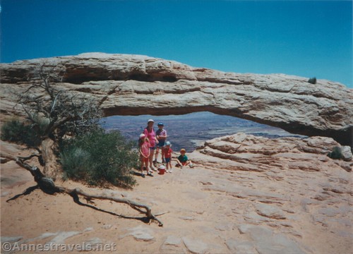
I’ve been to Mesa Arch a few times, and each one carries a special memory with it. On our first visit, we helped a couple of rangers perfectly place a sign at a trail junction. I’m still wondering why a trail maintenance crew at Mesa Arch needed to be armed to the hilt. On our second visit, we brought along a couple of all-terrain strollers for the babies (I don’t recommend this, by the way – that trail is not stroller-friendly!) And the third visit was my most recent: Just after sunrise on a very chilly October morning.
Quick Stats
Note: Some of the links in this post are affiliate links. If you click one and purchase something, I may earn a small commission without an extra cost to you.
I hadn’t planned to hike to Mesa Arch that morning; I hadn’t planned to visit the arch at all. But as we were driving into the park (en route to the Gooseberry Trail), I remembered that sunrise at Mesa Arch was the cover image on a book published by a friend. And since said friend had recently passed away, I decided to do a quick stop – just to remember Frank.

It was just after sunrise, so the parking lot was slowly emptying out. We met crowds of shivering photographers hiking back. But we set out resolutely, deciding to take the trail counter-clockwise by turning right at the trail junction just beyond the parking area.

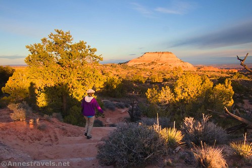
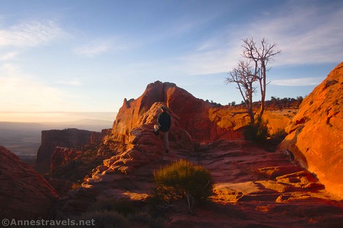
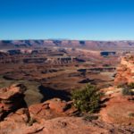
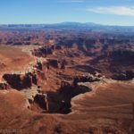
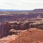
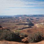
Be sure to enjoy the views along the way. They’re not as spectacular as what you’ll see later, as they’re pretty distant. But you can see domes, cliffs, and of course the grassy top of the mesa.

Looking back at the parking area, you get a pretty good view of Aztec Butte, too.

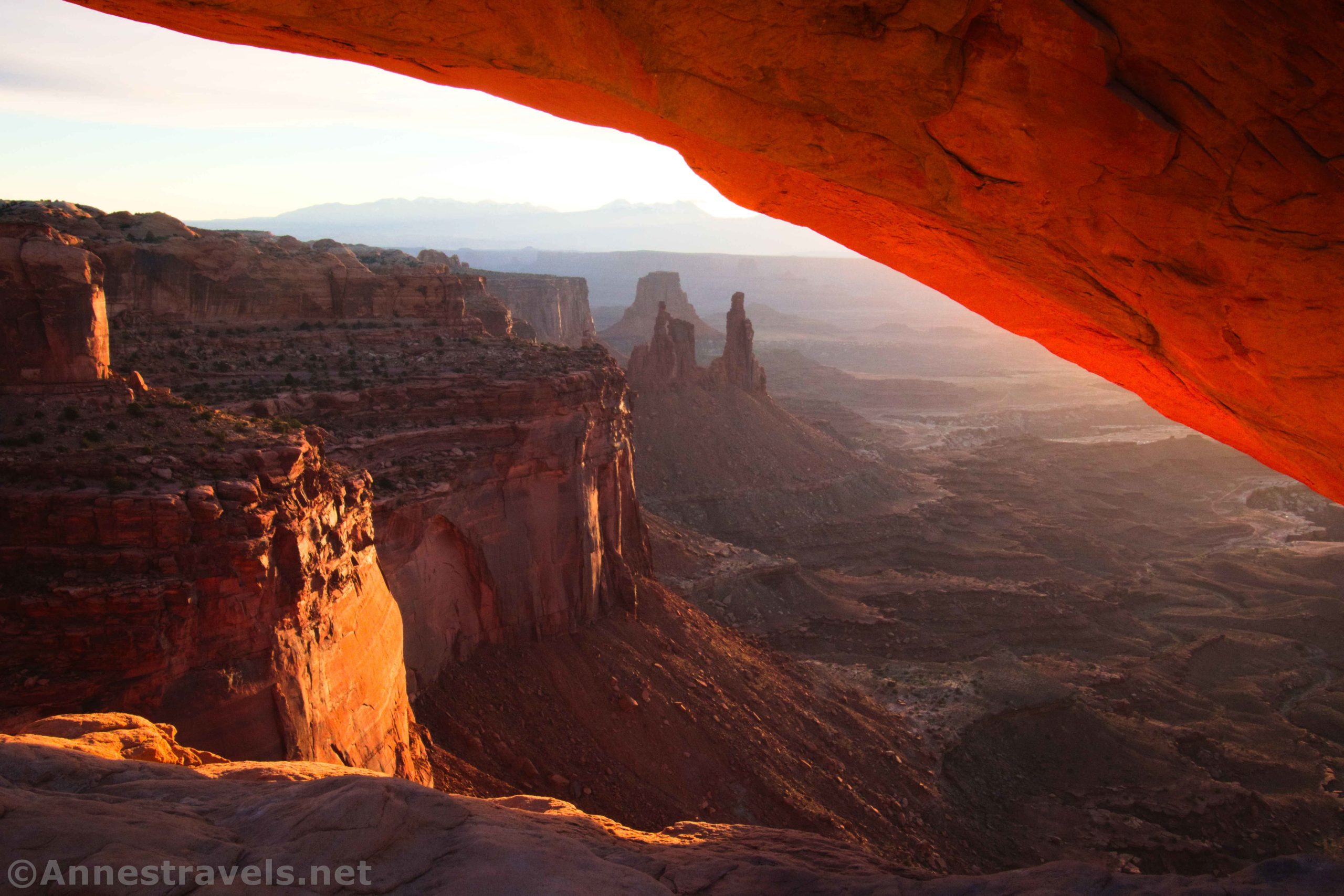
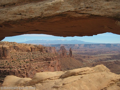
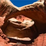
At 0.3 miles from the parking area, you’ll come to Mesa Arch. The sun might have already risen, but there were still ample opportunities for pictures. A few of the better-prepared photographers were still hanging around, watching the sunrise and taking whatever opportunities presented themselves. A hiker let me photograph her in the arch.

In general, the atmosphere was pretty relaxed. Most of the serious photographers had already gotten their classic shots, so it was just a kind of fun, “now what can we do that will be nice?” instead of a frantic attempt to get the best shot ever.

We tried to stay out of the way while positioning ourselves for great shots of our own and to enjoy the sunrise through Mesa Arch. One of my group members took a photo and later used it as a desktop photo on her laptop. Her boss’s boss’s boss happened to see it one day in a meeting… he asked her if it was a stock photo. I’d call that a score!

After admiring the view from various angles, we high-tailed it down the trail to complete the loop and return to the parking area.
It’s short and sweet, but if you get a chance to see Mesa Arch just after sunrise, I highly recommend it! In the middle of the day, and in the afternoon, it’s also nice – for one thing, you can actually see the La Sal Mountains which are usually silhouetted by the sun at sunrise!
Round Trip Trail Length: I ended at 0.75 miles
Elevation Gain: 186ft. (6,184ft. to 6,073ft.) (I’d guess this is an overstatement.)
Facilities: Primitive restroom in parking area
Fees: $30/vehicle, valid 7 days in all districts of Canyonlands. National Park & Federal Lands Passes and Southern Utah Parks Passes are also accepted.
Trail Notes: Sunrise is the most popular time of day to visit Mesa Arch, but there are good view-related reasons to visit at other times of the day, as well. I’d say if you miss sunrise, you’re better off waiting until afternoon for the best views. Try to be courteous and take your turn at the arch without hogging it. That said, don’t let pushy photographers keep you from enjoying it, too! The path has several small sets of steps, so it’s not wheelchair or stroller-friendly.

Trail 
![]()
![]()
![]()
Road ![]()
![]()
![]()
Signs ![]()
![]()
![]()
![]()
Scenery
Would I go 100 miles out of my way for this?
Overall Rating: ![]()
![]()

GPS Coordinates for Mesa Arch
TH: 38.389140,-109.868040 (38°23.34840′, -109°52.08240′ / 38°23’20.9040″, -109°52’04.9440″) (6,149ft.) (0.0)
Mesa Arch: 38.388057,-109.863661 (38°23.28342′, -109°51.81966′ / 38°23’17.0052″, -109°51’49.1796″) (6,097ft.) (0.33)
End: 38.389127,-109.868033 (38°23.34762′, -109°52.08198′ / 38°23’20.8572″, -109°52’04.9188″) (6,148ft.) (0.74)
The gpx file for Mesa Arch can be downloaded – please note that this and the GPS Coordinates are for reference only and should not be used as a sole resource when hiking this trail.
Download GPX File size: 14.8 KB Downloaded 484 times
(Note: I do my best to ensure that all downloads, the webpage, etc. are virus-free and accurate; however, I cannot be held responsible for any damage that might result, including but not limited to loss of data, damages to hardware, harm to users, from use of files, information, etc. from this website. Thanks!)

Getting to Mesa Arch
From the Island in the Sky Visitor Center, drive south on the main road. Exactly 6 miles south of the visitor center, the Mesa Arch Trailhead will be on your left (east). If you come to the turnoff for Upheaval Dome, you’ve gone 0.3 miles too far.

This Week’s Featured Product!
The more than 60 hikes in this book take you to some of the best views and features in Arches and Canyonlands National Parks. You’ll see canyons, vistas, arches, historic structures, and so much more. Buy your copy here!

2 responses to “Mesa Arch Just After Sunrise”
[…] District of Canyonlands National Park. Driving in, right at sunrise, I had to stop and hike to Mesa Arch in memory of my friend Frank Ruggles. He’d have appreciated […]
[…] Mesa Arch […]