
Last week, I posted about hiking the Gooseberry Trail, better known as the fastest route between the rim of Island in the Sky to the White Rim Road in Canyonlands National Park. This week, I’d like to take you along on our trek from the bottom of the Gooseberry Trail to an overlook of Monument Basin with its fantastic formations. Along the way, you’ll get some pretty great views. But be warned: There is no trail in some sections and you’ll be scrambling up some definite Class 3 slopes.
Quick Stats
Note: Some of the links in this post are affiliate links. If you click one and purchase something, I may earn a small commission without an extra cost to you.

Actually, there’s no reason you couldn’t just walk along the White Rim Road to the rim of Monument Basin and have a fairly flat trail the entire way. The problem with this route is that it’s 2.4 miles longer – each way! And considering that you’re already hiking the 5 mile (RT) Gooseberry Trail, you really don’t need any extra mileage.
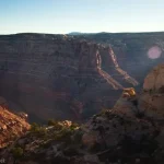
The other good reason to hike the overland route is that you get views of Monument Basin sooner. We were racing against daylight, so we didn’t end up taking the entire route down to the rim of the basin; instead, we stopped at the top of the pass and enjoyed the great views from up there.
I first read about the possibility of doing this hike over on the American Southwest website (a great resource!) Then the website owner listed it as one of his favorite hikes in all of Canyonlands. I was sold, and he was right: It’s a really beautiful hike!
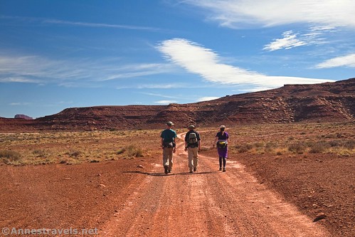
From the bottom of the Gooseberry Trail, turn right (south) on the White Rim Road. Pass by the two Gooseberry Campsites (Campsite B has a primitive restroom about 0.4 miles from the Gooseberry Trail) and continue along the road.
You want to go around one small arm off of the main arm of the mesa (the White Rim overlook is up on top of the mesa somewhere!)
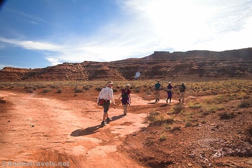
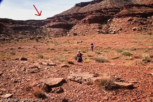
About 0.9 miles from the bottom of the Gooseberry Trail, you’ll cross a wash. There have been several washes up to this point, but this is the biggest yet and obviously heads south toward a saddle in the arm of the mesa that extends out across the White Rim. (This is why the White Rim Road is so much longer than the overland route – it has to go around this arm, whereas we’re going to climb over it.)
Turn right (south) up this wash. (Note: On the map, you can see that I continued on the road a short distance further to the point where the road takes a sharp turn to travel due east – I went off-trail back to the wash, but just walking up the wash is easier.)
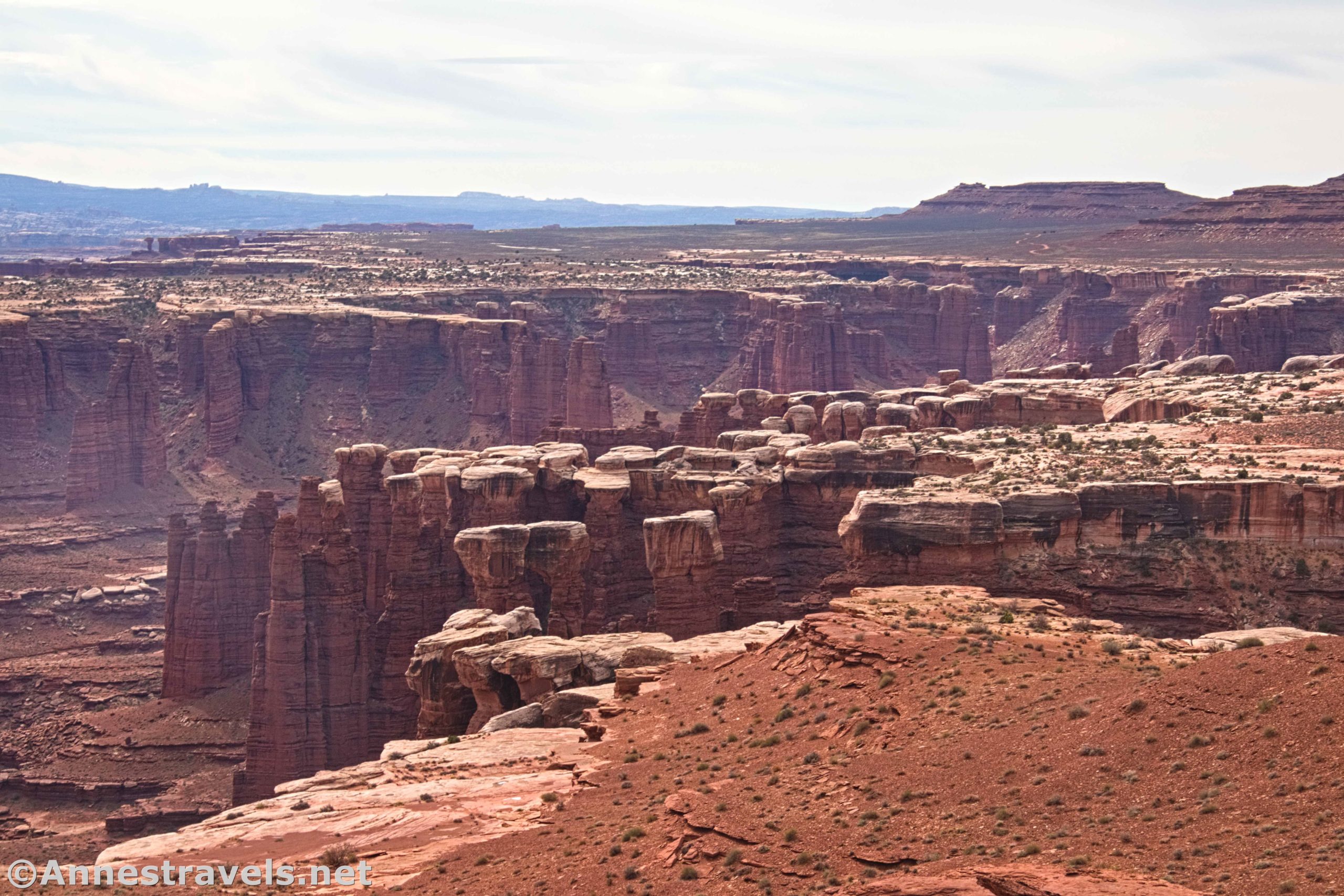
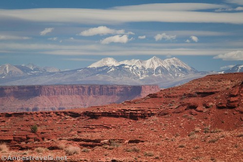
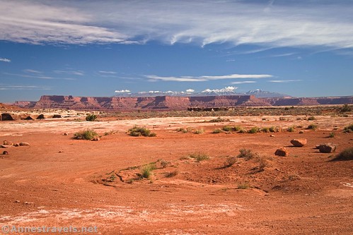
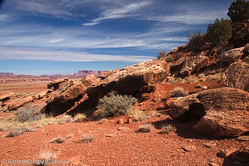
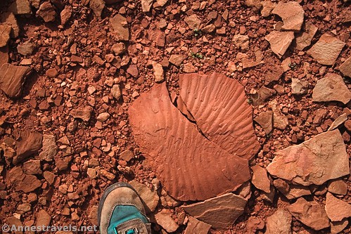
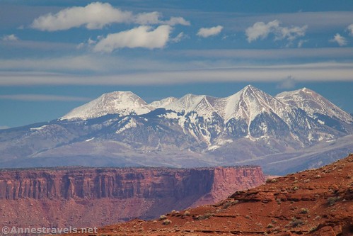
At first, the wash is somewhat wide, sandy, and easy walking. Keep your eyes open for fantastic rock formations and great views in this section (especially back toward the La Sal Mountains).

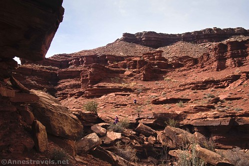
As you approach the arm of the mesa, the wash becomes much rockier. It may even look impossible. However, you can skirt most of the large rocks and continue generally up the wash.

As you climb, choose your route carefully. There are plenty of impossible ways to do this and a few good ways to do the same thing. Also, some slopes are more stable than others.

My group scouted out several routes to ascend into the saddle. The easiest one we found was a little to the left of the head of the wash via a crack in the rim rocks. I was grateful for a hand up this, as it would be easier for taller people. Even so, it was a definite Class 3 scramble. A bit more zigzagging and scrambling brought us up to the top of the saddle. Yay!
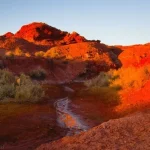
Look back down at the way you’ve come. There are some pretty good views in this direction, especially in the fall/winter when the sun is pretty far south.

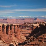
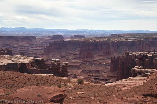
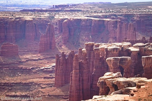
It’s an easy walk across the top of the saddle and over to views down on Monument Basin. Wow!

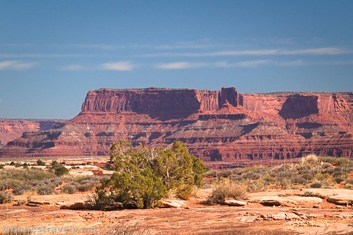
You can also see quite a stretch of the White Rim Road and the cliffs of Island in the Sky.

And if you look south and a little east, you can see the Needles!

Unfortunately, the sun deserted us about this point, so my pictures aren’t the best for two reasons: 1) it was cloudy/hazy, and 2) shooting south in October just doesn’t work very well due to the sun making its way further south. But the conditions did make for some interesting lighting.

From here, I’ve heard that it’s possible to walk to the right and scramble down an arm of the mesa to get to the White Rim Road. From there, it’s a simple thing to walk over the very rim of Monument Basin.
Unfortunately for me, we were racing against daylight, so we didn’t try this. Instead, we stayed on the southern rim of the saddle and enjoyed the views.

Return the way you came: Back down through the crack in the rock, back down the wash, back up the White Rim Road, and then back up the Gooseberry Trail to the parking area!

Round Trip Trail Length: I ended at 8.75 miles; without some of my little detours, I’d put it closer to 8.3 miles from the Gooseberry Trailhead to the saddle overlooking Monument Basin and back
Elevation Gain: 2,716ft. (6,275ft. to 4,596ft.)
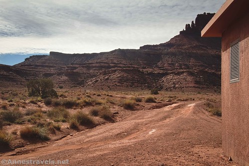
Facilities: Picnic facilities and one primitive restroom at the Gooseberry Trailhead. A primitive restroom is located near the second Gooseberry Campsite.
Fees: $30/vehicle, valid 7 days. Southeast Utah Parks Pass and America the Beautiful passes are also accepted.

Trail Notes: Much of this route is off-trail. Be very comfortable and experienced in off-trail navigation, trail-finding, and scrambling before you attempt this route. Be wary of vehicles on the White Rim Road – most drivers are very courteous of hikers, but it pays to be careful. The route is very exposed and dry; don’t try this one in the summer or on a hot day. Be sure to look at views down on Gooseberry Canyon as you walk by its head – it’s incredible, especially in the afternoon.
Trail 
![]()
![]()
![]()
Road ![]()
Signs ![]()
![]()
![]()
Scenery
Would I go 100 miles out of my way for this?
Overall Rating: 
![]()

GPS Coordinates for the Gooseberry Trail to Monument Basin Overlook
Gooseberry Trailhead: 38.322842,-109.849479 (38°19.37052′, -109°50.96874′ / 38°19’22.2312″, -109°50’58.1244″) (6,262ft.) (0.0)
White Rim Overlook Junction: 38.323031,-109.848374 (38°19.38186′, -109°50.90244′ / 38°19’22.9116″, -109°50’54.1464″) (6,255ft.) (340ft.)
Begin descent: 38.323210,-109.847540 (38°19.39260′, -109°50.85240′ / 38°19’23.5560″, -109°50’51.1440″) (6,260ft.) (0.13)
Wash: 38.328575,-109.846638 (38°19.71450′, -109°50.79828′ / 38°19’42.8700″, -109°50’47.8968″) (5,074ft.) (1.12)
Sign at White Rim Road: 38.335104,-109.829010 (38°20.10624′, -109°49.74060′ / 38°20’06.3744″, -109°49’44.4360″) (4,736ft.) (2.49)
Return to White Rim Road after lunch: 38.335132,-109.828774 (38°20.10792′, -109°49.72644′ / 38°20’06.4752″, -109°49’43.5864″) (4,732ft.) (2.87)
Gooseberry Campground: 38.330379,-109.827081 (38°19.82274′, -109°49.62486′ / 38°19’49.3644″, -109°49’37.4916″) (4,794ft.) (3.28)
Leave Road: 38.325929,-109.820630 (38°19.55574′, -109°49.23780′ / 38°19’33.3444″, -109°49’14.2680″) (4,829ft.) (3.80)
Top of pass: 38.318661,-109.823884 (38°19.11966′, -109°49.43304′ / 38°19’07.1796″, -109°49’25.9824″) (5,125ft.) (4.54)
Return to the White Rim Road: 38.326581,-109.821305 (38°19.59486′, -109°49.27830′ / 38°19’35.6916″, -109°49’16.6980″) (4,824ft.) (5.32)
Gooseberry Trail/White Rim Road Junction: 38.335119,-109.82884 (38°20.10714′, -109°49.73040′ / 38°20’06.4284″, -109°49’43.8240″) (4,733ft.) (6.24)
End: 38.322847,-109.849497 (38°19.37082′, -109°50.96982′ / 38°19’22.2492″, -109°50’58.1892″) (6,262ft.) (8.74)
The gpx file for the Gooseberry Trail to the Monument Basin Overlook can be downloaded – please note that this and the GPS Coordinates are for reference only and should not be used as a sole resource when hiking this trail.
Download GPX File size: 170.6 KB Downloaded 388 times
(Note: I do my best to ensure that all downloads, the webpage, etc. are virus-free and accurate; however, I cannot be held responsible for any damage that might result, including but not limited to loss of data, damages to hardware, harm to users, from use of files, information, etc. from this website. Thanks!)

Getting to the Gooseberry Trailhead
From the Island in the Sky Visitor Center, drive south on the main road. Continue straight toward Grand View Overlook when the road to Green River Overlook, the Campground, Upheaval Dome, etc., goes off on the right. About 11.3 miles south of the visitor center, turn left, following the sign for the picnic area and restrooms. Halfway around the one-way loop, there will be a half a dozen or so parking spaces on the right next to the trailhead.

This Week’s Featured Product!
If you’re looking for one of the most all-encompassing guides I’ve ever found for Canyonlands National Park, this is it! I love the level of detail, trivia, and maps in this book. Buy your copy here!