

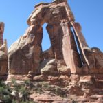
Upper Salt Creek was a hike I’d had my eye on for quite a while. I’d even almost convinced my group to do it back in 2020 on our way back from Death Valley (we landed in Arches and Island in the Sky instead, so we made out just fine). But our final area of exploration in the Canyonlands area the next year was to the Upper Salt Creek Trailhead. We hiked down into the canyon, then walked down to Kirk Cabin and bushwacked our way to a closer vantage point of Kirk Arch (that exploration is the topic of another post).
Quick Stats
Note: Some of the links in this post are affiliate links. If you click one and purchase something, I may earn a small commission without an extra cost to you.
In some ways, Upper Salt Creek didn’t live up to my hype. There is quite a lot of brush in the canyon bottom, and while there’s a reasonable trail (so you don’t have to hike in the wash – yay!), there aren’t many views of the rock formations that line the edges and rim of the Salt Creek Canyon. In other ways, it was a nice enough hike – especially if you’re trying to get away from the crowds – even if it’s not as scenic as I was expecting. It’s unlikely you’ll meet more than a few backpackers down here!

The trailhead is in Bear Ears National Monument, along what I call the Cottonwood Road. Map programs can’t agree on the road name (for example, Google says the road begins next to the “Beef Basin Bathrooms,” despite the fact that Beef Basin is about 34 miles and several turns down the road – other names include Bridger Jack Road, Beef Basin Road, and CR-107). All that said, the road is dirt and is usually accessible to high-clearance vehicles. Low-clearance vehicles can do it in dry weather (a creek crossing at the beginning of the road is the most difficult part (along with a few small washes); I did it in a Toyota Camry and only scraped the undercarriage once on a tight turn where a wash crossed the road). The trailhead is generally known as Upper Salt Creek Trailhead, Salt Creek Trailhead, or Cathedral Butte Trailhead (the namesake is east, across the road).
A reasonable-sized parking lot marks the trailhead along with a metal sign with a map and other information. Finding the beginning of the trail is a little more challenging; keep walking southwest along the canyon rim to the point where it turns right to begin its downward plunge.

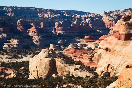
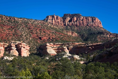
The descent is via a deeply eroded trail that takes short switchbacks steeply downward. This is the steepest part of the trail and definitely a force to be reckoned with on the way back up! Thankfully, the steep section is short, and the trail levels out after about 0.4 miles. As you descend, there are good views down into the Upper Salt Creek Drainage. Enjoy these views – they’re good both in the morning and evening!

About 0.75 miles from the trailhead, you’ll come to a rocky area. The train turns left here to descend a rocky chute into a side wash off of the main Salt Creek Wash (actually, it’s the East Fork of Salt Creek, but that’s technicalities). This is the most difficult part of the trail, but thankfully, the rockiness decreases over time as the trail follows the side wash down and then drops into the sandy bottom of the side wash. Actually, I wondered if it would be as bad as Lava Falls and was quite happy to find it an easier trek than that!

The trail finally crosses the main Salt Creek Wash (East Fork, actually) about mile 1.9. This area was a little tricky for me, but cross the wash and locate the trail that goes up the other side. Within a tenth of a mile, you’ll come to a sign welcoming you to Canyonlands National Park, complete with its special regulations (namely, no bicycles, firearms, campfires, or dogs). Before this, you were in Bear Ears National Monument.
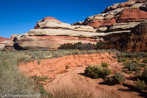
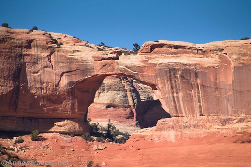
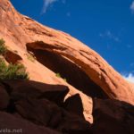
The trail turns right to take you downstream on an embankment above the west side of the wash. You can’t really see this, because brush grows up along the trail. I wasn’t sorry to be wearing leggings that day, but they’re not necessary. Be sure to look up on the canyon walls for various rock formations. You might even spot Wedding Ring Arch, high on the eastern (right) cliffs maybe 3 miles from the trailhead.

After a while, the trail passes through a meadow section. This can be muddy in wet weather (it was very dry in late October, even though it had rained that week), and – so I hear – the path can be difficult to follow. I had no trouble at all, but helpful volunteers have tied red or pink ribbons to trees to mark the correct route. I have a feeling these may occasionally move when the park service decides to reroute the trail for whatever reason.

My favorite part of the marsh section was walking through a reed area. They were much taller than my head and reminded me of bamboo.

The trail eventually ends up on the right (east) side of the wash and passes under a rock overhang. A spring is nearby. Look on the wall for rock art (and some not-quite-so-ancient rock art). I also found a bear print in what was once mud.

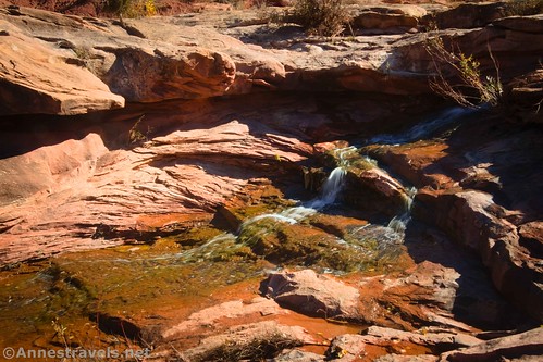
About mile 4.1, you’ll suddenly come out of the foliage at the top of a seasonal waterfall. I felt super blessed to have water running over it; the waterfall was so pretty!
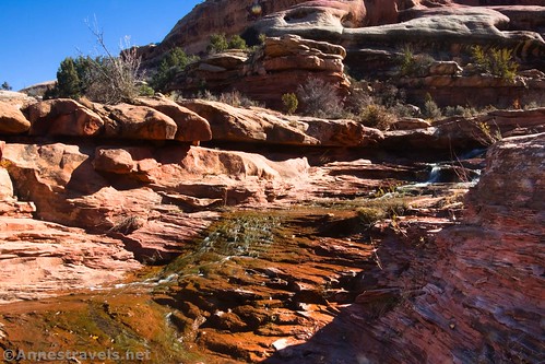
We hung around the waterfall for a while and ate lunch. There are also a few views downcanyon from the top of the falls.

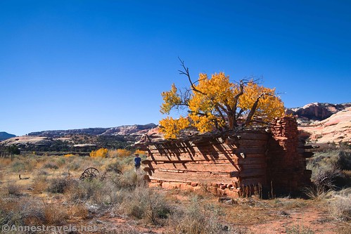
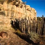
If you’ve come this far, it’s well worth continuing another quarter mile to Kirk Cabin. Outside are the remains of a corral and an old wagon. The cabin is sturdy if not exactly watertight.

The history of Kirk Cabin goes something like this: Around 1890, Rensselaer Lee Kirk began homesteading in the Salt Creek drainage. He built the cabin and two corrals but left after only a few years. Various cowboys and explorers used the cabin through the 1960s when Canyonlands became a National Park.
Be sure to look up on the opposite wall (west wall) of the canyon for the huge Kirk Arch. Our next order of business was to get a closer look at the arch, but that’s a topic for another post!
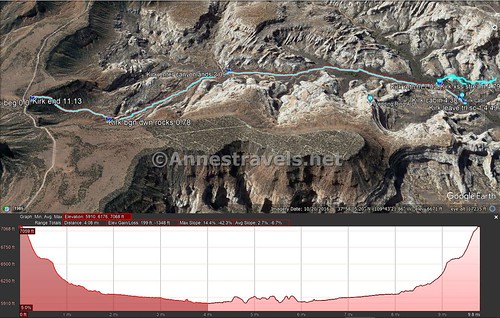
Round Trip Length: To Kirk Cabin and back, per my GPS, would have been 8.8 miles – I have a feeling it’s closer to 8.0 miles. (The GPS sometimes gets confused in canyons or very remote areas.) Note that the first two campsites in Upper Salt Creek (SC1 and SC2) are located a tenth of mile beyond the cabin.
Elevation Gain: 1,538ft. (7,068ft. to 5,915ft.)
Facilities: None. There are quite a few primitive campsites along the road not too far from the trailhead (BLM rules apply).
Fees: $30/vehicle, valid 7 days to enter Canyonlands National Park. America the Beautiful National Parks and Federal Recreational Lands Passes and Southeastern Utah Parks Passes are honored.

Trail Notes: The trail continues down to Lower Salt Creek Trailhead in the Needles District – a total of 21 miles to Peek-a-boo Camp or 24.3 miles to get to the trailhead. It’s frequently backpacked. Permits are required for camping in the sites along the trail (currently $5/person/night + $36/permit). If you go slightly beyond the first two campsites, you can walk right (east) into Big Pocket, a type of desert meadow with some exploration opportunities. Upper Salt Creek is often quite dry; I was surprised to find water flowing over the falls. Very little air moves down Upper Salt Creek Canyon, so it would be an extremely hot hike on a warm day.

Trail 
![]()
![]()
Road ![]()
Signs ![]()
![]()
![]()
Scenery
Would I go 100 miles out of my way for this? ![]()
Overall Rating: 
![]()

GPS Coordinates for Upper Salt Creek to Kirk Cabin
Upper Salt Creek TH: 37.950059, -109.706573 (37°57.00354′, -109°42.39438′ / 37°57’00.2124″, -109°42’23.6628″) (7,052ft.) (0.0)
Begin down wash/rocks: 37.957451, -109.710484 (37°57.44706′, -109°42.62904′ / 37°57’26.8236″, -109°42’37.7424″) (6,535ft.) (0.78)
Enter Canyonlands National Park: 37.961195, -109.729654 (37°57.67170′, -109°43.77924′ / 37°57’40.3020″, -109°43’46.7544″) (6,055ft.) (2.09)
Waterfall: 37.983102, -109.745401 (37°58.98612′, -109°44.72406′ / 37°58’59.1672″, -109°44’43.4436″) (5,931ft.) (4.12)
Kirk Cabin: 37.985592, -109.743761 (37°59.13552′, -109°44.62566′ / 37°59’08.1312″, -109°44’37.5396″) (5,909ft.) (4.38)
End: 37.950070, -109.706595 (37°57.00420′, -109°42.39570′ / 37°57’00.2520″, -109°42’23.7420″) (7,051ft.) (11.13 because I also went off-trail to explore around Kirk Arch)

The gpx file for Upper Salt Creek to Kirk Cabin (and my trek toward Kirk Arch) can be downloaded – please note that this and the GPS Coordinates are for reference only and should not be used as a sole resource when hiking this trail.
Download GPX File size: 231.7 KB Downloaded 560 times
(Note: I do my best to ensure that all downloads, the webpage, etc. are virus-free and accurate; however, I cannot be held responsible for any damage that might result, including but not limited to loss of data, damages to hardware, harm to users, from use of files, information, etc. from this website. Thanks!)

Getting to the Upper Salt Creek Trailhead
From US-191 39 miles south of Moab, Utah (or 14.4 miles north of Monticello), turn onto UT-211 (signed for Canyonlands National Park and Newspaper Rock). Drive 20.2 miles to a somewhat unassuming dirt road on the left. No sign marks the junction, but there are three ways to find it: 1) it has a cattle guard (not that helpful; many of the sideroads have cattle guards), 2) it’s right after passing a sign with some of the park rules (I think that’s what it’s about; I’m usually driving in after dark), and 3) there is a primitive restroom almost as soon as you leave the pavement (a signboard is near the restrooms). There may also be signs about Beef Basin or Elk Mountain; however, I believe these signs have not been up in a while.

Stay on the main dirt road (gravel at this point) as it crosses a wash (sometimes with water in it – I broke ice on my last visit and was grateful for high clearance!). If you can pass this obstacle, you’re probably good to go to get to the Upper Salt Creek Trailhead.

Follow the road as it winds past buttes, canyon walls, sideroads, campsites, and generally beautiful scenery. In general, the road is typically in reasonable repair (I did it in a Toyota Camry) but does have washboard. Use caution when the road crosses small washes on corners; these can be harmful to a low-clearance undercarriage).

At long last, 16.7 miles from the pavement, pass by a sideroad on your right. This is the Big Pockets Overlook Road and is 4×4 only, but it’s a good indication that you’re almost there. A mile later, you’ll come to the driveway into the parking area for Upper Salt Creek. Yay! You made it!
This Week’s Featured Product
Check out one of my favorite resources on Canyonlands National Park in the form of this book! It includes maps, great history, detailed trail descriptions, and roads and trails that may or may not be covered in other guidebooks. Buy your copy here!


One response to “Upper Salt Creek to Kirk Cabin”
[…] week, I wrote about hiking Upper Salt Creek Canyon to Kirk Cabin in Canyonlands National Park. I had read of the possibility of scrambling overland to Kirk Arch, […]